USSR - MPS Central Council of VDOC "Lokomotiv"
Description
Traverse made by the team of CC VDOC "Lokomotiv", Shkhelda-Ushba with ascent via the northern wall to the 3rd Western Shkhelda-Tau
Konkov I.P. + 5 people 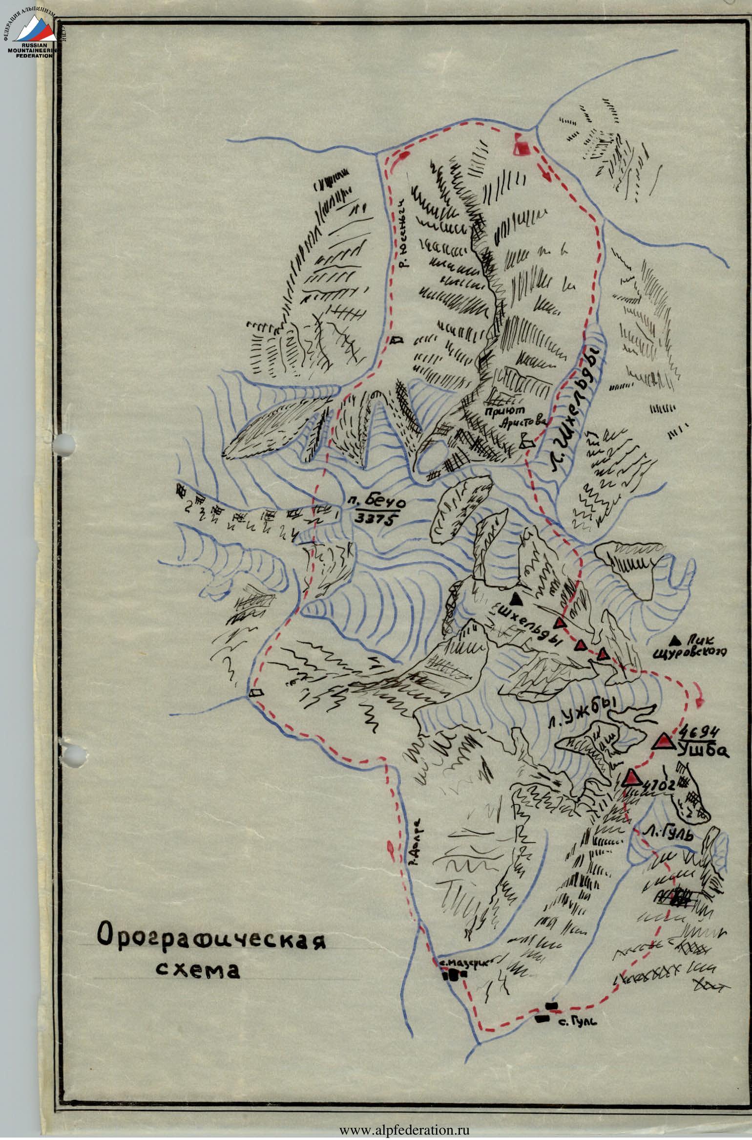
Description of the Shkhelda-Ushba traverse with ascent via the northern wall to the 3rd Western Shkhelda (by "Rybka"), carried out from August 8 to August 22, 1965.
August 8
10:30. The team of CC VDOC "Lokomotiv" consisting of five members of the assault group and two observers left the camp to make the Shkhelda-Ushba traverse with ascent via the northern wall to the 3rd Western Shkhelda.
14:00. Bivouac was set up at "Aristov's overnight stay".
18:00. Trial radio communication with the camp and the observation group was conducted.
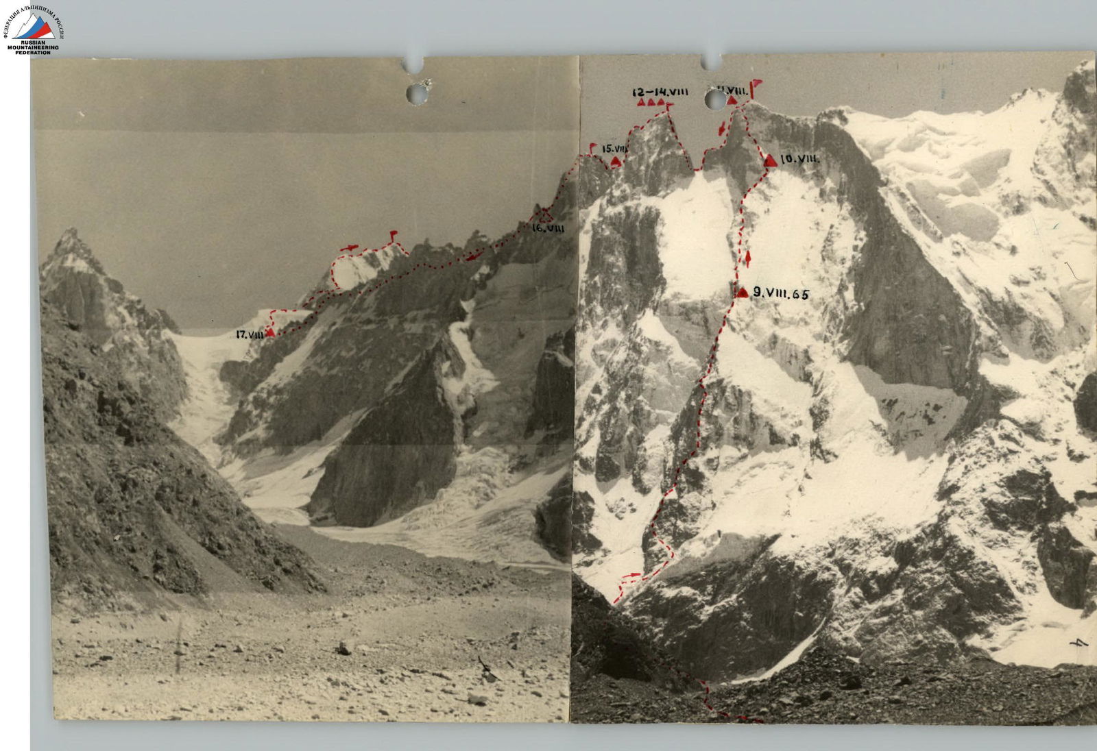
August 9 - 1st day of ascent up the wall
4:00. Excellent weather. We head under the northern wall of the 3rd Western Shkhelda-Tau.
5 hours 10 minutes. The ascent initially goes along a firn slope cut by numerous bergschrunds, after the first 100 m of ascent the slope steepness increases to 40°. Moving up-left, we start traversing to a large bergschrund. After passing it, we reach the rocks.
6 hours 00 minutes. Movement along the rocks of medium difficulty in the direction of a clearly visible saddle. The rocks up to the saddle are destroyed, местами smoothed, with a steepness of 45-60°, belay via pitons, length 4 ropes.
7 hours 30 minutes. The ascent to the large wall (200 m) goes from the saddle along easy rocks (one rope), then along gray slabs. The rocks are difficult (2 ropes), steepness 70-80°, belay via pitons.
8 hours 30 minutes. Gray slabs lead to the "Ryжая стена" (Red Wall). The wall is bypassed along rocks of medium difficulty on the right side (1 rope) in the direction of a narrow crevice. Movement along the narrow crevice 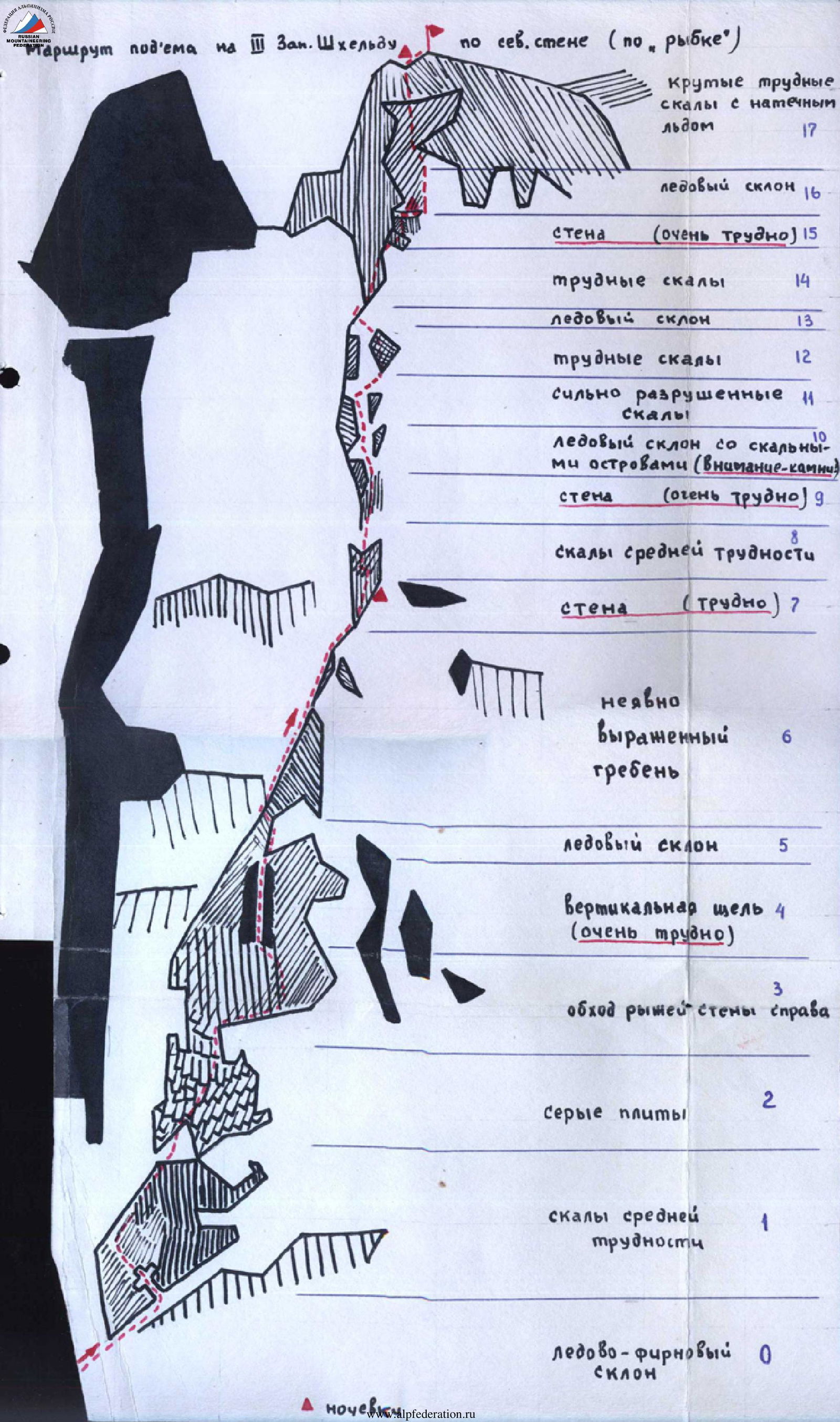
is very difficult (2 ropes) with a steepness of 70-90°, rocks are smoothed (like "ram's foreheads"), with glacial ice in the upper part of the crevice. During the ascent along this section, ladders and pitons are used, backpacks are pulled up.
11 hours 30 minutes. The crevice leads to an ice slope descending from the northern walls of the 3rd Western Shkhelda. Then we move sharply left along rocks of medium difficulty (2.5 ropes) in the direction of an indistinctly expressed ridge, belay via outcrops and pitons. The further path goes along rocks of varying difficulty. The encountered "dzhendarms" (rocky pinnacles) are bypassed on the left. Belay is organized via outcrops and pitons. The section ends with a wall (35 m), which we ascend along the left side, along difficult rocks (70-80°), belay via pitons. The wall ends with a platform suitable for a bivouac.
13:30. A note from the control tower was retrieved. The platform for overnight stay was cleared and expanded. After a short rest, the pair processes the further route for one rope.
18:00. Radio communication with the observation group was conducted. The communication is excellent.
August 10 - 2nd day of ascent up the wall
4:30 am. Good weather, cold in the morning, light wind. From the bivouac, we move along the processed section (1 rope): rocks of medium difficulty, and then along a 45-meter wall with a steepness of 60-90°.
6:00 am. The wall leads to an ice slope with rocky sections. This is the so-called "tail of Rybka" - a very difficult section of the route, prone to rockfall, with a steepness of 50-60°. We move left (2 ropes) under the cover of rocks. We reach the "tail of Rybka". The steepness of this section is 60-80°, belay via pitons. Further movement goes along strongly destroyed rocks of medium difficulty, complicated by freely lying stones (2 ropes). Then rocks of medium difficulty are replaced by difficult ones with a steepness of 60-90°. The ascent along them leads to an ice slope 20 m wide, which we traverse towards a rocky ridge. Belay via pitons, we cut steps. The ascent along difficult rocks goes in the middle part of "Rybka" (1 rope), and then 15 m along an ice slope with an exit to difficult rocks with a steepness of 60-75° (1 rope), which lead under the tower.
14:30. The beginning of the ascent to the tower passes along very difficult rocks, with a steepness of 80-90°. Movement along the wall was done on ladders, backpacks were pulled up, belay via pitons.
18:00. Bivouac on a ledge of the wall, overnight stay is sitting, with two people sitting in one place and three in another.
August 11 - 3rd day of ascent up the wall
6 hours 00 minutes. Clear weather, strong wind. From the ledge, the ascent goes along an ice slope to rocks of medium difficulty (1 rope). Further movement passes along icy and snow-covered rocks, until we reach the ridge of Shkhelda. The steepness of the section is 60-90°, belay via pitons (3 ropes).
13:00. From the summit of the 3rd Western Shkhelda, a note and a "drop" were retrieved. We descend from the summit for one rope and stop for the night.
18:00. Communication with the camp and the observation group is excellent.
August 12 - 1st day of traverse
8 hours 00 minutes. Cloudy, strong wind blows, signs of worsening weather. Descent from the 3rd Western Shkhelda initially goes to a saddle under it. Ascent along a short ridge and approach to the beginning of the wall. 1st descent, sitting on a rope. The wall has negative angles in some places.
The descent consists of several sections:
- The first descent (about 40 m) leads to a small inclined ledge on the right side.
- Followed by a second descent (about 35 m) to a gentle ridge.
- From it, a descent is made to the right side, bypassing a "dzhendarms" (rocky pinnacle) along a rocky ledge (one rope).
- Then a 3rd descent by rope (20 m) to a small ledge above the saddle between the 3rd Western and Central Shkhelda.
- 4th descent (40 m) to the saddle.
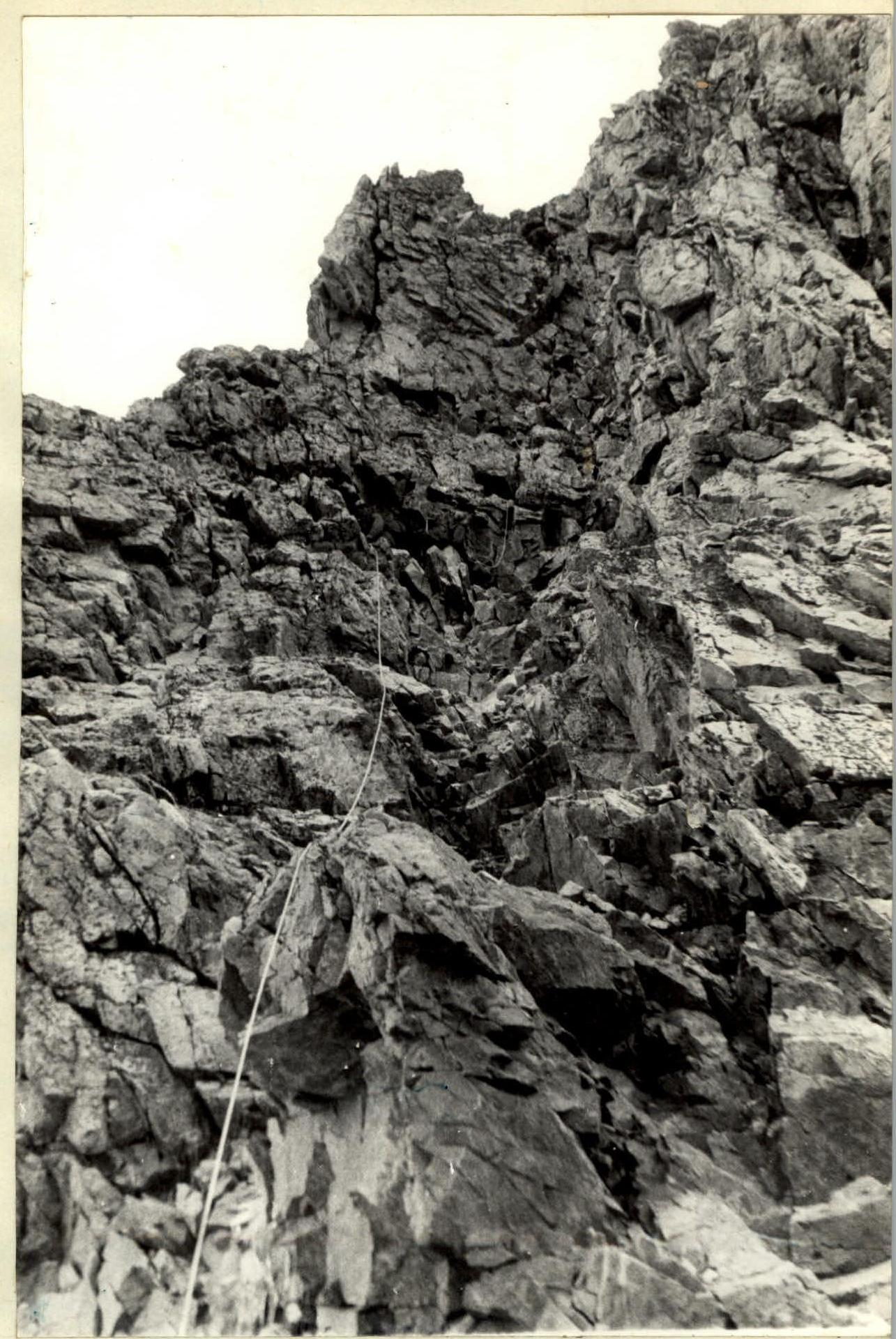
12:00. Weather worsens, strong gusts of wind. Ascent to Central Shkhelda initially goes along a steep couloir south of the ridge (60 m), belay via pitons, steepness 60-70°. Exit to the ridge on the left: 20 m along it, then along a ledge to the right with an exit to a small snow ledge (1.5 ropes), belay via outcrops and pitons. From the ledge, the ascent goes (60 m) along a steep, icy couloir - glacial ice, belay via pitons, steepness 60-80°. The couloir ends with rocks of medium difficulty, which lead to the ridge. The path along the ridge is initially not complicated, belay via outcrops. Further ascent leads to a small platform, from which the path goes under an overhanging rock to the right, into a couloir, the passage is quite difficult (3 m). Further, the path goes into a steep, icy couloir (about 60 m), belay via pitons, steepness 60-80°. Then along rocks of medium difficulty (40 m) to the beginning of the pre-summit ridge, which consists of destroyed rocks.
15:30. We reach the summit. We set up a bivouac just below the summit. At 18:00, we establish communication with observers and the camp.
August 13 - 2nd day of traverse
4:00. Weather has deteriorated. Distant thunder rumbles, hurricane-force wind blows, air is humid, rocks are covered with frost. We hold the tent to prevent it from being torn apart.
9:00. Visibility is almost zero, wet snow is falling.
18:00. Two people go out to make contact with the ridge. Communication is excellent. We request a weather forecast for August 15 and schedule a communication session for August 15 at 10:00. The weather remains unchanged.
August 14 - 3rd day of traverse
10:00. The weather has not changed. Still the same as yesterday. We make contact. Communication is excellent. We talk to the camp and observers. They provide a weather forecast, which is not encouraging. They predict prolonged bad weather.
18:00. The weather is improving: the wind is still strong, but dry, blowing snow off the rocks. In the gaps between clouds, blue sky is visible. We make contact, learn that the barometer is rising. For the second day, every 1.5 hours we jump out of the tent and, attached to the railing, do gymnastics to avoid relaxation.
August 15 - 4th day of traverse
9:00. The weather has improved. A strong wind blows, very cold. In the gaps between clouds, the sun occasionally appears. We continue the traverse, descending from Central Shkhelda to a small saddle. The rocks in this section are fragile, the descent is made by rope (40 m into a hollow). From the saddle, the ascent goes along a wall 20 m, then along a ledge to the south (80 m), with an exit to the ridge (belay via pitons and outcrops, wall steepness 70°). We begin the descent, not reaching the ridge by 20 m. There are wide intermediate platforms on the descent.
1st descent - 40 m, 2nd descent - 40 m, leads to a saddle between Central Shkhelda and Eastern Shkhelda.
13:30. Cold weather, strong wind.
We clear the platform from ice, set up a tent.
A pair, warming up, starts processing the ascent to Eastern Shkhelda.
18:00. We make contact. Communication is excellent with both the observation group and the camp.
August 16 - 5th day of traverse
6 hours 00 minutes. Weather: cloudy, strong cold wind blows. Movement along the saddle is made bypassing "dzhendarms" from the south along ice and rocky ledges (4 ropes). The ascent to Eastern Shkhelda is quite difficult. The ascent initially goes along a snow-rock ridge to a small wall (2.5 ropes), belay via pitons and outcrops, steepness 40-60°. The wall (3 m) is bypassed on the left along a crevice. Then 40 m along the wall straight up, belay via pitons, steepness 60-90°. Then 10 m along a couloir and a ten-meter wall, steepness 70-90°, belay via pitons. After passing the wall, we again enter a couloir leading to a narrow ledge. Movement along the ledge requires careful belay via pitons. Moving along the ledge to the right, we reach a 5 m high crevice. Belay via pitons, steepness 60-70°. After ascending the crevice, we reach the ridge. Further along the ridge to the very summit, belay via outcrops.
14:15. From the summit, we give a green flare to observers.
14:30. We begin the descent from Eastern Shkhelda:
- Initially along a rope to the ridge (4 m),
- then bypassing the "table" along a ledge,
- further along the ridge of a steep cliff,
- to the descent along the wall.
1st descent - 40 m, 2nd descent - 40 m, 3rd descent - 20 m.
3rd descent leads to an inclined ledge (20 m), which goes up to the rock "PETUKH" (Rooster).
15:00.
The ascent to "Petukh" goes along rocks of medium difficulty (25 m), followed by a descent by rope (about 80 m) to the south.
After descending from "Petukh" to the ridge, we continue moving along it on the right side (in the direction of travel).
We lay out "sports" descents of 5 × 45 m down to the overnight stay under the wall.
18:00. We establish communication with observers. We set up a bivouac.
August 17 - 6th day of traverse
5 hours 30 minutes. The weather has noticeably improved, but a gusty wind blows. We begin the descent towards Shkheldinskaya "Pila" (Saw), crossing several icy couloirs towards the "Garf's saddle". Further movement goes along the southern talus slopes of Shkheldinskaya "Pila".
12:00. We reach the pass, where a large cache is laid. We change equipment for further traverse.
August 18 - 7th day of traverse
4 hours 30 minutes. Weather: fog, strong wind, cold. From the Ushba plateau, we ascend to the "cushion". The ascent to it is made on crampons along dense firn.
7 hours 15 minutes. After a short rest, we begin the ascent to "Nastenko Rocks" (80 m), belay via ice screws.
"Nastenko Rocks":
- Loose, not difficult.
- Passed with piton belay (60 m).
From "Nastenko Rocks", the ascent goes along a steep ice slope with step cutting, belay via pitons.
11 hours 30 minutes. We move further along the ridge of North Ushba. To the southeast, snow cornices overhang the ridge. In some places, we have to cut steps in the ice. The last ascent of the ridge leads to the summit. 15:00. The summit is a snow ridge with an overhanging cornice.
15:30. We begin the descent to the saddle along rocks of medium difficulty. The descent is made "sporting way" (5 ropes). Belay via outcrops.
17:00. We clear the platform from ice, set up a bivouac. 18:00. We contact observers by radio. At night, the wind blows with such force that we recall that "Ushba" translates to Russian as "Witch".
August 19 - 8th day of traverse
8:00. Weather: cold, strong wind, cloudy. We reach the saddle between North and South Ushba initially along a snow-ice ridge (on crampons) (one rope), belay via ice axe. Bypassing the first "dzhendarms", we ascend to the second. The exit is icy, we cut steps. The second "dzhendarms" is bypassed on the right side. The further path goes along the "knife-edge" to the southern wall (80 m). The "knife-edge" has large cornices, belay via ice axe.
10:00. We begin the ascent to South Ushba along a rocky couloir (7-8 m) filled with ice in the lower part. Belay via pitons, steepness 60°. After about 70-80 m of ascent, we reach slab-like rocks. The slab is one of the most difficult parts of the ascent to South Ushba. The height of the slab is about three meters (steepness 90°), belay via pitons, backpacks are pulled up. Traversing the slab to the right along rocks of medium difficulty (40 m), we enter a rocky couloir. The couloir, with protruding rock fragments, leads under a wall 20-25 m, steepness 70-80°, belay via pitons. The wall is passed by normal climbing and leads to the "crown" of South Ushba. Further movement goes along a snow ridge with rocky outcrops. Belay via ice axe and pitons (4 ropes).
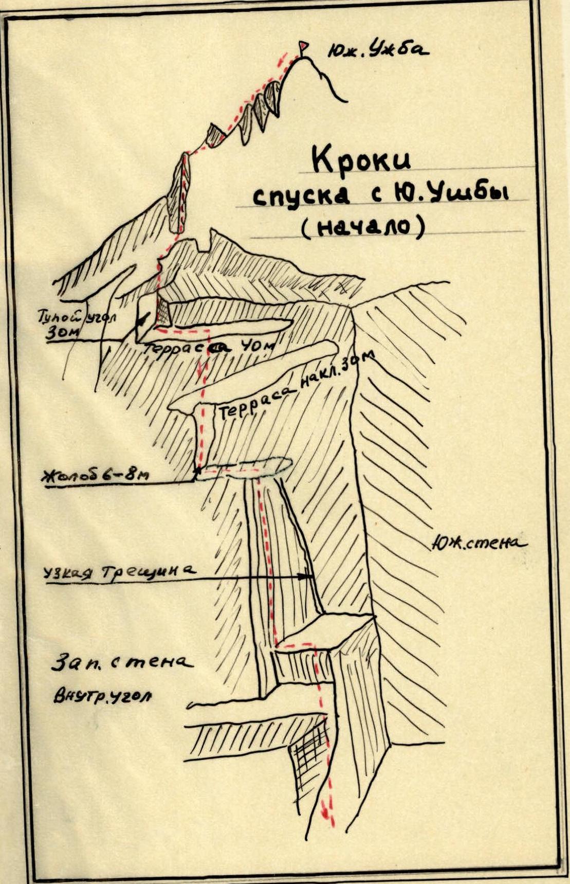
15:00. We are on the summit. Windy, cloudy. We leave a note and begin the descent along the right rocky ridge. Movement with simultaneous belay.
16:30. Clear weather. We set up a bivouac before the "dulfy" (rappel).
18:00. We contact observers and the camp.
August 20 - 9th day of traverse
8:00. Clear weather, cold, light wind. The first descent by rope, about 35-40 m, leads to a narrow ledge, which we traverse to the right for 2-3 m. The second descent is steeper than the first (40 m) and leads to a not very wide, long ledge (15-20 m). Another "dulfy" descent, and we are on a rocky ridge leading to the "red angle". Several descents "sporting way" and we are on the platforms of the "red angle".
14:30. Bivouac at the "Red Angle". Further movement is impractical due to rockfall.
August 21 - 10th day of traverse
4 hours 30 minutes. Excellent weather. Further descent goes along stepped "ram's foreheads". We quickly hang loops and organize descents "sporting way".
6 hours 00 minutes. We cross the icy "galstuk" (neck) with step cutting in its narrowest part. Then we begin the ascent along rocks to "Mather's tooth" - rocks of medium difficulty (80 m), belay via pitons.
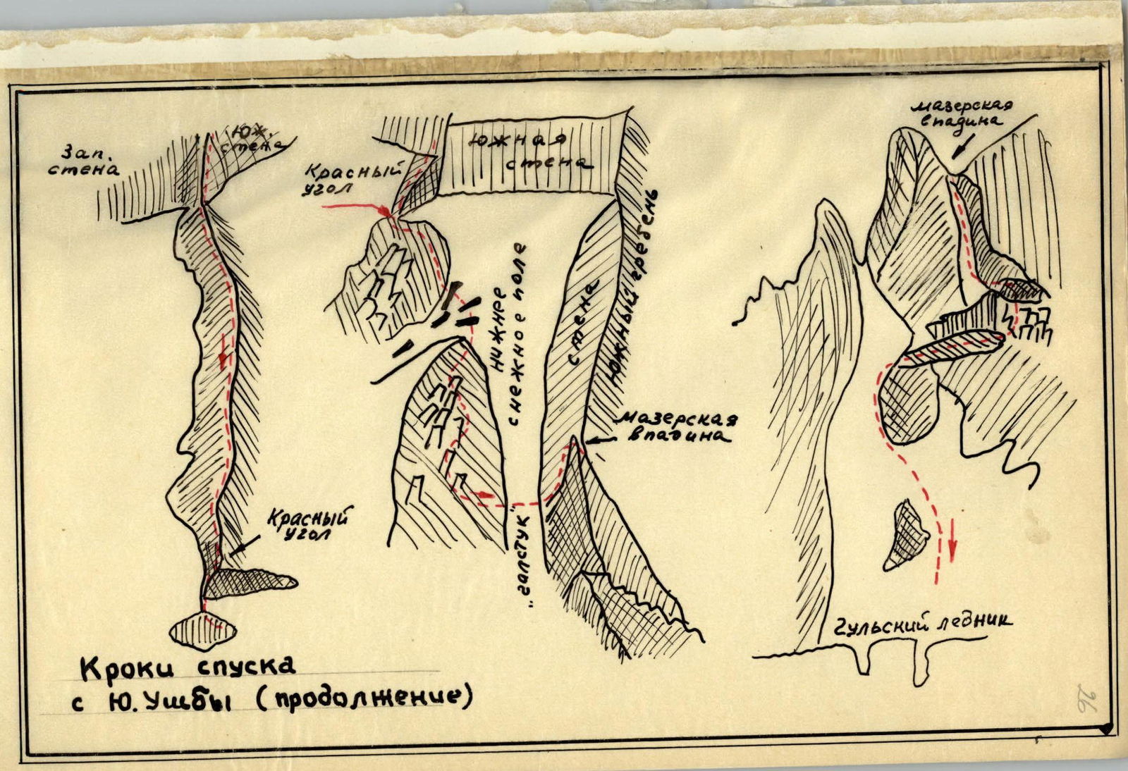
7:00. Descent from the "tooth" along a rocky, strongly destroyed couloir is made sporting way, about 330 m. Further descent leads to the moraines of the Gульский glacier (Gulsky glacier). Another half hour of walking, and we are on the long-awaited grass.
17:00. Bivouac on the "Shikhra" clearing.
18:00. Communication with the camp and observers.
August 22
6:00. Excellent weather, warm.
During the morning communication with the camp, we order a car for 17:30.
We walk along the trail of the Dolra valley.
14:00. Becho pass is behind us, further path is to the Baksan valley.
18:00. The team returned to the "Adyl-Su" alpine camp.
Characteristics of the group members
The traverse of Shkhelda-Ushba massifs with ascent via the northern wall to the 3rd Western Shkhelda showed that the group is fully prepared to make an ascent of this complexity. The participants have sufficient organizational and tactical experience, are well-trained to pass very difficult rocky and icy sections of the route. During the traverse, there were no drop-offs or other emergencies.
Shulgin Yu.P. - well-prepared physically and technically. Engaged in mountaineering for 16 years, has accumulated extensive experience in complex ascents. Very efficient.
Polyakov S.I. - excellent rock climber, confidently and reliably leads.
Yushkevich V.S. - physically and technically well-prepared. Quickly orients and chooses a path on the route. Reliable as a leader.
Zherdev V.S. - well-prepared mountaineer. Can work well as a leader and last man.
Team leader
/ Konkov / 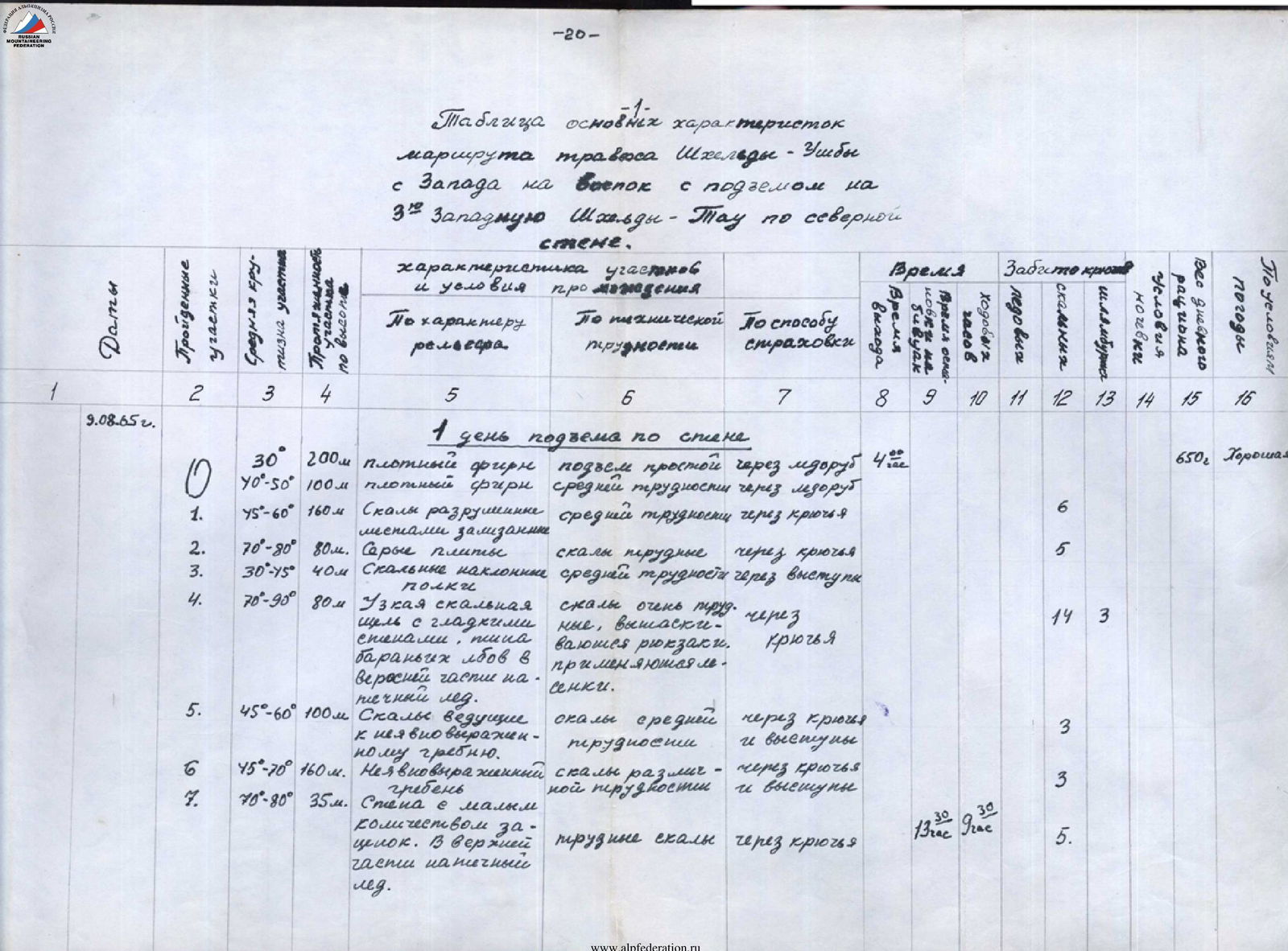
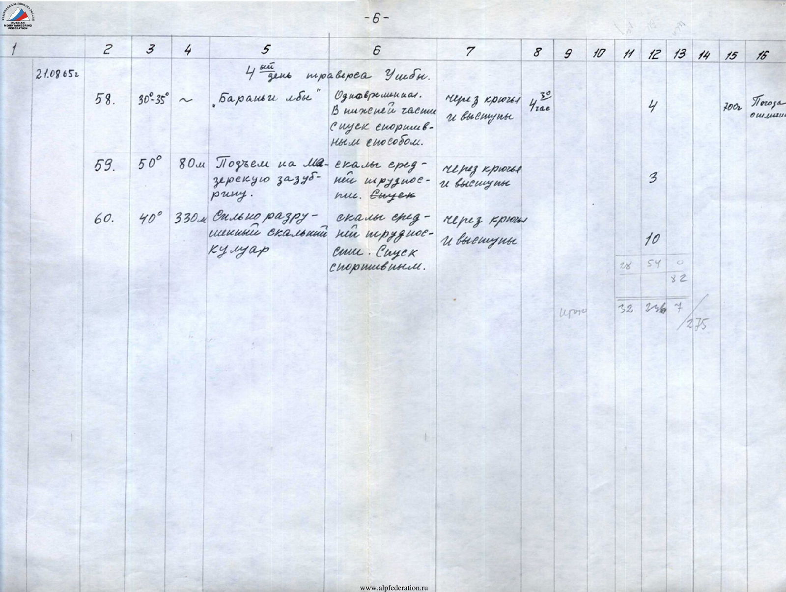
Table of main characteristics of the Shkhelda-Ushba traverse route from West to East with ascent to the 3rd Western Shkhelda-Tau via the northern wall
| Dates | Section | Average steepness of the section, ° | Height gain, m | By relief character | By technical difficulty | By belay method | Movement time, h | Pitons, pcs | Shoulder pitons, pcs | Ladders, pcs | Note |
|---|---|---|---|---|---|---|---|---|---|---|---|
| 1st day of ascent up the wall | |||||||||||
| 09.08.1965 | R0 | 30 | 200 | dense firn | ascent is simple | via ice axe | 4 | 650 g. Excellent | |||
| 40–50 | 100 | dense firn | of medium difficulty | via ice axe | |||||||
| R1 | 45–60 | 160 | Rocks are destroyed, местами smoothed | of medium difficulty | via pitons | 6 | |||||
| R2 | 70–80 | 80 | Gray slabs | rocks are difficult | via pitons | 5 | |||||
| R3 | 30–45 | 40 | Rocky inclined ledges | of medium difficulty | via outcrops | ||||||
| R4 | 70–90 | 80 | Narrow rocky crevice with smoothed sides, like "ram's foreheads", with glacial ice in the upper part | rocks are very difficult, backpacks are pulled up, ladders are used | via pitons | 14 | 3 | 3 | |||
| R5 | 45–60 | 100 | Rocks leading to an indistinctly expressed ridge | of medium difficulty | via pitons and outcrops | 3 | |||||
| R6 | 45–70 | 160 | Indistinctly expressed ridge | rocks of varying difficulty | via pitons and outcrops | 3 | |||||
| R7 | 70–80 | 35 | Wall with a small number of holds. In the upper part - glacial ice. | difficult rocks | via pitons | 5 | |||||
| 2nd day of ascent up the wall | |||||||||||
| 10.08.1965 | R8 | 40–50 | 40 | Rocks | of medium difficulty | via pitons and outcrops | 2 | 2 | Weather is satisfactory. Light wind. Cold in the morning. | ||
| R9 | 60–90 | 45 | Rocky spine | difficult rocks | via pitons | 10 | |||||
| R10 | 50–60 | 80 | Icy slope with rocky islands | difficult section | via pitons | 6 | 2 | ||||
| R11 | 60 | 80 | Strongly destroyed rocks | of medium difficulty | via pitons and outcrops | 3 | |||||
| R12 | 60–90 | 40 | Stepped rocky wall | difficult rocks | via pitons | 8 | |||||
| R13 | 40–50 | 20 | Icy slope | of medium difficulty | via pitons | 1 | |||||
| R14 | 60 | 40 | Rocky ridge | difficult rocks | via pitons | 5 | |||||
| R15 | 75–90 | 40 | Indistinctly expressed inner corner | rocks are very difficult. Backpacks are pulled up, a 10-meter section is passed on ladders | via pitons | 18 | 18 | 2 | |||
| 3rd day of ascent up the wall | |||||||||||
| 11.08.1965 | R16 | 60 | 40 | Icy slope | overcome with step cutting | via pitons | 4 | 1 | 650 g. Clear, strong wind. | ||
| R17 | 60–80 | 160 | Rocks are snow-covered, местами glacial ice. | Due to glacial ice, movement is very difficult. | via pitons | 13 | 24 | ||||
| 1st day of Shkhelda traverse | |||||||||||
| 12.08.1965 | R18 | 80 | 40 | Descent | sitting on a rope | via pitons | 2 | Cloudy, strong wind. | |||
| R19 | 80–90 | 35 | Descent | sitting on a rope | via pitons | ||||||
| R20 | 80–90 | 20 | Descent | sitting on a rope | via pitons | ||||||
| R21 | 80 | 40 | Descent | sitting on a rope | via pitons | ||||||
| R22 | 60–70 | 60 | Wide rocky couloir | rocks of medium difficulty | via pitons | 5 | |||||
| R23 | 60–80 | 60 | Icy couloir | difficult rocks | via pitons | 6 | |||||
| R24 | 50 | 40 | Rocky ridge | of medium difficulty | via pitons and outcrops | 2 | |||||
| R25 | 70 | 40 | Couloir with glacial ice | rocks of medium difficulty | via pitons | 5 | |||||
| R26 | 50 | 40 | Pre-summit ridge | rocks of medium difficulty | via pitons and outcrops | 15 | 2 | ||||
| 2nd day of Shkhelda traverse | |||||||||||
| 15.08.1965 | R27 | 70 | 40 | Wall | descent sitting on a rope | via pitons | 9 | 2 | Weather has improved, strong wind blows, very cold. | ||
| R28 | 60 | 20 | Rocky spine | rocky spine, movement is complicated by snow-covered rocks | via pitons and outcrops | 3 | |||||
| R29 | 60 | 80 | Descent | sitting on a rope | via pitons | 13 | 2 | ||||
| 3rd day of Shkhelda traverse | |||||||||||
| 16.08.1965 | R30 | 60 | 160 | Rocks, ice bypassing "dzhendarms" | of medium difficulty | via pitons and outcrops | 6 | 6 | Cloudy, strong cold wind. | ||
| R31 | 40–60 | 100 | Snow-rock ridge | of medium difficulty | via pitons and outcrops | 4 | |||||
| R32 | 60–90 | 40 | Rocky crevice | difficult section | via pitons | 6 | |||||
| R33 | 60–70 | 20 | Couloir turning into a spine | difficult rocks | via pitons | 4 | |||||
| R34 | 60–70 | 15 | Ledge leading to a crevice | difficult rocks | via pitons | 3 | |||||
| 4th day of Shkhelda traverse | |||||||||||
| 17.08.1965 | R35 | 30 | 120 | Descent along a destroyed ridge | easy rocks | simultaneous, via outcrops | Clear, strong wind. | ||||
| R36 | 80 | 100 | Wall | descent sitting on a rope | via pitons | ||||||
| R37 | 30 | 20 | Inclined ledge | easy rocks | via pitons | ||||||
| R38 | 40 | 25 | Ascent to "Petukh" | rocks of medium difficulty | via outcrops | ||||||
| R39 | 45 | 80 | Rocks | descent sporting way | via pitons | 3 | |||||
| R40 | 50–60 | 220 | Large rocks | descent sporting way | via pitons | 18 | 3 | ||||
| 1st day of Ushba traverse | |||||||||||
| 18.08.1965 | R41 | Exit to Ushba pass along southern talus slopes of "Pila" in Shkheldy-Tau | 4 | Fog, strong wind, cold. | |||||||
| R42 | 30–40 | Dense firn | slopes are easy | via ice axe | 4 | ||||||
| R43 | 45–50 | 80 | Icy slope | partially step cutting | via pitons | 4 | |||||
| R44 | 50 | 60 | "Nastenko Rocks" | of medium difficulty | via pitons and outcrops | 3 | |||||
| R45 | 45 | 300 | Icy slope | step cutting | via pitons | 18 | 18 | ||||
| R46 | 30–60 | Ice-firn ridge with cornices | местами requiring step cutting | via pitons and ice axe | 3 | ||||||
| R47 | 30–40 | 300 | Descent from North summit along destroyed rocks | descent sporting way | via outcrops | 17 | |||||
| 2nd day of Ushba traverse | |||||||||||
| 19.08.1965 | R48 | 30–35 | "Ram's foreheads" | simultaneous. In the lower part, descent sporting way. | via pitons and outcrops | 3 | 4 | Excellent weather. | |||
| R49 | 50 | 80 | Ascent to "Mather's tooth" | rocks of medium difficulty | via pitons and outcrops | 3 | |||||
| R50 | 40 | 330 | Strongly destroyed rocky couloir | rocks of medium difficulty | via pitons and outcrops | 10 |
Profile of the northern wall ascent of the 3rd Western Shkhelda ("Rybka") 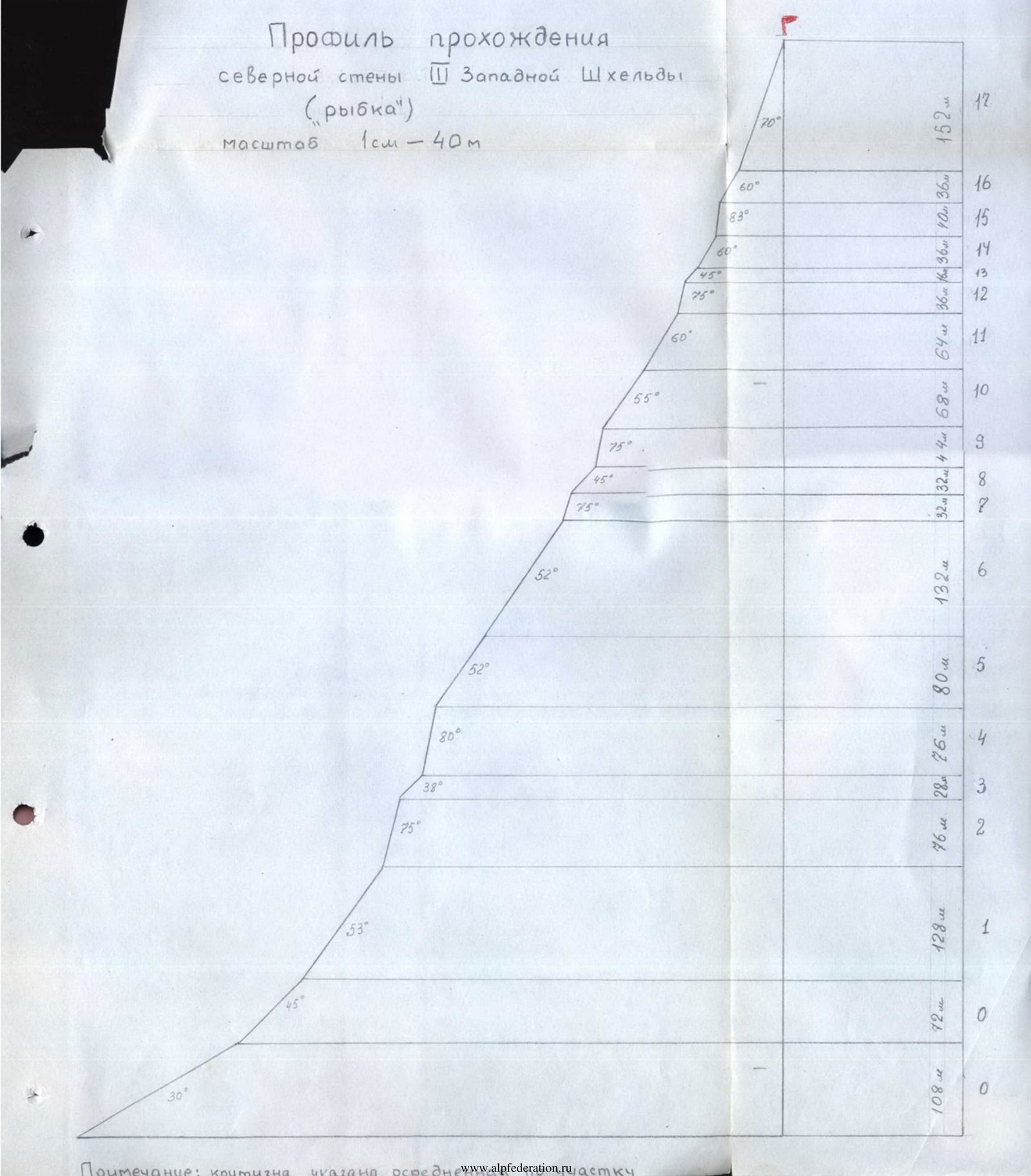
Conclusion
A fourteen-day traverse of Shkhelda-Ushba peaks with ascent via the northern wall to the 3rd Western Shkhelda has been completed. This ascent combined two routes of the highest difficulty category:
- Technically complex wall route (ascent to the 3rd Western Shkhelda by "Rybka").
- Long traverse of Shkhelda-Ushba peaks, about 8 km long. "Rybka" is a very interesting and diverse route that requires climbers to master the entire arsenal of modern mountaineering techniques. Significant (1.5 km) height difference and steepness place serious demands on the physical and mental preparation of climbers. This wall, in our opinion, is much more complex than routes such as ascent to Eastern Shkhelda-Tau cat. diff. 5A, to Central Shkhelda (by "lopata" cat. diff. 5B), which were passed by team members in 1962-1964.
The complexity of the Shkhelda-Ushba peaks traverse is widely known. Additional difficulties were created by bad weather conditions.
The traverse passed the following peaks:
- 3rd Western Shkhelda-Tau (4229 m)
- Central Shkhelda-Tau (4295 m)
- Eastern Shkhelda-Tau (4320 m)
- North Ushba (4695 m)
- South Ushba (4170 m)
Year-round training, extensive experience of joint ascents, well-developed organizational and tactical plan of the traverse, proper organization of food and rest on the route, excellent selection of equipment, team cohesion allowed to successfully complete the ascent up the wall to the 3rd Western Shkhelda and further traverse the peaks of Shkhelda-Ushba within the timeframe set by the plan, in complex meteorological conditions.
Ascent to Central Shkhelda (sections R22-R23) ![img-9.jpeg]({"width":1159,"height":3174,"format":"Jpeg","uri":"