Climbing Passport
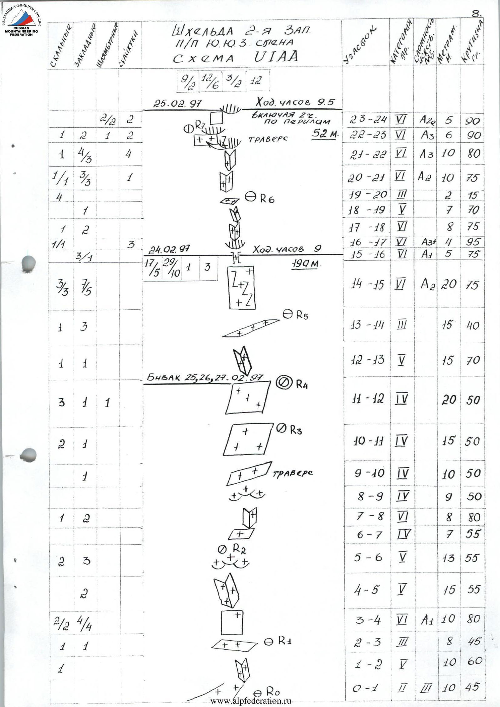
I. Winter category. 2. Central Caucasus. 3. Shkhelda 2nd Western peak (4310) via the black stream on the South-Southwest wall through the cornices. 4. Proposed - 6A category of difficulty, first ascent. 5. Height difference: 550 m (350 m of wall and 200 m of roof); length - 985 m (450 m of wall), 5-6 category of difficulty - 350 m. Length of sections with 5th category of difficulty - 90 m; 6th - 259 m. Average steepness of the main part of the route - 73°. 6. Pitons driven: rock, nuts, bolt hangers, skyhooks
| 49 | 114 | 12 | 35 |
|---|---|---|---|
| 19 | 85 | 5 |
Left on the route: rock - 2; nuts - 0; bolt hangers - 10. 7. Team's climbing hours: 54 and days 6. 8. Overnights: 1st - under a cornice on a snowdrift; 2nd - on a rock ledge in the upper part of the wall; 3rd - under the pre-summit ridge on the descent. 9. Team leader: Koshelenko Yuri Vladimirovich MS 344092 Rostov-on-Don, Startovaya, 2, apt. 4 Team members:
- Polokhov Vitaly Fedorovich MS
- Nikitenko Viktor Borisovich MS
- Astakhov Mikhail Valentinovich MS
- Popov Anatoly Albertovich CMS
- Knyazhev Alexey Vladimirovich MS
- Coach: Pogorelov Alexander Grigorievich MSIC 344029 Rostov-on-Don, Lenina, 251, apt. 68
- Approach to the route: February 24, 1997. Reached the summit: March 1, 1997; returned to the base camp: March 3, 1997.
- Federation of Alpinism and Rock Climbing of the Rostov region (344028, Rostov-on-Don, 1st Konnaya Army str., 4).
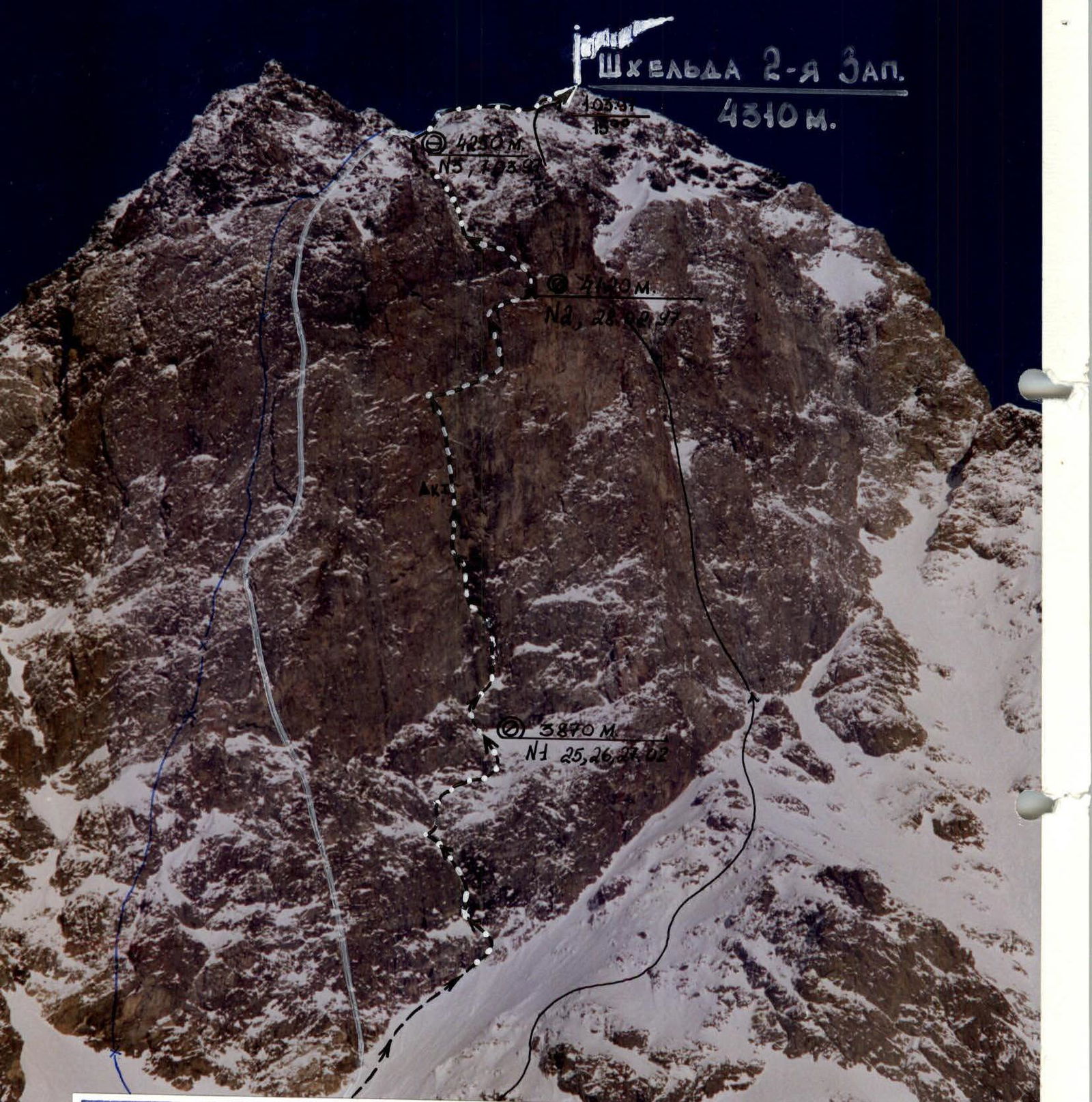
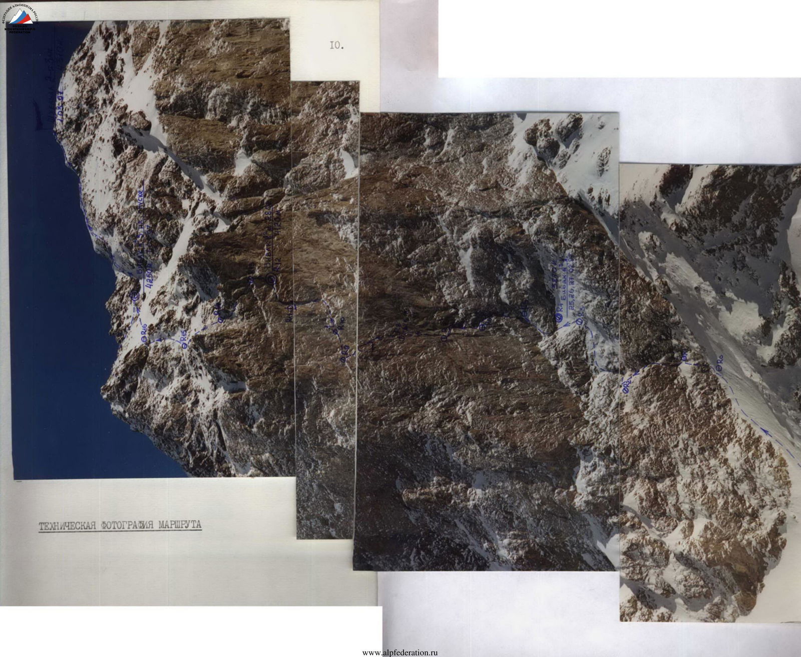
Photo 1. General photo of the summit. February 24, 1997.
- V. Kuznetsov's route on the SW wall, 5B, 1969.
- O. Akhtyrsky's route on the S wall, 5B, 1974.
- S. Drobot's route on the center of the S wall, 5B, 1977.
- Team's route.
Brief Overview of the Climbing Area
Shkhelda is a well-known mountain massif among climbers, especially its North wall. However, its southern side is not as familiar to many. The Ushbinsky and South-Shkheldinsky glaciers flow along the southern walls and slopes of the massif. Routes on its peaks from the south are generally of medium difficulty, with the exception of the 2nd Western Shkhelda. Unlike its sisters, which have relatively gentle and destroyed ridges and slopes to the south, it rises with a steep rock wall above the cirque formed by itself, the 1st Western Shkhelda, Profsoyuzov peak, Fizkulturnik peak, and the southern spur of the Main Caucasian Ridge.
The wall was first explored by Rostov climbers in 1969 (V. Kuznetsov's route, 5B category of difficulty, on the left side of the Left bastion of the SW wall).
In the mid and late 1970s, two more routes were established:
- in 1974, O. Akhtyrsky - 5B category of difficulty on the Right bastion of the S wall;
- in 1977, S. Drobot - on the right side of the Left bastion of the SW wall.
After that, this wall was seemingly forgotten for a long time, and the central, steepest bastion with a black stream remained unclimbed.
This bastion deserves special attention and, despite not having a very large height difference, approximately 330-350 m, is very interesting from a technical point of view. As V. Nikitenko, who led on the first day of the ascent, said: "Don't think it's easy, it's 'Karavshin' there." The middle and upper parts of the wall feature:
- almost constant overhangs
- cornices
The route "pulls" towards a small 6B category.
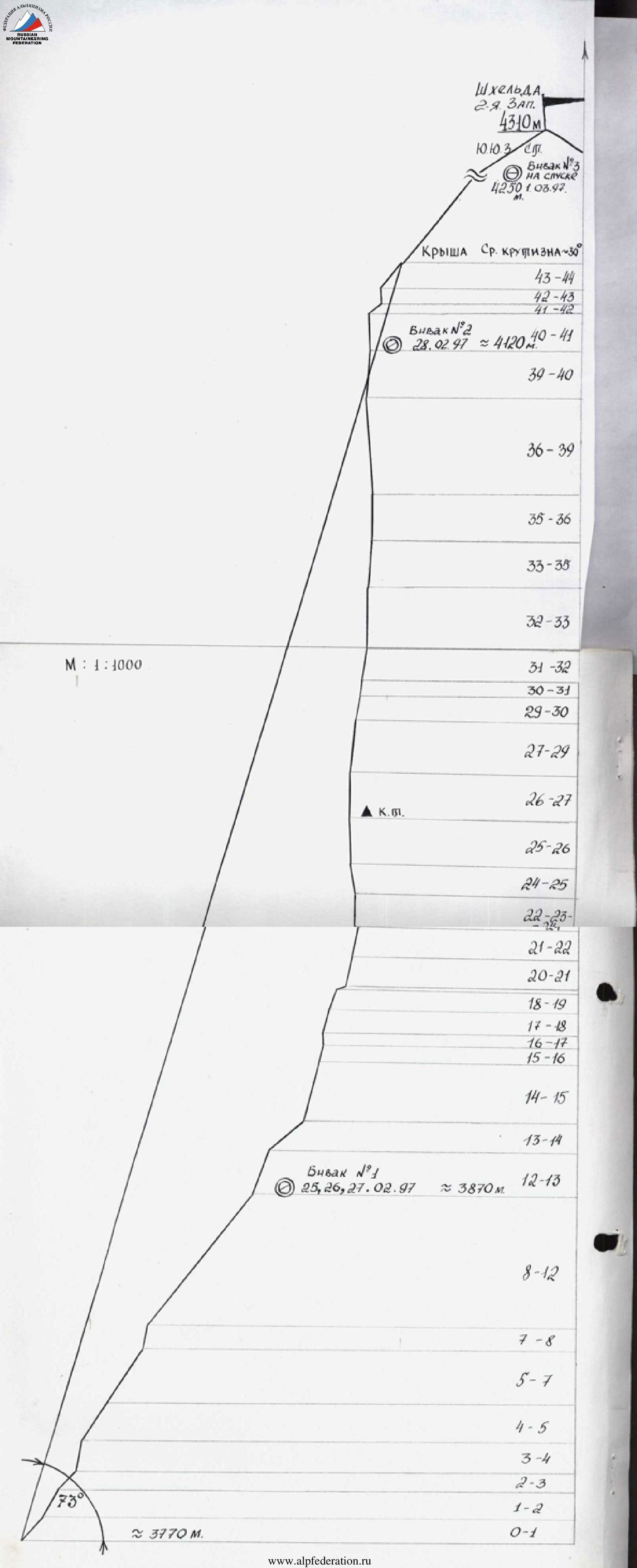
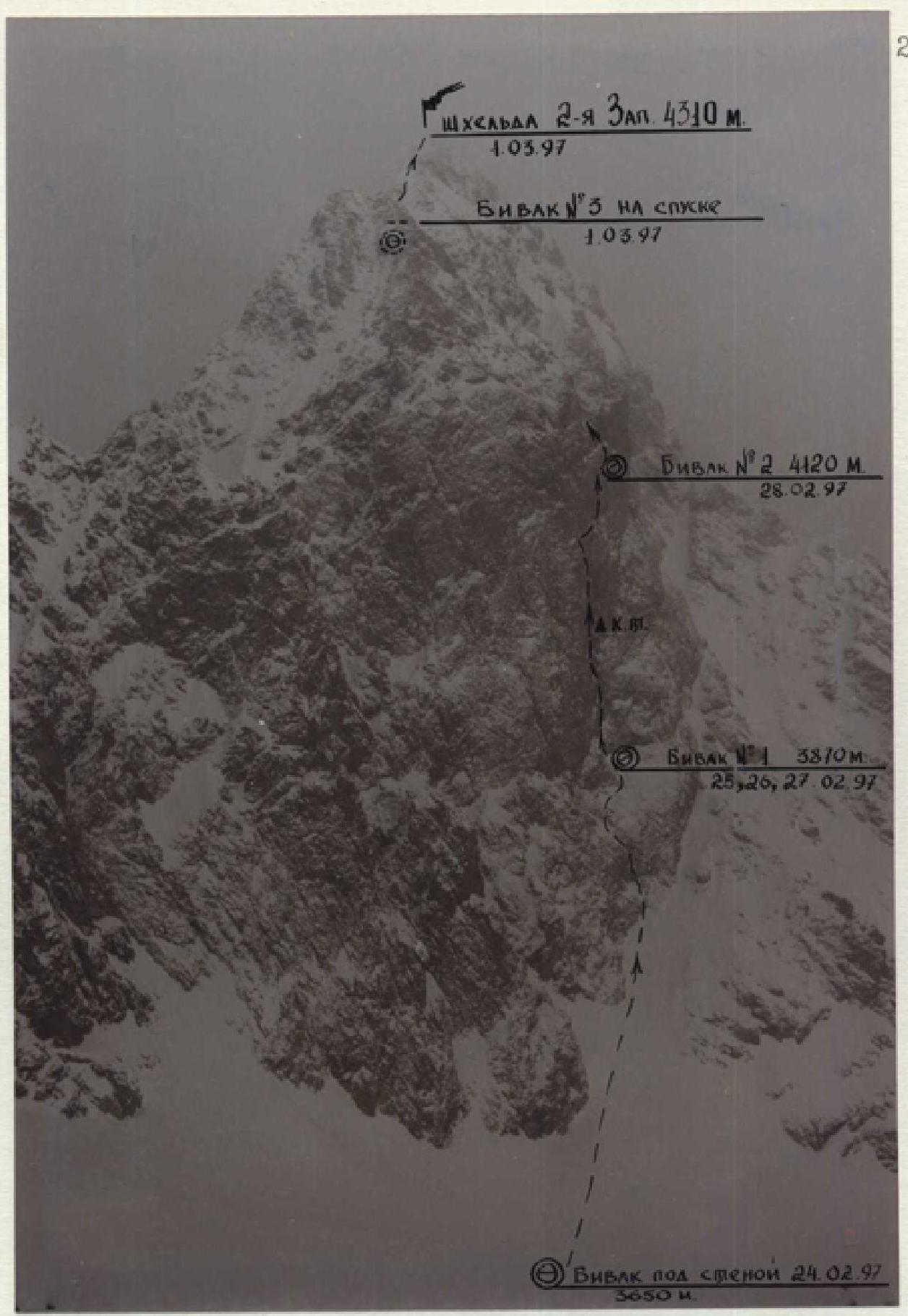
Photo 2. Wall profile from the left. February 23, 1997, 16:30. Shooting point - Kurсантov pass. Team's route.
Tactical Actions of the Team
The plan for this climbing cycle was multi-variant and complex. It was built considering several factors, including:
- ice conditions of the objects;
- unstable weather in late February.
The team acted strictly according to this plan.
Object #1 was the NW wall of S. Ushba, with two options for first ascents planned:
- Option 1 via the NW wall of S. Ushba;
- Backup option - Myshlyaev's route on S. Ushba, in case the ice condition on the NW wall differed from our assumptions.
Object #2, in case of a prolonged period (more than 2 days) of bad weather at the beginning of the climbing cycle, was the S, or more precisely, the SSW wall of the 2nd Western Shkhelda, its central, overhanging bastion with a black stream in the middle.
This wall caught our attention for several reasons:
- due to its undoubted steepness and complexity (very similar to Chatyn's Rhombus);
- its center had not been climbed yet;
- it fit well into our tactical plan;
- maintaining tradition, since its exploration belongs to Rostov climbers: Kuznetsov, Artsishevsky, Manshin (1969);
- the wall is not well-known and deserves more attention.
Having set out on February 20, 1997, from the Elbrus UMMC base, we spent the night under the Sredny pass in a pre-dug cave. The weather started to deteriorate in the second half of the day.
February 21, 1997. We crossed the Sredny pass and descended to the Kurсантov pass via Fizkulturnik peak. We couldn't see either of our objects due to practically zero visibility. It was decided to descend closer to our main object, v. Ushba, marking our descent with the wands we had, as we planned to start climbing on February 22, 1997. After the visibility worsened further, we stopped and spent the night under the slopes of Ts. Shkhelda.
February 22, 1997. A rest day due to complete lack of visibility (snowstorm).
February 23, 1997. Slight improvement in weather. It was decided to work according to the previously approved plan and ascend back under the S wall of the 2nd Western Shkhelda. Since most team members had snowshoes, it significantly eased movement through the fresh snow. Bivouac under the SSW wall of the 2nd W. Shkhelda.
February 24, 1997. Clear, good weather. Work started at 8:00, finished at 17:00. The 1st day of ascent was combined with refining the intended route and detailing the tactics for passing certain sections. The lower third of the wall, which visually seemed not very complex, turned out to be much steeper than we assumed. Empty snow on steep slabs required careful climbing in crampons and thorough belaying. On the first day, 190 m of the wall were climbed, and a bivouac site was scouted.
February 25, 1997. Work started at 8:00, finished at 17:30. The rope team worked under the cornice, while the rest of the group arranged a bivouac on a ledge. It involved very complex free climbing and artificial technical climbing (I.T.O.), with extensive use of skyhooks for moving across the terrain. Organizing reliable belays required a lot of ingenuity. Under the cornice, there were many loose fragments and blocks. The belay station under the cornice was set on a "Spit Petzh" bolt.
February 26, 1997. Work started at 8:00, finished at 17:00. The rope team worked on the cornice. While ascending, they straightened and, in some places, changed the fixed ropes. The cornice is a key section of the route, very complex I.T.O. on live fragments and blocks of the overhang. To ensure reliability of the belay under the cornice, 2 bolt hangers were driven. The station was on a "Spit Petzh" bolt, where a "control tour" was later left.
February 27, 1997. Work started at 8:00, finished at 17:30. A complex section was passed (I.T.O., skyhooks) with a general direction to the left. Also, a traverse to the right was made on steep slabs using skyhooks (2nd key point). It was a very cold day.
February 28, 1997. Work started at 8:00, finished at 18:00. By the second half of the day, we passed the so-called "trough" with three tiers of cornices and scouted a ledge in its upper right part. (The ledge was visually identified during route planning). At 15:00, we walked away from the route, started transferring the bivouac, and retrieved the fixed ropes. The weather deteriorated sharply. The leading rope team finished the wall and reached the roof that day.
March 1, 1997. Work started at 8:00, reached the summit at 15:00. In poor weather conditions - low visibility and strong wind - the group climbed several rope lengths on the roof, set up a bivouac under a gendarme on the pre-summit ridge, and ascended to the summit of the 2nd Western Shkhelda by 15:00. No control tour or note was found. After a long search, they built their own control tour, into which they placed a note about the ascent in a plastic bag.
March 2, 1997. Descended from the summit first along the ridge, then to the left via a couloir: 7-8 rappels. And further down a snowy couloir to the base of the wall. The return route was planned via the Biivachny pass, which was considered shorter. By 19:00, they were back in the cave on the North side.
March 3, 1997. Descent to the base at UMMC "Elbrus".
Thus, the entire trip took 12 days, 6 of which were spent climbing from February 24, 1997, to March 1, 1997. Work on the route was done with a change of lead and was distributed as follows:
- Nikitenko V.B.: R0–R12
- Astakhov M.V.: R12–R16
- Polokhov V.F.: R24–R27, R33–R45
- Koshelenko Yu.V.: R16–R24, R27–R33, R45–R49
The first worked on a double UIAA rope (50 m). Fixed ropes were passed with belay.
From the technical equipment, we highlight:
- a set of soft friends;
- thin ice axes for deep cracks;
- micro nuts;
- "Spit Petzh" bolts for stations and 8 mm for belay and progression;
- "Petzl" equipment;
- slings from "Petzl" and "VAUDE".
Belay was done through a "bukashka" or a figure eight. There were no falls on the route. Belay points were organized:
- on 3-4 blocked points;
- on "Spit" bolts (very hard granite).
The route, despite not being very long, turned out to be highly technically complex and requires a good level of technical skills, corresponding to 6B category of difficulty.
A "Yefimov's" high-altitude tent was used during the ascent, which proved to be very good. Bivouacs #1 and #2 on the wall were semi-reclined. Bivouac #3 on the roof was reclined.
Radio communication with "Luch" (KSP) was maintained using the support group: senior coach Pogorelov A.G., doctor Karbyshev G.L., who set up on the moraine of the Akh-su glacier on the north side of p. "Sredny". "Kaktus" KSP radio stations were used. The communication was reliable, without interruptions or breaks.
- senior coach Pogorelov A.G.
- doctor Karbyshev G.L.
- "Kaktus" KSP radio stations
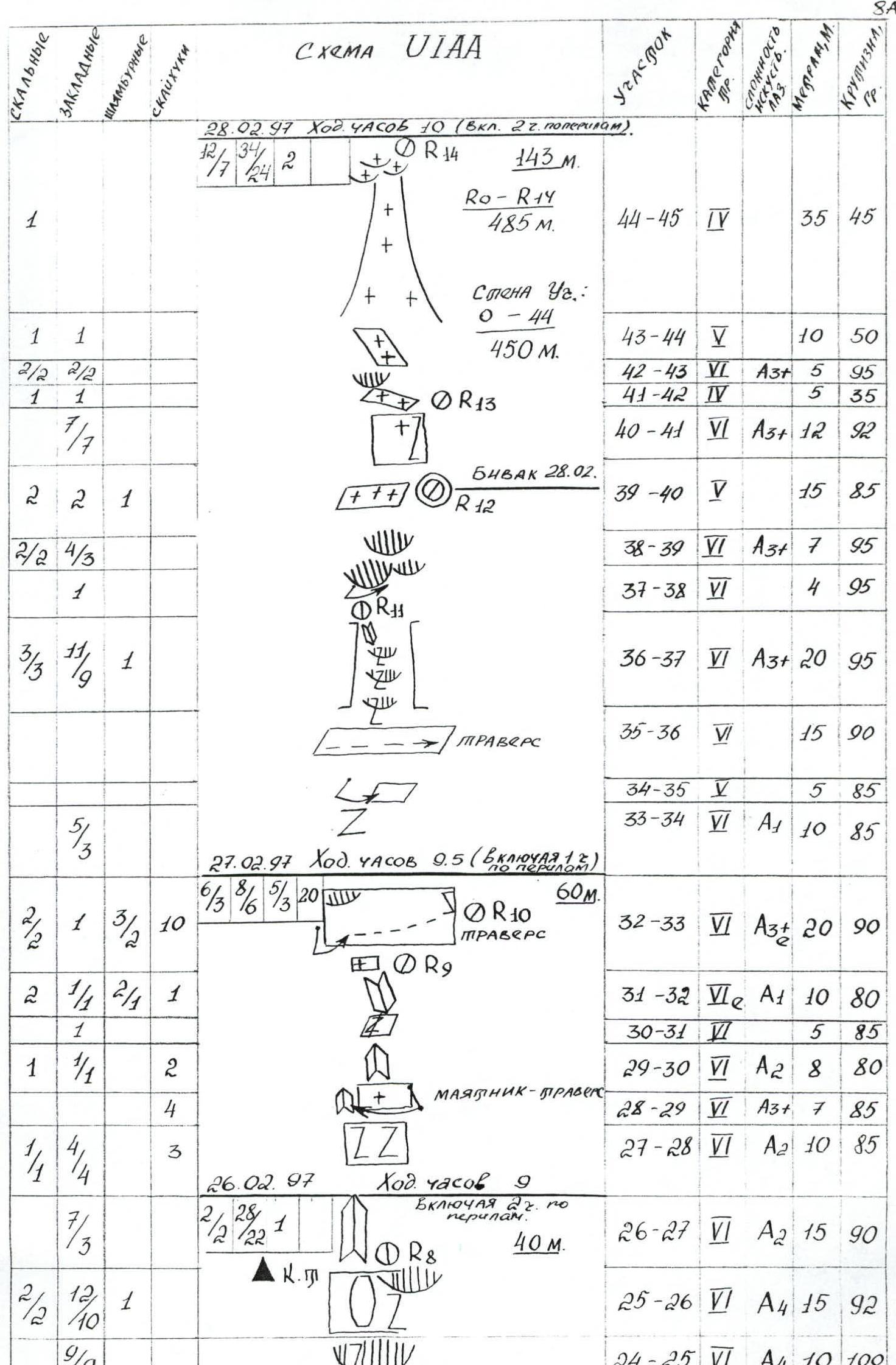
Description of the Route by Sections
R0–R1: The route starts with a steep snowy couloir leading to the base of the wall.
R1–R2: A snow-covered, gently sloping internal corner, climbing in crampons.
R2–R3: A ledge on snow-covered rocks.
R3–R4: A steep monolithic wall with a limited number of cracks and holds. I.T.O. Friends, pitons, nuts.
R4–R5: An inclined internal corner-couloir, empty snow on smooth, polished rocks. Belay via nuts. Climbing in crampons.
R5–R6: "Ram's foreheads" covered with empty snow. Careful climbing in crampons.
R6–R7: Traverse to the right towards the base of a snow-filled internal corner.
R7–R8: A steep internal corner. Tense free climbing. Belay - pitons, nuts.
R8–R9: "Ram's foreheads" covered with empty snow.
R9–R10: Traverse along a ledge to the right. Empty snow.
R10–R11: Steep "ram's foreheads" under the snow.
R11–R12: A steep snowy ledge. The snow's grip on the rock is very unreliable. 1st bivouac under the cornice on a snowdrift.
R12–R13: An internal corner with snow, passed by free climbing.
R13–R14: A snow-covered slab-ledge, climbing in crampons.
R14–R15: A complex wall with deep cracks. I.T.O. For passage, small stoppers and special ice axes were used. Belay is unreliable.
R15–R16: A snow-covered, iced-up chimney. I.T.O. on nuts and friends. At the end of the chimney - a cornice.
R16–R17: The cornice is passed on I.T.O. Deep cracks. Movement from left to right using skyhooks on the terrain. Belay through a piton.
R17–R18: An iced-up internal corner. Tense free climbing. Belay through nuts and pitons.
R18–R19: A destroyed, snow-covered internal corner, turning into a ribbed ledge. Free climbing.
R19–R20: A snowy ledge.
R20–R21: An internal corner with a deep, washed-out crack in the middle. Initially - free climbing. Further I.T.O., mainly on thin stoppers and skyhooks.
R21–R22: After a step - continuation of the internal corner. Climbing becomes more complex. I.T.O. Used micro nuts, barely driven pitons, skyhooks on the terrain.
R22–R23: A pendulum-traverse from under the overhang to the left. Climbing on skyhooks under a destroyed, live cornice. Belay through nuts. A stonefall hazard area.
R23–R24: To the right, a live, crumbling cornice. I.T.O. To the left of the cornice along a slab on bolt hangers and skyhooks.
R24–R25: A key point of the route. A multi-tiered, destroyed cornice is passed mainly using nut placements, as pitons could cause a block to break off.
R25–R26: An overhanging wall with a large live "patch". Very thin I.T.O., mainly on nut placements.
R26–R27: A steep internal corner. Partially passed by free climbing, partially by I.T.O. on nuts and friends.
R27–R28: Live fragments. I.T.O. on nut placements.
R28–R29: A pendulum-traverse to the left. Tense free climbing. In several places, I.T.O. on skyhooks along the terrain.
R29–R30: An internal corner-detachment. Very complex and tense free climbing, as well as I.T.O. on skyhooks and friends.
R30–R31: A detachment. Passed by free climbing. Belay - nuts.
R31–R32: A very destroyed internal corner. High probability of rockfall. Passed mainly by free climbing. Belay through a bolt hanger.
R32–R33: Traverse from under the cornice along a monolithic slab to the right. Another key point of the route. I.T.O. on micro-terrain using skyhooks. Belay - bolt hanger.
R33–R34: A crevice going to the right. I.T.O. on nuts and free climbing.
R34–R35: A pendulum on a narrow, rocky, iced-up ledge. Climbing in crampons.
R35–R36: Traverse along a ledge to the right towards the base of a characteristic "trough" in the upper part of the wall. Complex and very tense free climbing with minimal height gain.
R36–R37: Complex free climbing and I.T.O. through three tiers of cornices in the "trough". Used pitons, stoppers, friends. The "trough" is closed at the top by a cornice. Live rocks at the top.
R37–R38: A pendulum to the right part of the "trough" under the cornice.
R38–R39: A complex, overhanging section. Tense I.T.O. on pitons and nuts.
R39–R40: A narrow, iced-up ledge, widening at the end. Bivouac site #2.
R40–R41: An overhanging wall in a crevice to the right. Complex I.T.O. on friends and nuts.
R41–R42: A heavily snow-covered, inclined ledge.
R42–R43: An overhanging slab with a deep crack. Complex I.T.O. on nuts and pitons.
R43–R44: An inclined, snow-covered slab. Passed by free climbing. Belay - nuts, pitons.
R44–R45: A snowy-icy couloir. Turns into "ram's foreheads" of the roof. Free climbing.
R45–R46: Steepness decreases sharply. Free climbing on destroyed rocks and further on foot along frozen, snow-covered scree.
R46–R47: Initially gentle, then steeper snowy couloir leads over the edge of the roof.
R47–R48: A snowy slope leads to the base of one of the gendarmes on the pre-summit ridge. Bivouac #3 on the descent.
R48–R49: By passing the gendarme to the right via a couloir onto the ridge and further along rocks of medium difficulty - to the summit.
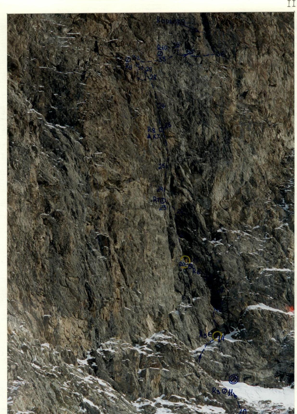
Photo 5. Main part of the route. February 25, 1997. Organization of a belay point on section 19–20.
Telectronic
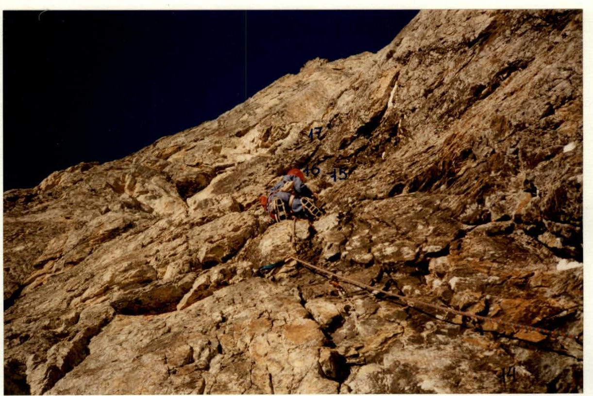
Photo 6. Movement on section 14–15. February 24, 1997.
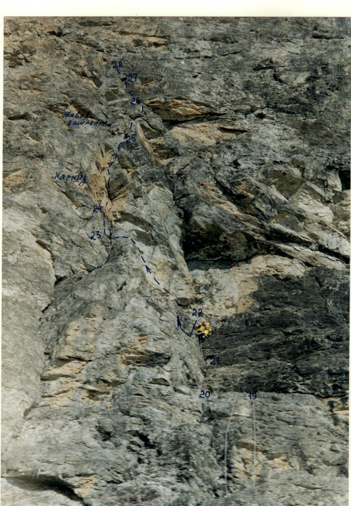
Photo 7. I.T.O. on section 21–22. February 25, 1997.
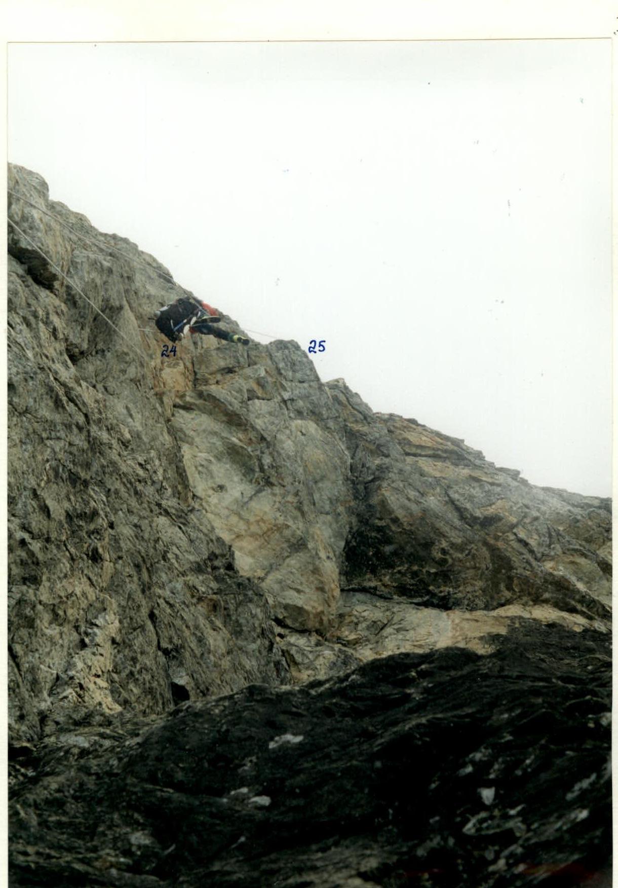
Photo 8. Movement along fixed ropes under the cornice. February 28, 1997. Section 24–25.
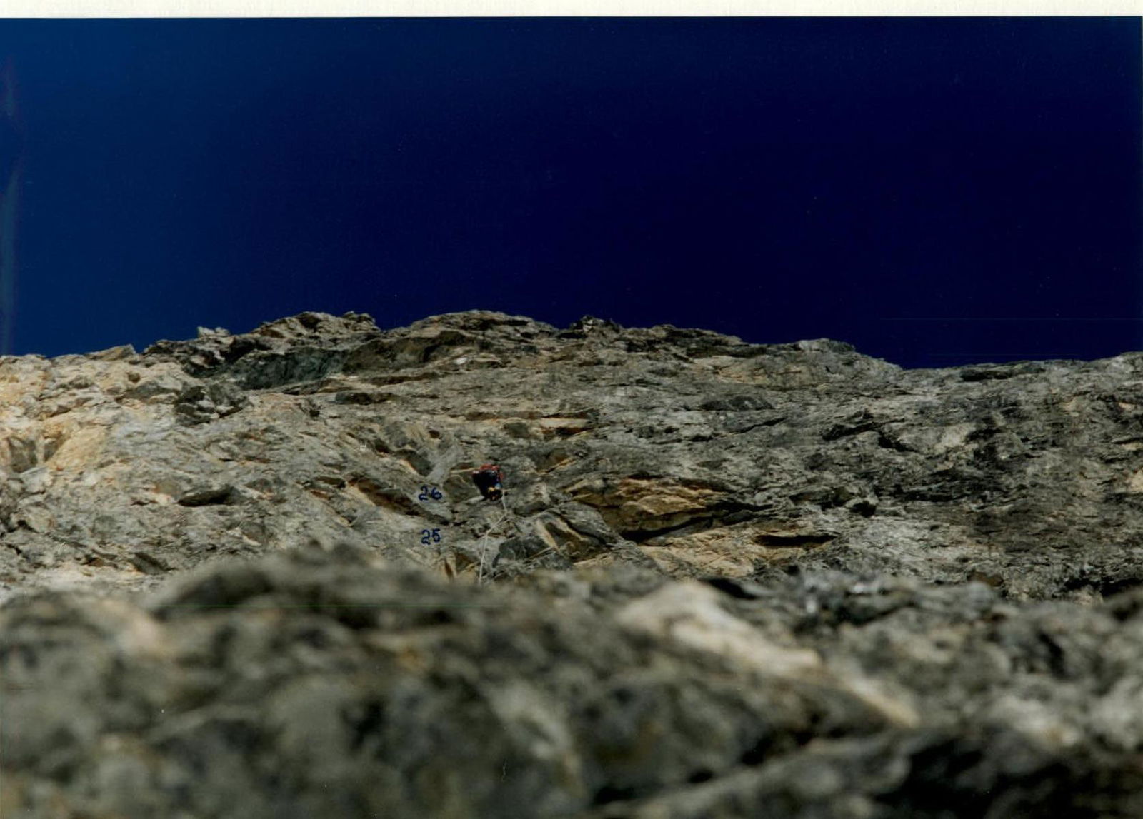
Photo 9. Passage of an overhanging slab with a live "patch". February 26, 1997. Section 25–26.
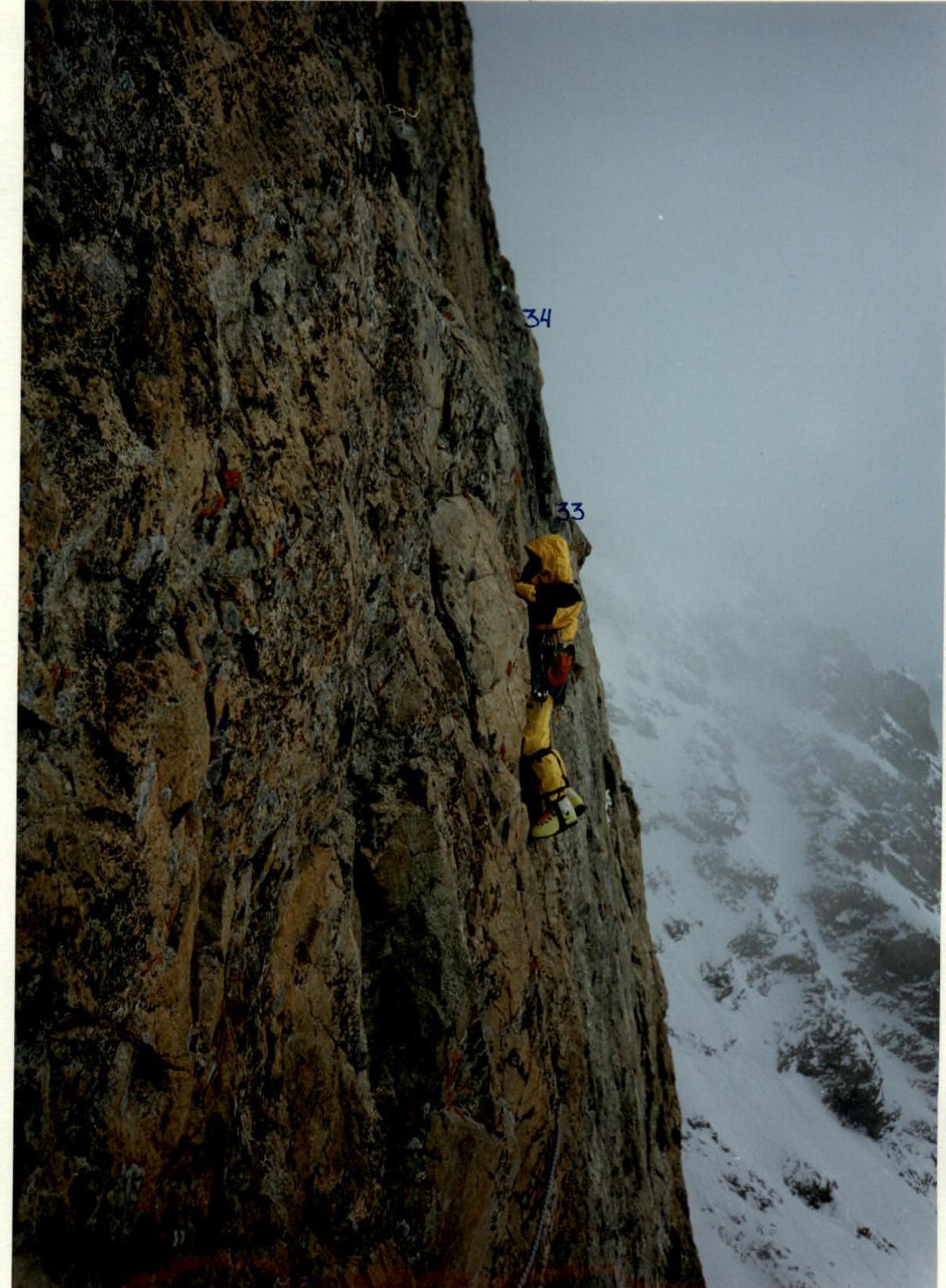
Photo 10. 20-meter traverse on skyhooks. February 27, 1997. Section 32–33.