256
Report
on the ascent to the summit of Shkhelda-Tau II Western, 4310 m via the center of the southern wall, made by the team of alpinist camp "Shkhelda" of the sports society "Spartak" consisting of:
| Name | Rank | Society | Role |
|---|---|---|---|
| Drobot S.Yu. | Candidate Master of Sports of the USSR | "Spartak" | team captain |
| Shamaev I.A. | Candidate Master of Sports of the USSR | —"— | |
| Odegov Yu.N. | 1st class | —"— | |
| Veziier A.E. | Candidate Master of Sports of the USSR | —"— | |
| Gritsenko V.N. | Candidate Master of Sports of the USSR | —"— |
Brief Geographical and Sporting Characteristics of the Ascent Object
The Shkhelda-Tau massif is located in the Main Caucasian Range to the southeast of Elbrus. The massif begins on the west with the peak Profsoyuzov and stretches almost five kilometers to the southeast to the Uzhbinsky Pass, forming a large arc convex to the north.
The massif features several peaks (from west to east):
- peak Profsoyuzov — 4110 m
- I Western Shkhelda — 4229 m
- II Western — 4310 m
- III Western — 4229 m
- Central — 4295 m
- Eastern — 4320 m
Most of the peaks are rocky.
The Shkhelda-Tau massif has long attracted the attention of mountaineers. Currently, more than 10 routes of category 5B complexity have been laid out to the peaks of the massif.
In 1969, a team from the Rostov regional council of the sports society "Lokomotiv" led by Yu. Artsishevsky ascended the left part of the southwest wall to the II Western peak of the Shkhelda-Tau massif, marking the beginning of the exploration of the southwest wall.
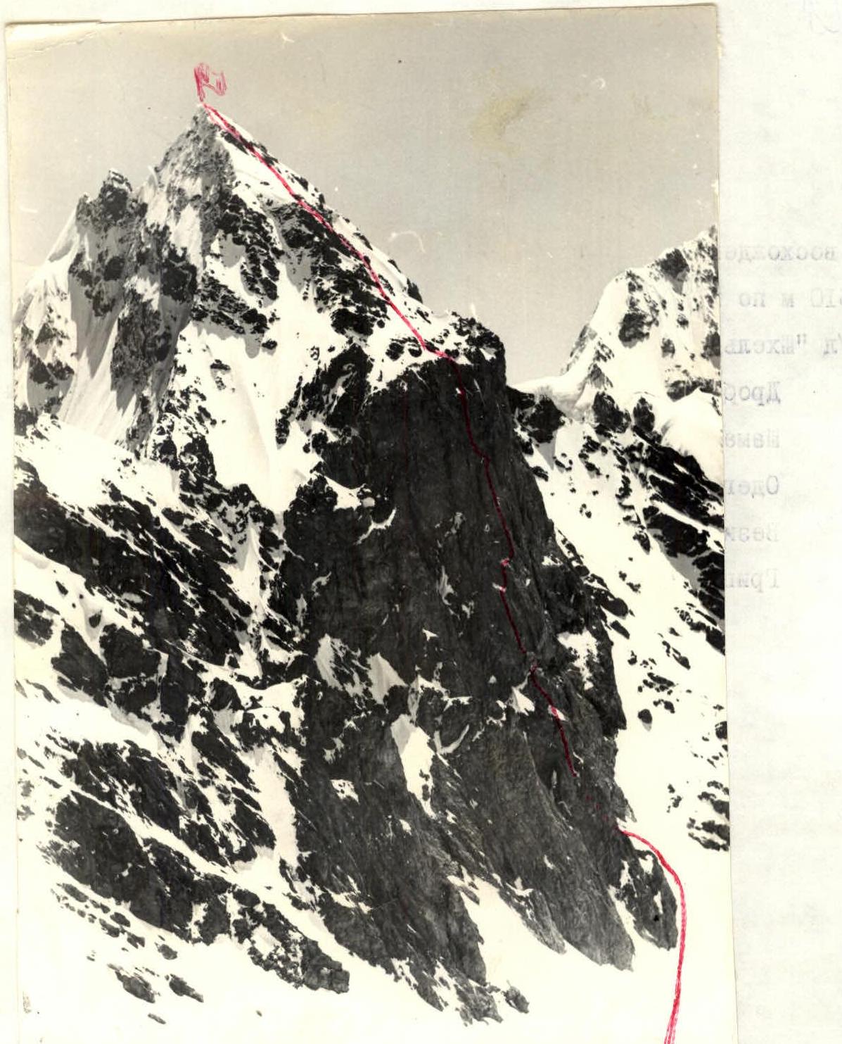
In 1974, a group from the Krasnodar regional council led by Akhtyrsky O.A. ascended the right part of this wall. After these ascents, the most interesting part of the wall remained — the center of the southern wall. Our team chose this route.
The approach to the southern walls of the massif takes 10–11 hours. From the Shkheldinsky valley, one can reach the South Shkheldinsky glacier via the Uzhbinsky Pass. From Svaneti, one can ascend via the Uzhba glacier and the South Shkheldinsky glacier (8–10 hours). The fastest way to get here is through:
- Sredny Pass
- peak Fizkulturnik
All approach paths present certain technical difficulties and require mountaineering preparation.
The weather conditions in the area of the South Shkheldinsky plateau have their own characteristics. The influence of warm air masses, which freely penetrate from the south, is felt here. Frequent:
- fogs
- precipitation in the form of snow
The Shkhelda-Tau massif is composed of granites, heavily destroyed on the southern slopes and more monolithic on the northern ones. The rocks are brittle and unstable. Shkhelda has long been known for its rockfalls. An exception is the southern wall of the Western peak. The wall has minimal fractures. The overall steepness is 70–85°. The upper part protects the wall from falling rocks. There are no balconies or large ledges. For bivouacs, a shelf near the small spall (point R1) and an inclined shelf at the base of the large spall (point R2) were identified. Both bivouacs were set up at point R2. The terrain includes slabs with few holds, overhanging sections, and narrow inclined ledges. On the "roof" and the pre-summit ridge, there is ice and firn snow.
The cracks require a diverse set of pitons. Shoulder pitons are necessary.
Team Preparation for the Ascent
The team's preparation for the ascent began at the end of the 1976 season. Working at the "Shkhelda" alpinist camp and venturing into the area of the southern wall of II Western Shkhelda-Tau, we repeatedly examined this beautiful wall. And, of course, the desire arose to climb it.
This decision was made in August 1976. During the summer at the "Shkhelda" alpinist camp, our team was finally formed for the ascent. After that, detailed preparation for the ascent began:
- Training ascents were conducted,
- Equipment was selected and packed,
- The experience of the team from the Krasnodar regional council of the sports society "Burevestnik," which ascended the right part of the southern wall in 1974, was studied.
For a more detailed study of the route, the wall was observed from the Kursants Pass, where a cache of food and equipment was made. Team members Drobot S.Yu. and Shamaev I.A., along with their groups of trainees, ascended II Western Shkhelda-Tau via a route of category 3B complexity. During these ascents:
- Observations of the wall were made from a close distance,
- The upper section of the route (the "roof") was examined,
- The descent route was studied.
After these ascents and observations, the ascent route, bivouac sites, equipment, and an approximate route description were finalized.
The tactical plan for the ascent was developed considering:
- The specifics of complex wall ascents in unstable weather conditions,
- Detailed study and analysis of the tactics used by the teams from the Rostov regional council of "Lokomotiv" and the Krasnodar regional council of "Burevestnik" on the left and right parts of the wall,
- Our team's experience.
The lead climber carried a lightened backpack with a small supply of pitons, kar bypasses, and personal rations. The second climber in the rope team had a backpack containing:
- ropes,
- a platform,
- a diverse set of pitons with karabiners,
- two-day rations for two,
- a down jacket.
The remaining load was evenly distributed among the team members.
On difficult sections, the lead climber ascended without a backpack, carrying only a set of pitons with karabiners, ladders, and a platform. The partner in the rope team provided insurance without being burdened by "hardware." The rest of the team climbed such sections via the fixed ropes and pulled up their backpacks.
It is worth noting that the team's good physical and technical preparation allowed them to implement their tactical plans.
The tactical plan included setting up three bivouacs: two on the wall and one on the "roof." On the first day of climbing, the group managed to reach the site of the second planned bivouac.
During the ascent, the lead rope team changed, maintaining a consistently high pace.
Communication on the route was maintained:
- by voice,
- using two "Vitalka" radios.
Thanks to thorough planning and execution, the organizational and tactical plan for the ascent was fully implemented.
The group's work schedule was as follows:
- July 10–11 — preparation for the departure to the South Shkheldinsky glacier. Group release.
- July 12 — group departure to Ak-Su bivouac.
- July 13 — transition from Ak-Su to Sredny Pass to Kursants Pass. Checking communication with the camp. Briefing the observation group. Observing the wall.
- July 14 — planned departure on the route, but due to bad weather, they had to wait on Kursants Pass.
- July 15 — departure on the route. Passage of sections R1, R2. Establishing a bivouac at point R2.
- July 16 — processing section R3.
- July 17 — processing the upper part of section R3, reaching the "roof."
- July 18 — ascent to the summit of Shkhelda-Tau II Western. Descent to the plateau—glacier. Bivouac—Ak-Su.
- Return to "Shkhelda" alpinist camp.
Order of Passage on the Route
July 12, 1977 — Departed from "Shkhelda" alpinist camp and bivouacked at Ak-Su.
July 13, 1977 — Passed through Sredny Pass and traversed to Kursants Pass to the base camp site. Set up a bivouac, sorted out the cache. Deployed the radio antenna and tested communication with the camp. Conducted wall observations throughout the day. Prepared for departure.
July 14, 1977 — A snowstorm began at night. Visibility was very poor in the morning, and snow had fallen. Departure was postponed. Communication with the camp was clear.
July 15, 1977 — Departed from Kursants Pass at 4:00. After half an hour, approached the wall. Re-examined the start of the route and planned the path. Began ascent. The initial part of the route was a steep, approximately 45–50°, firn slope about 200 m long. Immediately after the snow slope, intense work on the rocks began. From the angle formed by two counterforts, we moved onto the left counterfort and continued upwards. The rocks were difficult, and pitons, mainly channel and long ones, were used. The steepness was significant (70–75°), sometimes up to 85–90°. The rocks had small holds, glazed with seepage ice, and were dusted with snow after the bad weather, making movement difficult. "Live" rocks were present in this section. After 170–180 m of complex climbing, we reached a snowy shelf under the red rock. From here, we climbed 10 m up a snowy ridge and then ascended rocky terrain directly to a snowy shoulder under the overhanging wall at the base of the small spall. The rocks became steeper (85–90°) with small overhanging sections. The first climber had to ascend without a backpack. From the base of the spall, we moved left and upwards through an overhang, then directly up the gray wall, and right and upwards to a ledge near the spall. Along the ledge, we traversed 10 m to the right and then down a chimney to the left — exiting to the top of the spall. Here, the first control point was established. We passed this section fairly quickly. According to the plan, the first bivouac was to be on the spall, but it was only 11:30, and we continued.
While the group gathered, Gritsenko began processing the next section. It was not possible to go right due to rockfall and ice; going left was not feasible due to a negative wall — the only path was straight up. Initially, we climbed onto a slab, then right under a cornice, and under the cornice, we traversed left to cracks. From there, we ascended a vertical crack using a platform. The crack was shallow, and it was not always possible to place pitons. The entire section was overhanging and, despite not appearing too intimidating at first glance, required significant effort from Valentin to pass. He spent about 1 hour and 30 minutes on these 12 m, placing two shoulder pitons in the upper part, and finally reached a narrow ledge where he could stand with both feet. To facilitate passage on this section, a 10-meter ladder was hung, and we climbed up to the ledge. Then, we pulled up the backpacks.
From the rocky ledge, we moved right (5 m), then up and left (7 m), and directly up to a small internal angle. The entire section was very steep with overhanging parts (average steepness 90–95°), requiring intense effort. Again, we pulled up the backpacks. From the depression, we ascended right and upwards — difficult climbing. We approached a steep chimney filled with seepage ice and exited to an inclined shelf with seepage ice dusted with snow. The first climber went without a backpack; the rest followed via fixed ropes with jumar clamps.
The shelf was designated as the second bivouac site, but we reached it at 17:30, moving at a good pace. Three team members began setting up the bivouac, while the Gritsenko–Shamaev pair processed another 20-meter section. From the shelf, we traversed right along an inclined slab (5 m) and then ascended steep (75–80°) rocks with good holds. The final pitons were placed, and the team members joined at the bivouac site, where a platform was being prepared. By arranging ice blocks and securing them with snow, we created a decent semi-reclining bivouac. The tent was suspended as it could not be pitched. A ledge above protected us from falling rocks. We had a meal, drank tea, discussed the day's progress, and looked forward to the next day, as the most challenging part of the route — the large spall — lay ahead.
At 22:00, we extinguished the stove and gradually fell asleep.
July 16, 1977 — We rose at 4:00, and at 6:00, the Drobot–Shamaev rope team departed to process the route. We passed the fixed ropes left from the previous evening. Further climbing became challenging. A small 6-meter section with an overhang was initially climbed, then a ladder was hung, and we exited to a small ledge. Along the ledge, we traversed right to a small outcrop. We were at the base of the large spall, where the second control point was established. The passage of the spall was planned via two options:
- I — along the left edge, where a steep internal angle was visible from below.
- II — through the center of the spall.
From the bivouac, it became clear that option I was more complex due to the overhanging angle. Option II, although very challenging, started higher (by about 10–12 m) and was safer — so we decided to follow it.
From the shelf, complex climbing began immediately. Cracks were shallow, holds were smoothed, and a combination of difficult climbing and artificial aids on negative sections was required. The first 10 m took about an hour to pass. The direction was initially to the right, where a shoulder piton was placed on a slab for reliable insurance, then left and upwards towards a vaguely defined internal angle. To the right of this angle lay the most logical path. The main direction was towards the upper edge of the spall. This 70-meter section had a "belly" shape, with a steepness of 85–90° and individual 5–6 meter sections with overhangs. Very difficult climbing alternated with the use of artificial aids on negative sections. The spall ended on an inclined shelf, where a sitting bivouac was possible. Passing the spall took about six hours. On the shelf, we could finally stand. To the right of the spall, water flowed, and the wind blew spray towards us, gradually wetting us.
From the top of the spall, another very complex section began — the exit to the "roof." This 50-meter section was almost entirely negative (average steepness 90–95%). On the shelf, pitons were placed to secure the fixed rope. We climbed another 15 m from the shelf directly upwards, using artificial holds almost the entire time, and placed two shoulder pitons for reliable insurance. Then, we descended. The spray blown by the wind and water flowing along the ascent path soaked our clothing. Fog began to gather, and we had to stop processing — we wouldn't make it to the "roof" today. About 40–50 meters of very complex rock climbing remained.
We quickly descended to the bivouac, where the team served tea and inquired about the day's progress. After a challenging day, we rested, ate, and discussed plans for the next day.
We planned:
- An early departure by one rope team to process the upper section.
- The rest would gather the bivouac and ascend via the fixed ropes after the lead rope team reached the "roof."
After the evening radio check at 19:00, we went to sleep.
July 17, 1977 — A storm began at night: snow fell, and strong winds blew. The early departure planned for 5:00 was not possible. Only by 8:00 did "windows" appear, and the Gritsenko–Odegov rope team departed to process the route. At 10:00, they reached the upper shelf we had achieved the previous day, where pitons, a platform, and ladders were left. After the night's bad weather, everything was icy. All ropes resembled thick, icy cables, but at least the water had stopped flowing.
Valentin approached the platform and began processing the further route:
- Initially, he moved slightly left towards small ledges under a strongly overhanging part of the wall, which protected us from potential rockfall and water.
- Then, directly through a cornice, hammering in shoulder pitons, upwards.
The rocks here were heavily fissured and negatively inclined. It was cold, and the icy rocks complicated the route. Free climbing was almost impossible. After 2 hours and 30 minutes of work, the most difficult part was passed, and via radio, we decided it was time to dismantle the bivouac. There was enough time for the entire group to reach the "roof." We gathered our gear into three backpacks and began moving:
- To the shelf under the spall, we climbed via fixed ropes with backpacks.
- From the shelf, we ascended to the top of the spall using fixed ropes and jumar clamps.
While Shamaev and Veziier ascended to the top of the spall, Gritsenko passed the negative section and reached a wide, scree-covered ledge. We began pulling up the backpacks in two stages:
- Shamaev and Veziier pulled them to the spall and re-clipped them to the next rope.
- Odegov and Gritsenko pulled them to the "roof."
Using jumar clamps, we all reached the upper scree-covered ledge. From the ledge, another 6 m upwards through an overhang, and then right along an inclined ledge with "live" rocks — climbing of moderate difficulty — we reached the slopes of the "roof." At a rocky outcrop, we set up a platform. It was already 20:00. In the twilight, we pitched a tent, stretching it well. Here, we could lie down fully and avoid insurance. The wall was conquered. At 23:00, we fell asleep. The next day would be the summit day.
July 18, 1977 — We departed from the bivouac at 5:00:
- Initially, along rocks beside a snowy couloir.
- Then through the couloir and right along a snowy slope to the ridge.
- Along the ridge, we reached the summit.
At 7:00, we were on the summit. We found a note from a group from "Shkhelda" alpinist camp dated July 10, 1977 — a group of trainees led by Shamaev via a route of category 3B complexity. The weather was excellent.
At 8:30, we returned to the tent, gathered our bivouac gear, had breakfast, and, traversing the snowy slope along the rocks, followed the route of category 3B complexity.
At 12:00, we descended to the South Shkheldinsky glacier plateau, where we met our observers. From the plateau, via the Biwakny Pass, we transitioned to the Ak-Su glacier and then to Ak-Su bivouac.
At 18:30, the entire group, along with the observers, arrived back at the camp.
Overall Assessment of the Team's Actions
The team was assembled from instructors at "Shkhelda" alpinist camp. The Drobot–Shamaev pair had come a long way from novice to Candidate Master of Sports and had completed many ascents of categories 4–5 and 6B complexity together by the time of this ascent. The Gritsenko–Veziier pair also had many joint ascents, both in the Caucasus and in the Pamir. Odegov, who joined the team as the fifth member, had by this time conducted joint training ascents and fit well into the collective. Moreover, long-standing friendly relations helped us all to quickly and collectively make decisions in any difficult situations on the route.
The previously accumulated experience helped the team:
- to navigate the route correctly,
- to develop tactical ascent plans,
- to overcome technical difficulties on the route.
The atmosphere on the route was businesslike and calm. The actions of all participants were characterized by precision, great work capacity, and technical skill. Everyone worked as the lead climber at some point.
Physically, all team members were in excellent shape and felt good during the ascent.
These factors allowed the team to complete the route clearly and quickly.
Team Captain, Candidate Master of Sports of the USSR — S.Yu. Drobot. Team Coach, Master of Sports of the USSR — Yu.P. Shulgin.
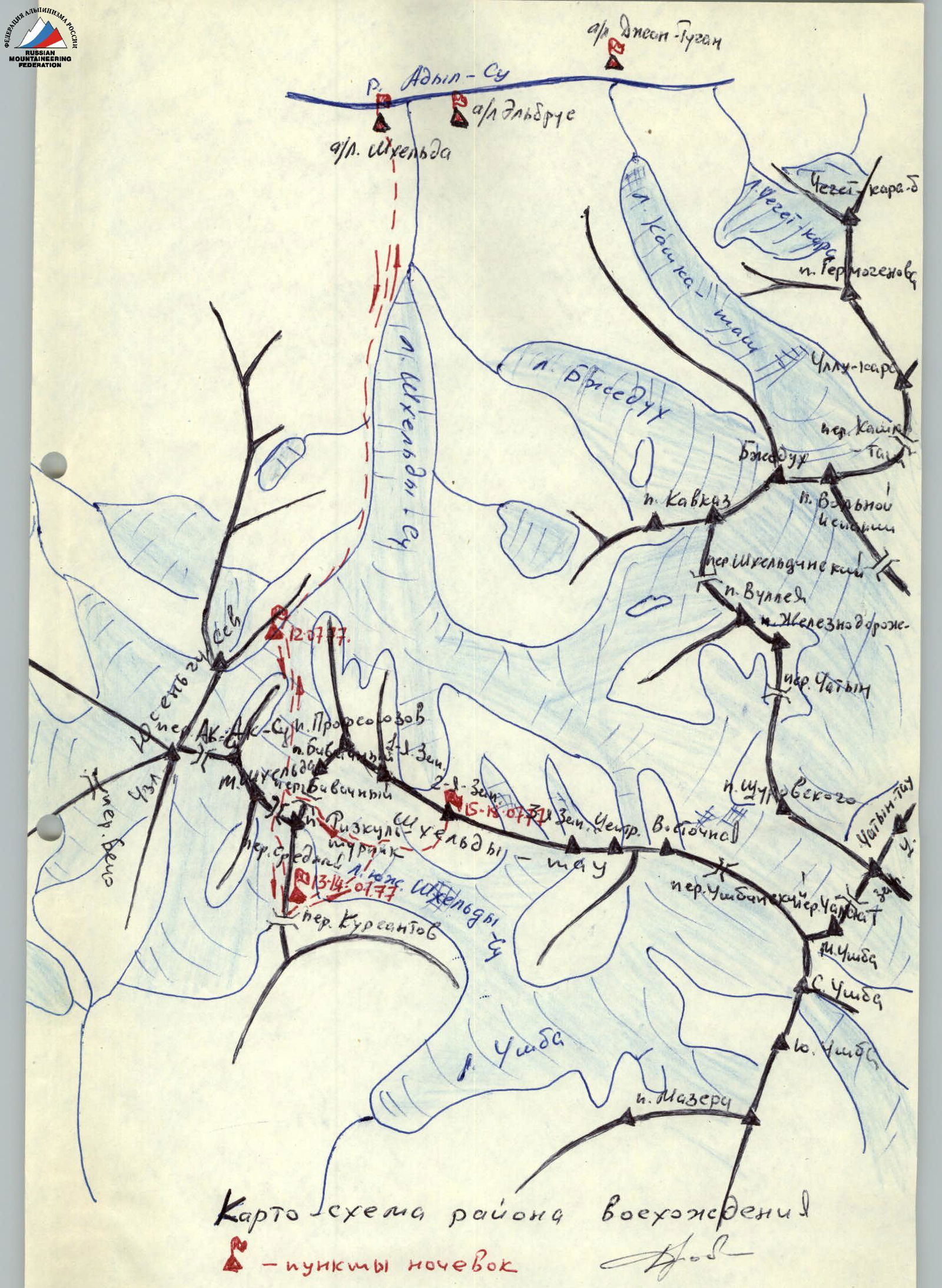
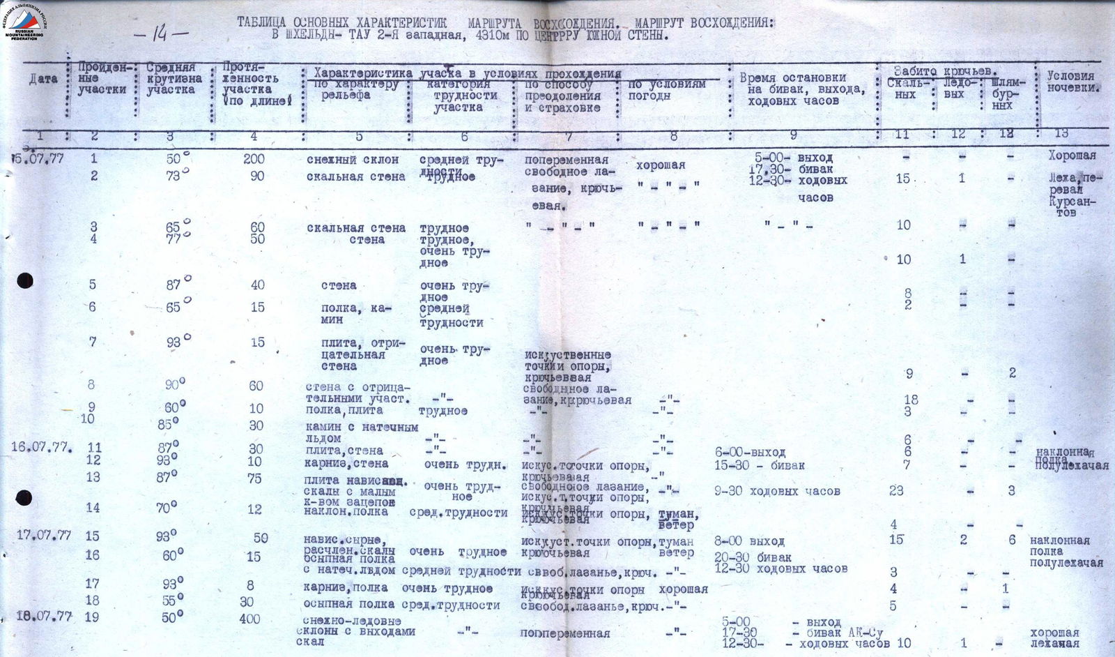
Table of Main Characteristics of the Ascent Route
Ascent Route: Shkhelda-Tau II Western, 4310 m via the center of the southern wall.
| Date | Sections Passed | Average Steepness of Section | Section Length, m | Terrain Characteristics | Difficulty Category | Method of Ascent and Insurance | Weather Conditions | Time of Bivouac, Departure, Climbing Hours | Pitons Driven, Rock | Pitons Driven, Ice | Pitons Driven, Shoulder | Bivouac Conditions |
|---|---|---|---|---|---|---|---|---|---|---|---|---|
| 15.07.77 | R1 | 50° | 200 | Snow slope | Medium difficulty | Alternating, free climbing, piton | Good | 5:00 — departure | 15 | 1 | Good | |
| R2 | 73° | 90 | Rocky wall | Difficult | Free climbing | 17:30 — bivouac | 10 | Lying, Kursants Pass | ||||
| R3 | 65° | 60 | Rocky wall | Difficult | 12:30 — climbing hours | |||||||
| R4 | 77° | 50 | Wall | Difficult | ||||||||
| R5 | 87° | 40 | Wall | Very difficult | 10 | 1 | ||||||
| R6 | 65° | 15 | Ledge, chimney | Medium difficulty | 8 | 2 | ||||||
| R7 | 93° | 15 | Slab, negative wall | Very difficult | Artificial holds, piton | 9 | 2 | |||||
| R8 | 90° | 60 | Wall with negative sections | Very difficult | Free climbing, piton | 18 | 3 | |||||
| R9 | 60° | 10 | Ledge, slab | Difficult | ||||||||
| R10 | 85° | 30 | Chimney with seepage ice | |||||||||
| 16.07.77 | R11 | 87° | 30 | Slab, wall | Very difficult | 6:00 — departure | 6 | |||||
| R12 | 93° | 10 | Cornice, wall | Very difficult | Artificial holds, piton | 15:30 — bivouac | 6 | 1 | Inclined semi-reclining | |||
| R13 | 87° | 75 | Overhanging slab, rocks with few holds | Very difficult | Free climbing, artificial holds, piton | 9:30 — climbing hours | 23 | 3 | ||||
| R14 | 70° | 12 | Slope, ledge | Medium difficulty | Artificial holds, fog, wind, piton | 4 | ||||||
| 17.07.77 | R15 | 93° | 50 | Overhanging, fragmented rocks | Very difficult | Artificial holds, fog, wind, piton | 8:00 — departure | 15 | 2 | 6 | Inclined semi-reclining | |
| R16 | 60° | 15 | Scree ledge with seepage ice | Medium difficulty | Free climbing, piton | 20:30 — bivouac | ||||||
| R17 | 93° | 8 | Cornice, ledge | Very difficult | Artificial holds, good | 12:30 — climbing hours | 3 | |||||
| R18 | 55° | 30 | Scree ledge | Medium difficulty | Free climbing, piton | 4 | 1 | |||||
| 18.07.77 | R19 | 50° | 400 | Snowy-icy slopes with rock outcrops | Alternating | Good | 5:00 — departure | Good reclining | ||||
| 17:30 — Ak-Su bivouac | ||||||||||||
| 12:30 — climbing hours | 10 | 1 |
Section R2 (6–7). Passing the "sturena" above alZO.
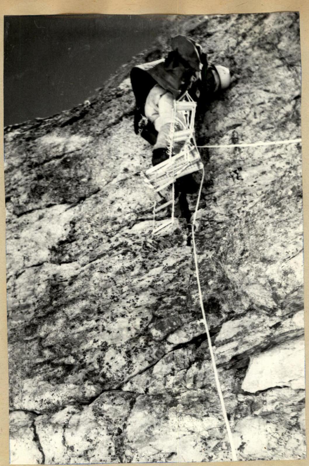
Section R3 (12–15). Pulling up backpacks on the large spall. The lead pair is visible at the top, having already reached the "roof." (15)

Section R3 (14–15). Processing the upper part. Exiting to the "roof."