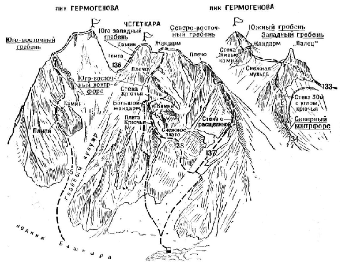
Chegetkara via the South-Eastern counterfort (B. Garf's itinerary, category IV).
The path from the Djantugan alpine camp (a group of 4-5 people) to the initial bivouac on the talus slopes above the rocky step on the right bank of the Bashkara glacier under the South-Eastern slopes of Chegetkara peak is described in routes 135 and 137. From the bivouac, turn right and ascend via the talus on the right side of the wide couloir up the southern slope of the North-Eastern ridge of Chegetkara peak to a platform under the rocks of the cave. From the platform, cross the couloir to the left and move via simple but steep rocks with snowy sections ("live" rocks, belay!) upwards to the left onto a snow-firn plateau. From here, sharply turn left, cross the plateau and exit onto the rocks of a small edge of the Big gendarme of the South-Eastern counterfort of Chegetkara peak. Ascend via simple rocks of the edge straight up to the Big light-yellow gendarme. Bypass the gendarme via the slabs, then via a ledge on the right side to the exit to a steep ice-snow couloir. Ascend via smooth, steep, and partially snow-covered slabs (key section of the route, "live" rocks, piton belay, rocks falling down the couloir!) on the left side of the couloir for 150-180 m to a col. Variant of ascent to the col by A. Fomin and V. Kovtun: from the initial bivouac, ascend via a talus slope, then via the first narrow snowy couloir to the right of the South-Eastern counterfort to its expansion. Here, exit left onto the rocks of the South-Eastern counterfort and via ledges on the right side of the counterfort, make an 80-meter ascent to a horizontal talus ledge. From the left end of the ledge, ascend 80-100 m upwards via simple and medium-difficulty rocks with an exit via a ledge to the right into a rocky couloir. Ascend via the couloir, with a ledge in its upper part, for 140 m under the wall of the Big gendarme. Ascend via difficult smooth rocks with few holds on the wall on the right side to the Big gendarme and descend from it to the col. Exit via a sharp ice-snow col under the second ascent of the counterfort. There is a platform on the right below the col under the wall of the ascent. From the initial bivouac, 6-7 hours. On the platform, there is a control point. From the platform, ascend via medium-difficulty rocks upwards to the right onto a small ridge and via it to the left onto the South-Eastern counterfort. Further, exit via a simple rocky-snowy ridge under a gendarme of the North-Eastern ridge. Bypass the gendarme via ledges and simple rocks on the left, exit into a snowy hollow and via it under the rocky wall of the summit tower. Ascend via medium-difficulty rocks of the 80-meter wall with good holds, then via its right side to the summit of Chegetkara. From the platform with the control point, 5-6 hours. Bivouac in the hollow. Descend via the North-Eastern or South-Western ridges (see routes 136, 137). Duration of the route is 3 days. Special equipment for 4 people: main rope - 2 × 30 m, expendable cordelette - 2 m, rock pitons - 10-12, ice pitons - 1, rock hammers - 2, carabiners - 10-12, tent - 1. Possible bivouac locations - on a small snowy plateau, platform, snowy ridge, and summit. ("Baksan Valley", A.F. Naumov)


Comments
Sign in to leave a comment