
Passport
- Class — technical.
- Central Caucasus. 2.4
- Chatyn Glavny (4368 m), via the diamond-shaped section of the North Face.
- Difficulty category: 6A.
- Height difference of the wall section of the route — 770 m.
Length — 1200 m. Average slope of the main part of the route — 80°. Length of sections with 5–6 difficulty category — 580 m.
-
Pitons left on the route:
- rock pitons — 14
- bolt pitons — 45
-
Climbing hours — 64 days — 8
-
Overnights: in a cave — 1 on a platform — 7
-
Team leader — Nilov Sergey Alekseyevich.
Team members:
- Korol Yevgeny Mikhaylovich
- Doronin Sergey Valentinovich (up to 4040 m on the main part of the route)
-
Coach — Volodin Viktor Gennadyevich.
-
Approach to the route — January 17, 2007. Summit — January 25, 2007. Return to camp — January 27, 2007.
-
Organizing bodies: CSKA named after Demchenko, Moscow, Vizbor Club, Moscow, Russian State University of Physical Education (RGUFK)
General photo of the summit
Chatyn – 4368 m.

Team's route Site of overnight stay
Route sheet indicating the path taken
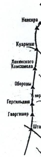
Fig. 32. Diagram of the Chalaat glacier up to the Nenskra ridge
Glaciers:
- I — Chalaat;
- II — Upper plateau;
- III — Western branch;
- IV — Southwestern branch of the Chalaat glacier;
- V — Ushba plateau;
- VI — South Shkhelda;
- VII — Upper plateau of the South Shkhelda glacier;
- VIII — Southeastern Kvami;
- IX — Kvam;
- X — Kerunda;
- XI — Khevay;
- XII — Kvish;
- XIII — Tsalgmyl;
- XIV — Bak;
- XV — Charynda;
- XVI — Nakra;
- XVII — Ledesh;
- XVIII — Leyrag;
- XIX — North Tsalgmyl;
- XX — South Tsalgmyl.
Initial base points:
- 1 — Upper plateau of the Chalaat glacier;
- 2 — Upper plateau of the Western branch of the Chalaat glacier;
- 3 — Guli moraine;
- 4 — Shoulder of the Northwest counterfort of North Ushba;
- 5 — Medial moraine of the Ushba glacier;
- 6 — Hunting grounds;
- 7 — Upper plateau of the South Shkhelda glacier;
- 8 — Dolra moraine;
- 9 — Khevay;
- 10 — Kvish;
- 11 — Nakra camps;
- 12 — Ledesh moraine.
Brief overview of the area and the ascent object
The Chatyn massif is located in a small node of the Main Caucasian Range (MCR), surrounding the high-altitude Ushba plateau. In the northwest corner, the snow-ice slope of Peak Shurovsky gently rises from the plateau. East of the peak, within a short northeast ridge from the plateau, lies the Chatyn massif itself, south of which, on the eastern side of the plateau, stands the rocky peak of Ushba Mala. From the southern corner of the plateau, its main massif, Ushba, rises. From the southwest side of the plateau, the heavily dissected Shkhelda massif extends westward.
The Chatyn massif (4368 m) with its glaciated Western summit (4310 m) intrudes into the Chalaat glacier via a short spur. After the Eastern, less pronounced summit, the spur turns south and drops down over the western branch of the Chalaat glacier. The southern ridges, edges, and walls are weakly explored by climbers.
The central part of the North Face is an enormous black diamond-shaped, 800-meter tall vertical rock face above the upper plateau of the Chalaat glacier.
Our chosen route, L. Myshlyaev's route (via the chimneys of the North Face through the Diamond), begins with the Lower chimney (Myshlyaev's chimney) from the steep snow-ice slope on the right side of the rocky spur of the North Face and continues almost vertically up through chimneys and inner corners that "cut through" the entire right side of the central part of the Diamond on the North Face. A good landmark is the large, gently sloping, snow-covered ledge (Abalakovskaya) that goes left and upwards from where it intersects with the inner corner followed by the route.
After completing the main part of the route (the Diamond at 4040 m), the ascent to the "roof" and the movement to the Main summit of the massif do not present significant technical difficulties. Good landmarks include:
- a ridge
- a couloir
- the summit ridge
The descent was made via the ascent route.
Approach to the route
From the Shkhelda alpine base, ascend along the trail on the right slope of the Shkhelda valley, initially through dense forest and then along grassy slopes, to the Shkhelda glacier. 300 m above the glacier's tongue, exit onto the lateral moraine. Follow the left (orographically) moraine about 500 m upstream. Then, exit the glacier to the left and ascend along a trail on the slope of a "pocket" between two ridges, alongside the glacier, towards the confluence of the Aksu glacier into the Shkhelda glacier.
Here, turn left and follow the left side of the medial moraine of the glacier to reach the "Shkhelda camps" — platforms on the left of the glacier on a rocky outcrop at the foot of the Western ridge of Peak Vulleya. From the Shkhelda alpine base, it takes 7 hours.
From the "Shkhelda camps," cross the left branch of the Shkhelda glacier upwards to the right and exit under the right side of the Chatyn pass. From the glacier, ascend a steep snowy slope upwards and to the left, then continue onto the rocks. Ascend through snowy and icy rocks of medium difficulty, then via simple ascents to the right side of the ridge saddle — the South (False) Chatyn pass. From the "Shkhelda camps," it takes 3 hours.
From the pass, descend to the right along snowy and icy slopes, bypassing crevasses to the right, closer to the slopes of Peak Shurovsky, and descend onto the upper plateau of the Chalaat glacier. Cross its gently sloping part. Under the North Face of Chatyn's Diamond, not reaching the bergschrund, lies the initial bivouac site (snow caves). From the pass, it takes 1.5 hours.
Technical photograph of the route
Chatyn 4368 m.
 Team's route
Control tours
Site of overnight stay
Team's route
Control tours
Site of overnight stay
Route diagram in UIAA symbols
| Section # | X Y Z | UIAA Diagram | L, m | Slope, ° | Cat. | ||
|---|---|---|---|---|---|---|---|
| Rock | I | B | |||||
| R13 | (6+2*) | - | (2+1*)/1 | 45 | 95 | VI+ A2 | |
| R12 | (8+1*)/5 | - | (1+1*) | 35 | 95 | VI+ A2 | |
| R11 | 5/3 | - | (2+2*) | KT3 | 10 | 95 | VI+ A2 |
| R10 | 6/2 | 5/3 | - | 40 | 60 | V- A1 | |
| R9 | (6+1*)/3 | 5/1 | (2+2*) | 25 | 85 | V+ A1 | |
| R8 | (8+1*)/5 | - | (10+10*)/1 | 30 | 92 | VI+ A2 | |
| R7 | 5/2 | 4 | (3+3*)/1 | 20 | 83 | VI A1 | |
| R6 | (7+1*)/3 | 1/1 | (5+3*)/3 | KT2 | 30 | 75 | V+ A1 |
| R5 | (6+2*)/2 | 4/1 | (5+5*)/2 | 50 | 85 | VI A2 | |
| R4 | (9+2*)/1 | 3 | (3+3*)/1 | 45 | 80 | VI A2 | |
| R3 | (18+1*)/3 | 3/1 | (4+2*)/2 | 45 | 90 | VI+ A2 | |
| R2 | (8+1*)/4 | 1/1 | (3+3*)/1 | 25 | 70 | VI A2 | |
| R1 | (11+2*)/7 | 3/1 | (5+5*)/2 | 35 | 95 | VI A2 | |
| R0 | 4 ice | - | - | 60 | 60 | IV |
M 1:2000
Route diagram in UIAA symbols
| Section # | Pitons | UIAA Diagram | L, m | Slope, ° | Cat. | ||
|---|---|---|---|---|---|---|---|
| Rock | I | B | |||||
| R18 | 2 ice | - | - | 60 | 40 | III+ | |
| R17 | 7 ice | - | - | 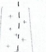 | 180 | 50 | IV |
| R16 | 4 ice | - | - | 25 | 60 | V+ | |
| R15 | 8 ice | - | - | 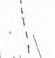 | 200 | 45 | IV- |
| R14 | 2 | - | - | 20 | 55 | V- |
Route description by sections
R0–R1: Approach to the wall via an ice slope at 40–45°, 35 m, with a bergschrund in the lower part. The upper edge of the bergschrund is 1.5–2 m high, covered by a snow bridge.
R1–R2: Directly upwards through a very complex narrow chimney with an overhang in the middle part (35 m, 95°) to an inclined slab on the left. The station is on the slab and is uncomfortable.
R2–R3: Up the vertical slab, exit right into an inclined inner corner. Up the right side of the corner (25 m, 70°) to a comfortable ledge at its base.
R3–R4: From the comfortable ledge straight up, initially through the center of the inner corner, then across slabs under the overhang. The cornice is bypassed on the left via a very complex wall, leading to the start of the overhanging inner corner. The station is in stirrups. (45 m, 90°)
R4–R5: Up the left wall of the large inner corner under a half-meter cornice. From under the cornice, right into an inclined chimney. Up the chimney, left and upwards through difficult, icy rocks to a small platform. (45 m, 80°)
R5–R6: Upwards, bypassing overhanging rocks on the right via slabs and icy ledges, exit onto a large, snow-covered, inclined diagonal ledge (Abalakovskaya ledge) (50 m, 85°). The ledge hosts a bivouac.
R6–R7: From the ledge, traverse right to the start of the inner corner. Control tour #1. Up the corner straight, to an inclined slab on a large outcrop. (30 m, 75°)
R7–R8: Right and upwards through two large blocks to the base of the left wall of a wide, vertical inner corner. Up the monolithic, overhanging, very complex wall straight, to a diagonal, comfortable, wide ledge. Control tour #2 (30 m, 95°)
R8–R9: From control tour #3, 3 m along the ledge to the left, bypassing overhanging rocks, exit into an inner corner. Up the corner, right and upwards. Station on icy slabs resembling "ram's foreheads." (28 m, 85°)
R9–R10: Upwards, left through destroyed, icy, and snowy ledges and slabs onto a small platform under an overhang. Control tour #3. (40 m, 60°)
R10–R11: Straight up through a narrow crack through the overhang. From the end of the crack, a pendulum swing right into the base of an overhanging, not wide chimney. (10 m, 95°). Station in stirrups.
R11–R12: Up the narrow, winding, overhanging chimney, initially up, then where it widens, left under a cornice. From under the cornice, right through a narrow slit in the chimney to the next widening. On the right wall of the chimney, a station in stirrups. (35 m, 95°)
R12–R13: From the station, left across a monolithic wall, enter the next narrowing of the chimney. Up the center of the chimney to a narrow, horizontal ledge cutting across the chimney. Control tour #4. (45 m, 95°)
R13–R14: Upwards, left through a gently sloping, widening chimney to a vertical wall. Up the wall, right and upwards. On snowy slabs, a station. (25 m, 55°)
R14–R15: Through a series of slabs on a firn slope, upwards and left to the base of a wall. (200 m, 45°)
R15–R16: Up the wall of medium and above medium difficulty straight, to an inclined ledge on the edge of a small couloir. (25 m, 60°)
R16–R17: Up the snowy couloir, slightly right, through a snowy cornice onto a simple, rocky, snowy ridge. (180 m, 50°)
R17–R18: Along the simple rocky ridge with snowy cornices, exit onto the summit. (60 m, 40°)
Route profile
 M 1:4000
Ascent schedule
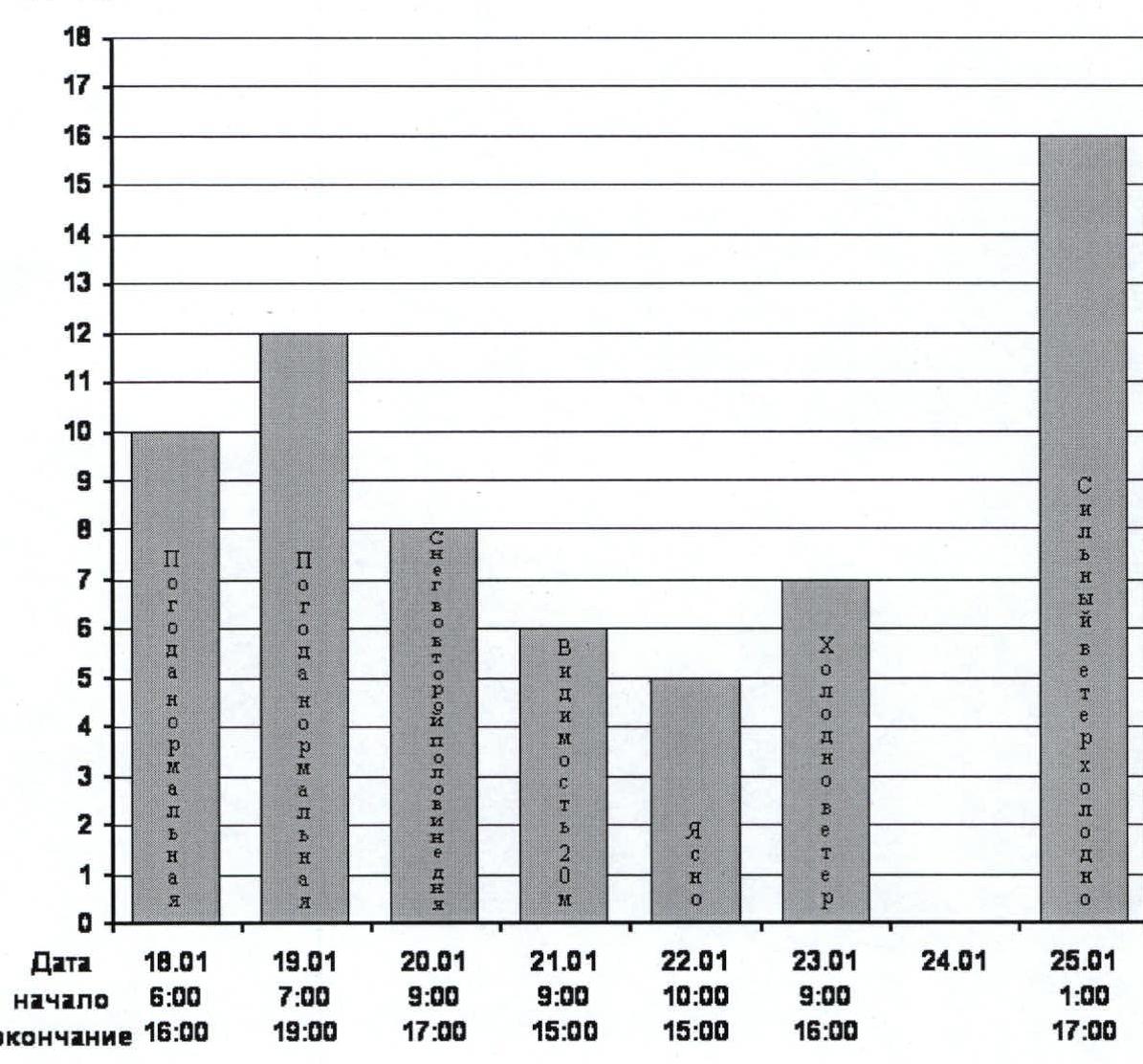
| Date | 18.01 | 19.01 | 20.01 | 21.01 | 22.01 | 23.01 | 24.01 | 25.01 |
|---|---|---|---|---|---|---|---|---|
| start | 6:00 | 7:00 | 9:00 | 9:00 | 10:00 | 9:00 | 1:00 | |
| end | 16:00 | 19:00 | 17:00 | 15:00 | 15:00 | 16:00 | 17:00 |
Team's tactical actions
Preparation for the ascent began in the spring of 2006. In Crimea, on the south wall of the "Castle," techniques were practiced: movement on IT with new equipment and gear, the order of movement for links and individual participants within them, interaction of the entire team on belays, organization of suspended bivouacs, and transportation of cargo. All practiced technical techniques were successfully applied during the passage of complex routes in the summer on the Caucasus (Cey valley). In the autumn, hanging platforms, kitchens, and transport bags were manufactured and selected with winter conditions in mind. Since the use of observers and auxiliary groups is currently impossible for this route, we paid special attention to the selection of reliable radio communication means, food supplies, fuel, personal clothing, and participant equipment. The fight was for every gram. The condition was that safety should not be compromised, as in case of unforeseen situations, we could not count on "outside" help. The conclusion was that a clear, well-thought-out tactical plan, taking everything into account, and its strict execution were necessary. The passage was broken down into the following stages:
- An auxiliary group of 4 people, including one participant (the leader) of the ascent (Nilov), carried all the cargo under the wall. They prepared the initial bivouac (snow cave). They determined the state of the route, assessed objective dangers considering possible adverse weather conditions, and spent the necessary time under the wall to gather information and preliminary analysis.
- The return of the auxiliary group. Full analysis of the situation. Determining the time of the main group's exit, considering the long-term weather forecast and any additional information that might have become available. The main group's exit.
- Approach and work on the main (wall) part of the route. The group consisted of 3 people: a working pair (Nilov, Korol) and an assistant (Doronin). There were two key sections on the route: the lower and upper chimneys, as well as a complex 30-meter wall 1.5 ropes above the "Abalakovskaya ledge." The location of the "keys" and the developed relief allowed for the application of a movement schedule and arrangement of hanging overnight stays: passing 2 full ropes per day, carrying a minimally necessary supply for 7 days. This allowed not only to hang the planned sections but also, if necessary, to reliably lower an injured or helpless participant from any point of movement on the planned sections to the overnight stay site without additional rope hanging. There are two overnight stays: the first at the base of the inner corner at the exit from the lower chimney, and the second on the "Abalakovskaya ledge." The arrangement of bivouacs, although the first one was inconvenient and somewhat low, allowed the assistant to work with a full load (equipment setup and dismantle) on days when the upper working pair passed relatively "easy sections," and vice versa, on days of "key ropes," the assistant, occupied with light bivouac work, could come to the aid of the upper pair or replace one of them if necessary, without losing pace or altering the ascent schedule. We successfully implemented this when, despite a favorable forecast, the weather deteriorated sharply. Precipitation (snow), increased wind, and a drop in temperature on January 19–21 led to a reduction in working hours and replacements during the passage of the upper chimney. However, there was no falling behind the schedule.
- A full day of rest. Exit to the summit and return of the pair Nilov–Korol (the planned, fastest, most mobile, and safest option according to our calculations). Descent via the ascent route.
- Return to the Elbrus Training Center.
We managed to fully meet the coach's instructions. There were no deviations from the tactical plan, and this is practically impossible when every detail is considered and everything is thought out "two steps ahead."
The participants' well-being is excellent. Before the ascent, we spent about 2 weeks at the Elbrus Training Center. As an acclimatization exit, we ascended:
- Peak 1 May
- Peak Aviatsii
Korol participated in an attempt to ascend "Shkhelda." Doronin went to "Elbrus."
Due to a broken camera, there are no photographs from the summit.
Equipment list
- Rope — 5 × 50 m, of which:
- 2 — dynamic B.D.
- 3 — static Lanex.
- Quickdraws with carabiners — 30 pcs.
- Extenders — 14 pcs.
- Hammer — 2 pcs.
- Ice tool — 2 pcs.
- Extractor — 1 pc.
- Hook ladders — 2 pcs.
- Crampons — 1 set.
- Rock pitons — 40 pcs.
- Ice screws — 8 pcs.
- Bolt kit (handle-drill, adapter, 2 S.D.S. drills).
- Stopper set — 11 pcs.
- Camalots — 10 pcs.
- Crampons — 3 pairs.
- Jumar — 5 pcs.
- Kroll — 1 pc.
- Figure eights — 3 pcs.
- Helmets — 3 pcs.
- Harness + self-belay — 3 pcs.
- Platform — 1 pc.
- Sleeping bags — 3 pcs.
- Wind and waterproof clothing set — 3 pcs.
- Gas burners — 2 pcs.
- Gas cylinders — 10 × 0.5 l.
- Kitchen set — 1 set.
- Lighters — 4 pcs.
- Headlamps — 3 pcs.
- First aid kit — 1 set.
- Radio station — 1 pc.
- Telescopic poles — 6 pcs.
- Sunglasses — 3 pcs.
- Karimat — 3 pcs.
- High-calorie and quick-preparation food set.
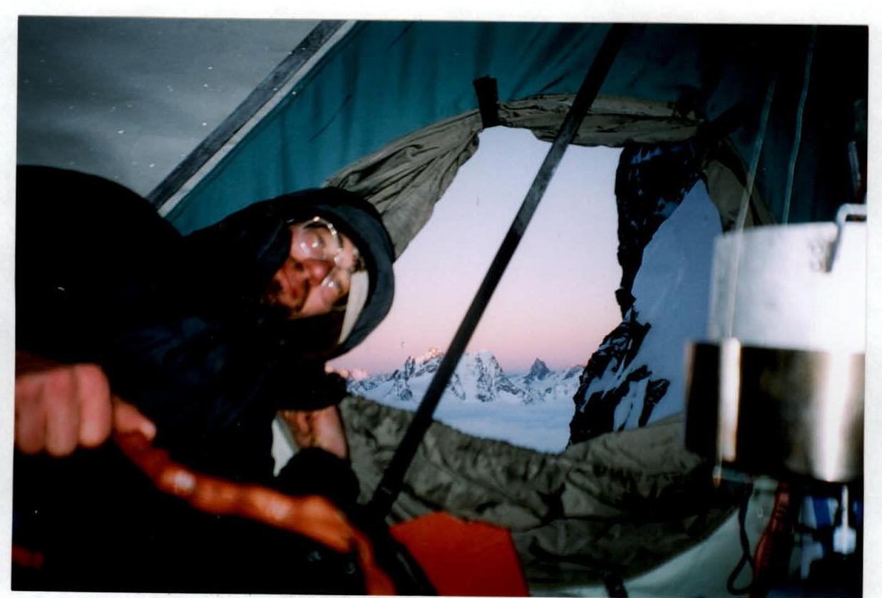
Overnight stay on section R6
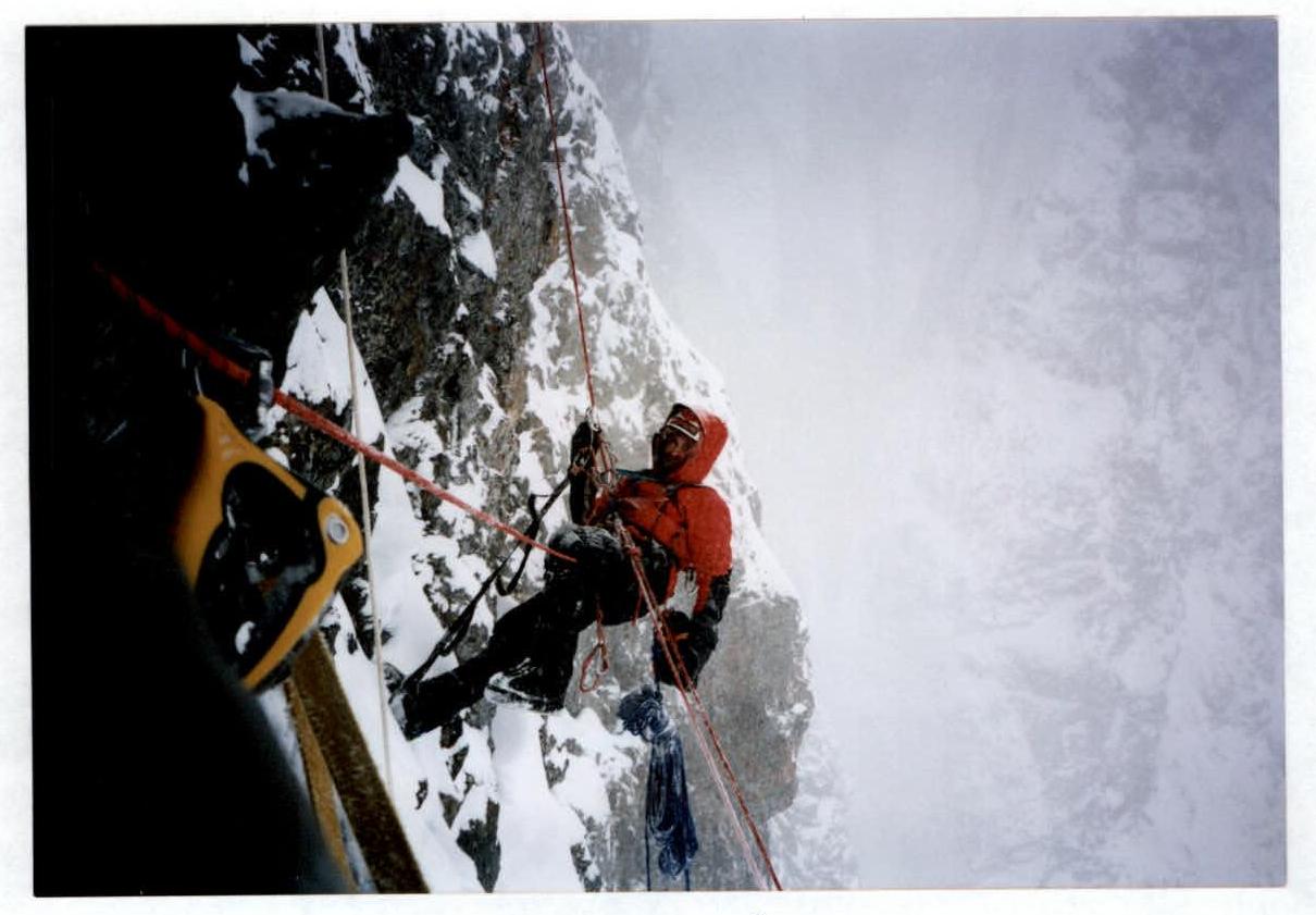
Section R6
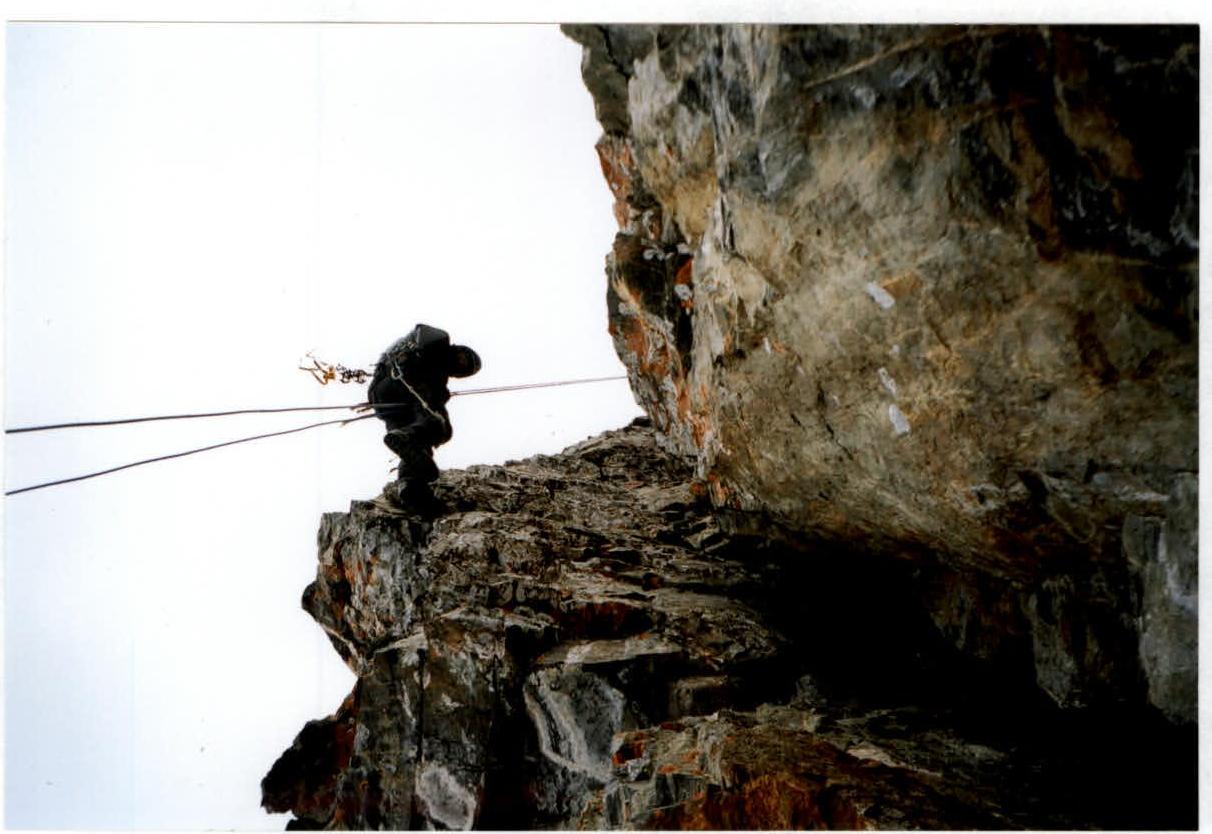
Section R13
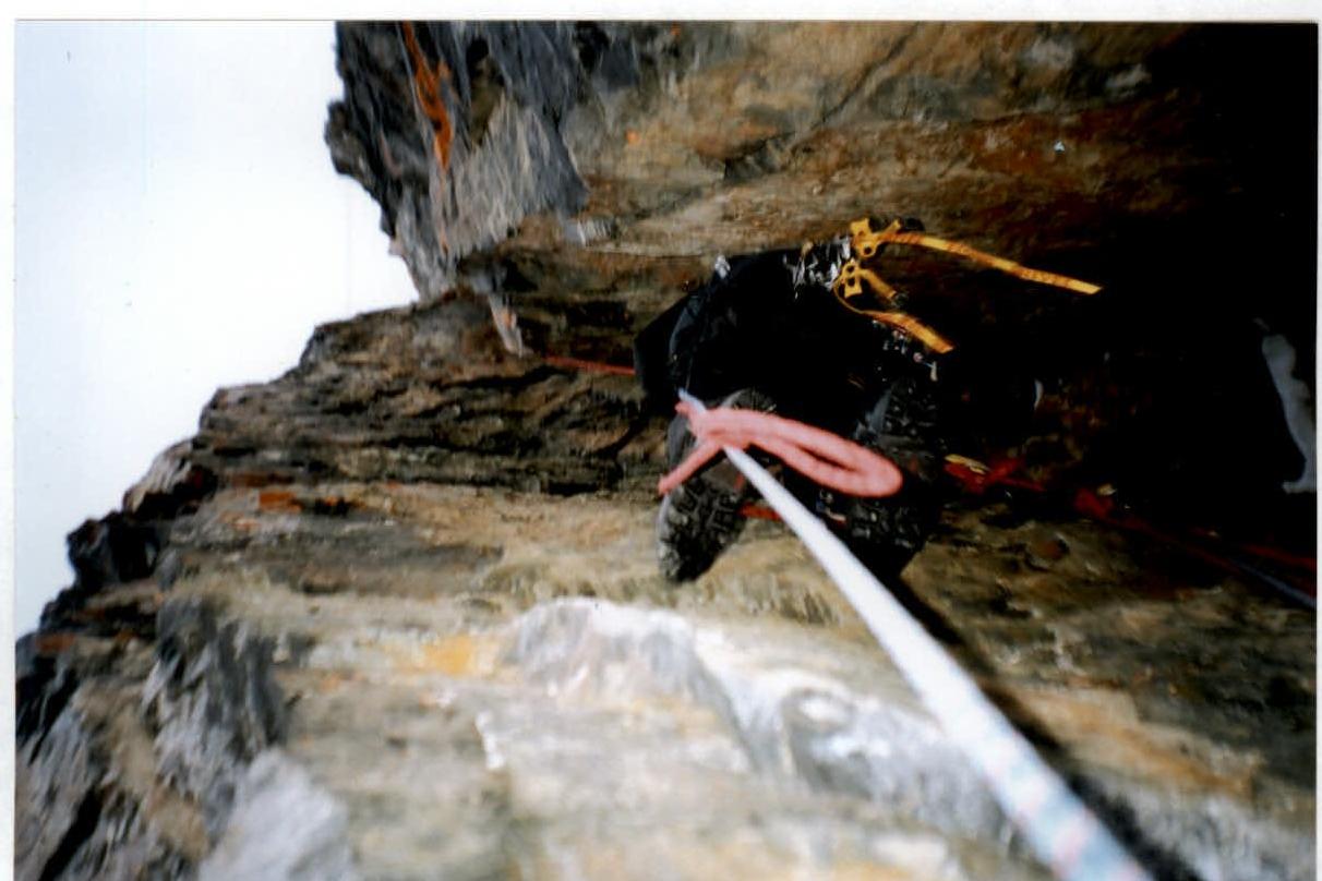
Section R12