PASSPORT
- Technical Grade
- Central Caucasus
- v. Chatyn (Main) via the "diamond" on the north wall (Myshlyaev's route)
- 6A category of difficulty
- Elevation gain — 800 m, length — 1000 m, length of sections with 5–6 category of difficulty — 450 m, of which 6 category of difficulty — 270 m.
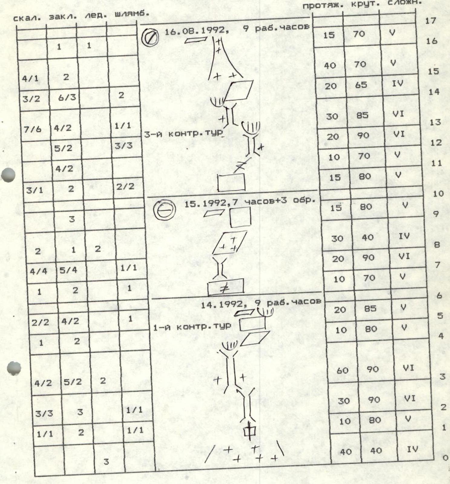
- Pitons driven:
| Rock | Bolt | Nuts | Ice screws |
|---|---|---|---|
| 37+10^ | 24^ | 67 | 23 |
| 26 | 18^ | 26 | 0 |
— reuse of previously driven pitons
- Team's travel time — 46 hours and days — 5
- Overnights: 1st, 3rd — sitting 2nd — comfortable on a snow- sculpted platform 4th — comfortable on a platform carved in a snowy ridge
- Participants:
- Antonov Sergey Vasil'evich CMS
- Lapin Yuriy Nikolaevich CMS
- Shtarkov Mikhail Lollievich CMS
- Coach: Aref'eva Rufina Grigor'evna
- Approach to the route: August 14, 1992. Summit: August 18, 1992. Descent: August 18, 1992.
- Alpine Club named after R.V. Khokhlov MSU
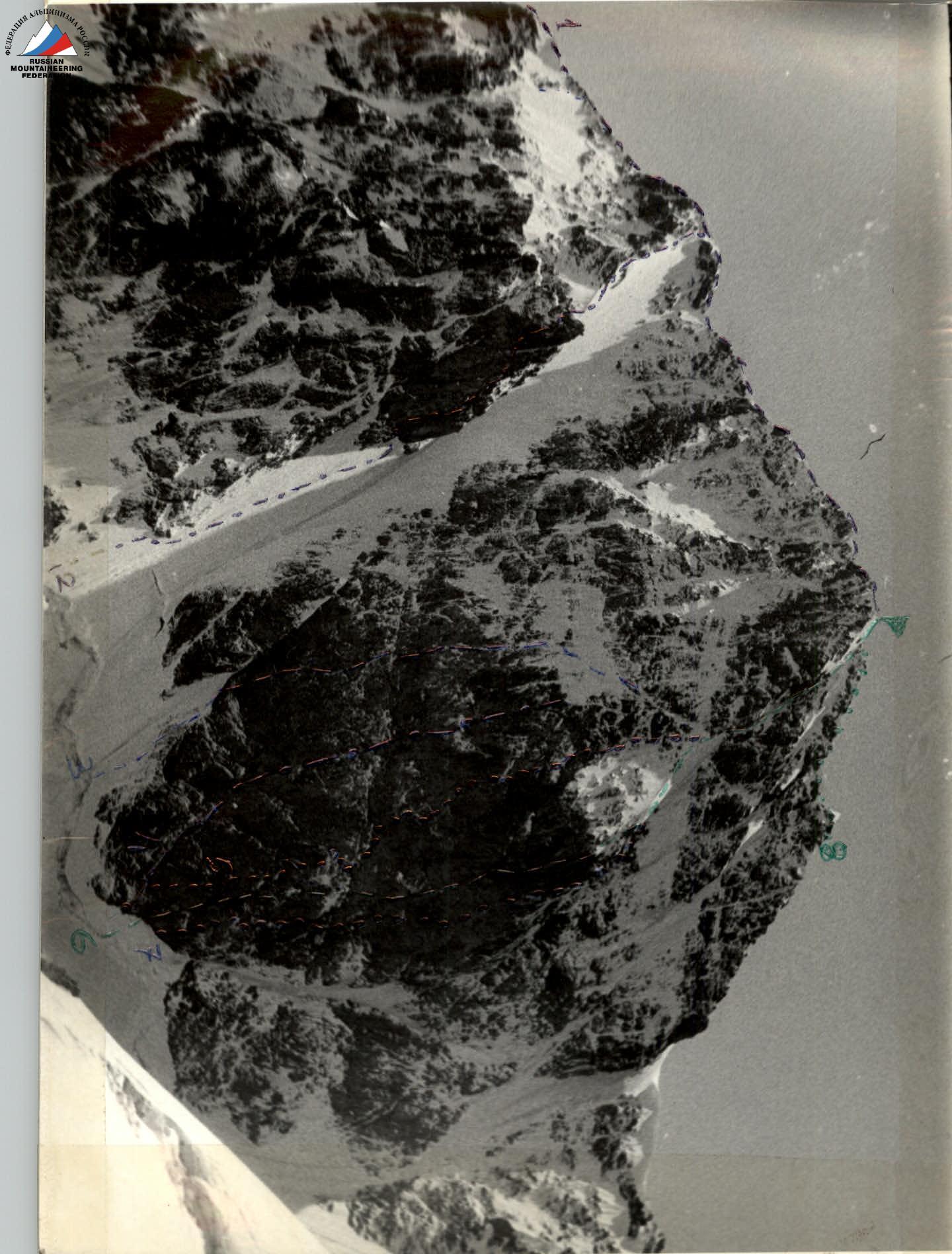
General Photo
- 1 — Solodtsev's route, 5B
- 2 — Garr's route, 5B
- 3 — Bolizhevsky's route, 6A
- 4 — Snesarev's route, 6A
- 5 — Chernoslivin's route, 6A
- 6 — Myshlyaev's route, 6A
- 7 — Grakovich's route, 6A
- 8 — Za k/tr (descent route) → team's path
Team's Tactical Actions
August 14. Approached the start of the route from the initial bivouac at Lozhny Chatyn pass and began moving up the route at 10:00. The bergschrund is snowed over and does not present difficulties. After climbing a rope length up the steep ice slope to the base of the "diamond", Shtarkov put on rock shoes and worked as the lead climber for the rest of the day. Movement was on a double rope. The lead climber went without a backpack. The second and third climbers ascended via top rope with top-rope protection. This tactic was used for the entire wall. Most of the bolt pitons were cut off, so protection was organized using regular pitons, making extensive use of friends, skyhooks, and petal-shaped pitons for progression. The chimneys were filled with ice, making climbing difficult, but ice screws went in well. Four rope lengths were covered in a day. Spent the night sitting on a small ledge just above the 1st control point.
Abalakova's ledge. Here, it remained to construct a snow platform, while Antonov and Lapin processed the route. The weather worsened. Snow grains were falling, and the rocks were wet. The middle chimney was filled with snow and ice, requiring the removal of entire blocks of snow. Two ropes were fixed — just above the 3rd control point.
August 16. Climbed the processed rope lengths. Lapin was the lead. It was cold, and the chimney was filled with ice, so Yura climbed in boots, often using artificial aids. The rocky couloir consisted of icy slabs:
- Initially climbed in crampons
- Then in galoshes
There was a lot of snow again in the upper part, and this section was climbed by Antonov first. The weather worsened again in the second half of the day. Set up a bivouac at the base of the upper chimney. There was a small platform for a sitting overnight stay.
August 17. Shtarkov led. The weather was poor from the morning. Very complex chimney climbing — 2 rope lengths, then a difficult wall was climbed using artificial aids, leading to the "roof". There was a real snowstorm at the top. Shtarkov changed shoes, and Antonov, in crampons, climbed 2 rope lengths up the snowy rocks to the snowy ridge. Here, in the ridge, we carved out a platform and set up a tent.
August 18. Strong wind and snow grains. Lapin worked as the lead first, then was replaced by Shtarkov. Each had a backpack. Had to wait out strong gusts of wind. Reached the summit at 16:00. Did not linger, as the ice axes were "ringing". Descent was via route 3A to the Ushba plateau. Reached the plateau in 2 hours and, as everything was in "milk", set up a tent. Descent through the Ushba icefall was on the following day.
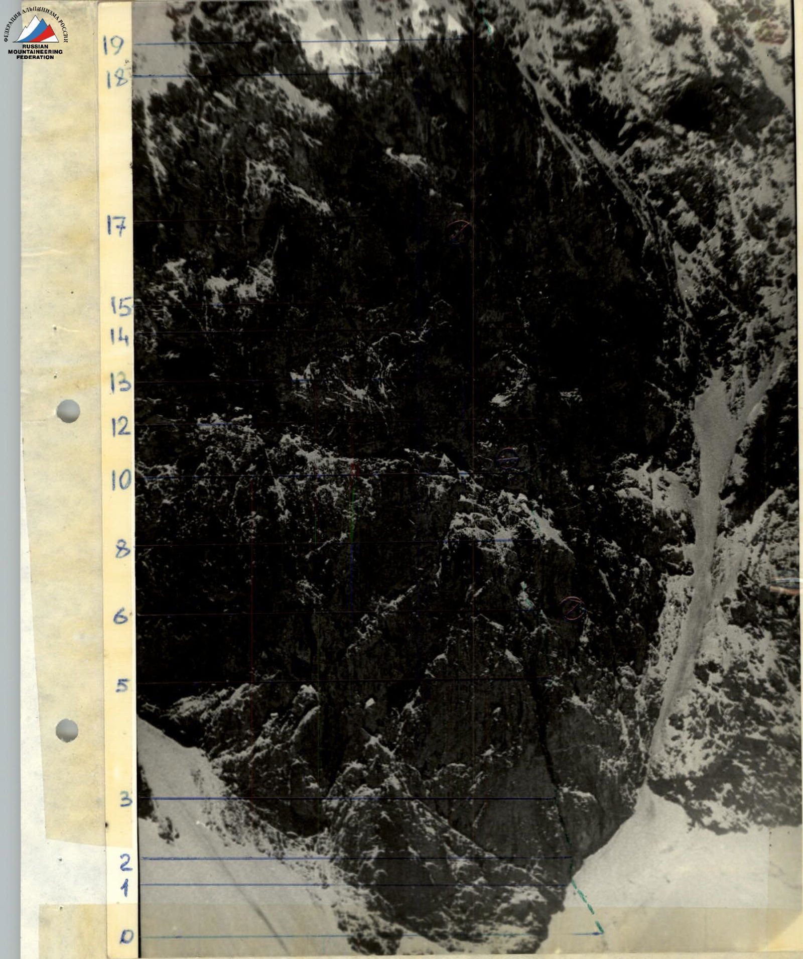
Technical photo.
ROUTE SCHEME IN UIAA SYMBOLS

Route Description by Sections
0–1. Steep ice-snow slope from the bergschrund to the base of the lower chimney. 1–2. Crack (artificial aids). 2–3. Difficult chimney, wet rocks. 3–4. Vertical icy chimney. The overhanging section is bypassed on the right. 4–5. Up to the right on a steep slab to a sloping ledge. 1st control point. 5–6. Difficult wall ends with a small ledge protected by a cornice — a place for a sitting overnight stay. 6–7. Left on the wall with a crack to the base of the chimney. 7–8. Difficult wet narrow 20-m chimney. 8–9. Snow-covered rocks — Abalakova's ledge. 9–10. Up the wall under overhanging rocks and traverse 10 m to the left to a platform. Bivouac site. 2nd control point. 10–11. From the platform, return to the right and then up the wall. 11–12. Up the crack to the right under the base of the middle chimney. 12–13. Up the icy and snow-filled chimney, under overhanging rocks, and difficult exit from the chimney to the left. 3rd control point. 13–14. Up the 30-m narrow chimney filled with snow and ice, bypassing the overhanging section on the right, to a sloping ledge. 14–15. Up the broken rocks to a vertical couloir. 15–17. Up the snowy couloir to a small ledge to the left of the upper chimney. Sitting bivouac. 4th control point. 17–18. Very complex upper chimney. 18–19. Up the difficult overhanging wall to the "roof". 19–20. Up the snowy rocks to a snowy ridge. Bivouac. 20–21. Snow-ice ridge leads to a broken rocky belt. 21–22. Up the icy couloir. 22–23. Up the snowy rocks of the ridge to the summit.