Ascent Passport
- Technical class
- Central Caucasus
- Ushba South peak 4710 m via the right part of the 103 wall (Kustovsky's route 7)
- Category of difficulty — 5B
- Height difference — 1450 m, length — 2170 m
Length of sections with 5–6 category of difficulty — 700 m. Average steepness of the route — 56°. Average steepness of the main sections — 80°
- Pitons hammered:
| rock | bolt | chocks | ice screws |
|---|---|---|---|
| 169/62 | 4/4 | 110/49 | 9/0 |
- Team's total climbing hours — 39 hours, days: 3 days
- Overnights: 1, 2, 3 — on platforms; comfortable, 3rd — on descent.
- Team leader: Kudryavtsev Valentin Alexandrovich — CMS
Team members: Fursov Valery Alexandrovich — CMS, Domrachev Sergey Ivanovich — CMS, Kruglovenko Alexander Vasilyevich — CMS, Shilo Vladimir Fedosovich — CMS. Team coach: Kudryavtsev Valentin Alexandrovich — CMS. Departure to the route: July 28, 1988. Summit: July 30, 1988. Return to base: August 1, 1988.
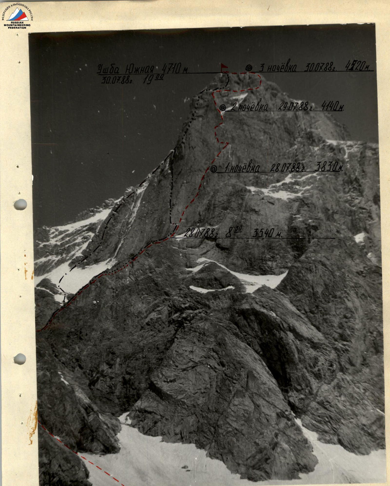
Photo II. July 27, 1988, 14:00. General view of the route. Camera “Smena-Symbol”. Lens T-43U LOMO. Focal length 40 mm. Distance to the object 400–600 m.
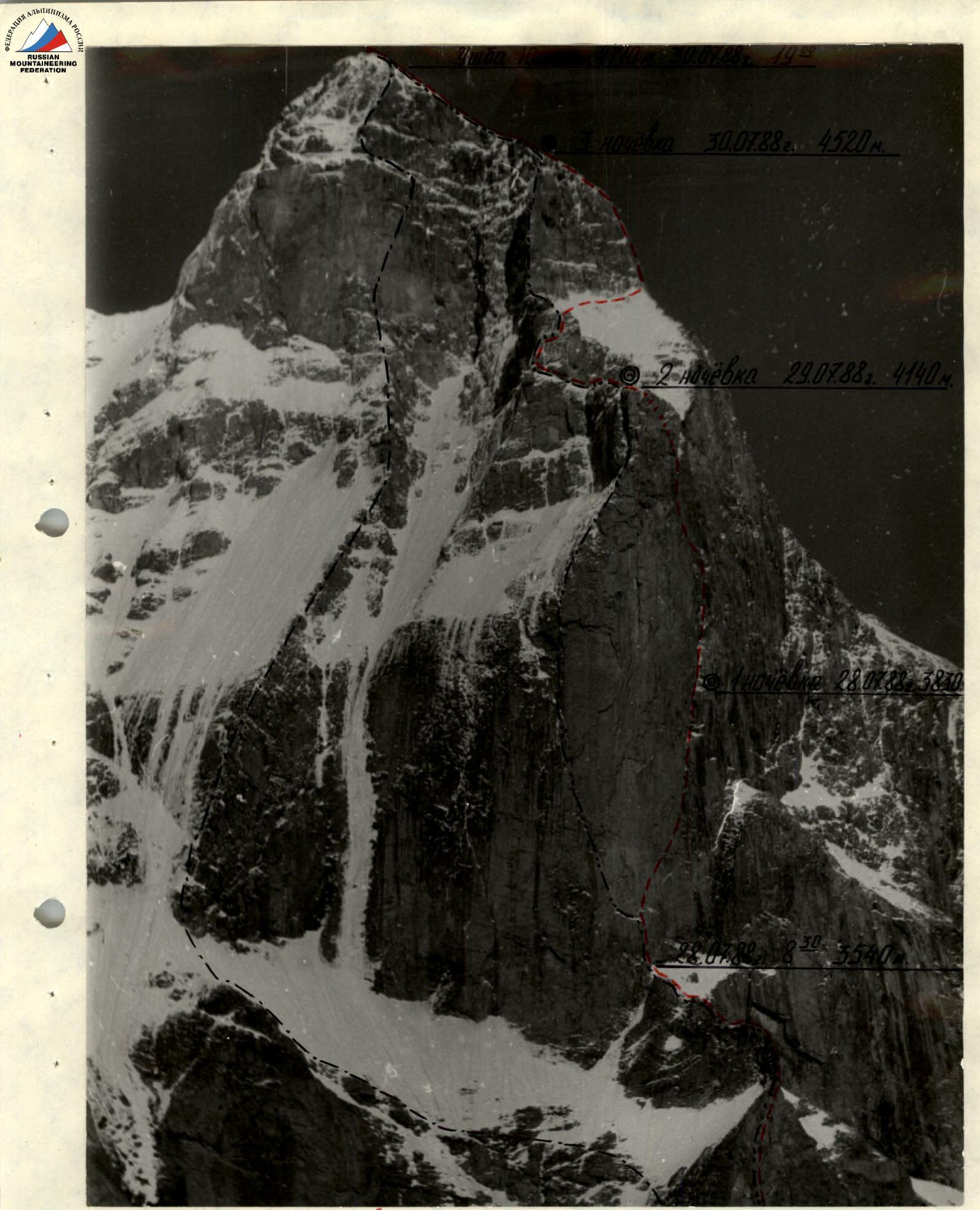
Photo 10. July 26, 1988, 15:00. Route profile from the left. Camera “Zenit-EM”. Lens “Jupiter-37A”. Focal length 135 mm. Distance to the object 2–2.5 km.
Team's Tactical Actions
While preparing for the route and studying the reports of previous climbers and consultations, the team came to the conclusion that they would be able to complete the route with four overnight stays. Two reserve days were planned in case of bad weather.
The route was conditionally divided into four sections:
- Section I — Ushba glacier and ridge leading to the base of the "pillar".
- Section II — "Pillar".
- Section III — Upper rock belt.
- Section IV — "Roof".
The problematic section is the "pillar", where the team applied the entire arsenal of modern mountaineering techniques: sky hooks, hooked pitons, bolt "equipment", etc. The team had 4 × 50 m of main rope, each working on a double rope. All team members had standard shock absorbers. The first climber worked without a backpack, and the second — with a lightened backpack. To ensure guaranteed safety, an emergency reserve of equipment and supplies was prepared and distributed among the backpacks.
On the route, the team worked in two teams: Fursov — Kudryavtsev, Krugolvenko — Domrachev — Shilo. The team started working on the route on July 28, 1988, and reached the summit on July 30, 1988, at 19:00. The total time spent on the route was 39 climbing hours with three overnight stays. The time breakdown for the route passage is as follows: July 28, 1988, from 4:00 to 20:00 — passage of sections R1–R15; July 29, 1988, from 8:00 to 20:00 — passage of sections R15–R19; July 30, 1988, from 8:00 to 19:00 — passage of sections R19–R26 and reaching the summit.
The first section is a closed glacier leading to the base of the rock ridge, which leads to the "pillar". The ridge has a section of two rope lengths of 4–5 category of difficulty and about 300 m of 2–3 category of difficulty.
The second section — "pillar" — is extremely difficult climbing, sometimes on the verge of a fall, with wide application of IT. Climbing is further complicated by the fact that the route is washed with water, and in the first half of the day, the rocks are covered with ice.
The third section — the upper rock belt — is difficult climbing of 5–6 category of difficulty with the use of IT.
The fourth section — "roof" — is simple snow-covered rocks of 2–3 category of difficulty, turning into a narrow snow ridge leading to the summit of Ushba South.
During the ascent, three overnight stays were organized:
- The first overnight stay on section R13,
- The second on the "roof" of the pillar, section R19,
- The third on the "roof", section R26.
All overnight stays were comfortable, lying down. The preliminary tactical plan provided for the passage of the route with four overnight stays. The team completed the route with three overnight stays (39 climbing hours), which is explained by the correctly chosen tactical scheme of movement of the teams (the first worked without a backpack, the second — with a lightened backpack, lifting backpacks "American-style" and pulling out backpacks using a special block).
For overnight stays, the group had five down-filled sets and two bivouac polyethylene tubes. For the ascent, 16 kg of food were taken, calculated at 540 g per person per day. Each person had an individual pocket ration. Hot meals were organized in the morning and evening, and during the working day, the team gathered once for a snack.
Radio communication with observers was carried out using the "Lastochka" radio station, for which a spare power supply was taken. There were no radio communication failures or missed sessions during the ascent. Throughout the entire ascent, the group was visually monitored by observers using 8x binoculars.
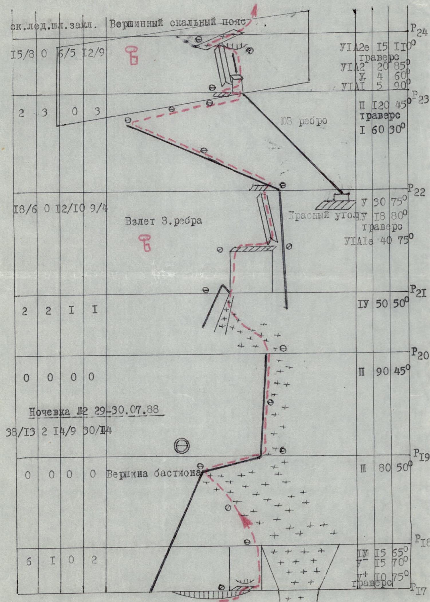
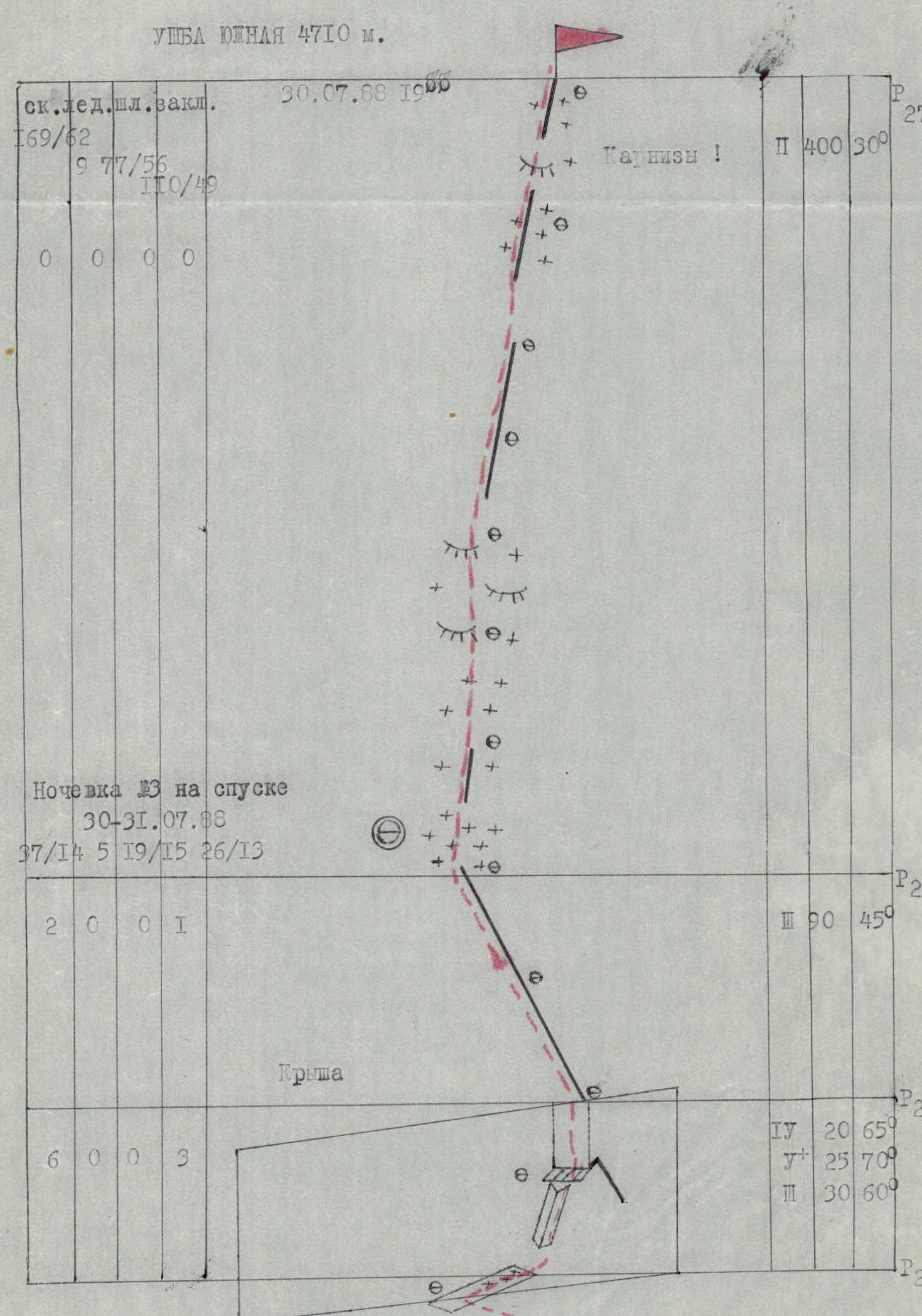
Route diagram in UILA symbols M 1:2000
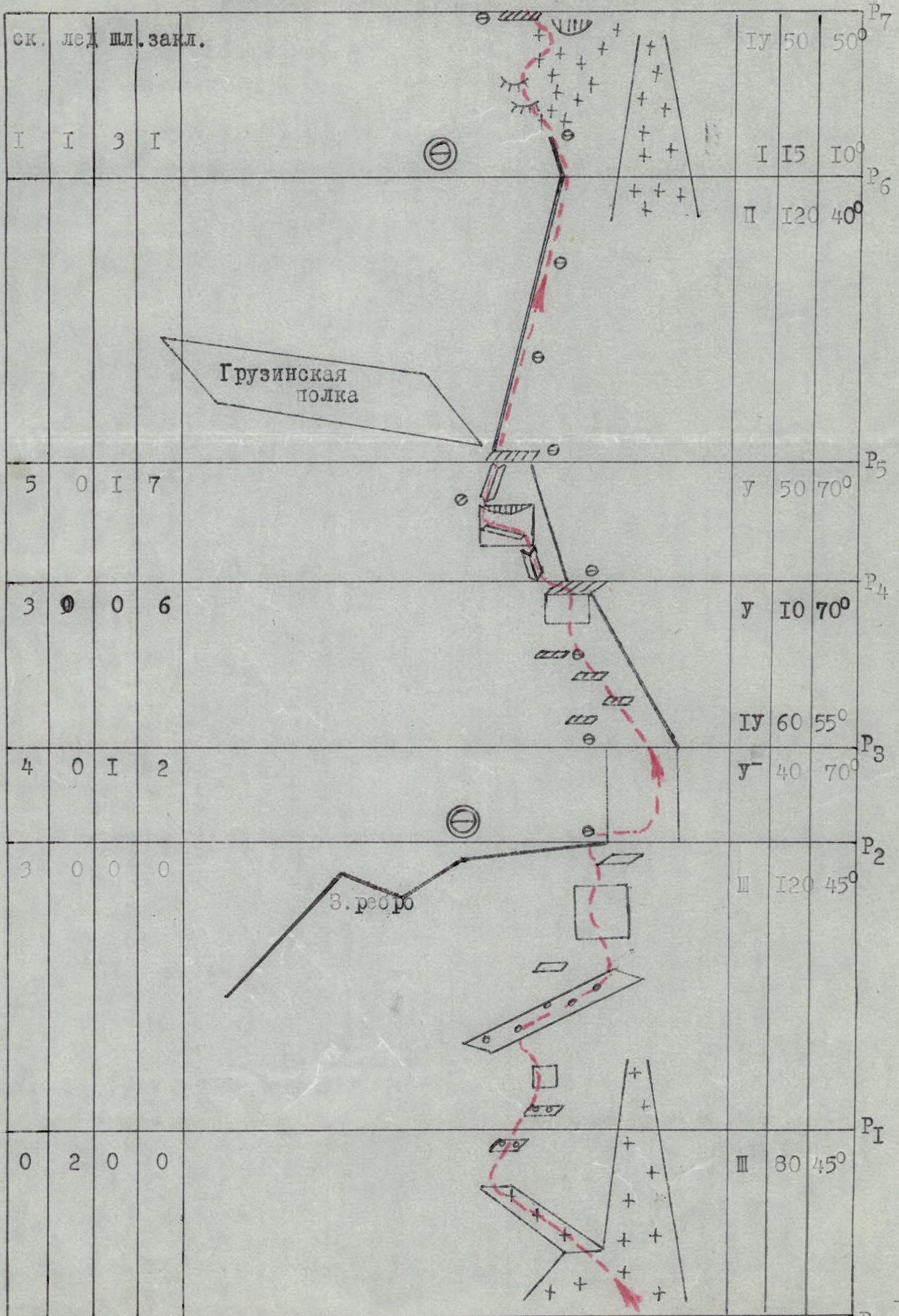
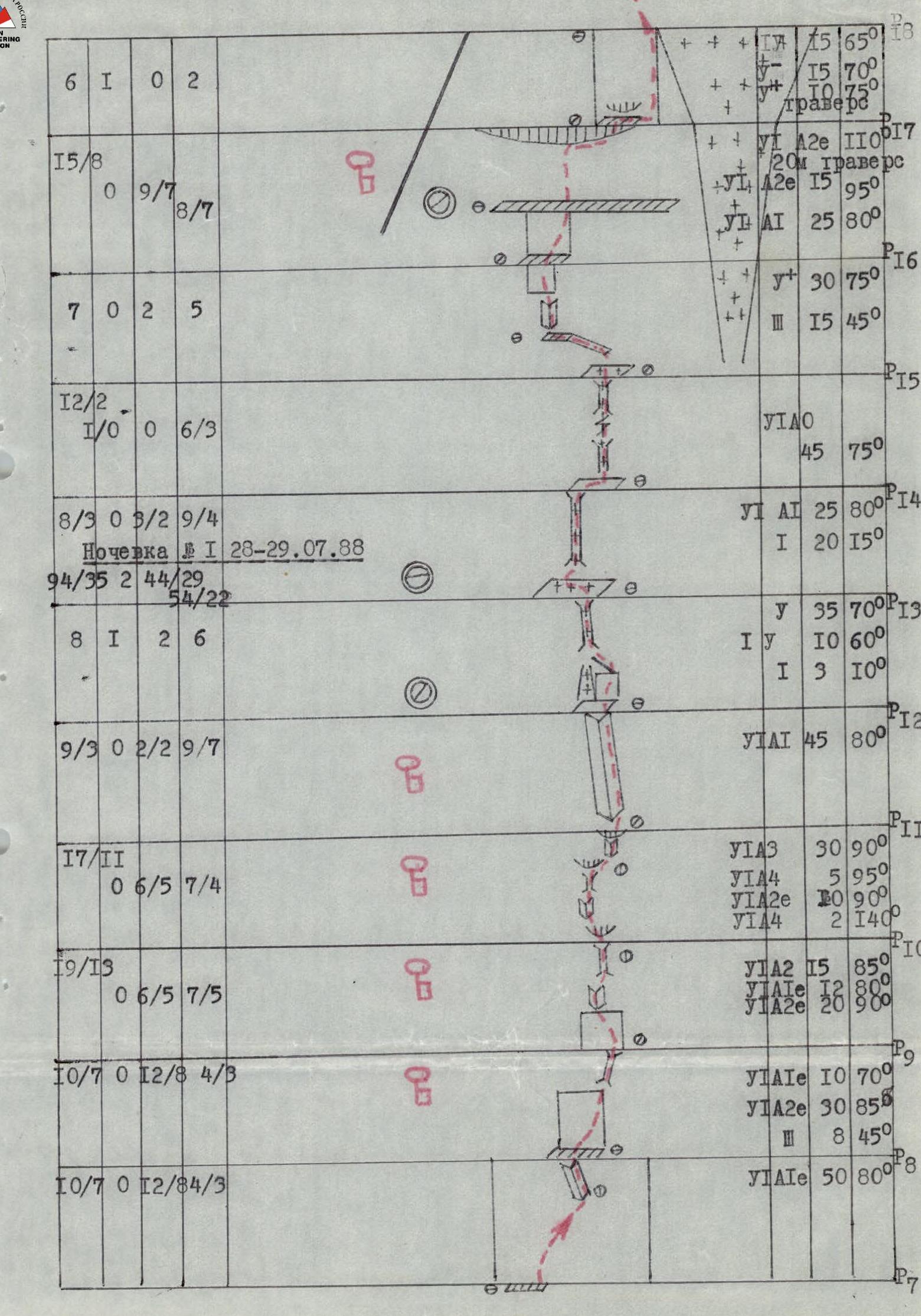
Route Description by Sections
The assault bivouac was located on the Ushba glacier at an altitude of 2630 m. The observation and communication group was located on overnight stays on the "ram's foreheads", from where the route and a large part of the planned descent route were clearly visible.
The ascent to the route passed along the slopes of Mt. Mazeri, bypassing crevasses, with an exit under the couloir descending from the lower third of the West Ridge (altitude 2950 m).
The route initially follows the W. ridge, then the first rock belt, which is a bastion with a steepness of 80° and a height difference of 550 m. Further ascent goes along the W. ridge with a 70-meter wall of 75° steepness, abutting the summit rock belt with a steepness of 70–75° and a height difference of 120 m.
Day 1. July 28, 1988.
Section R0–R1. Steepness 45°. Snow slope and snow-covered ledge. Passed in crampons, insurance through an ice axe in the lower part and ice screws on the ledge.
Section R1–R2. Rubble and destroyed rocks with numerous ledges, some iced, leading to the snow-covered W. ridge.
Section R2–R3. Steep ridge ascent of 70°. Passed with free climbing. Rocks are monolithic with sufficient cracks.
Section R3–R4. Left slope of the ridge with ledges in the lower part and a 10-meter difficult wall at the exit to the ridge platform.
Section R4–R5. Oblique traverse of the left side of the ridge under an overhanging ridge along a narrow ledge.
Section R5–R6. Gentle ridge. Passed simultaneously. To the left below is a snow plateau, under which the Georgian ledge passes. At the end of the ridge is a convenient bivouac site.
Section R6–R7. Horizontal 15-meter section of the ridge, continuing with a steep left slope. To the left is the exit of "ram's foreheads". The slope approaches the base of the bastion. To the right is the left couloir. Passed alternately with insurance through ice screws and pitons on the bastion.
Section R7–R8. Beginning of the bastion. Monolithic wall with few holds. In the upper part of the section is an inner corner, passed with difficult free climbing.
Section R8–R9. Starts with a ledge for two. Further, a monolithic wall with few holds and cracks. At the end of the section is a wide chimney, passable with IT. Old bolt pitons are present.
Section R9–R10. Monolithic wall with an inner, widely deployed inner corner, turning into a chimney. Under the chimney is a cornice. Insurance points are hanging. The cornice is overcome head-on with IT. Large and medium chocks go well.
Section R10–R11. Coarse-relief wall with a limited number of cracks and holds. Two overhanging sections. Rocks are wet. Passed with IT. Cracks are shallow, blind.
Section R11–R12. 45-meter inner corner with ice and wet rocks. There are sufficient cracks, but most are filled with ice. The corner leads to a small snow-covered platform.
Section R12–R13. Heavily dissected slope with a possible bivouac site. Rocks are covered with ice. Live rocks! Wide, safe bivouac platform. Water is present. The platform was cleared of snow and ice. An overnight stay was organized.
Day 2. July 29, 1988.
Section R13–R14. Icy chimney. Passed in crampons. Cracks are present for wide chocks.
Section R14–R15. Chimney interrupted by a narrow slit. The section is water-soaked. The upper platform of the chimney is covered with a continuous layer of ice. Above us is the left edge of a funnel from which water flows.
Section R15–R16. Turn left onto a ledge. Here, under overhanging rocks, it is almost dry. A convenient insurance site. A sitting bivouac is possible. From the ledge to the left is an overhanging inner corner. M6. Old bolts. Further, a destroyed wall with abundant microrelief and a small ledge for an insurance point. Water drips from the top of the bastion. The weather starts to deteriorate.
Section R16–R17. 15-meter overhanging wall. Passed along a barely visible ledge using M6. Above the wall is a wide, long horizontal ledge. The ledge narrows towards a funnel. Above it looms the top of the bastion. Water flows fly over the ledge. From the ledge, along an overhanging wall under a cornice and under it, a traverse to the right to its edge. The wall, traverse, and exit to a ledge for one under the next cornice are passed with M6. The insurance point on the section is hanging, through an old bolt. Organizing reliable insurance is problematic. The last one needs to organize a rope pull when traversing the section.
Section R17–R18. The cornice above the insurance point is bypassed to the right, exiting to the edge of the funnel. Further, left — up. A straightening of the rope by the first climber is necessary. On sections R16–R18, there is a limited number of cracks. Cracks are shallow, blind. Water flowing from the roof of the bastion floods the route.
Section R18–R19. Steep snow slope. Insurance through an ice axe. At the end of the section, in a snow pocket, is a convenient bivouac. An overnight stay was organized.
Day 3. July 30, 1988.
Section R19–R20. Simple, gentle ridge. Simultaneous movement.
Section R20–R21. Traverse left under a rock along snow and ice. Insurance from rocks through pitons and ice screws on the slope.
Section R21–R22. Monolithic wall. The first 6–7 m are M6 on old bolts. Further, free climbing. Large chocks are widely used. A semi-convenient insurance point on a chip for two. From the insurance point, a 20 m traverse to the right along a narrow, intermittent ledge. Further up to the summit ascent. M6.
Section R22–R23. Serpentine traverse from left to right onto a wall under the summit bastion. Insurance through an ice axe.
Section R23–R24. To the right along a crack from a large inner corner under an overhang. Under the overhang is a very difficult traverse of 12–15 m. M6. Insurance point on an inclined slab. Convenient.
Section R24–R25. To the right — up along inclined slabs and steep rocks onto the roof. Free climbing with a large number of holds. Insurance mainly through chocks.
Section R25–R26. Simple rock ridge. Simultaneous movement.
Section R26–R27. Snow-covered rock ridge. Before exiting to the summit — cornices!!!

Photo 19. Passing the rope on section R8–R9. Transportation of a backpack "American-style". Camera “Smena-Symbol”. Lens T-43U LOMO. Focal length 40 mm. Note: All subsequent photo illustrations were taken with the same camera.
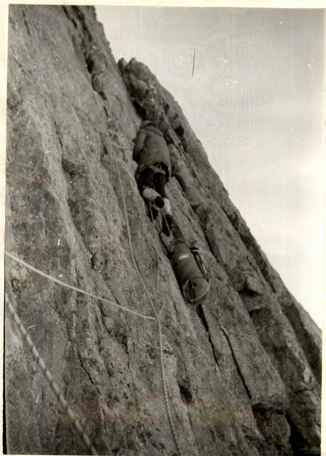
Photo 14. Passing the rope on section R10–R11.