Moscow Alpine Championship 2016 High-altitude Technical Class
Report
On the ascent to Ushba South (4710 m) via the left part of the southwest wall (Myslyaev's Route) 6A category of complexity
The teams from the Mountain Club "Alpindustria" together with the Alpine Federation of Samara Region on August 19–22, 2016
Moscow 2016
Ascent Passport
- Class — technical.
- Central Caucasus, Prielbrusye, Ushba Ridge of the Main Caucasian Range.
- Ushba South, 4710 m, "Along the left part of the southwest wall", Lev Myslyaev's route.
- Category of complexity 6A.
- Route character — combined.
- Route characteristics:
- Height difference (glacier — summit) — 1700 m
- Length of 5–6 pitches — 650 m
- Average steepness of the "Pillar" section R12–R29 — 70°
- Insurance points used:
| For insurance | For ITO | Left on the route | |
|---|---|---|---|
| Ice screws | 16 | 0 | 0 |
| Anchors, shлямбуры | 100 | 7 | 2 |
| Friends, placements | 120 | 0 | 0 |
| Total | 236 | 7 | 2 |
- Team's total hours — 33 h; 3 days.
- Exit to the route from the base camp — on August 19 at 6:00. Height 2400 m.
Exit to the "Georgian Shelf" — on August 19 at 18:00. Height 3450 m. Exit to the bivouac under the Pillar's top – on August 20 at 19:00. Height 4050 m. Summit exit – on August 21 at 16:20. Height 4710 m. Descent to the bivouac on the Pillar's top – on August 21 at 23:30. Descent to the glacier – on August 22 at 18:20.
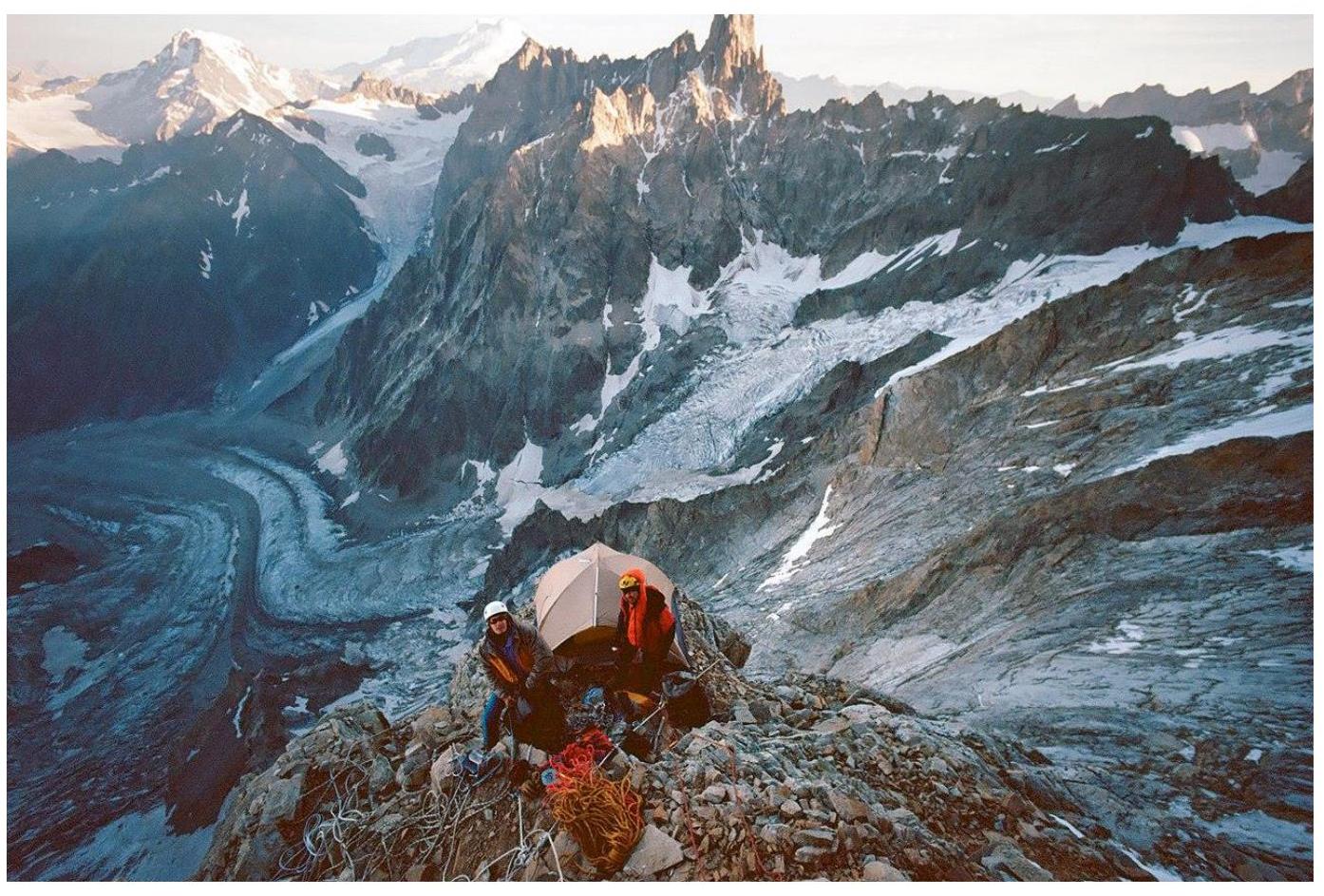
- Bivouacs:
2 — in a tent on shelves (first on R10, second on R23). On descent, also a bivouac on R23.
- Team leader:
Markevich Konstantin (MS). Team members:
- Skotnikov Dmitry (CMS)
- Kurochkin Alexey (1st sports category)
Description and Scheme of the Area
Ushba mountain ("Witches' Sabbath" in Georgian) is located at the very end of the Shkheldinsky gorge, on the border between Russia and Georgia. The Ushba massif consists of two peaks — North (4690 m) and South (4710 m). They are connected by the Ushba Saddle or "pipe", so named not without reason: even in good weather, it is windy. Ushba is considered one of the most challenging "four-thousanders" in the world. The easiest route to North Ushba is 4A, to South Ushba — 5A. The slopes of the massif on all sides break off with steep 1000–1500-meter walls, along which there are:
- thirteen 6A routes
- eighteen 5B routes
- four 5A routes
- two 4A routes
The nearest settlement to Ushba is Mazeri. From it, a marked trail goes up along the Guichala river. After the second river crossing, the trail rests against a border outpost, from which the trail goes up, leaving picturesque waterfalls to the left and rests against the Ushba glacier. The base camp is located in the moraines at the end of the glacier.
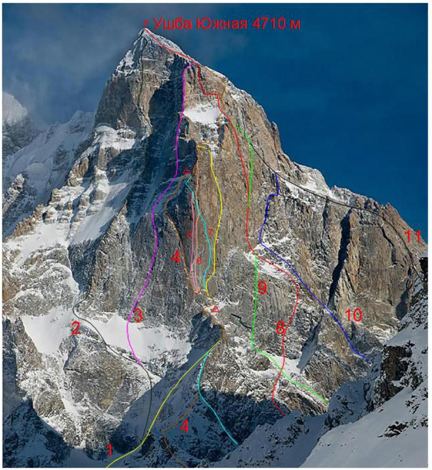
| № | Route name | Route author | Year | Cat. sl. | |
|---|---|---|---|---|---|
| 1 | Along the right part of SW wall | A. Kustovsky | 1963 | 6A | |
| 2 | Along SW edge | Yu. Grigorenko-Prigoda | 1972 | 6A | |
| 3 | Along the left part of SW wall | M. Zholobov | 1990 | 6A | |
| 4 | Along the left part of SW wall | L. Myslyaev | 1960 | 6A | |
| 5 | Along the centre of SW wall | N. Golubev | 1981 | 5B | |
| 6 | Along the centre of SW wall | variant by M. Voloshanovsky | 2010 | 6A | |
| 7 | Along the centre of SW wall | V. Monogarov | 1965 | 5B | |
| 8 | Along SW wall | O. Khvostenko, variant by A. Moshnikov | 2011 | 6A | |
| 9 | Along SW wall | E. Titkin | 1984 | 5B | |
| 10 | Along SW wall | V. Monogarov | 1960 | 5B | |
| 11 | From Guli glacier | A. Dzhaparidze | 1943 | 5A |
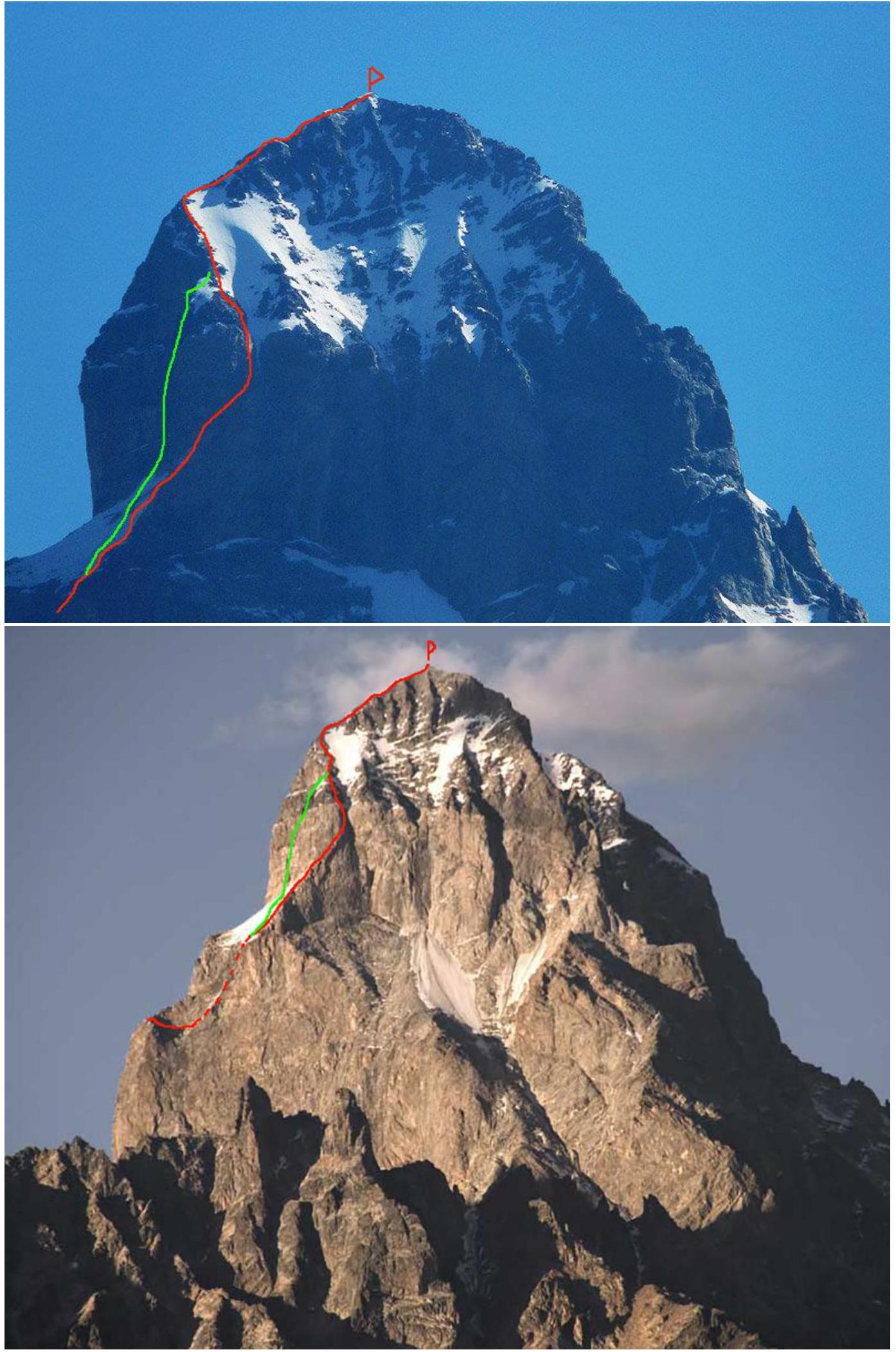
The photo is by Alexander Neskorodov. The ascent and descent route of the team.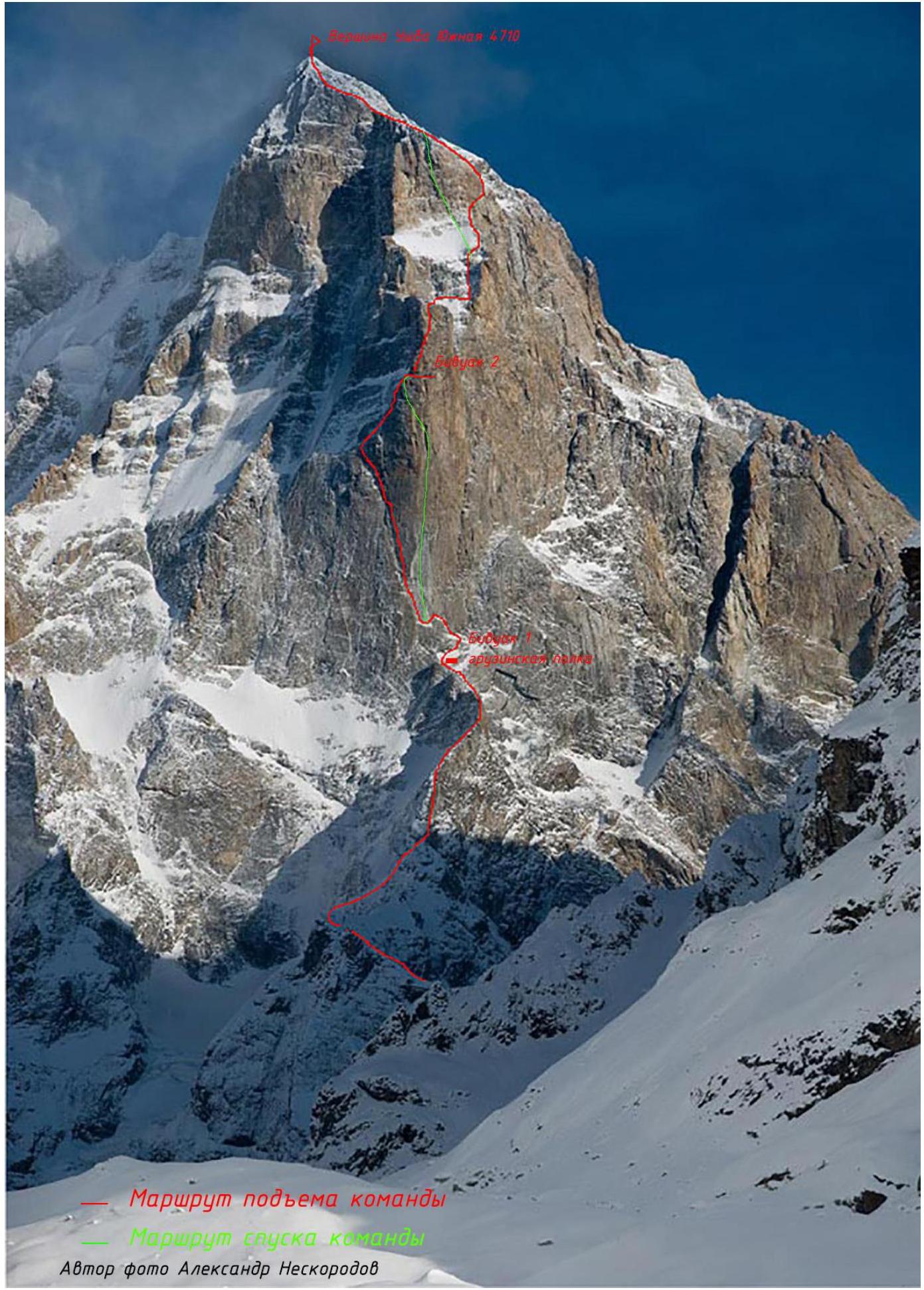
Team's Tactical Actions
The choice of the ascent route was based on several positions:
- Safety of ascent and descent;
- Fast passage, minimizing the risk of getting into bad weather;
- Passage of the route with free climbing, without using complex ITO (skyhooks, shлямбуры, etc.);
- Availability of shelves for overnight stay in a tent;
- Absence of the need for long processing: 3 ropes were used on the route. Lev Myslyaev's route is interesting primarily because of the wall part of the "Pillar", which is a huge internal corner turning into a chimney. The relief is quite diverse for using the entire arsenal of insurance points during trad climbing: placements, friends, anchor hooks. The approach to the beginning of the wall part is not technically difficult, but it is quite long, and you have to move with simultaneous and alternate insurance. The supply of provisions was taken with the expectation of possible waiting out bad weather on the "Georgian Shelf" for 4 days. After analyzing the reports of ascents by other teams to Ushba South via the "Pillar", as well as studying the statistics on weather conditions during ascents, the following tactics for passing the route were chosen:
On August 17, a заброска was made under the start of the route, and a safe and easiest path along the glacier and ascent to the ridge was scouted.
On August 18:
- waited out bad weather in the base camp
On August 19:
- left the base camp at 6:00
- approached the start of the route to the заброска at 8:00
- moving mainly simultaneously (there are 2 climbing sections of 5th category of complexity on the upper part of the narrow ridge), reached the bivouac ("Georgian Shelf") by 18:00
- processed 3 sections on the Pillar (approached the beginning of the internal corner and straightened the perils to the bivouac)
- Markevich K. led the processing.
Additionally:
- there are old descent perils from the wall to the bivouac
- left most of the provisions and some equipment on the "Georgian Shelf"
On August 20, they started working at 7:00. At 17:00, they reached the gentle part — a slope, along which they climbed through 4 sections to the bivouac under the Pillar's top at 19:00. Markevich K. led throughout the day. On the Pillar, they found left dюльфер ropes. The slope after the wall part is stone-dangerous and represents "ram's foreheads" and stones lying on them. There are few places for reliable insurance points. It is more logical to move first to the left towards the centre of the slope, and then to the right up to the ridge of the Pillar and to the bivouac (landmark — a shelf in the ridge against the background of the sky).
On August 21, having received a favourable weather forecast via satellite communication and based on consultation, it was decided to climb to the summit and descend to the bivouac in one day. They left the bivouac and provisions at bivouac №2. They started on the route at 7:00. At 8:20, they began working with mixed ropes. At 12:00, they approached the upper rock bastion. Further, the route goes along a slanting narrow shelf, bypassing the bastion to the right, 45 m long. Then up and to the right, another 2 ropes in the direction of the snow couloir. Along the ascent path, they encountered "native" iron. By 15:20, they reached the pre-summit ridge. Having decided on the place to start the descent and leaving unnecessary equipment, they moved up along the ridge and an hour later, at 16:20, were on the summit. They found a note from Georgian climbers (route "Kharakternik"). 10 minutes later, they began their descent.
On the upper bastion, the descent route goes along the "rusty corner". Further down to the bivouac, they descended along the ascent path. On the ice, they used a self-unwinding knot, but the ice condition worsened by evening, and they began to use expenditure loops made of rep cord on rock ledges. From the Pillar's top to the bivouac, there were "native" perils, which they used to speed up the descent. They descended to the bivouac at 23:30. Skotnikov D. led throughout the day.
On August 22, they started their descent at 7:00. To the chimney in the centre of the Pillar, along Monogarov's route, there are "native" perils. Strengthening the stations and duplicating the perils with their ropes, they descended to the "Georgian Shelf" by 15:30. At 16:00, they began their descent along the ridge towards the glacier (3 perils were laid). When descending, it is necessary to stay on the left side of the ridge, but not to stray far from it. The movement is simultaneous, there are 4 dюльфера. The descent is along the ascent path. They descended to the glacier at 18:20. At 22:00, they descended to the base camp.
Communication with the base camp was carried out by radio (144 MHz band). The observer in the base camp was Natalia Protchenko, who was able to call rescuers from KSP (the group registered their exit). To be on the safe side, they maintained radio communication with the Glebov, Sobolev, and Udovenko group, who were climbing Ushba North via route 4A. Additionally, the group had a satellite phone. Above the Pillar, there is sometimes a connection via a cellular phone. The weather during the ascent was clear, the wind was weak, and the forecast received via satellite communication was fully justified. The condition of the rocks allowed them to climb almost the entire route with free climbing. (There is a lot of ice on section R18–R19). It is advisable to take portable radios for communication between the leader and the belayer, as there are places where it is very difficult to shout to the partner.
Water on the route:
- On the first bivouac, a small stream flows from under the wall
- From the "Georgian Shelf", you need to climb up and go to the right towards the beginning of Monogarov's route, about 1.5 ropes along rocks of 2–3 category of complexity.
- On the second bivouac, there is snow on the slope to the left of the bivouac. The amount of snow can strongly depend on the weather.
- There is water everywhere above the Pillar.
Additional bivouacs:
- Prepared sites are available when ascending from the glacier at the beginning of the ridge, on the Pillar's top, and at the beginning of the wide pre-summit ridge.
- All bivouacs are located in windy places; it is recommended to pay attention to securing the bivouac.
Description of the Route by Sections
Approach from the Glacier to the "Georgian" Shelf
R0–R1: From the base camp, ascend along the moraine, then move along the Ushba glacier, turning to the right, cross the moraine, and move up to the right towards Mazeri peak. Along the least steep ascent of the glacier, approach the wall of Mazeri and, bypassing the central part of the glacier to the right, move towards the ascent ridge of Ushba South. The entrance to the ridge is along a wide talus slope with a steepness of about 30°.
R1–R2: Up along the large-talus slope, starting to the right and then traversing to the left along simple rocks 200–250 m, up to the point of the ridge. 400 m, 2 category of complexity.
R2–R3: Turn to the right, facing the "Pillar", and, sticking to the point of the ridge 300–350 m (2–3 category of complexity), approach the 1st 40-meter ascent of the ridge.
R3–R4: Up along a simple wide chimney (4A–4B) 10–12 m, then simple (2–3 category of complexity) rocks 12–15 m, then left and up 15–20 m of the same rocks lead to the top of the ascent.
R4–R5: 20–25 m simple descent to the northeast, onto a flat snowfield. Here is a good bivouac.
R5–R6: 100 m along a simple horizontal ridge, approach the 2nd ascent.
R6–R7:
- At first, 30 m of simple (4A–4C) rocks,
- then traverse to the left before the internal corner and further to the left up 10–12 m (5B–5C, there are hooks).
R7–R8: Further, sticking to the left side of the ridge along rocks of medium difficulty 70–80 m (4 category of complexity), exit to a more gentle part of the ridge.
R8–R9: Along the ridge, as much as possible sticking to its point (2–3 category of complexity), approach the monolithic "Knife". 50 m.
R9–R10: Along the left wall of the "Knife" 20–25 m climbing of medium difficulty (5B — there is a local peril rope), leads to its point 50–70 cm wide. The "Cockerel's Ridge" in front, 12–15 m away, is passed on the left and as high as possible, then straight 20–25 m of simple (4B–4C) rocks lead to the safest and most convenient site for a 3–4-person tent under the "Pillar" — "Georgian Shelf". 70 m, 4–5 category of complexity.
R10–R11: 20–25 m of simple (4 category of complexity) rocks end with an expansion and flattening of the approach ridge. Along simple inclined slabs with live stones (1 category of complexity) 60–70 m approach the grotto at the base of the "Pillar".
Pillar
R11–R12: Traversing to the right 30 m along slabs, further along a small internal corner and wall (4 category of complexity) up and to the left bypass the grotto. 50 m, 60°, 4 category of complexity. Friends, anchors.
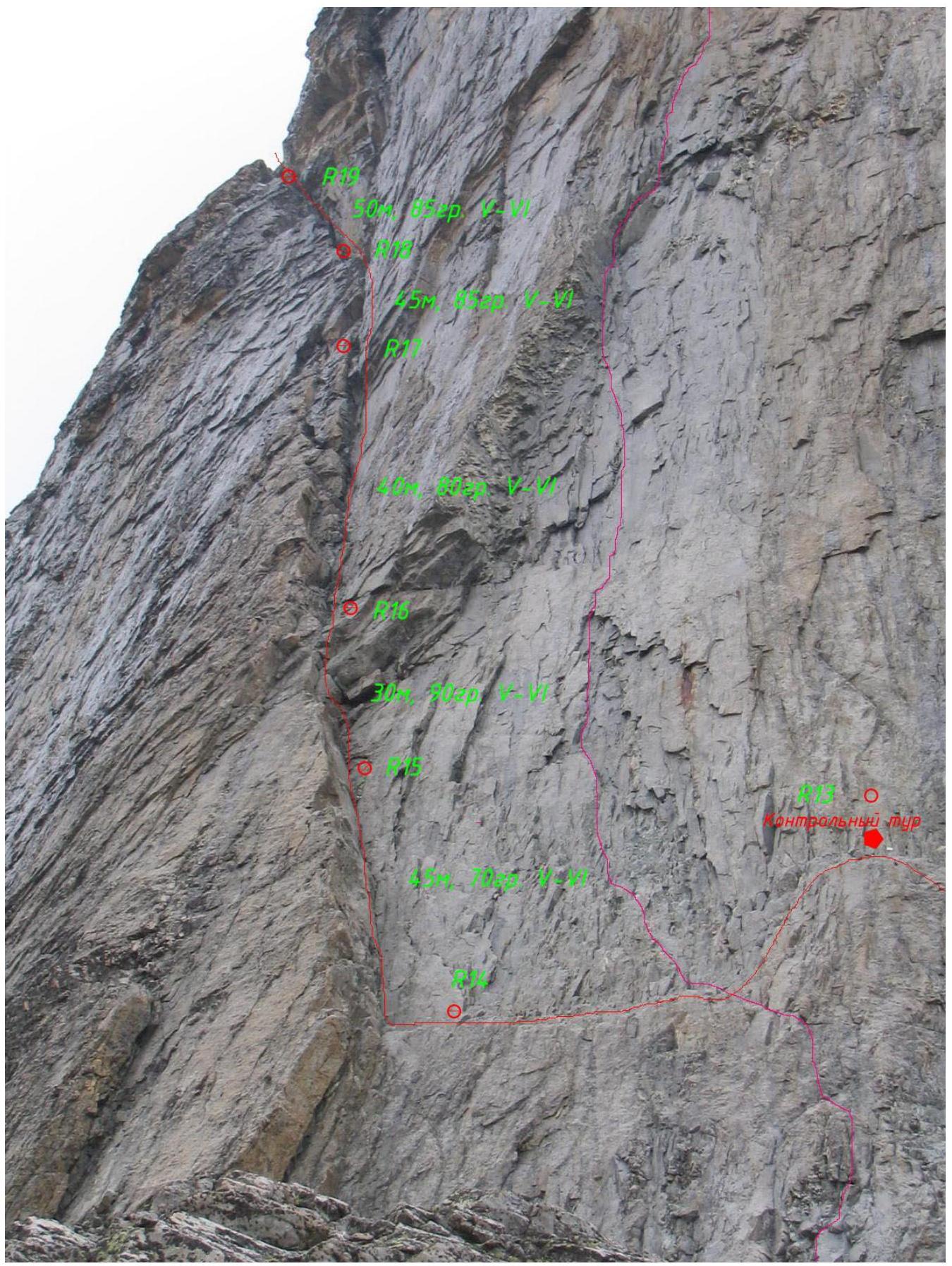
R12–R13: Straight up 7 m of difficult climbing (possibly ITO A1) (5–6 category of complexity), further turning to the left along a steep-angled shelf, approach a horizontal shelf with a control tur and a sign. Station on "native iron". Insurance on anchors and friends. 40 m, 5–6 category of complexity.
R13–R14: Dюльфер 8 m to a horizontal shelf, further on foot along the shelf 20 m, not reaching 10 m to the base of the large internal corner. Station on "native iron". 30 m, 2 category of complexity.
R14–R15: Left and up 10 m to the internal corner, further up along the corner (along the right part, approach under the cornice — not reaching 10 m to it). Climbing along cracks — possibly ice. 5–6 category of complexity, 70°. Insurance on anchors, friends, and placements. 45 m.
R15–R16: Up along the corner to the cornice, the cornice is bypassed on the left. Further, exit to the base of the large chimney (there are live stones). Difficult climbing, possibly ITO A1, 5–6 category of complexity, 90°. 30 m. On this section, there are ropes from previous teams.
R16–R17: Up along the chimney, which gradually expands under the overhanging right part. Station on their points. 80°, 40 m, 5–6 category of complexity. Friends, anchors.
Equipment:
- Friends
- Anchors
R17–R18: Up from the station to the large fork of the chimneys, from the fork to the left up. Climbing is partly along large live blocks. Station above the fork on their points. 85°, 5–6 category of complexity, 45 m. Friends, placements, anchors.
Equipment:
- Friends
- Placements
- Anchors
R18–R19: Up along the chimney through overhangs along the system of cracks, exit to a scree shelf. Further, exit from the shelf through an overhang along its left part to an inclined slab, which leads to the next shelf, in the upper part of which there is a small grotto. Station at the beginning of the shelf to the right on friends and anchors. Climbing is difficult, many wet areas, possibly ice. There is a possibility of dropping stones, which fly strictly on the lower participants along the chimney. The rope goes through bends and is difficult to pull at the end of the section.
- 5–6 category of complexity
- 50 m
- 85°
- Friends, anchors, boxes, placements.
R19–R20: Up along the shelf, further through the grotto (live stones), exit to a chimney — an internal corner along the system of cracks. Further along the corner, in its upper part, exit to the left wall and, traversing above to the right, exit to a flattening — a huge slope. Station on large blocks on the shelf, there is an old hook with an expenditure loop.
- 5–6 category of complexity
- 80°
- 50 m.
R20–R21: Turning to the left, further up along large blocks, partly covered with snow, move along the most logical path. Landmark — the right chimney in the bastion. 4 category of complexity, 40°. Station on a large monolithic block.
R21–R22: Traverse to the right 10 m, further up, turning to the left along "ram's foreheads". 40°, 4 category of complexity, 50 m.
R22–R23: Traverse to the right. Landmark — the ridge of the Pillar against the background of the sky with a clear shelf on it, and old perils are visible, laid through the bivouac. After this shelf, a wall with logical climbing is visible. Few places for insurance, many live stones. To exit to the shelf, you need to climb 10 m up along simple rocks after the traverse. There are areas with ice and snow on the section. The shelf is for one tent, on three sides it is bounded by rock walls. Landmark – hanging perils against the background of the sky further up along the Pillar. Station 5 m above the shelf for the tent — on a small ledge. 4 category of complexity, 50 m. Friends and anchors.
Upper Pillar and to the Summit after 2 Bivouacs
R23–R24: First along a rock slab with cracks, then along an internal corner, resting against a small cornice. The cornice is bypassed on the right. Further along the shelf, turning to the left towards the wall. Further along the wall 25 m. Station on a stone. 5–6 category of complexity, 45 m, 85°.
R24–R25: Up and to the right along the wall under a small cornice (bypassed on the left), further turning to the right along logical relief and focusing on "native perils", we exit to a large shelf with separate large stones. This is the top of the Pillar. Station is native on channels and shлямбуры. 5 category of complexity, 75°, 40 m.
R25–R26: Further, we bypass the bastion on the right along stones and exit to a large scree shelf, along which, pressing against the "Pillar", we approach the base of the ice-snow slope. Station on a stone. 150 m, 2 category of complexity, 30°.
R26–R27: Along the ice slope, traverse to the right into a narrow passage in the "ram's foreheads". Further up along the slope. 45°, 60 m. Station on ice screws.
R27–R28: Further along the slope, turning to the right, through a rock belt (may be filled with snow), we exit to the base of the couloir. 60 m, 45°. Station on ice screws.
R28–R29: Along the couloir, we exit under the base of the upper snow field. Station on a small wall-step (anchors). 50°, 60 m.
R29–R30: From the station to the left up onto the snow-ice field and, sticking to the right boundary of snow and rocks, go up. 45°, 50 m, 4 category of complexity. Station on "ram's foreheads" (anchors and friends).
R30–R31: Further along the slope, we exit onto rocks to the right and along the rocks move along the edge of the ridge. 45 m, 4 category of complexity, 45°. Friends and anchors.
R31–R32: From the station up along the slabs to the wall under the base of the pre-summit bastion, the wall is climbed to the right along a crack. Further along the slabs to an inclined shelf. Station on it – native hooks and expenditure. 4 category of complexity, 40 m. The "rusty corner" remains to the left.
R32–R33: From the station, traversing along a narrow shelf (above and below the shelf is vertical), move to the right, bypassing the pre-summit bastion. After 30 m, the shelf narrows and overhangs from above. You can:
- climb a little lower and exit to the internal corner,
- go higher along a wide crack to the right (for insurance, this is a more preferable option).
After a wedged stone (holds well), to the right another 10 m to the station on a sloping shelf. Under the overhang to the right. The shelf is narrow and sloping — 45°. The walls are vertical. 5 category of complexity. Friends, stoppers, anchors. For the extreme participant, it is necessary to leave points — large pendulums are possible. There are "native" hooks.
R33–R34: Up through the overhang (3 m), further along logical relief up and to the right, striving to bypass the bastion, move in the direction of the couloir with a waterfall. It is better not to exit to the full rope. It is very difficult to shout to the partner; it is advisable to have portable radio communication.
- 5 category of complexity
- 50 m
- 80°
Station opposite the beginning of the waterfall in the couloir, to the left of it.
R34–R35: Up and to the right along simple rocks, we exit to large-block scree on the slope and along it to the right up to the beginning of the pre-summit slope-ridge. 150 m, 2–3 category of complexity.
Movement along the edge of the ridge, which is to the left of us. At the end of the section, there are several places for bivouac. Here it is necessary to visually orient yourself relative to the point of the start of the descent. It is located to the left and behind on the border of the sky and the ridge ("black rock").
To start the descent, you need to:
- Walk 50 m on foot from the possible bivouac sites,
- Cross a small snow couloir from left to right,
- Further descend to a shelf surrounded by walls.
There are expenditure loops on the wall. From here, the descent from the upper bastion begins. The descent is possible in the waterfall, depending on the weather and time of year.
R35–R36: Up from the shelves under the bivouac, movement is simultaneous, along the left side of the large ice couloir to the top of the couloir and along the ridge going to the right, we go to the summit.
In different times of the year, the condition of the pre-summit ridge can be different. There are reports of snow drifts. In our case, the ridge was simple and pedestrian. We walked simultaneously, tied with one rope, without using points. From the start of the section to the summit, it takes 1 hour of leisurely walking. There are rock outcrops of 3 category of complexity. The summit is pronounced, with a control tur among the stones at the top. In bad weather, it is not possible to hide on the ridge. The descent to the start of the dюльферs is along the ascent path.
The descent from the pre-summit bastion was carried out directly along the line of water fall. The landmark is the "black rock" described above. From the pre-summit bastion to the "Pillar", the descent is along the snow-ice slope and further along the ascent path to bivouac №2. From the bivouac, the descent was carried out along Monogarov's route to the central chimney of the "Pillar" and further down along the "Kharakternik" route to the "Georgian Shelf". From the Pillar's top to the chimney on the "Kharakternik" route, old peril ropes are laid. The condition is questionable; it is necessary to duplicate with your ropes and organize insurance for the descending participant. Descent along Myslyaev's route is possible, but the slope from the internal corner of Myslyaev to bivouac №2 is stone-dangerous. From bivouac №1, the descent is along the ascent path.
UIAA Scheme
Section R11–R25 Pillar
 R24–R25: 40 m, 74° IV–V
R23–R24: 45 m, 85° V–VI
R22–R23: 50 m, 50° IV
R21–R22: 50 m, 40° III
R20–R21: 50 m, 40° III
R19–R20: 50 m, 80° V
R18–R19: 50 m, 85° V–VI
R17–R18: 45 m, 85° V–VI
R16–R17: 40 m, 80° V–VI
R15–R16: 30 m, 90° VI A2; cornice, bypass on the left
R14–R15: 45 m, 75° V–IV
R13–R14: dюльфер 8 m, 20 m traverse along the shelf II
R12–R13: 7 m, 90° VI, 30 m, 80° V
R11–R12: 30 m, 45° III, 30 m, 60° IV
R24–R25: 40 m, 74° IV–V
R23–R24: 45 m, 85° V–VI
R22–R23: 50 m, 50° IV
R21–R22: 50 m, 40° III
R20–R21: 50 m, 40° III
R19–R20: 50 m, 80° V
R18–R19: 50 m, 85° V–VI
R17–R18: 45 m, 85° V–VI
R16–R17: 40 m, 80° V–VI
R15–R16: 30 m, 90° VI A2; cornice, bypass on the left
R14–R15: 45 m, 75° V–IV
R13–R14: dюльфер 8 m, 20 m traverse along the shelf II
R12–R13: 7 m, 90° VI, 30 m, 80° V
R11–R12: 30 m, 45° III, 30 m, 60° IV
UIAA Scheme
From the top of the Pillar to the summit R25–R36
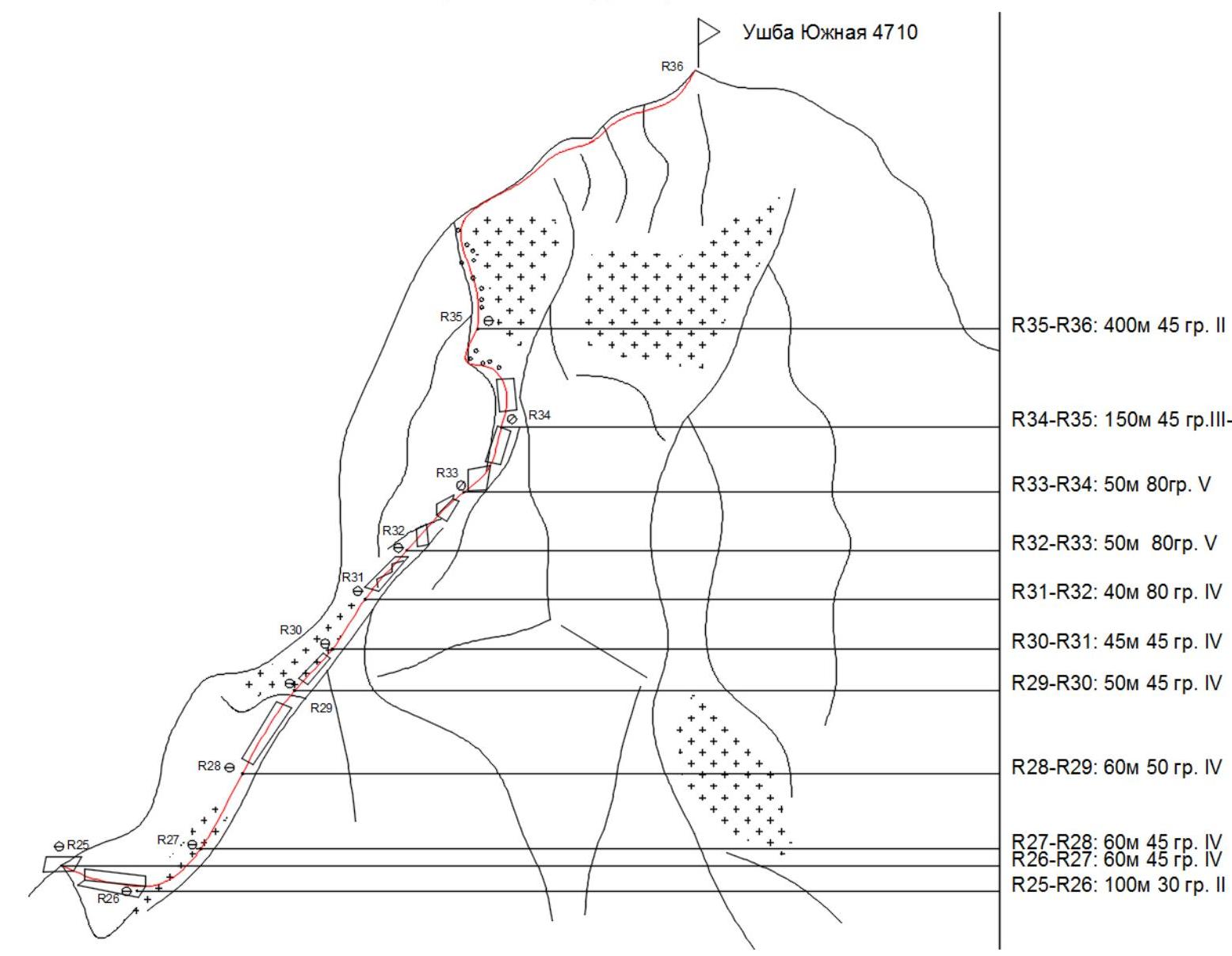 R35–R36: 400 m, 45° II
R34–R35: 150 m, 45° III–I
R33–R34: 50 m, 80° V
R32–R33: 50 m, 80° V
R31–R32: 40 m, 80° IV
R30–R31: 45 m, 45° IV
R29–R30: 50 m, 45° IV
R28–R29: 60 m, 50° IV
R27–R28: 60 m, 45° IV
R26–R27: 60 m, 45° IV
R25–R26: 100 m, 30° II
R35–R36: 400 m, 45° II
R34–R35: 150 m, 45° III–I
R33–R34: 50 m, 80° V
R32–R33: 50 m, 80° V
R31–R32: 40 m, 80° IV
R30–R31: 45 m, 45° IV
R29–R30: 50 m, 45° IV
R28–R29: 60 m, 50° IV
R27–R28: 60 m, 45° IV
R26–R27: 60 m, 45° IV
R25–R26: 100 m, 30° II
Pillar
 Control tur
Photographs from the Sections
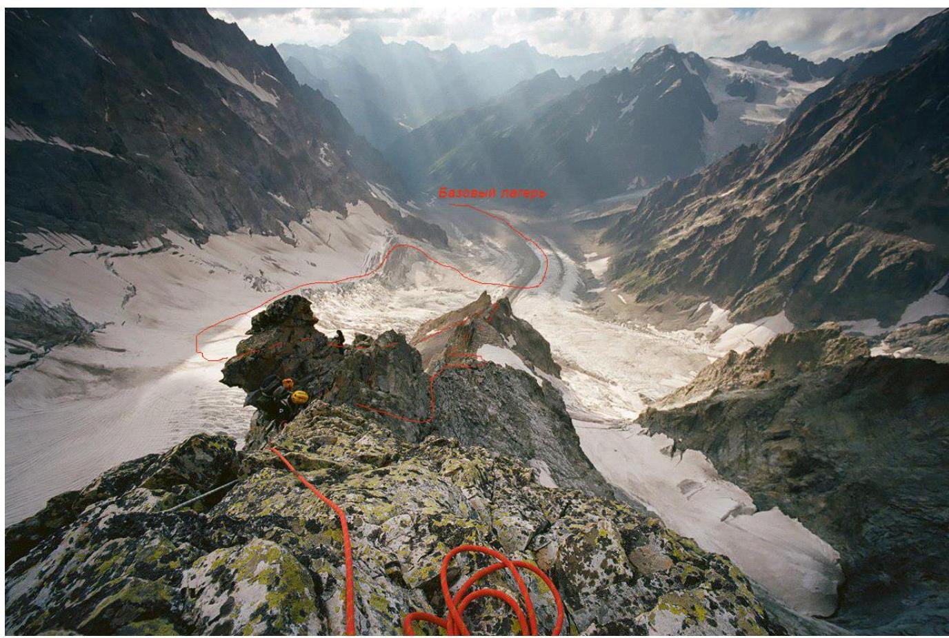 Base camp
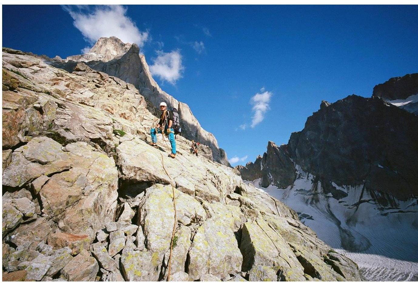 Approach and ridge to the "Georgian" shelf
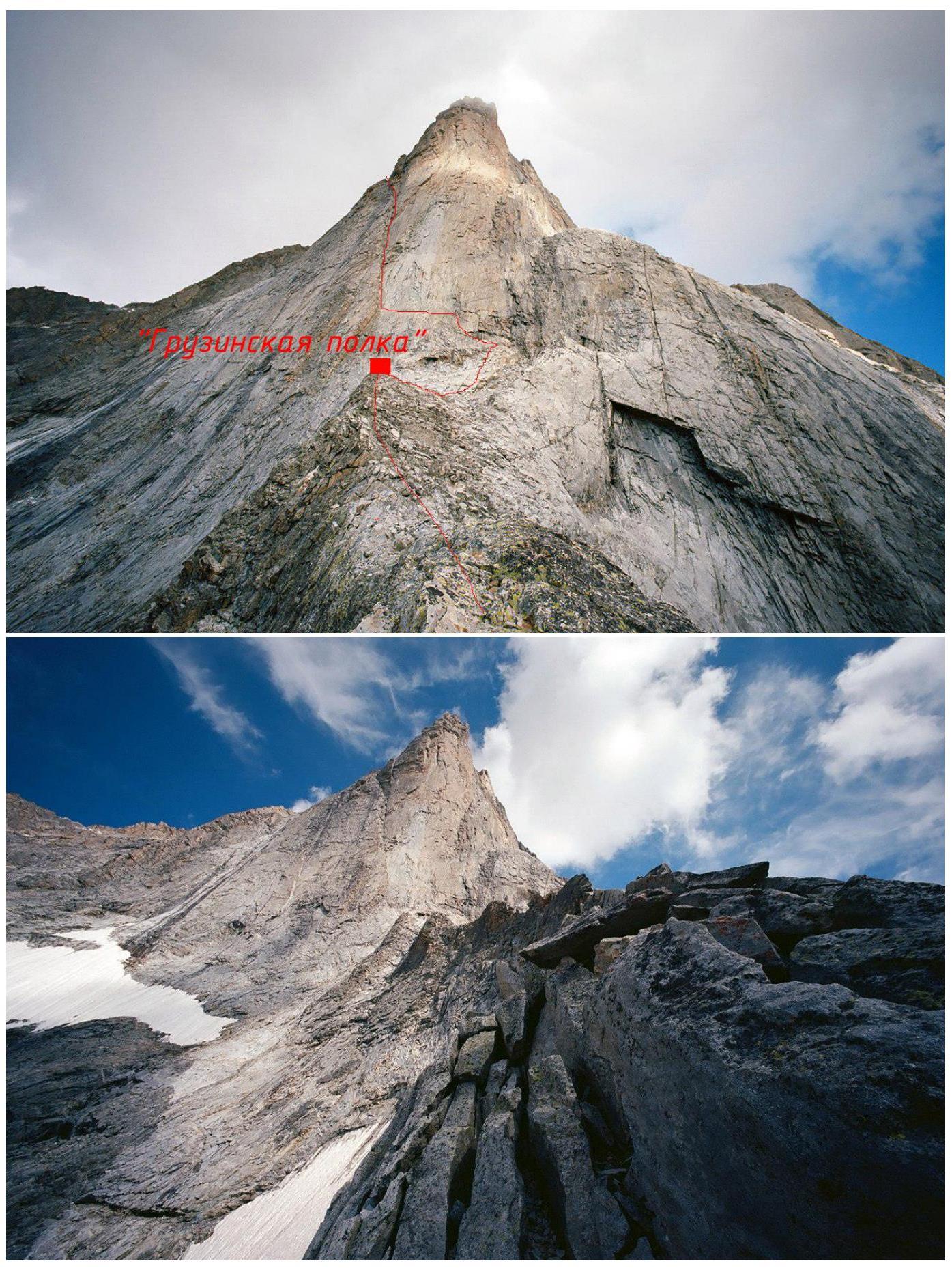
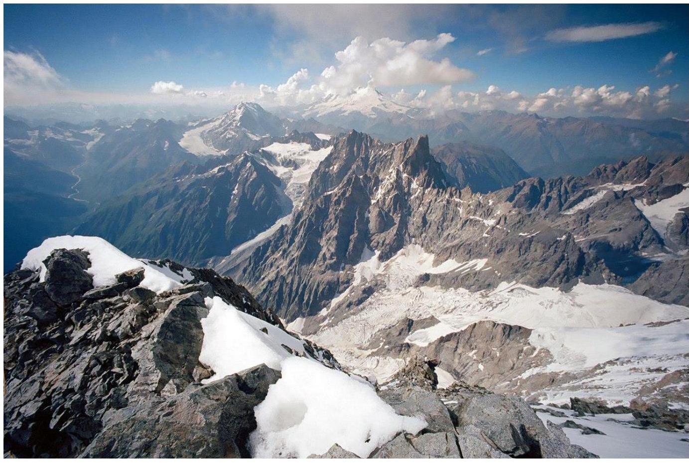
 View of the Pillar and the ridge's top on the approach to the "Georgian" shelf
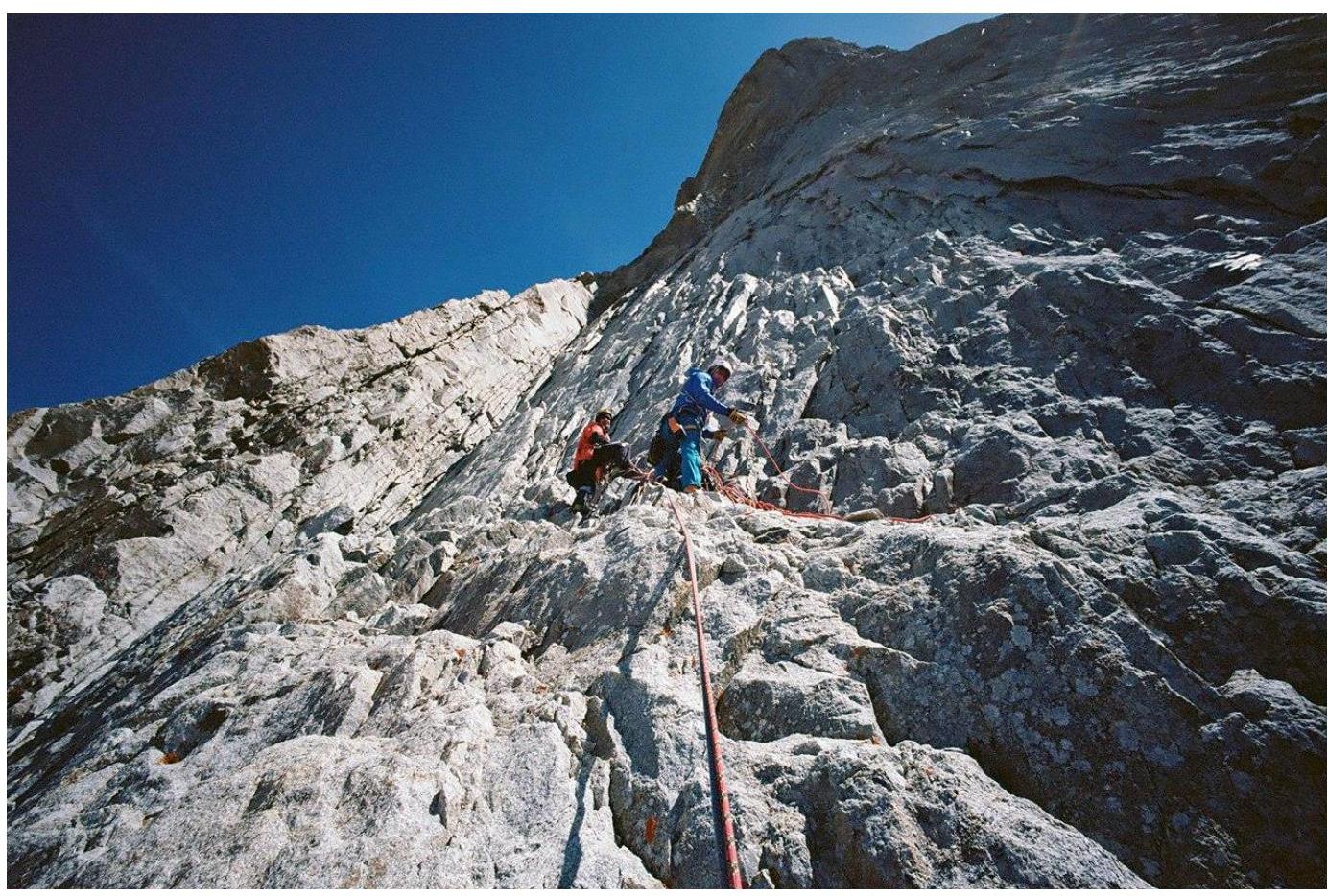
 Internal corner on the Pillar (sections R15–R17)
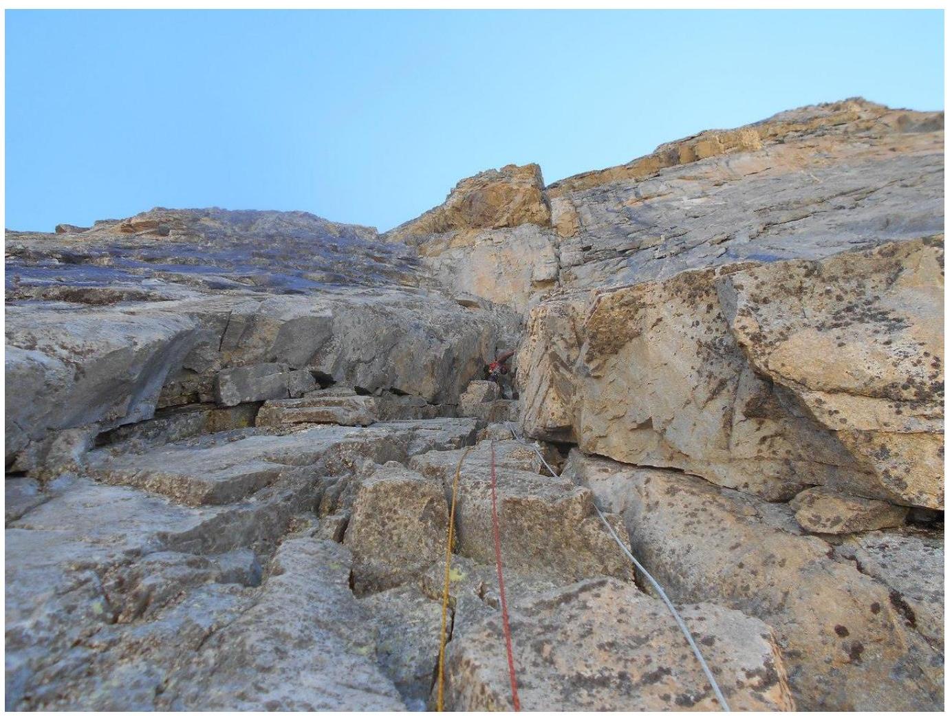
 R18–R19
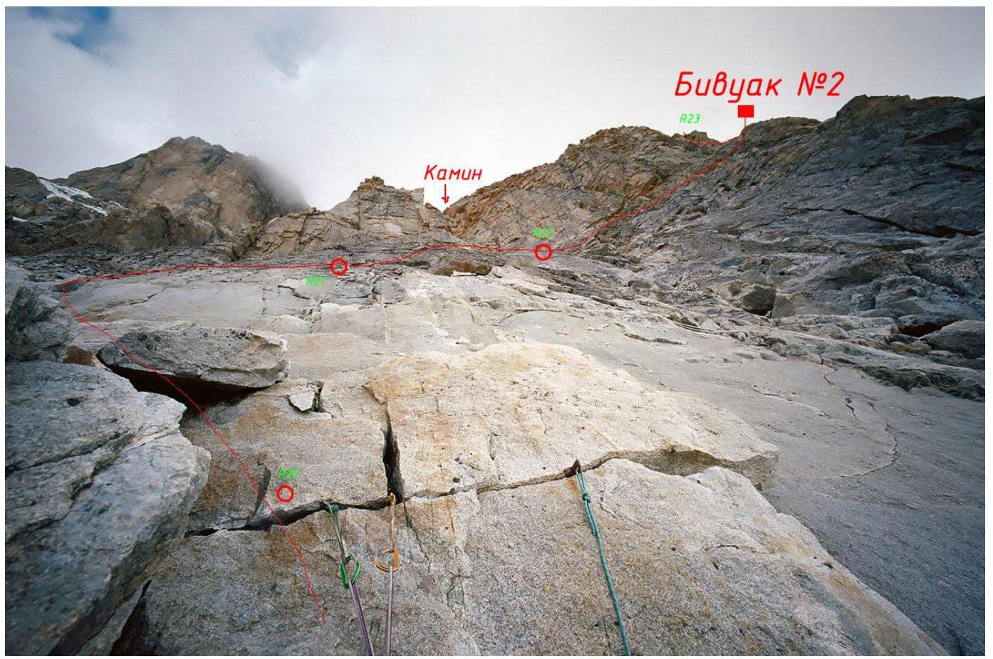
 R20–R23
 Bivouac №2
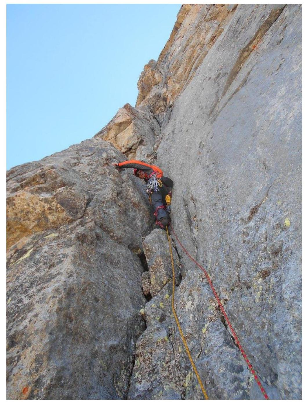
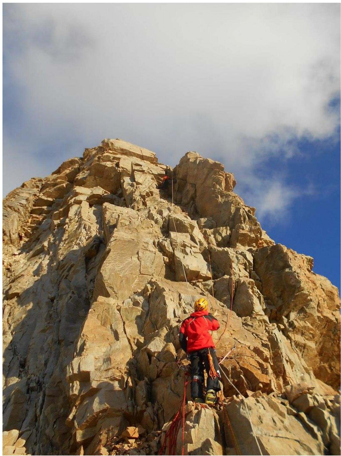
 R23–R24
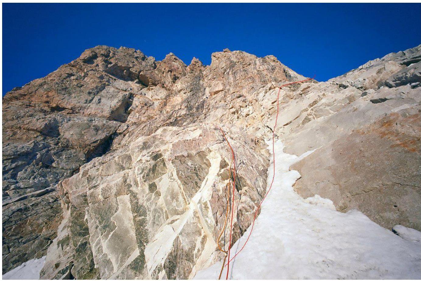
 R33–R34
 On the pre-summit ridge
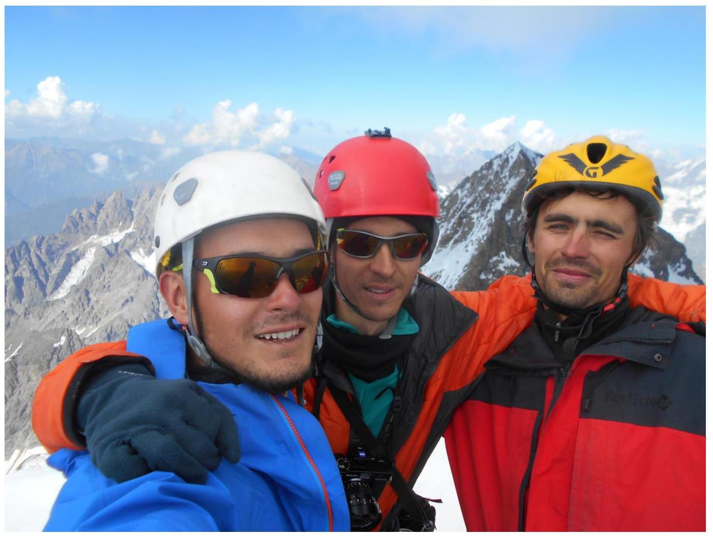
 Summit
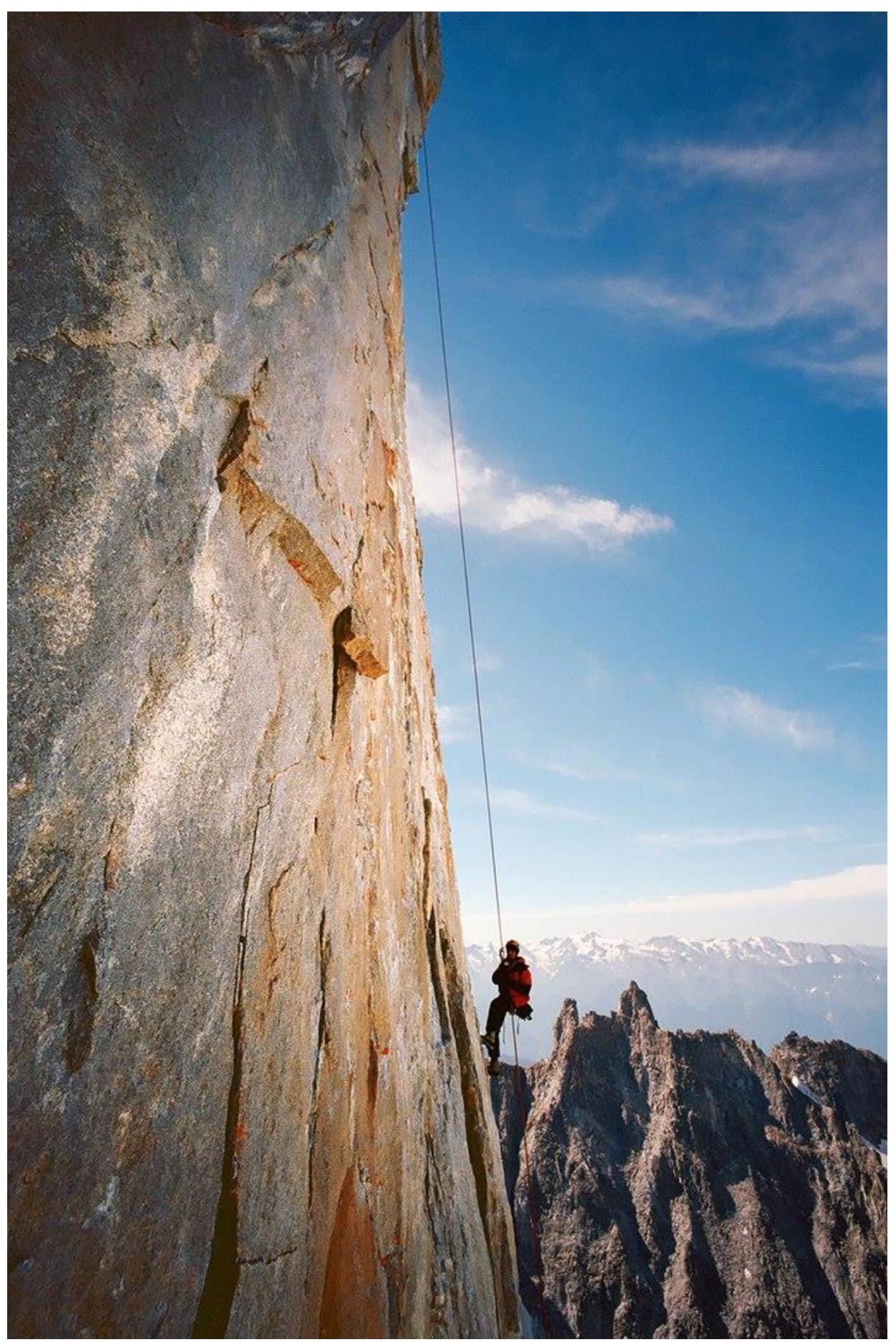
Descent along the centre of the Pillar