Passport
- Climbing category — technical.
- Central Caucasus.
- Ushba South peak (4710) via the left part of the Southwest wall (Myshlyaev's route).
- Proposed 5B category of difficulty, second ascent.
- Route characteristics: height difference — 1460 m (3250 m — 4710 m); length of sections with 5–6 category of difficulty — 810 m; average steepness of main sections —
- Pitons hammered:
- rock: 76
- bolt: 1
- chocks: 95
- ice screws: 20
- Team's working hours: 49.5 hours, 6 days.
- Overnights: 1–2 — comfortable ledge under the SW wall; 3 — sitting on small ledges on the wall under the ice chimney; 4–5 — on the ridge under the pre-summit tower.
- Team:
leader: Yuri Ivanovich Shortov — Candidate Master of Sports
participants:
- Viktor Petrovich Avtomonov — Candidate Master of Sports
- Vladimir Vasilievich Efremov — Candidate Master of Sports
- Alexander Vladimirovich Bezrodny — Candidate Master of Sports
- Ivan Dmitrievich Erohin — Candidate Master of Sports
- Sergey Georgievich Krasnenko — Candidate Master of Sports
- Coach: Yuri Ivanovich Porokhnya — Honored Master of Sports of the USSR.
- Departure to the route — July 3, 1984,
summit — July 8, 1984,
return — July 9, 1984.
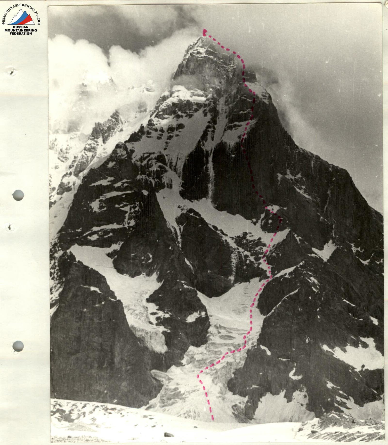
General photo of the summit on July 2, 1984.
- Myshlyaev's route
- Gолубев's route
- Artsishevsky's route
Lens HELIOS 44-2 F=58 mm. Distance to the object R≈2 km. Shooting point #1.
The main initial data for choosing the route was that technically, Ushba is one of the most challenging mountains in the Caucasus, and that this route is diverse in technical terms, both in terms of relief forms and methods of passing various rock sections, and is the most logical and beautiful for ascending Ushba South. That is, it represents a classic route that combines all the best aspects of the Soviet school of mountaineering. Based on this, a tactic was developed that included the use of all technical means to pass various forms of mountain relief, provided that all sections were passed first by free climbing.
The key section of the route was the "oblique crack" with a western orientation, and it was assumed that there would be built-up ice in the crack. The passage of this section was planned after 9:00, and if there was built-up ice, the use of crampons, "fi-fi" and for insurance — bolt pitons.
The safety of the team's movement on the route was ensured by:
- using a double rope both for the first climber's movement and for the rest of the participants, using three jumar clamps;
- belay rope blocking and organization on three anchor points;
- insurance for the first climber through a braking device like "Koshevnik's bug".
Team's Tactical Actions
Day 1
Start of work at 7:00. Movement on sections R0–R3 with simultaneous insurance, on sections R3–R7 along the belay ropes. Arrival at the bivouac at 16:00. Processed two ropes entering the crack.
Day 2
Start of work at 10:00. Processing four ropes along the crack by the trio Avtomonov — Efremov — Bezrodny, first climber's movement on a double rope, insurance through "Koshevnik's bug" braking device. All sections were passed by free climbing. Descent to the overnight stay at 16:00.
Straightened the ropes processed on the first day.
Day 3
Start of work at 7:00. Passing the fixed belay ropes and further processing and exit to the top of the crack, sections R7–R17. Participants' movement on a double rope using three jumar clamps. Exit to the top of the crack at 16:00. Further movement along the snow-ice slope with 40–45° steepness, along single belay ropes, section R17–R18. Arrival under the rock belt at 18:00. Passing section R18–R19. Arrival at the overnight stay at 20:00. Sitting overnight stay. Weather deteriorates at night: snow, fog, strong wind.
Day 4
Start of work at 7:00. Bad weather: snow, strong wind. Section R19–R20. Chimney filled with ice, with a waterfall on top. The first climber passes the chimney in crampons. At 14:00, they stopped for the night on a snowy ridge, not reaching the planned overnight stay under the wall of the pre-summit tower.
Day 5
All night and during the day — very strong wind, snow. Start of work at 11:00. Processed 120 m. Section R20–R22. Climbing is very difficult, very few handholds, the entire wall is wet.
Day 6
Bad weather, strong wind. Start of work at 8:00. Passed the processed section. At 11:00, they started processing the wall of the summit tower, section R23–R26. The first climber works in galoshes. Difficult climbing. At 14:00, they reached the snowy ascent to the summit. At 15:00, they reached the summit. At 15:30, they started descending.
Thus, the route was completed in 6 days and one day for descent. The tactical plan had envisaged completing the route in 7 days, taking into account two days of bad weather.
During the passage of the route:
- There were no falls or injuries.
- The team's movement on difficult sections was on a double rope.
- Communication with observers was carried out regularly.
- There was also voice communication with interaction groups in the upper part of the route.
The team's work in bad weather conditions was reliable.
Route Assessment by Sections
Section R0–R1. 300 m, 30°. The beginning of the route is on the right side of the glacier falling from under the Southwest wall. In the middle part, the glacier is broken, with crevices and 2–3 m high ice walls. Movement with variable insurance through ice screws.
Difficulties on the section:
- Glacier breakage in the middle part
- Presence of crevices
- Ice walls 2–3 m high
- Movement with variable insurance
Section R1–R2. After the broken middle part, the glacier becomes gentler, but then becomes even steeper, up to 40°. Movement with alternate insurance through an ice axe stuck in the snow.
Section R2–R3. 200 m, 40°. Exit to the upper part of the glacier. Insurance through an ice axe.
Section R3–R4. 80 m, 45°. Along the border of the glacier and rocks, exit to a wide sloping snow ledge under the Southwest wall. Insurance through rock pitons and chocks.
Section R4–R5. 120 m, 40°. Straight up, we exit under the wall.
Section R5–R6. 40 m, 70°. Wall of block type. Exit to the ridge.
Section R6–R7. 50 m, 30°. Along the ridge, we exit to a platform under the Southwest wall "pillar". Overnight stays.
Section R7–R8. 40 m, 30°. Steep sloping snow-ice ledge. Insurance through ice screws.
Section R8–R9. 50 m, 80°. Wall in front of the start of the "crack". Difficult climbing in galoshes.
Section R9–R10. 45 m, 70°. "Crack" — a giant internal corner. Insurance through chocks and thin petal pitons. Climbing is difficult, with a transition from one side of the corner to the other.
Section R10–R11. 50 m, 80–95°. Along the left side of the corner, along the wall, in the upper part — an overhang. Difficult climbing.
Section R11–R12. 50 m, 90°. In the center of the corner — a chimney, overcome in a camming position.
Section R12–R13. 45 m, 85–95°. The chimney narrows to 30–40 cm. The position of the belayer's body is in a camming position in the crack.
Section R13–R14. 50 m, 90°. Transition to the left side of the corner and along its outer part — difficult climbing along the wall. Very small handholds.
Section R14–R15. 45 m, 80°. We enter the corner and along the crack, exit to the upper part of the corner.
Section R15–R16. Exit to the upper part of the Southwest wall. "Sheep's foreheads". Insurance through large chocks.
Section R16–R17. 150 m, 40°. Wide snow-ice belt with rock outcrops like "sheep's foreheads". Insurance through ice screws or bolt pitons.
Section R17–R18. 60 m, 70°. Rock couloir filled with snow and ice. Difficult climbing; in the upper part — small ledges in the ice. Sitting overnight stay.
Section R18–R19. 90 m, 80°. Chimney filled with ice, with water flows. The first climber works in 12-tooth crampons. In the upper part, the chimney turns into a corner and leads to a snowy saddle. Overnight stay.
Section R19–R20. 40 m, 80°. Wall filled with water. Working in galoshes is impossible. Very difficult climbing.
Section R20–R21. In the upper part of the wall, an overhang. A cornice cuts through a crack, with the help of which the overhang is passed. Insurance through large chocks.
Section R21–R22. Gentle snowy section 90 m, 30°.
Section R22–R23. 40 m, 70°. The wall leads to a sloping ledge. Along the ledge to the right 20 m.
Section R23–R24. 30 m, 80°. Severely destroyed corner. In the upper part — an overhang.
Section R24–R25. 50 m, 70°. Through the overhang to the right and then along a narrow crack, we exit into a rock couloir.
Section R25–R26. 40 m, 60°. Up the couloir, exit to the "roof".
Section R26–R27. 200 m, 30°. Along a wide snowy couloir, exit to the ridge leading to the summit. Exit to the summit.
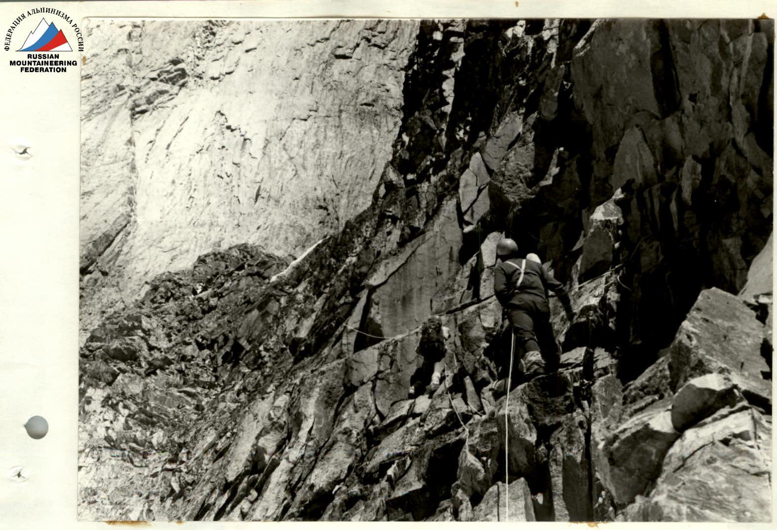
PHOTO 3. July 3, 1984. Section R7
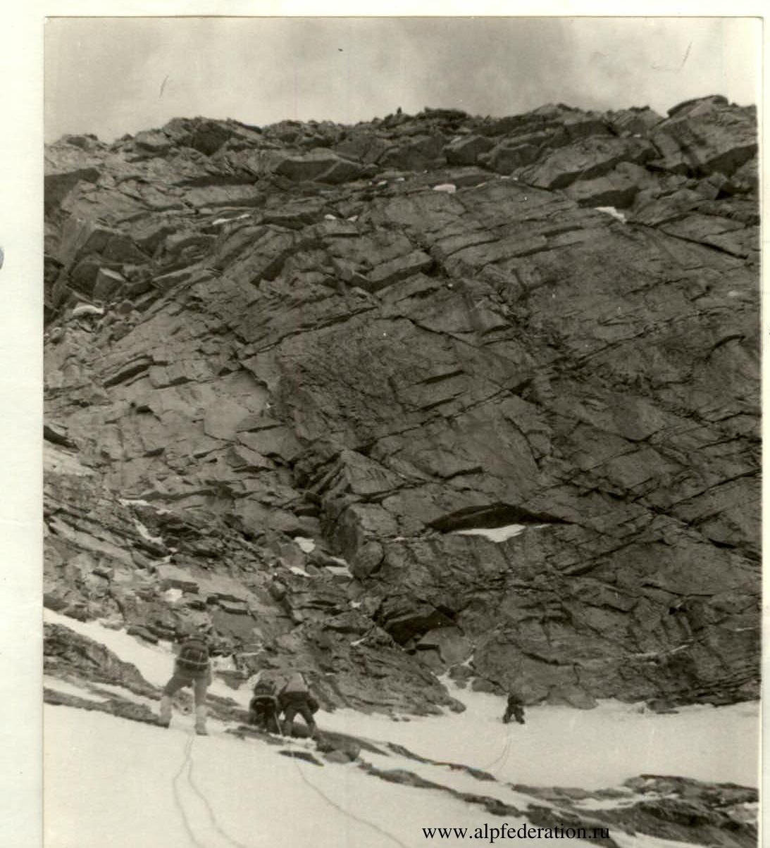
PHOTO 4. 5.07. Section 10. Wall before the start of the "crack".
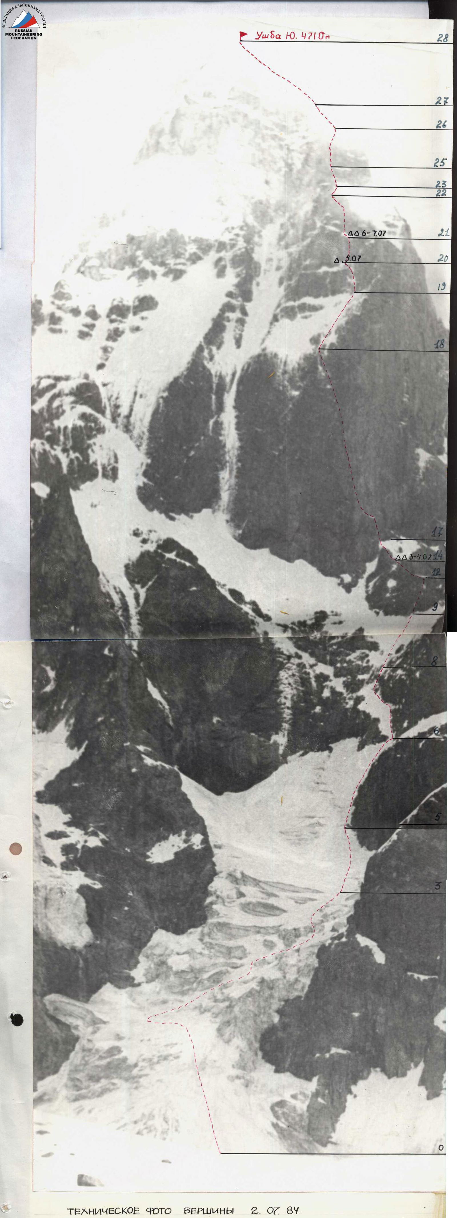
TECHNICAL PHOTO OF THE SUMMIT on July 2, 1984. Lens "HELIOS 44-2". Distance to the object R≈2 km. Point #1.

PHOTO 5
- July 5, 1984
- Section R12
- Lower part of the crack
