
PASSPORT
- Class — ice and snow
- Central Caucasus, Ushbinsky spur of the Main Caucasian Range.
- Ushba South peak (4710 m) via the icefalls of the Northwest, Northwestern wall.
- Proposed — 6B category of difficulty, first ascent.
- Elevation difference: 2210 m, length 3630 m, length including traverses — 3800 m. Length of sections 5–6 — 2300 m. Average steepness of main sections 40° (2500 m – 4710 m). Of these, 6 — 140 m (90°, 3030–3130); (90°, 3565–3605 m).
- Number of pitons driven — 233:
| Rock | Bolts | Chocks | Ice screws |
|---|---|---|---|
| 39/0 | 0/0 | 4/0 | 190/0 |
-
Team's travel hours: 26 h 30 min and days — 3.
-
Overnights: 1st — on an ice ledge carved in the bergschrund; 2nd — on a snow-ice ledge carved in the ridge.
-
Leader — FOROSTYAN Vitaly Yuryevich — MS;
Deputy leader — PALAMARCHUK Valery Nikolayevich — MS; Participants:
- KULICHENKO Anatoly Petrovich — CMS;
- LEBEDEV Gennady Igorevich — CMS;
- LIKHACHEV Valery Grigoryevich — CMS;
- RYBALKA Konstantin Pavlovich — CMS.
-
Team coach — CHEREVKO Vladimir Leonidovich — MS.
-
Departure to the route — August 9, 1982.
Summit — August 11, 1982. Return — August 12, 1982.
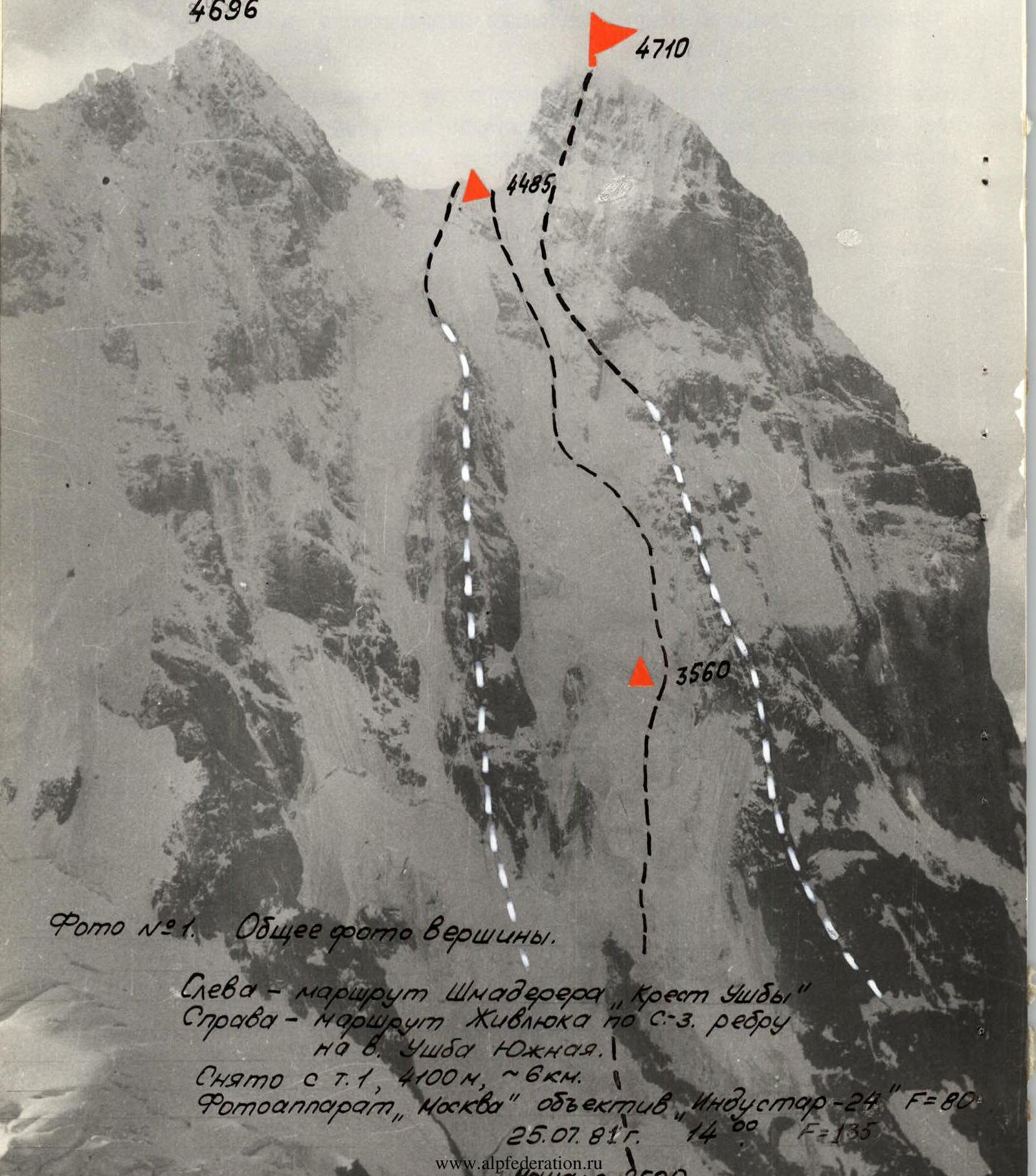
Photo #1. General photo of the summit. Left — Shmadereer route, "Ushba Cross". Right — Zhyvlyuk route via NW ridge to Ushba South summit. Taken from point 1, 4100 m, ~6 km. Camera "Moscow", lens "Industar-24" F=80. July 25, 1981, 14:00.
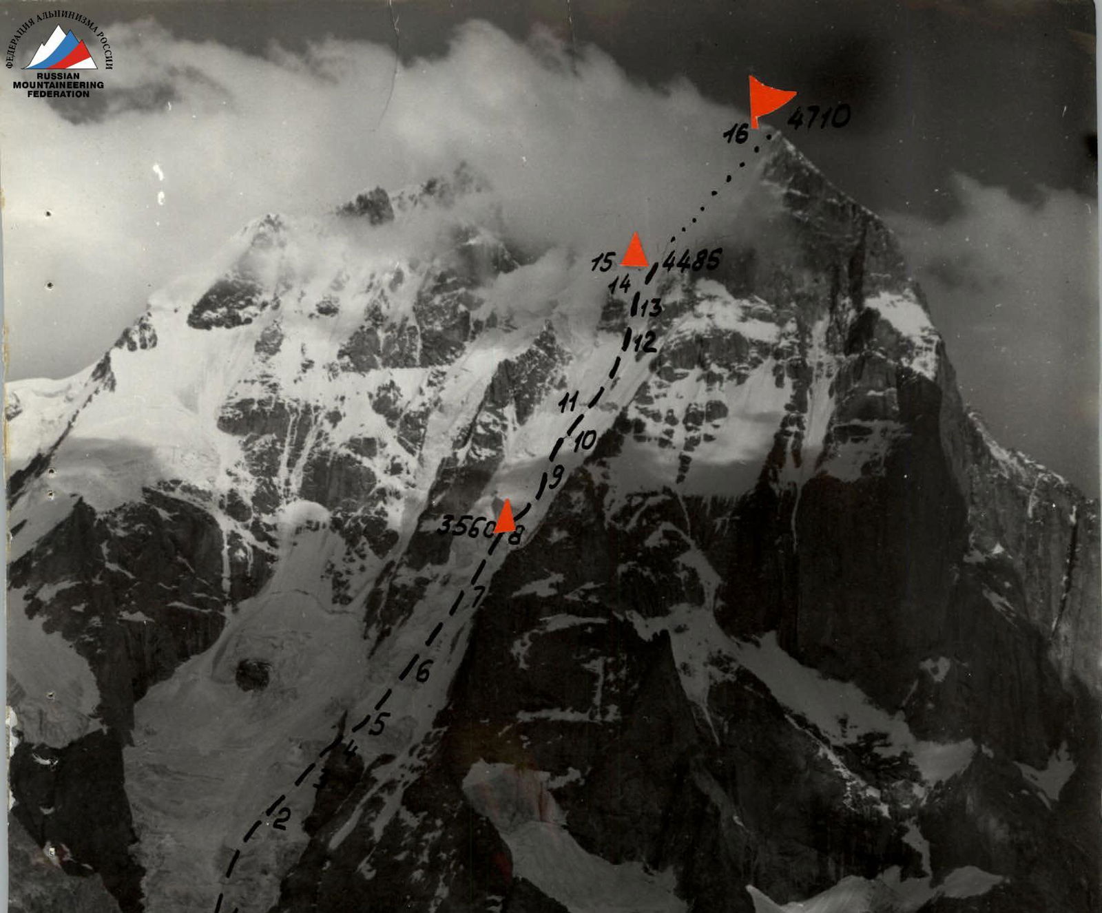
Photo #2. Photo of the wall profile from the right. Taken from point 4, 3200 m, ~4 km. Camera "Moscow", lens "Industar-24" F=135. July 27, 1982, 17:00.
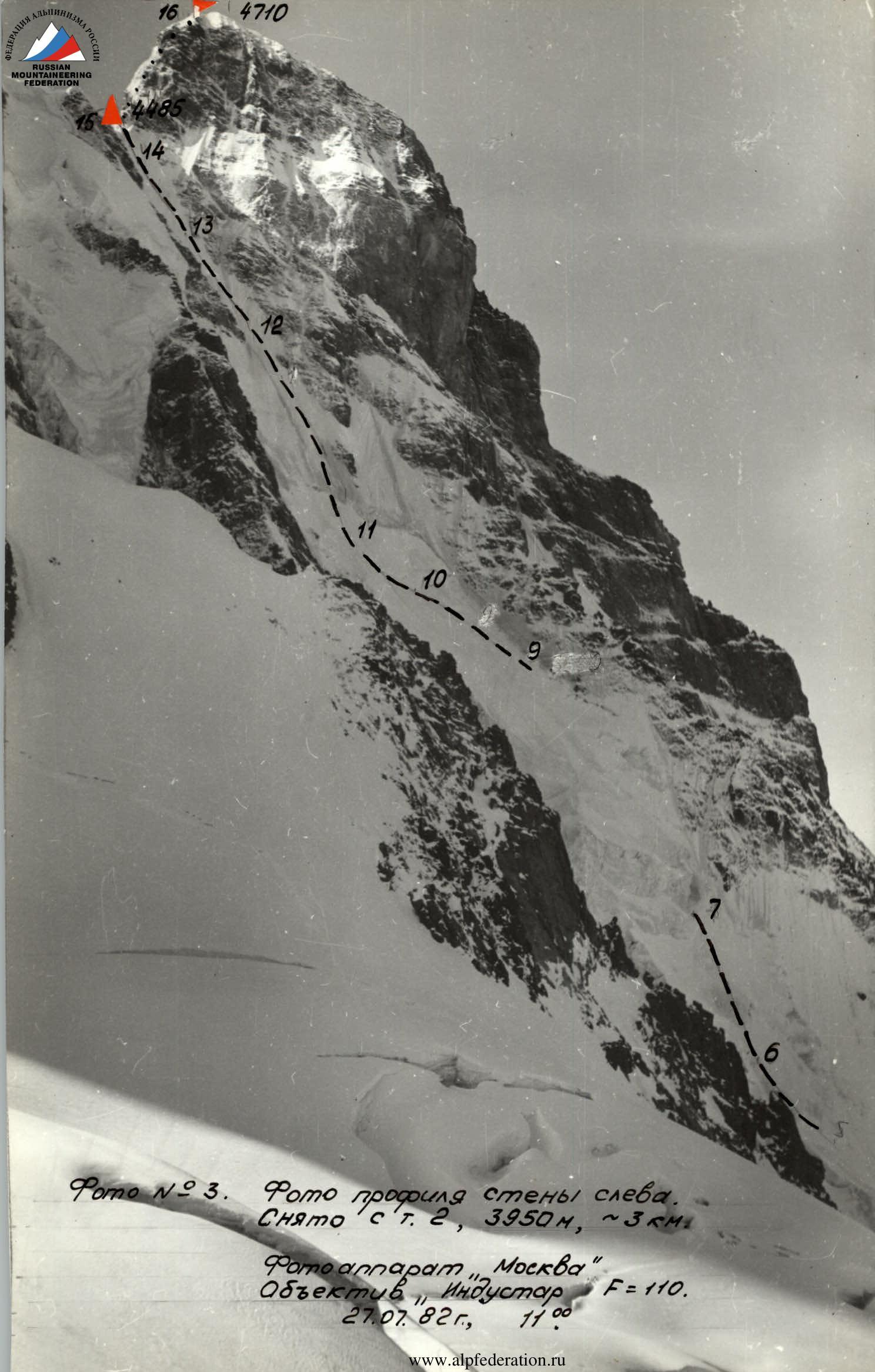
Photo #3. Photo of the wall profile from the left. Taken from point 2, 3950 m, ~3 km. Camera "Moscow", lens "Industar-24" F=110. July 27, 1982, 11:00.
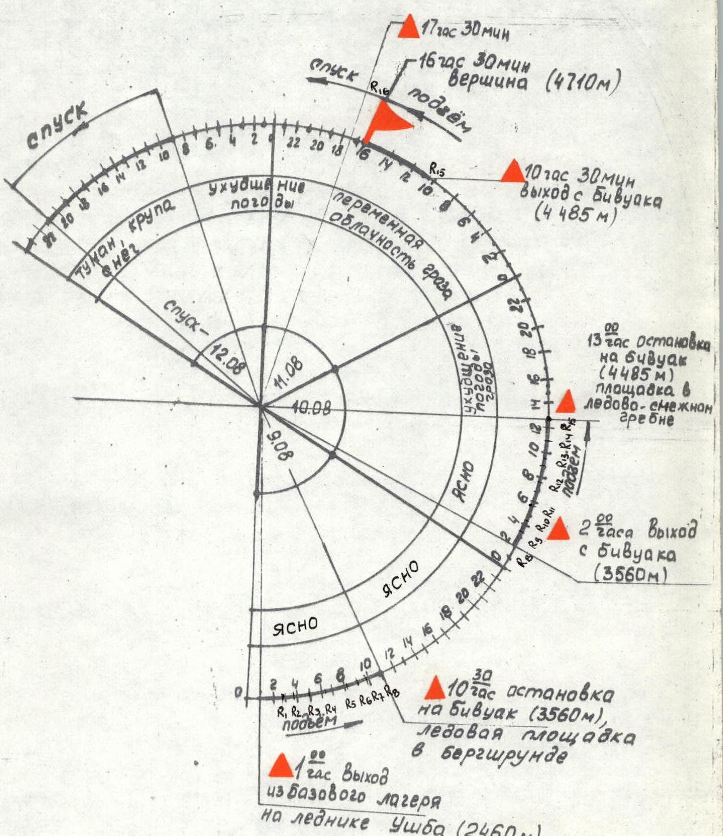
Ascent graph. Descent — August 12. Ascent. 17:30. 16:30. Summit (4710 m). 10:30. Departure from bivouac (4485 m). Fog, sleet, snow. Weather deterioration. Variable cloudiness, thunderstorm. Clear. August 11, August 10, August 9. 13:00. Stop at bivouac (4485 m), ledge on ice-snow ridge. 2:00. Departure from bivouac (3560 m). 10:00. Stop at bivouac (3560 m), ice ledge in bergschrund. 1:00. Departure from base camp on Ushba glacier (2460 m).
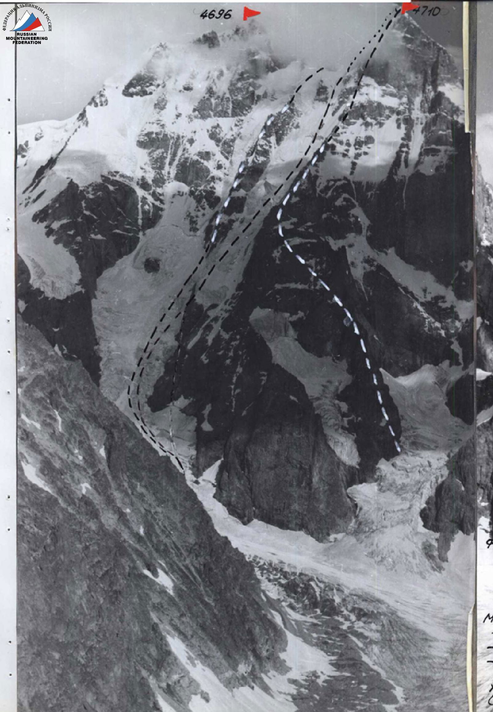
Photo #4. Photopanorama of the area. Taken from point 4, 3200 m, ~4 km. Lens "Industar-24" F=135. July 27, 1982, 17:00. Left — peak Ushba (4710 m). Routes (left to right): — Shmadereer "Ushba Cross" — route taken by the team via icefalls — Zhyvlyuk route X — Mazerovsky pass Right — peak Mazera (3900 m).
After studying, scouting, and observing the object, the team chose a tactic to ascend the route during night and early morning hours, as this is the safest time regarding avalanches and ice falls (see movement graph). The departure date was also related to safety — in early August, snow masses typically melt from the routes, and ice is exposed; nights are cold, contributing to ice freezing. Additionally, August 9 is a full moon, providing good visibility at night.
The movement path was chosen to ensure cover by relief features where possible (see photos 1, 5 — general and technical photos of the route).
Bivouacs were planned in the middle part of the route:
- in ice fractures under the cover of a rock counterfort (section R7–R10),
- further under the cover of a large triangular rock island (point R12),
- and on the ridge between the North and South summits (point R15).
Considering the challenging weather conditions in the Central Caucasus in the summer of 1982, the team planned to ascend the route with three overnight stays at the indicated points and three reserve days for bad weather. However, thanks to relatively good weather and movement tactics using independent teams with hook usage by the first team, they managed to complete the route ahead of schedule, i.e., with two overnight stays instead of three, omitting the uncomfortable sitting overnight stay at point R12. On the most challenging sections (R4–R5 and R8–R9), interaction between teams was organized, with the first and last climbers ascending without artificial aids, i.e., on "ice-fy-fy". Interaction between teams was also used on certain sections of R15–R16, as the rocks were difficult to pass due to snow and ice.
Thus, the team's ascent coincided with the planned tactical plan (see appendices — route sheet with tactical plan, ascent analysis protocol).
Preliminary processing of route sections was not used. To ensure safety during the ascent to the summit, backup groups from the Central Sports Council and the Ukrainian Republican Council of the "Spartak" Sports Society ascended via the routes of Zhyvlyuk and Grigorenko-Prigoda.
Groups maintained radio contact and had observers. There were no accidents or injuries.
The ascent was completed in full accordance with the tactical plan.
Route diagram in UIAA symbols. Scale 1:2000.
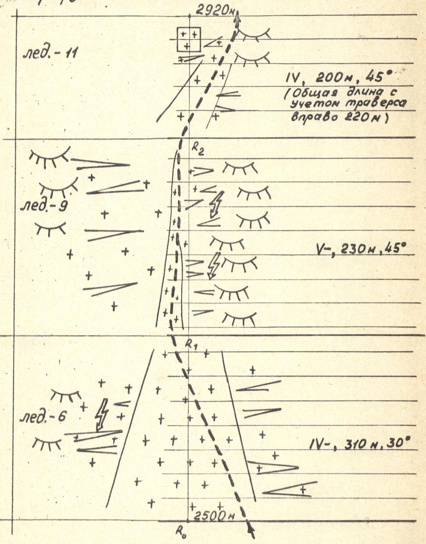
Ice — 11. IV, 200 m, 45° (Total length including traverse to the right 220 m). Ice — 9. V, 230 m, 45°. Ice — 6. IV, 310 m, 30°. R0, R1, R2. 2500 m.
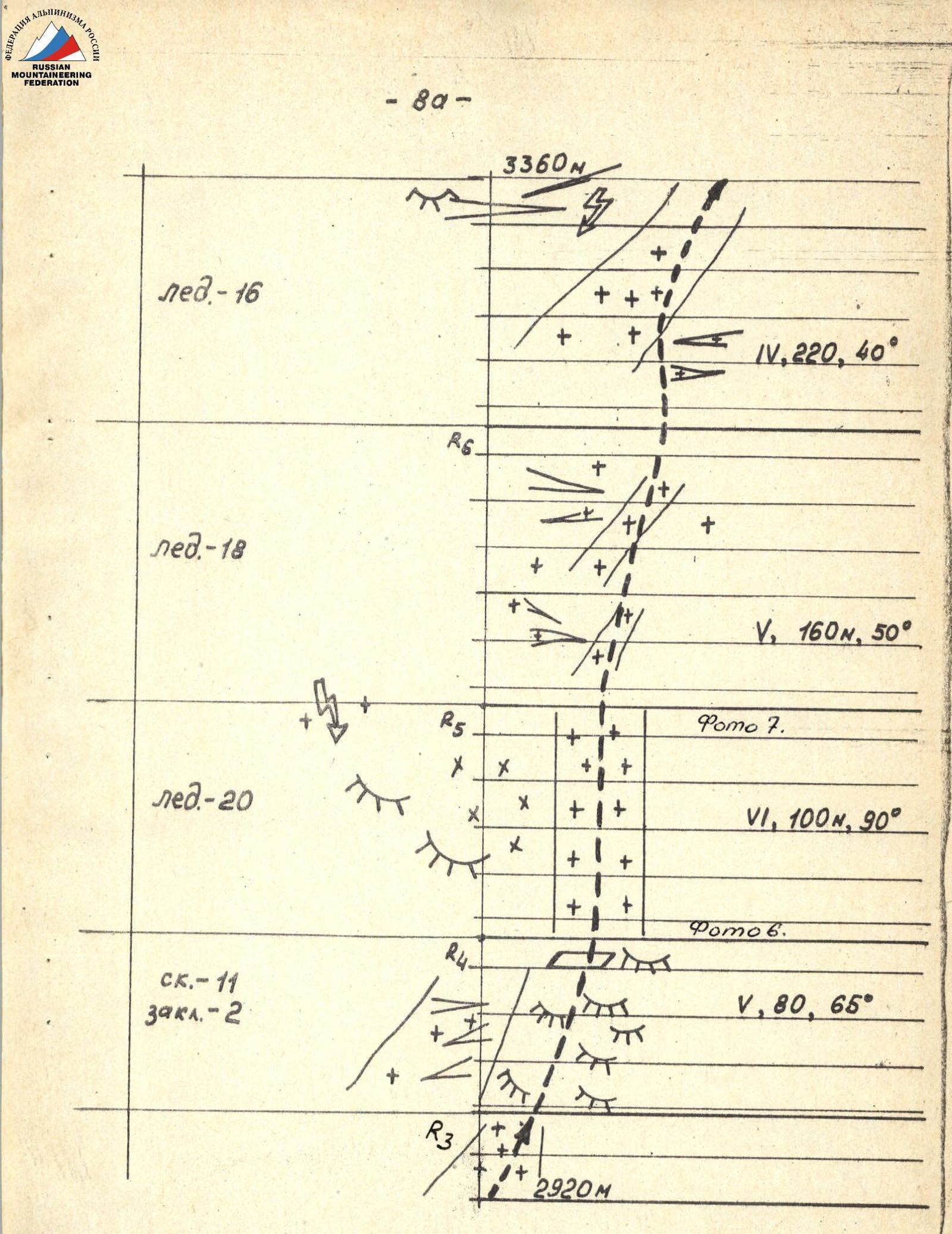
Continuation of the route diagram. Ice — 16. 3360 m. IV, 220 m, 40°. R6. Ice — 18. V, 160 m, 50°. R5. Ice — 20. VI, 100 m, 90°. Rock — 11, Chocks — 2. R4. V, 80 m, 65°. R3. 2920 m.
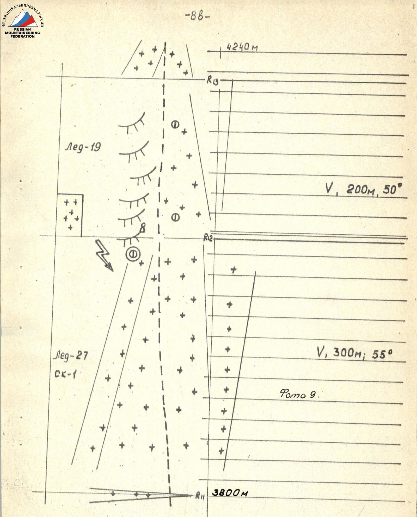
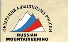
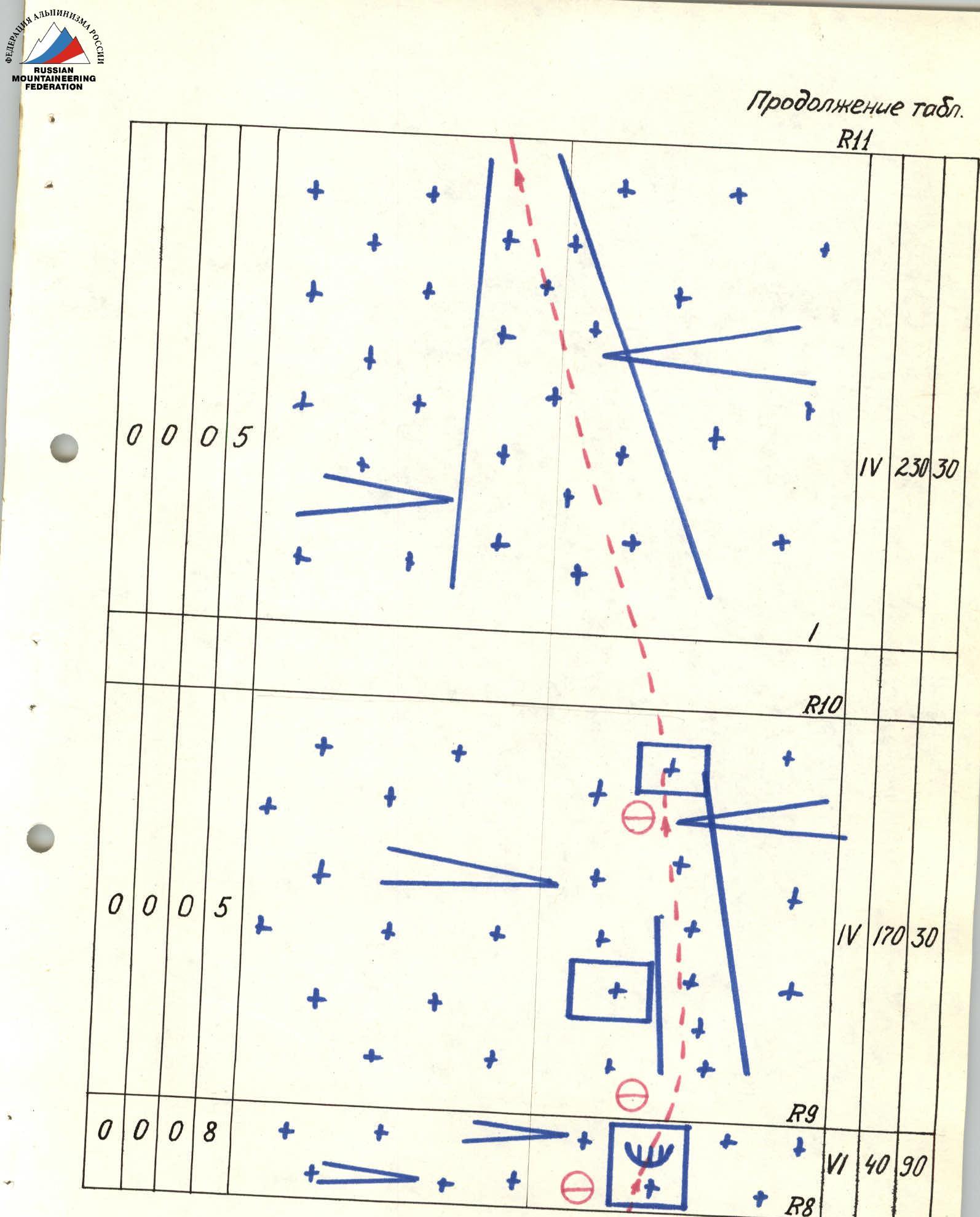
Continuation of the route diagram. R13. 4240 m. Ice — 19. V, 200 m, 50°. R12. Ice — 27. Rock — 1. V, 300 m; 55°. R11. 3800 m.
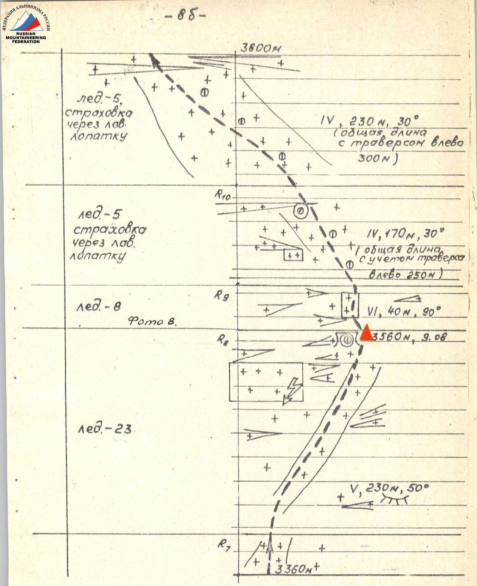
Continuation of the route diagram. 3800 m. Ice — 5, belay via avalanche shovel. IV, 230 m, 30° (total length with traverse to the left 300 m). R10. Ice — 5, belay via avalanche shovel. IV, 170 m, 30° (total length including traverse to the left 250 m). R9. Ice — 8. VI, 40 m, 90°. 3560 m, August 9. R8. Ice — 23. V, 230 m, 50°. R7. 3360 m+.
Description of the Route by Sections
The route begins from the avalanche cone flowing from the icefall of the Northwest wall of Ushba and passes through the right part of the cone, then along the ice slope (R0–R1) towards a narrow ice gully in the lower part of the icefall. The gully (about 200 m, R1–R2) is bounded on both sides by steep ice fractures. The path goes along the right part of the gully on the boundary of the fractures. Move quickly, at night.
Then, up and to the right along a steep ice-snow slope, bypassing the ice wall, towards a rock belt supporting the first step of the icefall (R2–R3). The rock belt is passed in a narrow place (about 80 m, along "ram's foreheads"), with careful piton belay (R3–R4). Approach a narrow ledge under the ice wall of the first step. The wall is climbed directly (100 m, 90°, R4–R5).
Depending on the state of the ice in the season (the icefall moves and changes structure from season to season), other options for passing the first step may appear.
Then, up and to the right along ice ridges with crevasses (R5–R6), which lead to a large ice-snow slab (R6–R7). Along the slab, up and to the right towards the right edge of the second step of the icefall. The wall of the second step is bypassed along ice fractures on the right (R7–R8). The path logically leads to a wide bergschrund extending up and to the right from the wall of the second step of the icefall. In the bergschrund is a convenient and safe place for a bivouac.
From the base camp on the glacier under the route — about 10 hours.
From the bergschrund, exit via an ice wall (40 m, R8–R9) onto steep ice-snow slopes cut by two long bergschrunds crossing the slope (R9–R11). The bergschrunds were crossed via snow bridges at night.
Beyond the upper bergschrund — a path along smooth, steep ice, slightly covered with snow, towards the right lower edge of a triangular rock island and under its cover (R11–R12).
At point R12, on the edge of the island — a control cairn (a can on a rock edge, visible from afar, protected from possible avalanches by upper rocks of the island). Under the island on the ice, a sitting bivouac can be organized (R12). From the previous bivouac — 6–7 hours.
The triangular island is bypassed on the right, closer to the rocks, along smooth ice. Avalanches can go on the right along the "neck"!
Then, along the ice slope up and slightly to the right towards the next rock island (R13–R14). The island is also bypassed along the ice, and then — exit to the ridge (R14–R15). On the ridge — a place for a bivouac. Cornices! From point R12 — 5–6 hours.
The summit tower (about 240 m, R15–R16) is climbed along the general path. It represents a system of walls and narrow ledges, with short internal corners. Average steepness — about 70°. The rocks are icy, snowy, with loose stones. Careful piton belay.
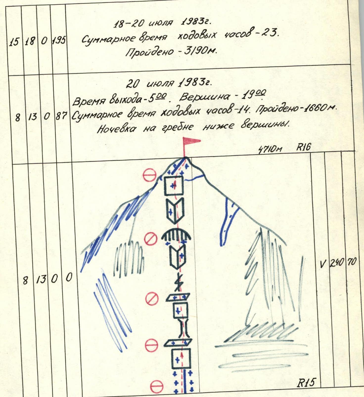
The tower ends with a snow dome. Exit to the summit from the rocks along a short snow ridge. Descent — along the general path via "Krasny Ugol".
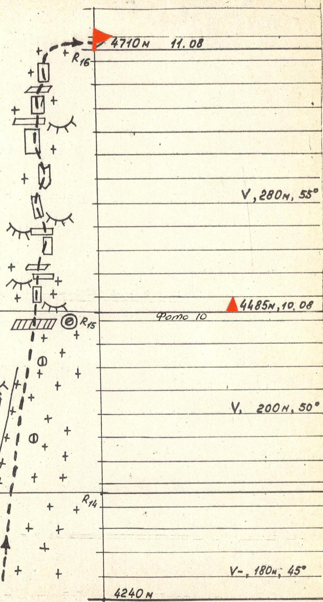
Photo #7. Passage of section R4–R5 (3100 m). End. Taken from below from a distance of ~10 m. Camera "Lubitel", lens T-22, F=75. August 9, 1982, 14:40.
Photo #5. Technical photo of the route. Taken from point 3, 2700 m, 1.5 km. Camera "Moscow", lens "Industar-24" F=135. July 27, 1982, 15:00.
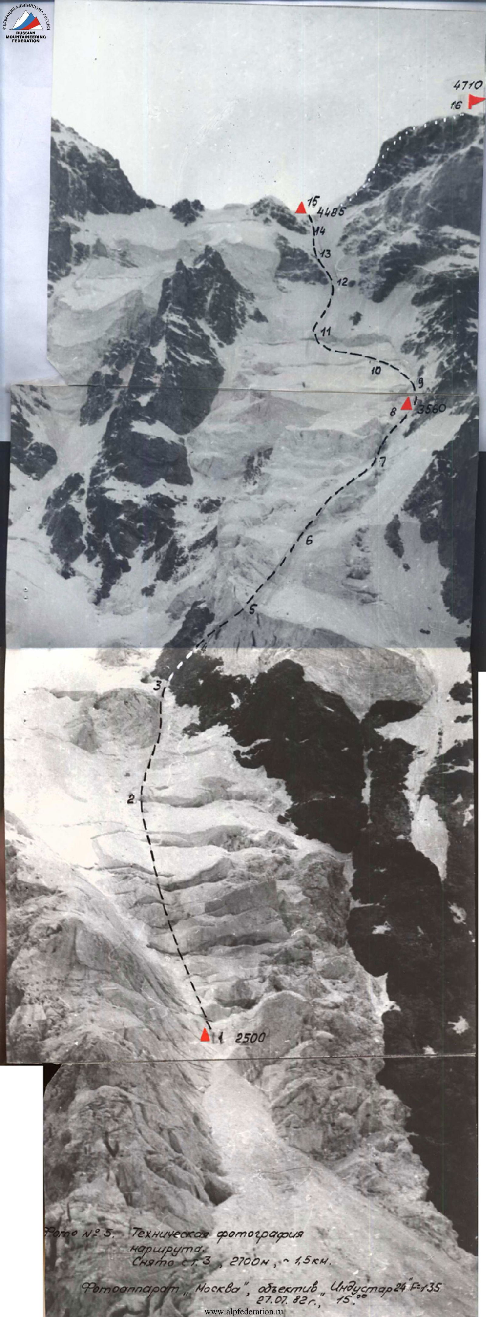
Photo #6. Passage of the beginning of section R4–R5 by the last participant. Taken from the side, right of point 5. Camera "Lubitel", lens T-22, F=75. August 9, 1982, 14:10.
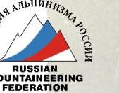
Photo #10. Section R14–R15. Exit to the ridge, cornices visible. Taken from ridge point R15 (4485 m). Camera "Lubitel", lens T-22, F=75. July 10, 1982, 14:30.
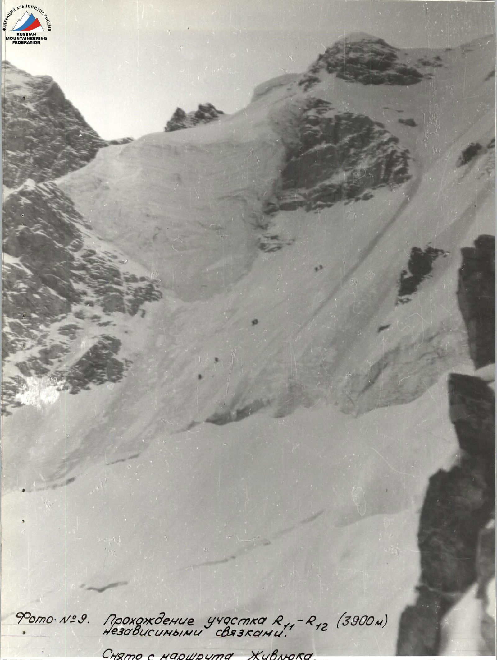
Photo #9. Passage of section R11–R12 (3900 m) by independent teams. Taken from Zhyvlyuk's route. Camera "Moscow", lens "Industar-24" F=135. August 10, 1982, 14:00.
Photo 1. Ushba summit. Taken from slopes of peak Shkhielda (4250 m), point 1. July 24, 1983, 10:00. Distance — ~4.5 km. Camera "Moscow", "Industar-24", F=105 mm.
- Shmadereer route via NW wall, 5B category of difficulty.
- Team's route via icefalls of NW wall, 1983.
- Zhyvlyuk route via NW ridge, 5B category of difficulty.
PASSPORT
- Class — technical.
- Central Caucasus, Ushbinsky spur of the Main Caucasian Range.
- Ushba South peak via icefalls of the Northwest wall.
- 5B category of difficulty, second ascent.
- Elevation difference: 2210 m, length — 3190 m, length including traverses — 3550 m.
- Average steepness of the main part of the route 49° (2500–4710), of which 6 — 140 m — 90° (3030–3130; 3565–3605).
- Number of pitons driven:
| Rock | Bolts | Chocks | Ice screws |
|---|---|---|---|
| 15 + 3 | 0 | 18 | 195 |
| 0 | 0 | 0 | 0 |
* — Reuse of previously driven pitons.
8. Team's travel hours: 23 h and days — 3. 9. Overnights: 1st-2nd — ice-snow ledge carved in bergschrund for 5 people. 10. Leader: Klikushin Gennady Stepanovich, CMS.
Participants:

-   Stalmakhov Alexander Vasilyevich, CMS;
-   Kalyugin Konstantin Viktorovich, CMS;
-   Zhuravlev Viktor Vasilyevich, CMS;
-   Maneev Nail Ismailovich, CMS.
11. Coach: Koreneva Irina Yefimovna, MS USSR. 12. Departure to the route: July 18, 1983.
Summit: July 20, 1983.
Return: July 22, 1983.
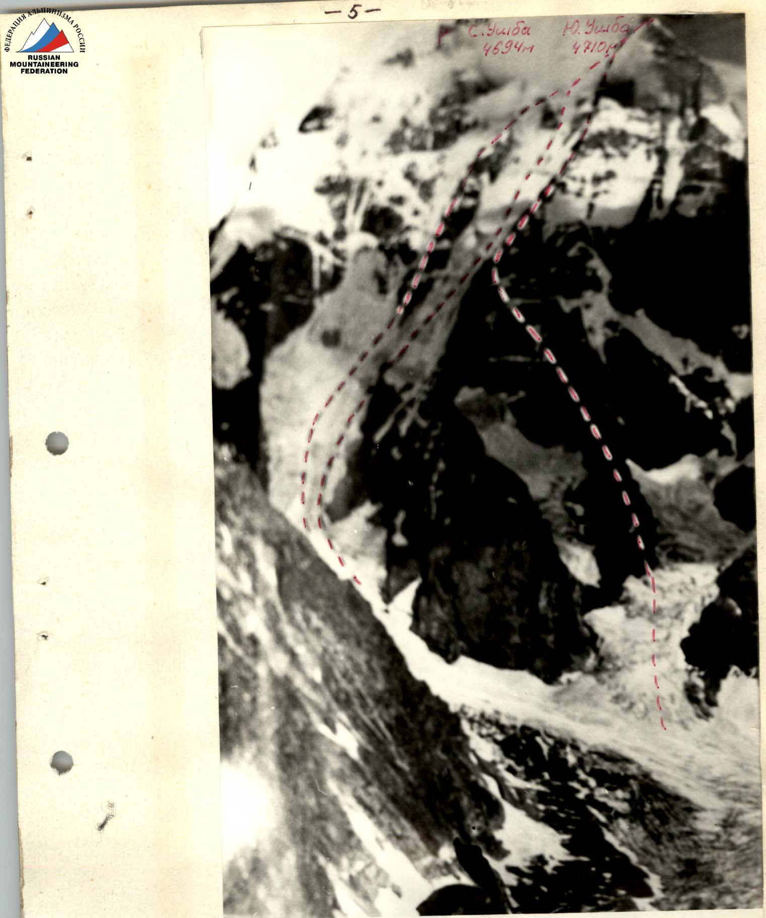
Photo 4. Photopanorama of the area. Taken from slopes of peak Shkhielda (3700 m). July 7, 1983, 17:00. Distance — ~4 km. Lens — "Industar-24", F=135 mm.
| Difficulty | Length (m) | Steepness (°) |
|---|---|---|
| Pitons | ||
| Rock Bolt | Chock Ice screw | |
| R2 | ||
| V | 230 | 45 |
| R1 | ||
| IV | 310 | 30 |
| 2500м | R0 |
July 19, 1983. Did not ascend due to bad weather. Avalanches!!!
Continuation of the table.
| Rock | Bolt | Chock | Ice screw |
|---|---|---|---|
| 7 | 5 | 0 | 108 |
July 18, 1983. Departure time — 5:00. Stop at bivouac time — 12:00. Total travel time — 9 hours. Distance covered — 1530 m. Overnight conditions — good. Strong snowfall by morning. — 3560 m R8
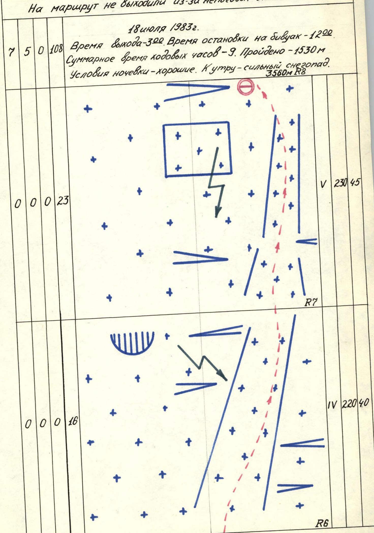
Continuation of the table.
| Rock | Bolt | Chock | Ice screw |
|---|---|---|---|
| 0 | 0 | 0 | 23 |
V, 230 m, 45° R7
| Rock | Bolt | Chock | Ice screw |
|---|---|---|---|
| 0 | 0 | 0 | 16 |
IV, 220 m, 40° R6
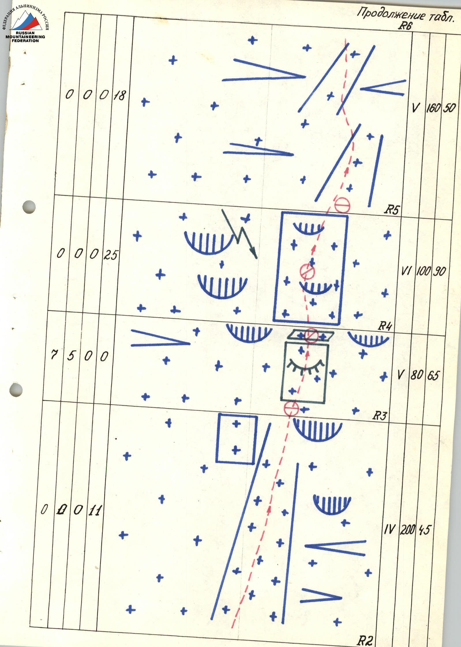
Continuation of the table.
| Rock | Bolt | Chock | Ice screw |
|---|---|---|---|
| 0 | 0 | 0 | 18 |
V, 160 m, 50° R5
| Rock | Bolt | Chock | Ice screw |
|---|---|---|---|
| 0 | 0 | 0 | 25 |
VI, 100 m, 90° R4
| Rock | Bolt | Chock | Ice screw |
|---|---|---|---|
| 7 | 5 | 0 | 0 |
V, 80 m, 65° R3
| Rock | Bolt | Chock | Ice screw |
|---|---|---|---|
| 0 | 0 | 1 | 1 |
IV, 200 m, 45° R2
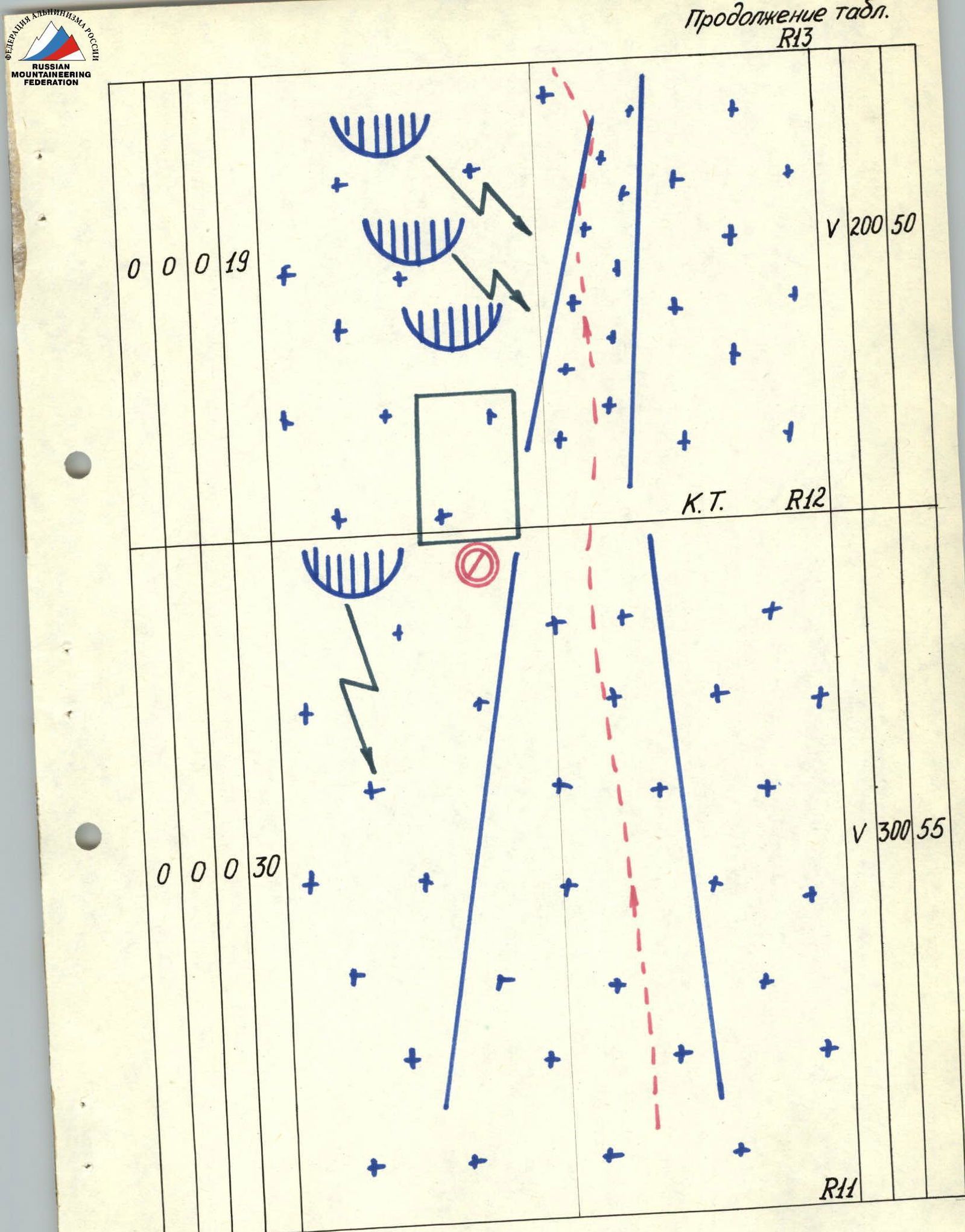
Continuation of the table.
| Rock | Bolt | Chock | Ice screw |
|---|---|---|---|
| 0 | 0 | 0 | 19 |
V, 200 m, 50° C.T. R12
| Rock | Bolt | Chock | Ice screw |
|---|---|---|---|
| 0 | 0 | 0 | 30 |
V, 300 m, 55° R11
Continuation of the table.
| Rock | Bolt | Chock | Ice screw |
|---|---|---|---|
| 0 | 0 | 0 | 5 |
IV, 230 m, 30° R10
| Rock | Bolt | Chock | Ice screw |
|---|---|---|---|
| 0 | 0 | 0 | 5 |
IV, 170 m, 30° R9
| Rock | Bolt | Chock | Ice screw |
|---|---|---|---|
| 8 | 0 | 0 | 0 |
VI, 40 m, 90° R8
Continuation of the table.
| Rock | Bolt | Chock | Ice screw |
|---|---|---|---|
| 15 | 18 | 0 | 195 |
July 18-20, 1983. Total travel time — 23 hours. Distance covered — 3190 m. July 20, 1983. Departure time — 5:00. Summit — 19:00.
| Rock | Bolt | Chock | Ice screw |
|---|---|---|---|
| 8 | 13 | 0 | 87 |
Total travel time — 14 hours. Distance covered — 1660 m. Overnight on the ridge below the summit. 4710 m R16
| Rock | Bolt | Chock | Ice screw |
|---|---|---|---|
| 8 | 13 | 0 | 0 |
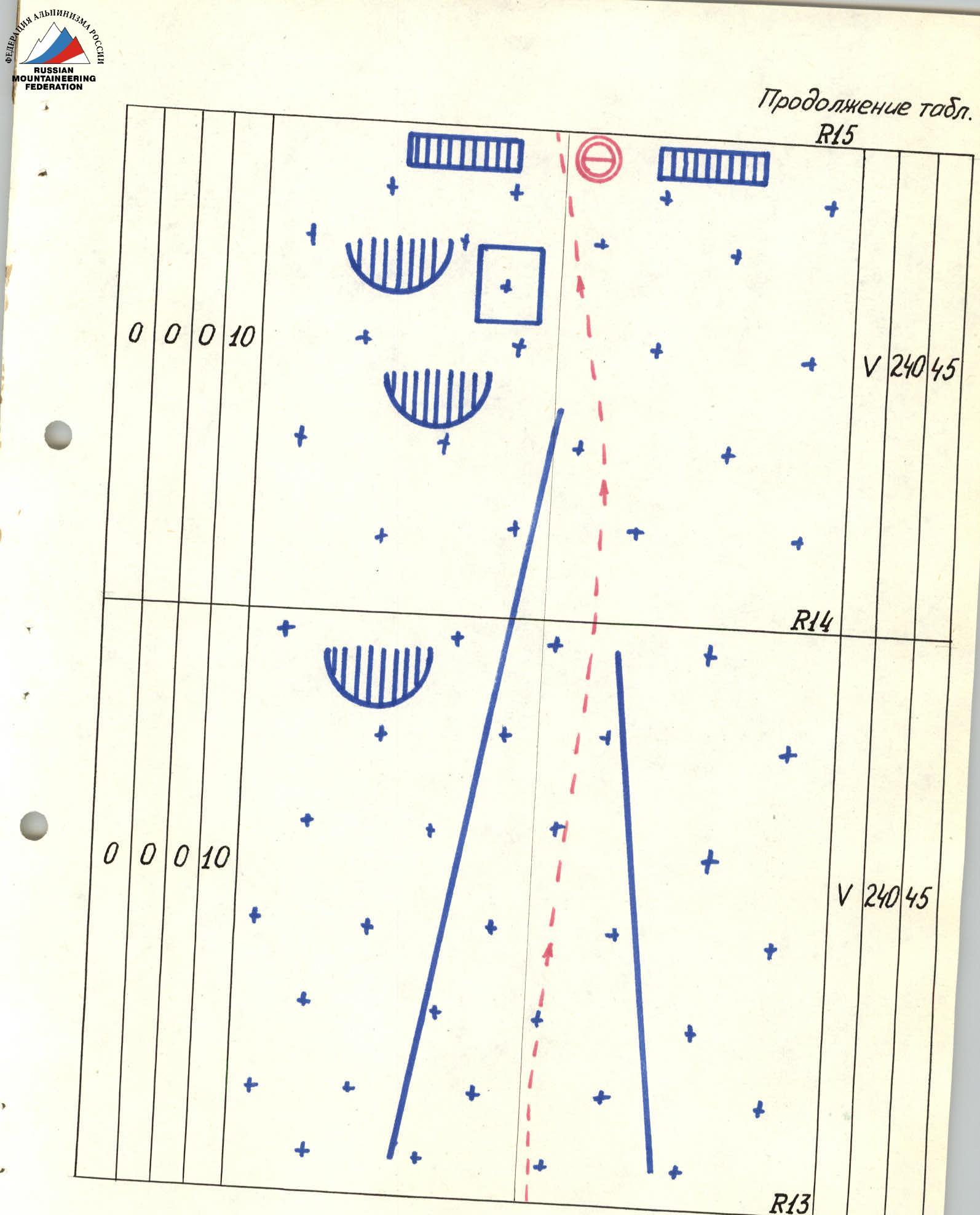
V, 240 m, 70° R15
Continuation of the table.
| Rock | Bolt | Chock | Ice screw |
|---|---|---|---|
| 0 | 0 | 0 | 10 |
V, 240 m, 45° R14
| Rock | Bolt | Chock | Ice screw |
|---|---|---|---|
| 0 | 0 | 0 | 10 |
V, 240 m, 45° R13
From the bergschrund, exit via an ice wall (R8–R9) (passed by independent teams) onto a snow-ice slope cut by two long bergschrunds (R9–R11). The first bergschrund was crossed via a snow bridge, and the second had to be overcome via an ice wall (10 m). Beyond the upper bergschrund — a path along smooth, steep ice towards the right lower edge of a triangular rock island and under its cover (R11–R12). At point R12, on the edge of the island — a control cairn. Replaced the note of the first ascenders. A can visible from afar (an example of a well-placed control cairn). A safe sitting overnight stay was possible, but work was required on the ledge. Time — 7:00, continued movement. The triangular island is bypassed on the right, closer to the rocks, along smooth ice. Avalanches go on the right along the "neck" during the day! Then, along the ice slope up towards the next rock island (R13–R14), which is also bypassed on the right. From the second rock island along the ice — exit to the ridge (R14–R15). Cornices!!! Reached the ridge at 11:50.
After radio contact, continued movement along the ridge to the summit (R15–R16). The ridge represents a system of walls, ledges, internal corners, and chimneys. All rocks are icy, ledges are heavily snowed. Required the use of all advanced rock climbing techniques. The entire ridge was climbed by the first climber without artificial aids. Perils were organized on certain sections. The first climber reached the snow dome ending the summit tower at 17:50.
However, due to a thunderstorm, it was necessary to secure the rope and descend 50 m down. After waiting an hour, at 18:00, everyone was on the summit, replaced the note, and immediately began descending towards peak Mazeri. At 21:00, organized a ledge on the ridge in deep snow and set up for an overnight stay.
The next day, after morning radio contact at 8:00, continued descent via "Krasny Ugol" and by 16:00 were on the ridge between South Ushba and peak Mazeri, and by 19:00 — near the hut in Svaneti. The next day, July 22, the team returned in full to the "Elbrus" alpine camp via the Becho pass.
Description of the Route by Sections
The route starts from the avalanche cone flowing from the icefall of the NW wall of Ushba and passes through the right part of the cone, then along the ice slope (R0–R1) towards a narrow ice gully on the outer part of the icefall. The gully (R1–R2) is bounded on both sides by steep ice fractures. The path goes along the right part of the gully on the boundary of the fractures. Moved quickly, at night.
Further:
- up and to the right along a steep ice-snow slope, bypassing the ice wall, towards a rock belt supporting the first step of the icefall (R2–R3);
- to the rock belt, moved in independent teams;
- the rock belt was passed in a narrow place (R3–R4);
- rocks like "ram's foreheads", covered with ice;
- climbing was very difficult with careful piton belay;
- perils were organized.
At the top — a narrow ledge under the ice wall of the first step. The wall was climbed directly (R4–R5). Very complex climbing in a borderline psychological state. Ice is "friable" with shards ready to break off at any moment, requiring great caution. The first climber used an ice axe and "ice pick". Perils were organized.
After the wall:
- up and to the right along ice ridges with crevasses (R5–R6), which lead to a large snow-ice slab (R6–R7);
- along the slab, up and to the right towards the right edge of the second step of the icefall;
- the wall of the second step was bypassed along ice fractures on the right (R7–R8);
- the path logically leads to a wide bergschrund extending up and to the right from the wall of the second step of the icefall;
- in the bergschrund — a safe place for a bivouac.
Time — 12:00, radio contact time.
Informed the base camp that, according to the tactical plan, we are stopping for an overnight stay. Further advancement is not safe. Carved out a good ledge for 5 people.
The weather deteriorated sharply at night. Wind started, snow fell with sleet. The tent was constantly covered with snow, requiring regular exit to clear it.
Avalanches went down the entire wall at intervals of 2–5 minutes, but the tent was reliably protected by the bergschrund wall and was located slightly to the left of the main avalanche "route".
Continuing the route that day was out of the question. By evening (or rather, night), the weather improved somewhat, allowing the continuation of the route at 5:00 am (when it became possible to see something).
The steepness of the NW wall of Ushba is such that fresh snow practically does not stay on it, but goes down in avalanches. Therefore, in the early hours, even after such a significant snowfall, the route is safe.
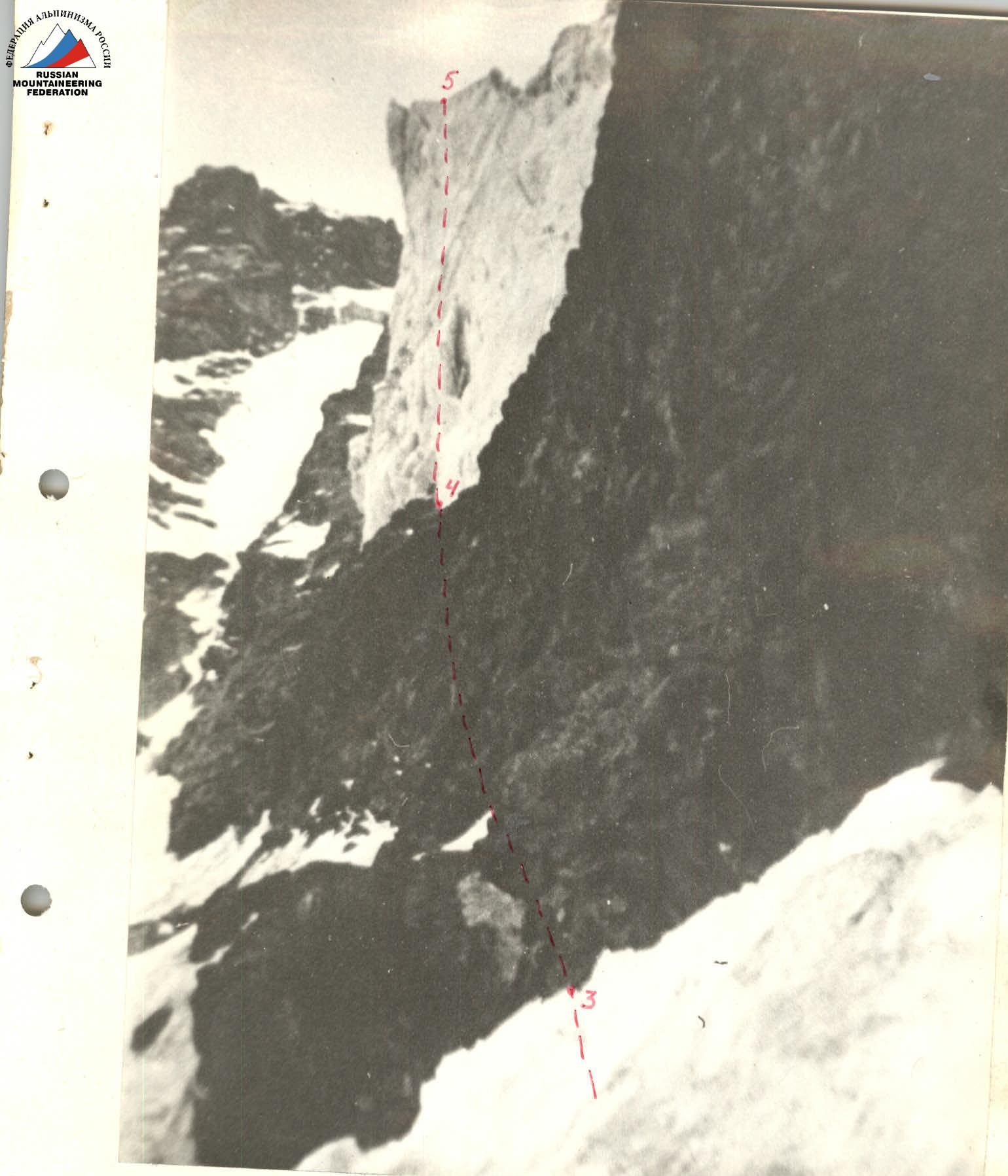
Photo 7. Section R3–R5. Taken on July 18, 1983, at 5:30. Camera "Smena", F=40 mm.