I. Technical class 2. Central Caucasus 3. Ushba South peak via East face (Khatskevich route) 4. Proposed - 6B cat. diff., second ascent 5. Height difference - 1260 m, including wall section - 1075 m. Route length - 1600 m, wall section - 1275 m. Average steepness of main wall section - 75° (3550–4250 m)
of which 6B cat. diff. -
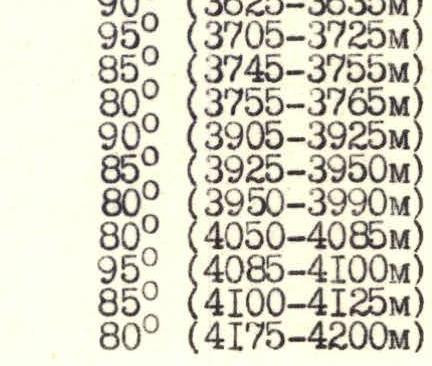
- 85° (3615–3625 m)
- 90° (3625–3635 m)
- 95° (3705–3725 m)
- 85° (3745–3755 m)
- 80° (3755–3765 m)
- 90° (3905–3925 m)
- 85° (3925–3950 m)
- 80° (3950–3990 m)
- 80° (4050–4085 m)
- 95° (4085–4100 m)
- 85° (4100–4125 m)
- 80° (4175–4200 m)
- Pitons driven: rock 214/79, bolt 1/1, chocks 123/59, ice screws 4/0
- Team's working hours - 79, days - 10
- Overnights in tents: 1, 2, 3 - in a snow col under a rock bastion; 4, 5 - on platforms laid out on a rock-scree ridge; 6, 7, 8, 9 - on platforms cut out on rock-ice ridges.
- Team leader - Ivanov Alexander Vasilyevich, Candidate Master of Sports
Team members:
- Melnik Vladimir Grigorievich, Candidate Master of Sports
- Goryun Alexander Nikolayevich, Candidate Master of Sports
- Kozlovsky Sergey Ivanovich, Candidate Master of Sports
- Melnikov Andrey Andreyevich, Candidate Master of Sports
- Tolstov Nikolay Petrovich, Candidate Master of Sports
- Team coach - Markov Valery Grigorievich, Honored Coach of the RSFSR
- Departure to the route July 23, 1986, summit - August 1, 1986. Return to base camp August 3, 1986.
- "Dzhailik" Alpine Camp
 General photo of the summit on July 22, 1986, 14:00, T-43 4/40 lens, shooting point #2, 3 km, 3000 m.
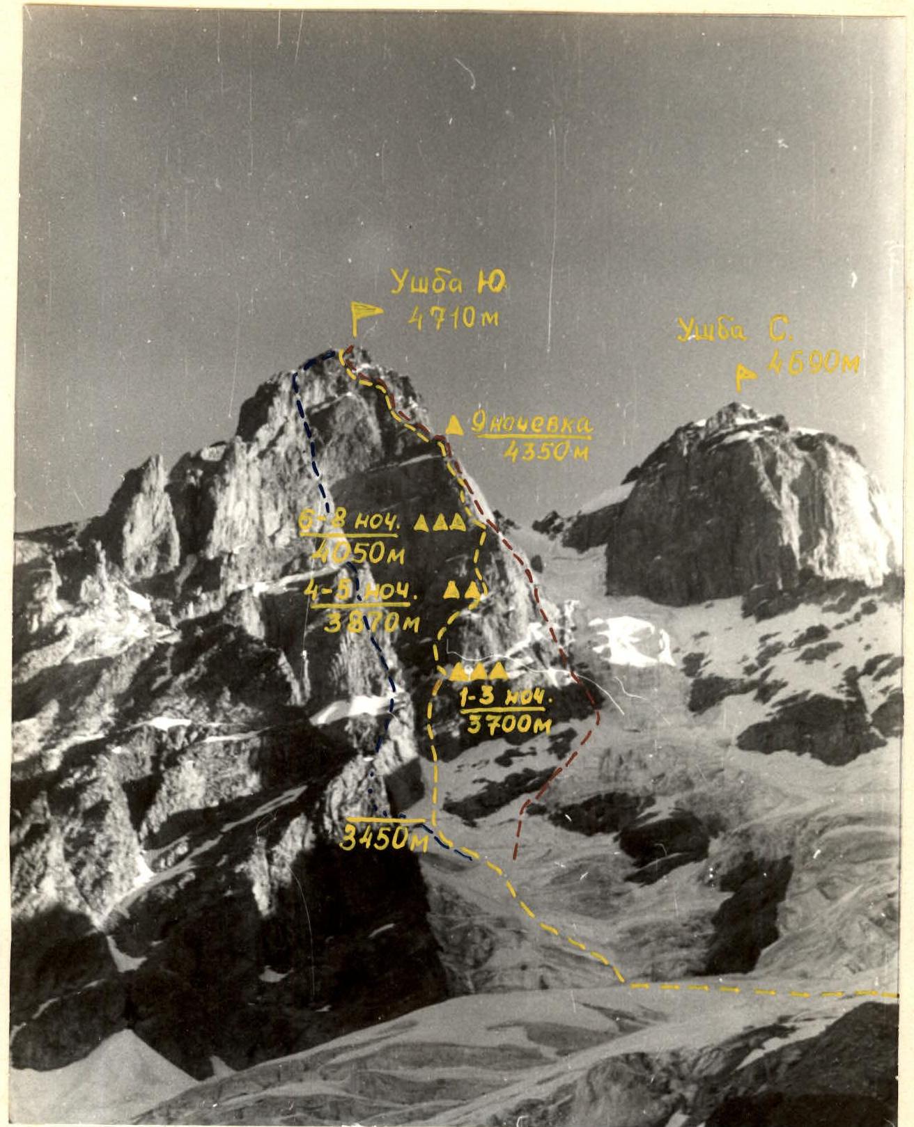
- --- team's ascent route
- --- Nekrasov's route 5B cat. diff., documented.
- --- Tkachenko's route 5B cat. diff., documented.
THE WALL PROFILE ON THE RIGHT CAN ONLY BE CAPTURED ON FILM FROM THE SUMMIT OF Ushba North, WHERE THE CLIMBERS DID NOT GO.
Profile of the wall on the left on August 2, 1986, 18:00. T-43 4/40 lens. Shooting point #4, 1 km, 3700 m. A — bivouac site
Team's Tactical Actions
The tactical plan for the ascent envisaged (see climbing sheet):
- July 20 — departure from alpine base. Crossing Becho pass. Overnight at South Shelter.
- July 21 — approach to base camp location on the left-bank moraine of Gul glacier.
- July 22 — preparation day for departure on the route. Reconnaissance. Photographing the route.
- July 23 — departure from base camp at 6:00 towards the East face. Start of work on the wall at 8:00. Reaching the overnight location under the rock bastion by 18:00 (p. 7 — hereinafter, section numbers refer to the updated UIAA scheme, see sheet 8).
- July 24 — processing the rock bastion (100 m). Overnight at the same location.
- July 25 — ascending via fixed ropes to the second bivouac location under the second rock belt (p. 15). Processing the second rock belt (100 m).
- July 26 — traversing the fixed ropes and moving further to the third bivouac location (p. 21). Processing 100 m on the rock triangle.
- July 27 — ascent to p. 29. Setting up an overnight camp.
- July 28 — summit ascent.
- July 29-30 — reserve days for bad weather.
- July 31 – August 1 — descent from the summit via 5A cat. diff. route (through "Red corner") to base camp.
- Alternative descent route — via Gabriel Hergiani's route 5B cat. diff.
- Emergency descent — via the ascent route.
- August 3 — return to alpine base.
It was planned to have an observation and relay group of two people directly under the route. In case of unstable radio communication with the base, an auxiliary group was to ascend Ushba South peak via the "Red corner".
Team's Actions
On July 20, in accordance with the tactical plan, the entire team and observers departed from "Dzhailik" alpine base at 10:00. On July 22, at 12:00, the groups arrived at the base camp location on Gul glacier. On the same day, reconnaissance was conducted in the upper Gul glacier area and on the southern spur of Gulkha peak to photograph the objective. On July 23, at 6:00, the team departed from base camp towards the East face of Ushba South. At 11:00, traversing Gul glacier, they reached the bergschrund under the wall. From this point, technically complex work on the route began. Access to the steep snow slope above the bergschrund was gained via a two-meter vertical snow wall. By 12:00, the group gathered at the base of the wall. The first rope team, Melnik — Goryun, started working. By 20:00, the group had covered sections R0–R10 (see photo 1). The most challenging sections were 4–5, as they were worked under a virtual waterfall from the snow slope above. The bivouac was set up in a snow col under the lower cornice of the rock bastion (see photo 2). On July 24, the group clarified the route in the morning, as the description by the first ascenders was unclear regarding where to start moving up the bastion. At 12:00, a control cairn left by the first ascenders was found. By 13:00, the ascent path was clarified, and the rope team Tolstov — Melnikov began processing the route (see photo 3). By 14:00, the weather deteriorated sharply, with snow, graupel, and a thunderstorm. The rope team continued working on the wall until 18:00 but had to descend to the bivouac. They processed sections 9–11 (40 m total) during the day. On July 25, the weather was already bad in the morning — graupel and fog. At 9:00, the rope team Goryun — Kozlovsky started processing the route. By 16:00, in severe weather conditions, they managed to process another 80 m of the bastion (sections 11–15). The continuing bad weather did not allow the group to ascend to the planned bivouac location. It was decided to use the first reserve day for bad weather and spend the night at the same location. On July 26, in the morning, there was fog, with graupel at times. At 9:00, the group ascended via fixed ropes (see photo 4). By 11:00, the weather deteriorated again — a squally wind with heavy graupel and a thunderstorm. In these conditions, the group reached the second planned bivouac location by 18:00. Platforms for tents were cut out in a rock-ice ridge under the wall (see photo 5). Using a temporary improvement in the weather, the rope team Melnik — Ivanov processed 40 m on the second rock belt in 2 hours (sections 16–17). On July 27, at 9:00, the rope team Melnik — Ivanov started further route processing. From 10:30, the weather deteriorated again — graupel, thunderstorm, visibility 30–40 m. The rope team worked until 15:00, processing 120 m (sections 16–20) including the previous day's progress, and descended to the bivouac. The thunderstorm continued, and the group decided to use another reserve day for bad weather. On July 28, the weather was good in the morning. At 9:00, the group started ascending via fixed ropes. The section 20–21 above the ropes was first traversed by the rope team Tolstov — Melnikov. By 18:00, the group gathered under the "rock triangle" (section 21). The bivouac was set up on a rock-and-ice shoulder of the wall. By this time, the weather had deteriorated again — fog, snow. Lack of orientation did not allow the group to start processing the route (see photos 5, 6). On July 29, from 9:00, the rope teams Goryun — Kozlovsky and then Melnik — Ivanov started processing the wall. By 17:00, they managed to process 200 m (sections 21–28). Continuing bad weather — snowfall, occasional thunderstorms — again prevented the group from ascending to the planned bivouac location in full force. In such weather conditions, an ascent could have led to an unplanned bivouac (possibly a hanging one), putting the group on the brink of an emergency. Considering this, the group decided to take another day for bad weather, not planned in the tactical plan, and spend the night at the same location. On July 30, there was a thunderstorm throughout the night and for more than half of the day, with snowfall. About 70 cm of snow fell. The group had to stay at the bivouac, effectively taking a second unplanned day for bad weather. The reserve of fuel and provisions allowed them to do so. On July 31, the weather was good. The group traversed the fixed ropes and approached the snow-ice knife (sections 30–31) by 18:00. Sections 28–30 were first traversed by the rope team Melnikov — Tolstov. Platforms for tents were cut out in the ridge of the knife. By 21:00, the same rope team processed sections 31–34. Via radio communication with the alpine base, the group received permission to extend the control return date to August 5. On August 1, from 9:00, the group worked on the route in full strength (see photos 7, 8). The rope team Tolstov — Melnikov led. At 16:00, the group reached the summit and started descending via the "Red corner". On August 2, having clarified the snow-ice conditions on the descent route ("bare" ice, frequent rockfall along the "necktie"), the group decided to switch to the alternative descent route via Gabriel Hergiani's route (see photo 9). On August 3, at 14:00, the group returned to base camp. On August 5, having crossed Becho pass, the group returned to the alpine base.
Fixed ropes were set up on sections R1–R7, R9–R15, R16–R40. A note from the first ascenders was found on R9. From the summit, a note from a group of instructors from the alpine school under the leadership of Emelyanenko Yu.S. dated July 22, 1986, was retrieved. There were no falls or injuries. There were no breaches of the radio communication schedule.
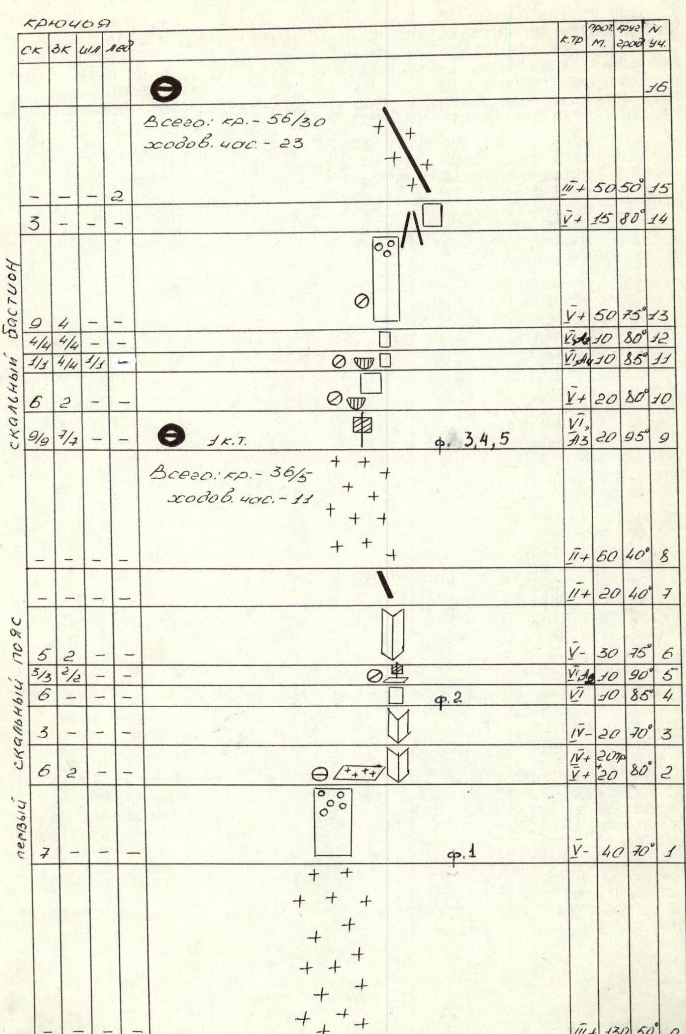
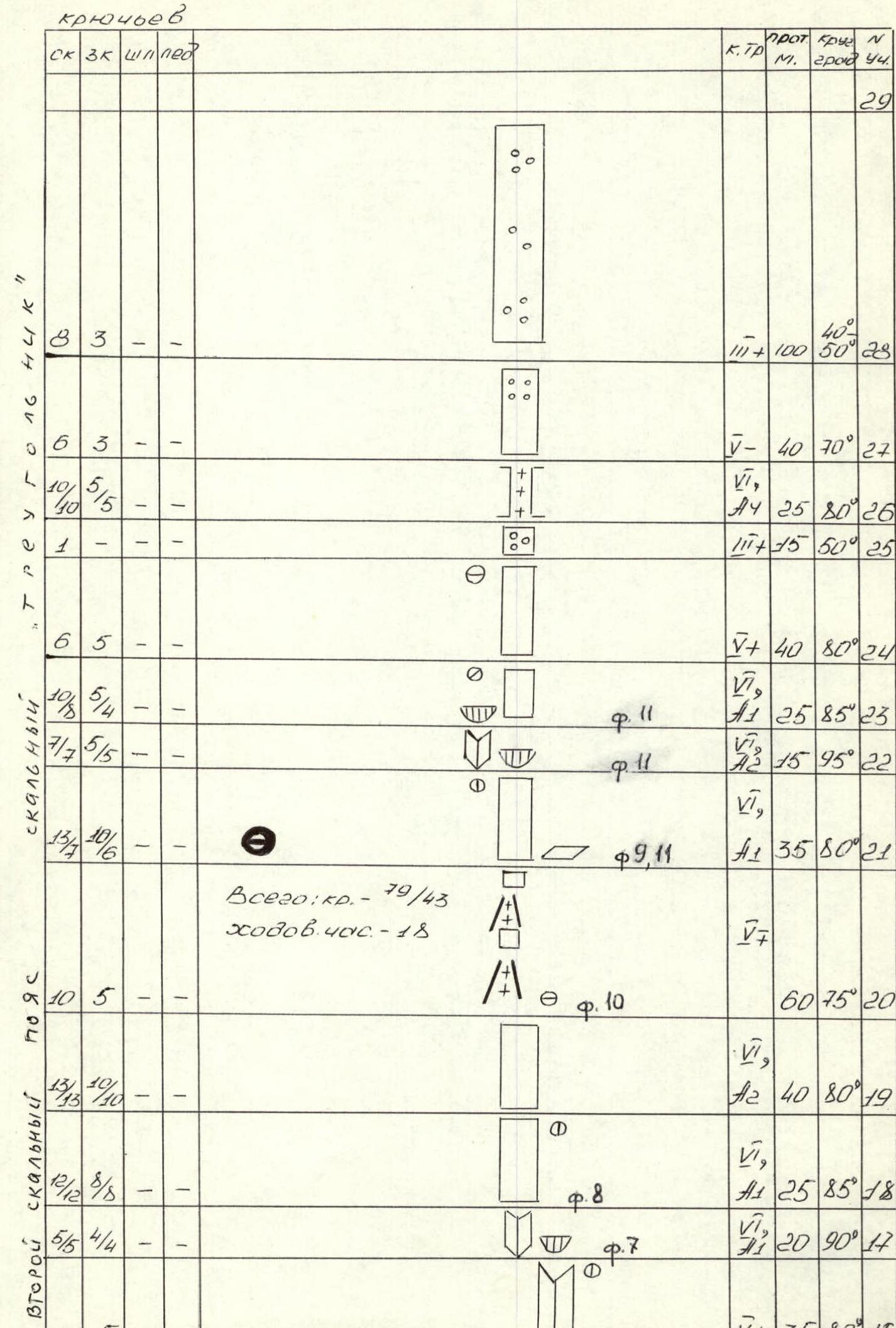 Photo 4. View of the lower part of the rock bastion (sections 9–11). The arrow points to the first climber in the rope team on R10.
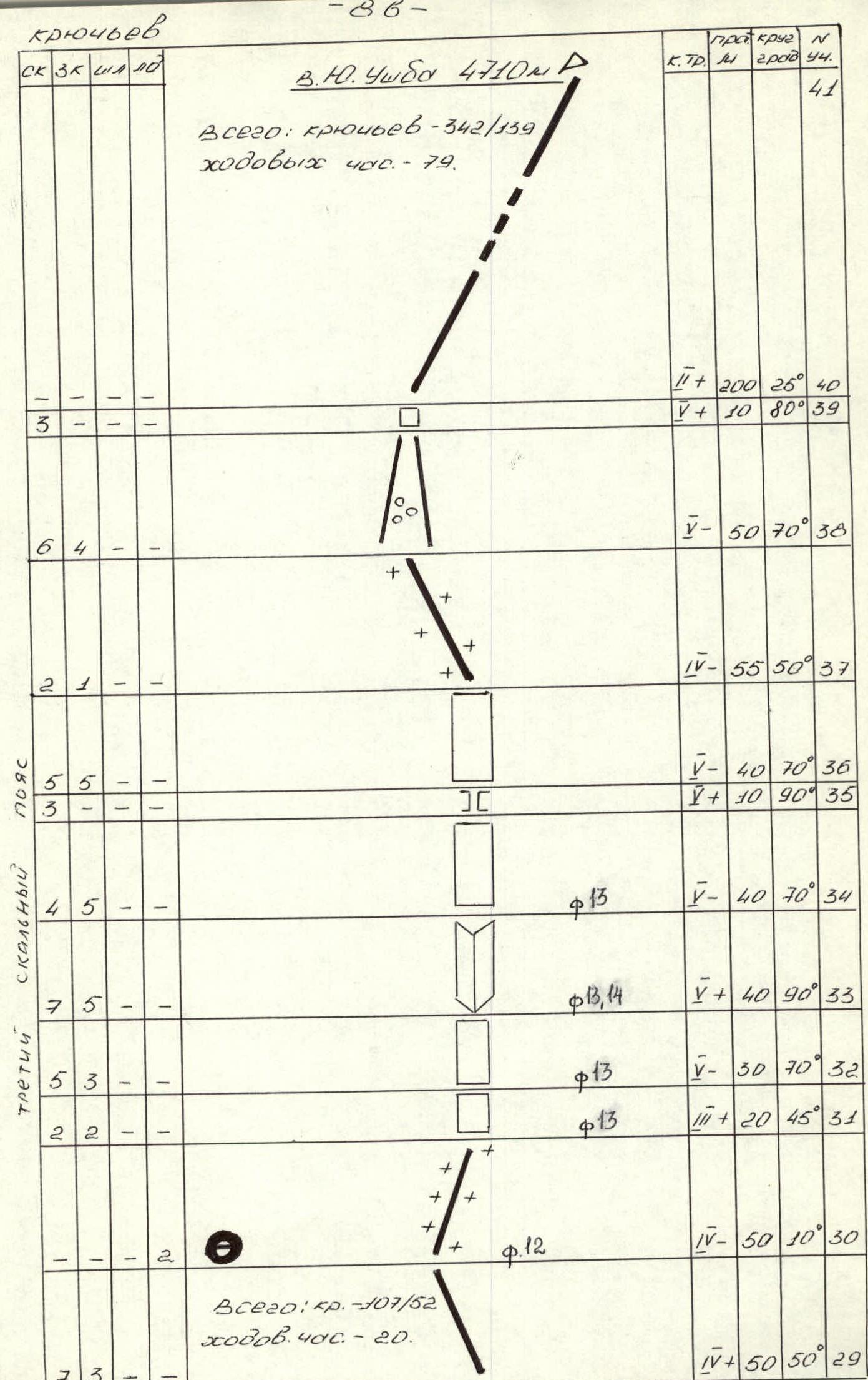 Photo 6. View of the lower part of the "rock triangle" (sections 21–23).
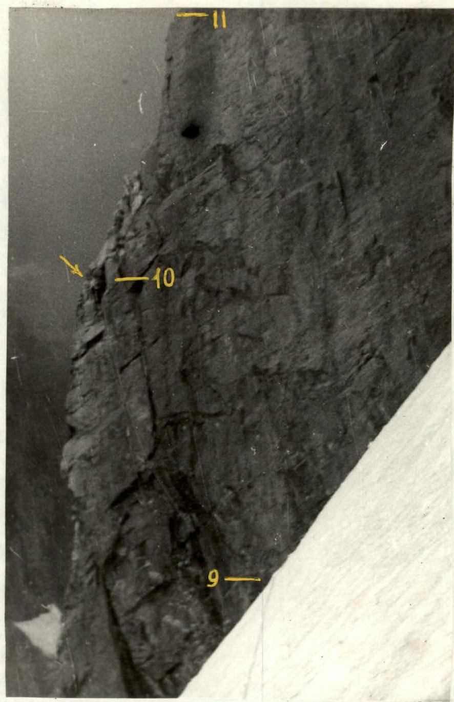
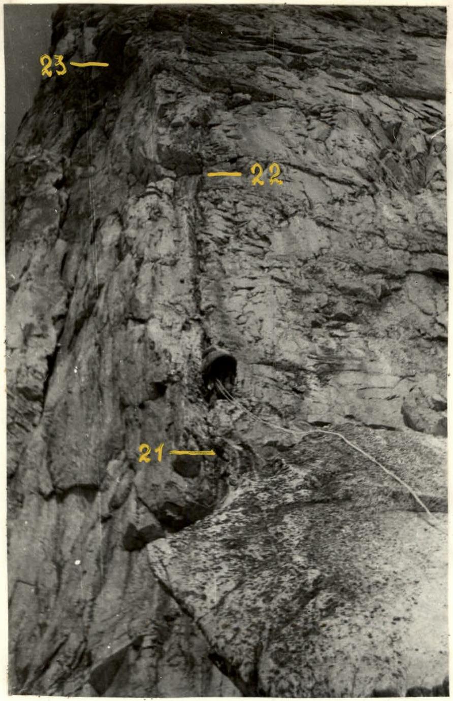 Photo 12. Bivouac site on sections 30–31 (snow knife).
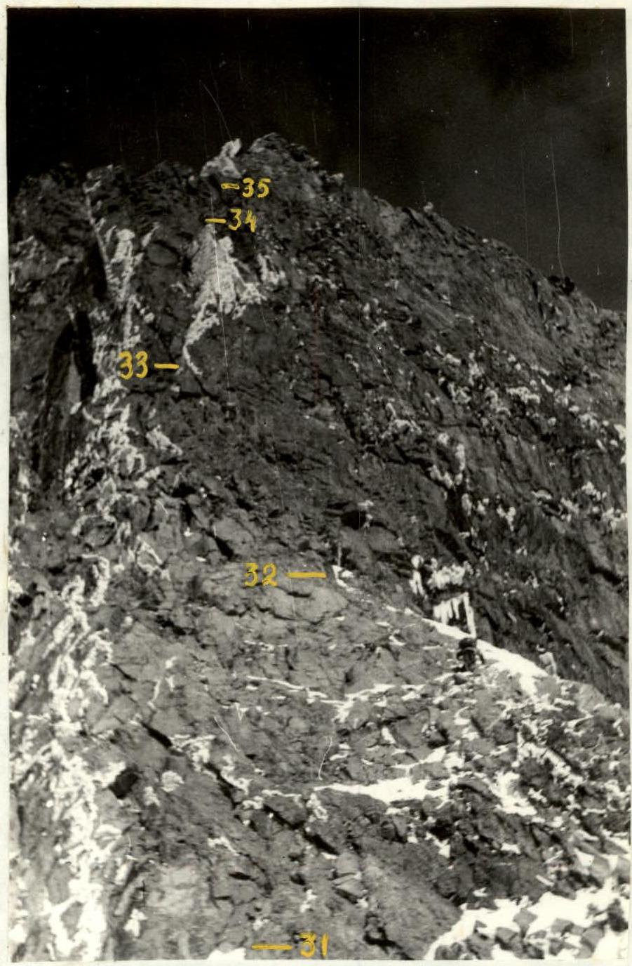
 Photo 13. Third rock belt (sections 31–35).