v. USHBA SHIKHANA, 4710 m via NW edge, cat. diff. 5B, G. Zhivlyuk's route, 62
Height difference — 2000 m, average steepness — 65°, length of sections with category VI difficulty — 120 m, V — 180 m, IV — 820 m, III — 450 m. Trekking hours — 47. Number of bivouacs — 3. Climbing leader — Nasonova E.T. Climbing date — 9:00–14:00, 1982.
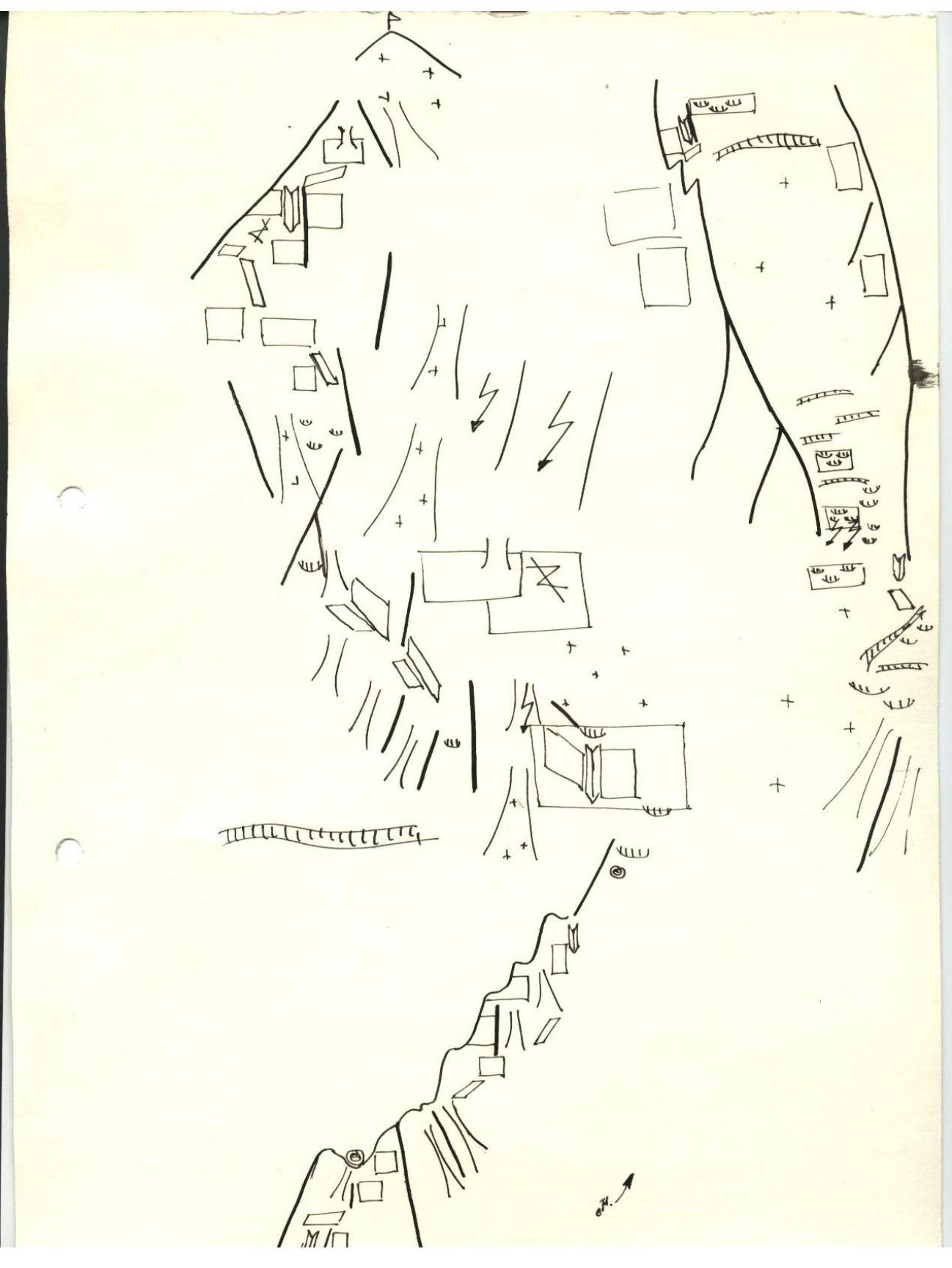
Recommendations: From "Ohotnichye bivouacs" or from the moraine of Ushba glacier, a hanging glacier is clearly visible, located to the right of the leftmost rocky edge of the NW wall D. of Ushba. The hanging glacier and the NW edge, abutting against the sheer walls of the "bastion", are good landmarks on the lower half of the route. The length of the edge to the "bastion" is about 1500 m. The path along the summit tower is clearly visible from the side of Ushba pass. It is mainly a diagonal traverse along a wall covered with flowstone ice with a steepness of about 70°. The length of the route along the tower is 1000–1100 m. The main technical difficulties are encountered when bypassing the tower. The western orientation of the wall contributes to the fact that the group gets "tired" late and does not have time to make a comfortable bivouac. It is recommended to set up a bivouac no later than 16:00.
Route description:
From the bivouac on the moraine of Ushba glacier, we head to the small glacier descending from under route D. Grigorenko — Prigoda. From the small glacier, we cross the rocky edge in its narrow part (160 m of category III–IV rocks) and get to the hanging glacier. We ascend the lower part of the hanging glacier, broken by crevices, onto its plateau and then, after 350–400 m along the snowy plateau, we reach the NW edge.
On the edge, we first follow the crest for 90–100 m to approach the rocky ascent. By bypassing the rocky ascent walls on the right (450–500 m of category IV–V rocks, occasionally VI), we reach the area of "teeth", where the edge becomes noticeably gentler and breaks into separate islands of gendarmes.
Here, bivouacs are possible, the best of which are located:
- in the gap (4 ropes below the junction of Zhivlyuk's and Artsishevsky's edges);
- 60 m after the junction of the edges.
After the edges merge, we mainly have to move with overlaps on the right. The gendarmes are bypassed along icy slopes or rocks heavily covered with flowstone ice.
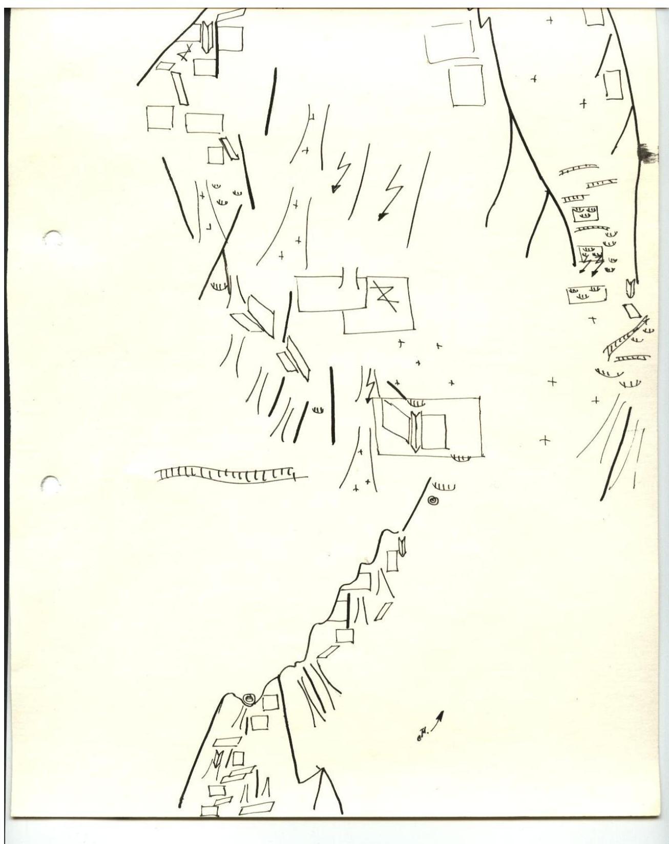
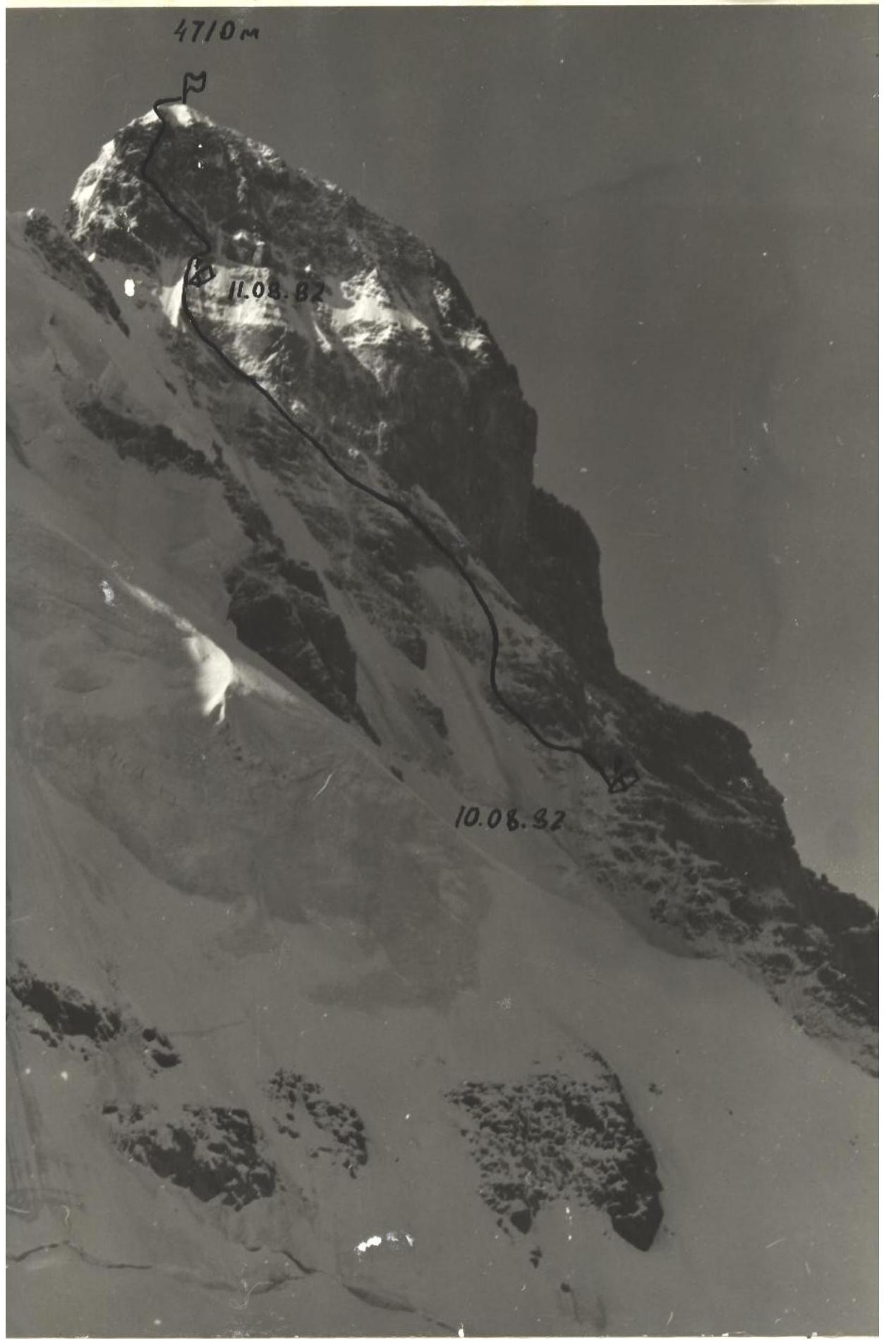
To the walls of the "bastion" there are about 500 m of category IV–V rocks and steep snow-ice sections. 80–100 m before the "bastion", it is necessary to turn left. At the turn, it is recommended to set up a bivouac and think about the path ahead — ahead lies a difficult section, and there will be no convenient platforms until the very summit.
After the turn:
- 80 m of complex, ice-covered rocks to the couloir;
- a steep ice couloir is traversed to the left under the base of the rocks;
- then, along a 60° ice slope, after 70–75 m, we exit under the rocky wall — the left edge of the bastion.
Along the wall, on weakly pronounced frozen ledges (traverse steepness 65–70°), we traverse the northern slope of the tower, gradually gaining height. After 350–400 m, we will exit onto a steep 60–65° snow slope-knife, dividing the wide groove of the northern wall of the tower. On the snow knife, it is possible to carve out a platform for a sitting bivouac.
Along the knife, 90 m under the rocky walls. Along the ledges and walls, we move left in a diagonal traverse (about 250 m) to the middle part of the NE edge (Ushba traverse path).
After exiting onto the NE ridge, there remain:
- 2 ropes of steep rocks;
- 100–120 m of simple snowy ridge to the summit.
Descent from the summit of Ushba Dzhanaya through "Krasny ugol".
When you ascend Ushba via the NE ridge, note that three ridges converge at the summit:
- from the left, from Svaneti, the NE ridge approaches,
- from the right, the WNW ridge approaches.
The descent should be conducted until the WNW ridge, along which the path passes, branches into a system of ridges and couloirs. At the end of the ridge, there are traditional bivouacs (from the summit, approximately 400 m along category I–II rocks). Here is one of the crucial points of the descent, where it is easy to get lost.
Try to move away from the platforms to the right, down the direction of movement, and about 80–100 m from the platform, find rappel anchors.
Ahead, there will be 3 rappels down sheer faces (landmarks can be light rocks along the descent path and a huge number of old rusty hooks in them, especially on the 2nd and 3rd rappels):
- 1st rappel — 45 m,
- 2nd rappel — about 35 m,
- 3rd rappel — 45 m.
After the 3 rappels, it is necessary to descend 150 m along a weakly pronounced rocky edge. Here, 3–4 sport descents may be required if the rocks are snowy.
Now, you need to look to the left. There should be a 20 m "rappel" onto a rocky terrace, explaining the rocky sheer faces located to the left of the descent path. The terrace connects to an extensive snow-ice slope after 50–60 m, which steeply descends along the Ushba — Mazeri ridge. This is the so-called "tie", along which you need to descend approximately 500 m to the saddle below Mazeri notch (more than half of this path may involve sport descents if icy; and on foot if dry).
From the bivouacs to the "tie" — 8 sport descents.
In the lowest part, we cross the saddle to the left under the rocky wall and, along a rocky ledge, bypass Mazeri notch from the west to the east. Along the ledge — two ropes (until the end of the possible traverse).
From here, there will be 3 descents down sheer, sometimes overhanging walls. The descents will lead to the slope of the glacier, 20 m west and below Mazeri pass.
 +4 +4
+4 +4
f₁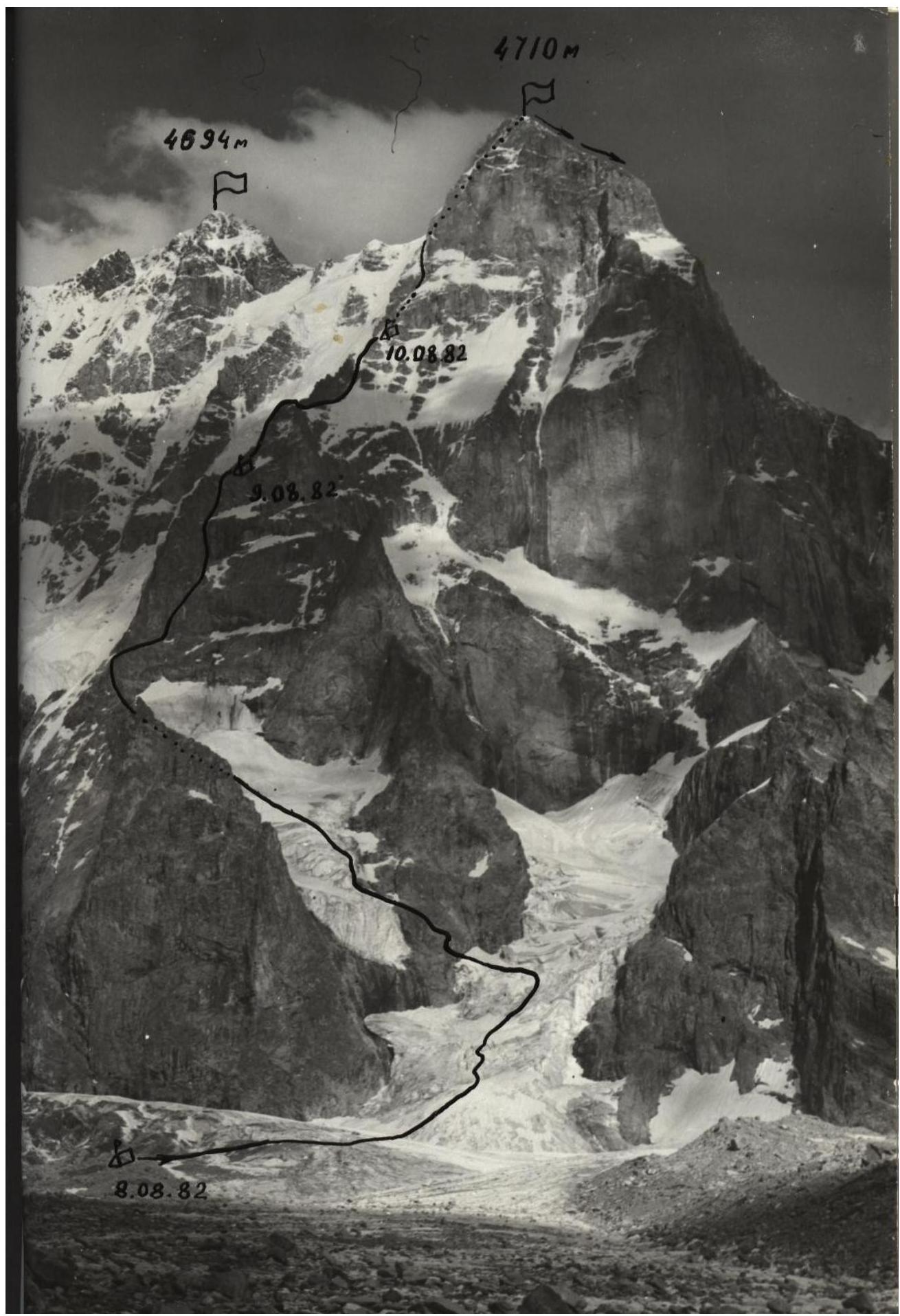 409.82
 □
□