Ascent Certificate
-
Class: winter
-
Ascent area: Caucasus, Prielbrusye
-
Ushba North via Northwest wall
-
Category of difficulty: 6A
-
Route characteristics:
-
Elevation gain: 1700 m (by altimeter)
-
Route length: 2550 m
- Length of sections with 5th category of difficulty — 1370 m
- Average steepness: main part of the route — 56°, entire route (from bivouacs) — 48°
-
Pitons used:
- Rock pitons — 0/0
- Nuts — 4/0
- Ice screws — 75/0
- Bolt pitons — 0/0
The denominator indicates the number used for artificial climbing holds. – Reuse of previously driven pitons.
-
Left on the route:
- Rock — 0
- Nuts — 0
- Ice — 1
- Bolt — 0
-
Team's climbing hours: 15 hours and 2 days
-
Number of bivouacs:
- 1 — a platform carved on a snow cornice 20 m from the summit.
-
Team leader: Abramov Aleksandr Viktorovich, Master of Sports of the USSR
-
Participants: Kochetkov Ruslan Yuryevich, Candidate for Master of Sports; Bruskov Konstantin Vladimirovich, 1st sports category
-
Coach: Abramov A. V., Master of Sports of the USSR
-
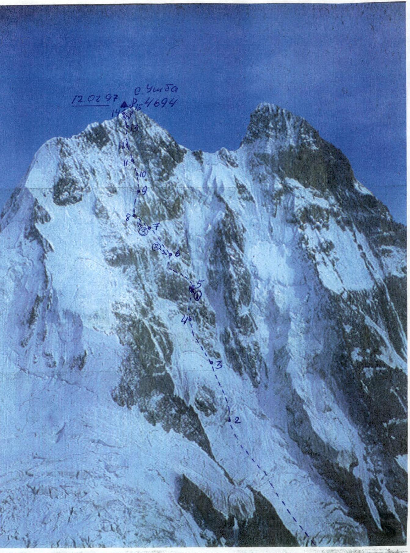
Departure to the route: February 12, 1997 Summit reached: February 12, 1997 Return to base camp: February 14, 1997
-
"International Expedition Center «Risk»
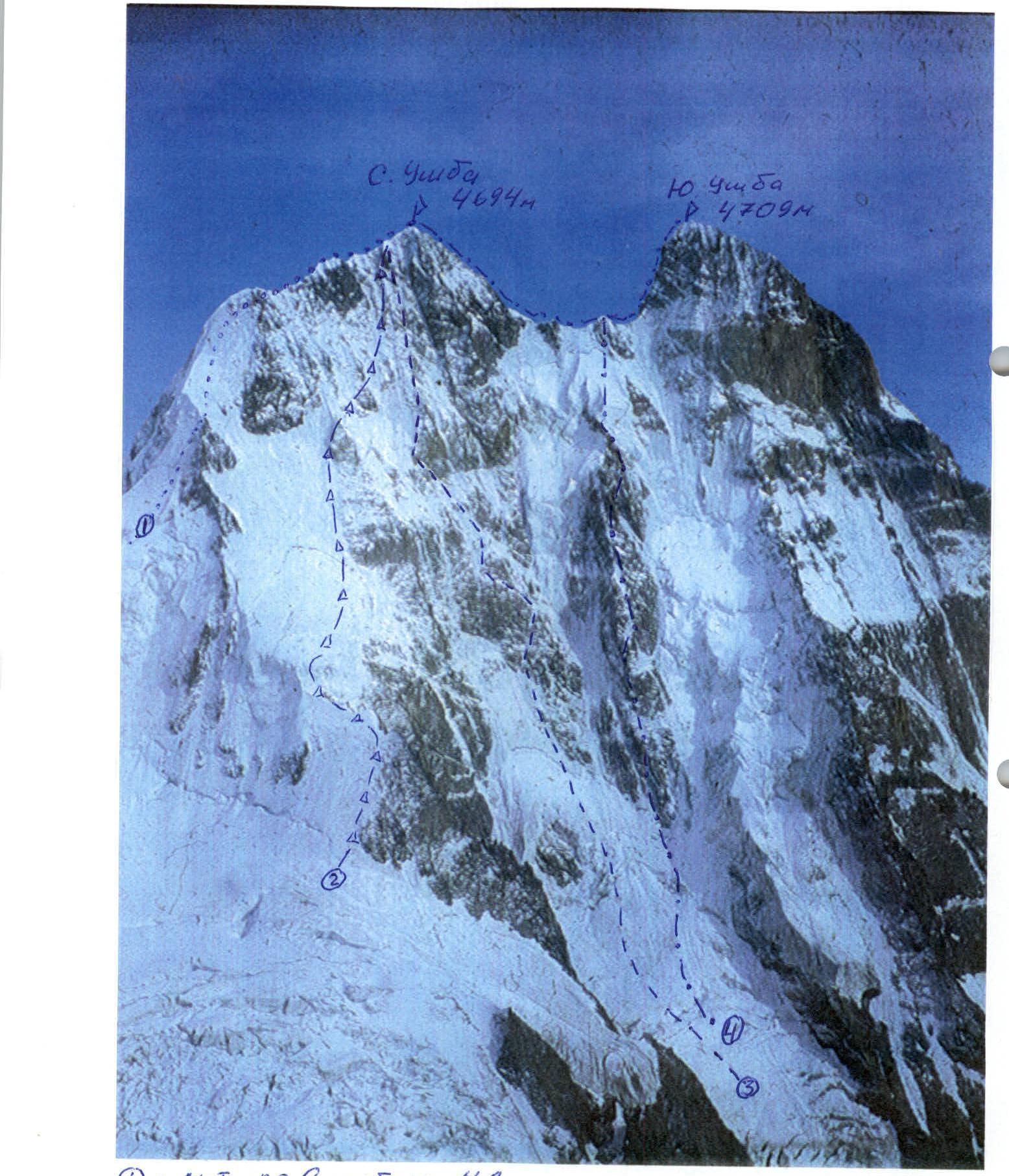 (1)
— M-T via S ridge 4A (2)
— M-T Erokhina, 1966 (incorrect) (3)
— M-T Kolomyttsev, 1982 (4)
— M-T "Krest Ushby"
(1)
— M-T via S ridge 4A (2)
— M-T Erokhina, 1966 (incorrect) (3)
— M-T Kolomyttsev, 1982 (4)
— M-T "Krest Ushby"
Approach
The ascent participants stayed at Shkhelda Base Camp, from where they departed on February 10, 1997, at 12:00.
On the first day, the team ascended to the area of "German Bivouacs" on skis by 16:30 and spent the night in a snow cave dug by previous teams.
During the approach, the team carried a primus stove to quickly melt snow. They planned to carry only a gas burner for the ascent.
On February 11, leaving their skis near the cave and tying themselves together with a rope, the rope team began moving through the Ushba icefall at 9:00. The condition of the icefall was satisfactory, except for the upper part, where they had to descend into a crevasse due to a hanging serac. This was the same spot where in the winter of 1995, a serac collapse killed 1 and injured 3 people. They reached a cave on the Ushba Plateau by 14:00, rested, had a substantial lunch, and left the primus stove and supplies for the descent. They began their descent to the South Shkhelda Glacier under the start of the route at 16:00 and set up camp by 18:30, almost in the dark. From here, the team departed for the ascent on February 12 at 2:00.
Team's Tactical Actions
Winter ascents on Ushba are considered among the most dangerous in the Caucasus, as confirmed by the sad statistics of recent years. Therefore, preparation for the ascent received utmost attention.
The team prepared for the ascent over 1.5–2 hours:
- In early January, they made a training ascent to the summit of Kurmychi.
- More than 15 training outings to the Kashka-Tash Glacier.
In February, all participants took part in the Moscow Ice Climbing Championship, where:
- Abramov took 1st place;
- Bruskov — 4th place;
- Kochetkov — 6th place out of 20 participants.
For acclimatization, a week before the ascent, the team spent a night at "Priyut-11" and ascended to the Scafell Rocks (4800 m) on Mt. Elbrus.
On February 10, the team of 3 climbers departed from Shkhelda camp and, after a night in a cave at "German Bivouacs," passed through the heavily crevassed, very dangerous Ushba icefall and crossed the Ushba Plateau. On February 11, they reached the bivouac sites under the Northwest wall of Ushba.
Since the weather forecast predicted a sharp deterioration in weather for the following days, and the strong frost down to -30 °C and wind made a cold bivouac unlikely to succeed, the team decided to make every effort to reach the summit in one day. The first ascenders organized a bivouac by digging a platform on a snowy slope; in winter, the entire route was icy, and snow started only near the summit.
Considering the route's considerable length and the daylight duration from 7:00 to 18:00, the team decided to start the route with headlamps at 2:00 to pass the relatively simple, though dangerous, section to the 1st rock belt by dawn. They also decided to frequently change the lead climber to maintain a high ascent speed.
Since the team consisted of 3 climbers, they formed a single rope team using:
- A single "Edelrid" (dry) rope — 50 m.
For rappelling, they used this rope along with a 50 m western-made cordelette.
On sections R4–R5 and R9–R11, Abramov led first. On sections R0–R3 and R12–R14, Bruskov led first. On sections R6–R8 and R15, Kochetkov led first.
The lower part of the route was a closed glacier. They put on crampons right by the tent, and since they were moving in the dark, the participants tied themselves together. The speed on this section was high as they moved simultaneously over firm snow. By 7:00, they reached the bergschrund under the 1st rock belt, where the main part of the route began.
The upper (main) part of the route consisted of very steep (up to 70°) ice-covered rock slabs. Thanks to the team's good ice climbing skills and equipment, they moved simultaneously on the ice. For protection, they used:
- Ice screws with handles, which the lead climber screwed in every 20–25 m. Thus, there were always 2 ice screws between the first and third climbers in the team.
- Nuts.
Under the 2nd rock belt, there's a control cairn. The team spent over an hour searching for it without success. They then left one of their ice screws, screwed in halfway under the rocks, and continued the ascent.
All icy sections were climbed simultaneously, with leader changes at belay stations made of two ice screws.
The pre-summit ridge proved very dangerous, with cornices and "vertical" loose snow. It was here that a team of 5 people fell in the winter of 1995 (all died).
At 17:20, at sunset, they reached the North summit, where they found a note from 14 Georgian climbers in a cairn. Leaving their own note, they began searching for a bivouac site.
With great difficulty, already in the dark, they chopped out part of a cornice on the ridge 20 m from the summit, where they managed to "stick" their tent. At night, they used a rope fixed to ice screws for self-belaying.
The descent to the Ushba Plateau went along the very dangerous North ridge in bad weather and poor visibility. The weather turned bad for a whole week after the ascent.
They maintained constant radio contact with Shkhelda Base Camp, which, by agreement, acted as a rescue team and guaranteed helicopter rescue operations.
Fortunately, there were no falls or injuries. On February 14, 1997, the team successfully descended to Shkhelda camp.
A long-held dream was fulfilled, as none of the three participants had ever climbed Ushba — the most beautiful Caucasian peak. Everyone was happy!
| Ice screws | Nuts | UIAA Scheme | Category of difficulty | Section length (m) | Steepness (°) | Section № |
|---|---|---|---|---|---|---|
| 10 |  | 250 | 50° | 4 | ||
| 9 |  | 3 | 200 | 40° | 3 | |
| 6 |  | 600 | 40° | 2 | ||
| – | – |  | 2 | 300 | 35° | 1 |
| 1 | 2 |  | 5 | 70 | 70° | 12 |
| 7 |  | 5 | 150 | 60° | 11 | |
| 4 |  | 5 | 100 | 50° | 10 | |
| 4 |  | 5 | 100 | 65° | 9 | |
| 2 | 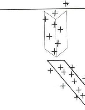 | 5 | 20 | 70° | 8 | |
| 8 |  | 5 | 200 | 45° | 7 | |
| 6 | 5 | 150 | 60° | 6 | ||
| 7 | 5 | 150 | 70° | 5 | ||
| 2 | 4 | 80 | 35° | 15 | ||
| 4 | 5 | 50 | 60° | 14 | ||
| 5 | 2 | 5 | 130 | 55° | 13 |
Route Description by Sections
| Section | Description |
|---|---|
| R0–R1 | Closed glacier, moving towards a gully in the middle part of the glacier. |
| R1–R2 | Steep snow-ice gully, then direction to the right of a hanging glacier above a small rock island. |
| R2–R3 | Bypassing the hanging glacier on the right along a steep ice wall and an icy slope to the left of rock islands under the bergschrund. |
| R3–R4 | Steep ice-firn slope. Length about 250 m. Problematic to organize reliable protection. Layered structure: ice crust alternates with ice chips. Attempts to dig to ice were unsuccessful. |
| R4–R5 | Up the ice "stream" to the right of the rock slabs of the 1st rock belt. Thin ice. Organization of intermediate belay points in filled crevasses. |
| R5–R6 | Left upwards under the "trapeze" along an ice shelf, then up a steep inner corner filled with ice. Exit above the "trapeze" onto a faint ice ridge. |
| R6–R7 | Ice ridge leading to the left part of the 2nd rock belt. "Bottle" ice. |
| R7–R8 | Left upwards between the slabs of the 2nd rock belt along an icy gully. Thin ice. |
| R8–R9 | Steep icy slope, moving between rock islands. |
| R9–R10 | Moving between the slabs of the left part of a steep rock ridge. |
| R10–R11 | Steep icy slope to the left of an overhanging rock wall under the base of a rock tower. |
| R11–R12 | Ice gully to the left of the rock tower. Thin ice. Ice screws and nuts were used for intermediate belay points. |
| R12–R13 | Ice ridge turning into steep rock slabs filled with ice. Protection organization on rock slabs using nuts. |
| R13–R14 | Steep firn gully. Exit onto the ridge — a snowy slope with 70° steepness. Very unreliable protection. |
| R14–R15 | Snow ridge. Cornices on the eastern side. A bivouac site was organized on the East ridge 30 m from the summit. |
Technical photo of the summit