Passport
- Class of winter ascents.
- Central Caucasus.
- North Ushba via northwest wall (Kolomyttsev V.G. route)
- 6A difficulty category.
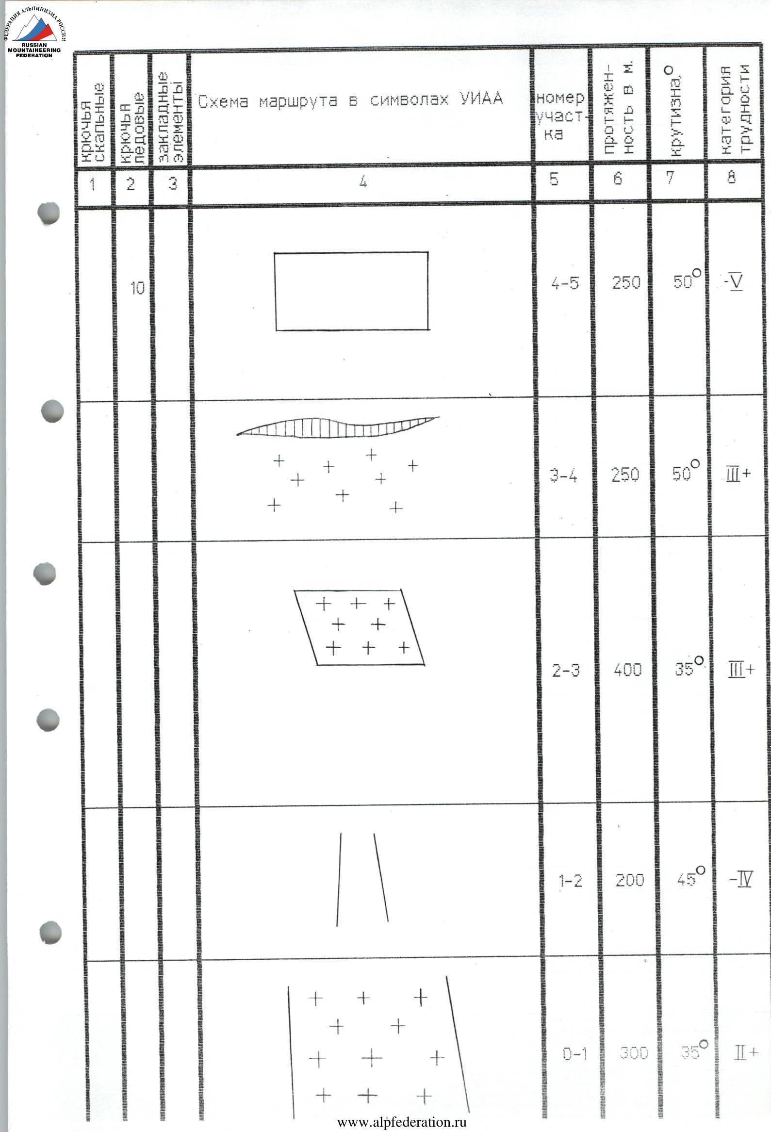
- Height difference — 1600 m.
Length 2300 m.
Length of sections:
- 5–6 cat. diff. — 1320 m
- 6 cat. diff. — 840 m
Average steepness:
- main part of the route — 47°30′20″
- key part of the route — 56°21′00″
- Pitons hammered: rock — 0, chocks — 8, ice screws — 68
- Climbing hours 24 h and 2 days
- Overnight stays:
1st platform carved on the end of a snow-ice ridge along the rocks of the second rocky belt
2nd platform on a snow-ice ridge below the summit
- Leader: Moiseev Alexander Anatolyevich — MS 344008. 1/2 Participant: Fedorenko Roman Viktorovich — CMS
- Coach: Pogorelov Alexander Grigoryevich — MSIC
- Departure to the route February 22, 1996
Summit February 23, 1996
Return February 24, 1996
- Organization: USC "Planeta" at the Sports club of the Rostselmash plant.
344029, 1/2, ul. 1-y Komosomolskoy armii,
4
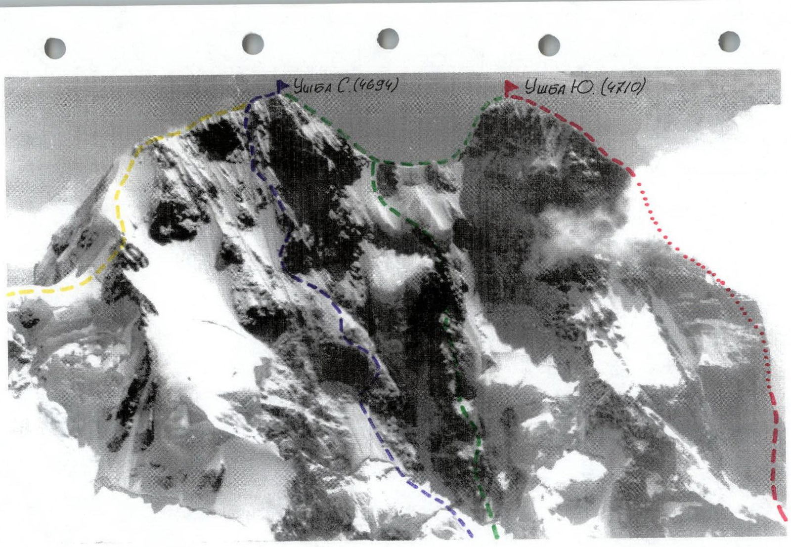
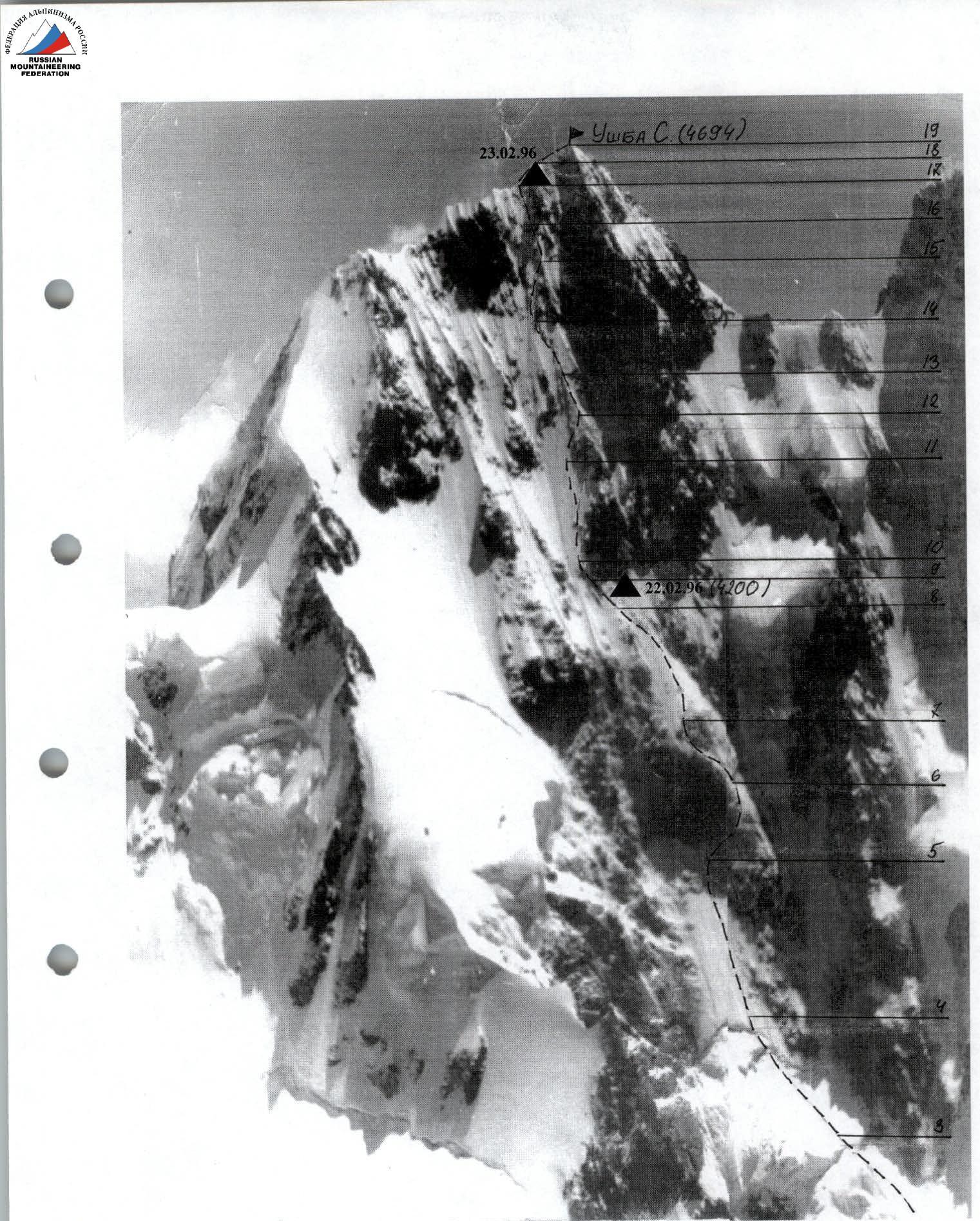
General photo of the summit.
Taken from the summit of Shkheldy V. Lens "Industar-61" f = 50 mm. Distance to the wall: 4.5 km. H = 3300 m. Shooting point #1.
- Ushba South via the right part of the SW wall (Kustovsky's route), 6B cat. diff.
- Ushba North, via NW wall (Kolomyttsev V.G. route), 6A cat. diff.
- Ushba North-South via NW wall and descent to Gul glacier, 6A cat. diff.
- Ushba North via NE ridge, 4A cat. diff.
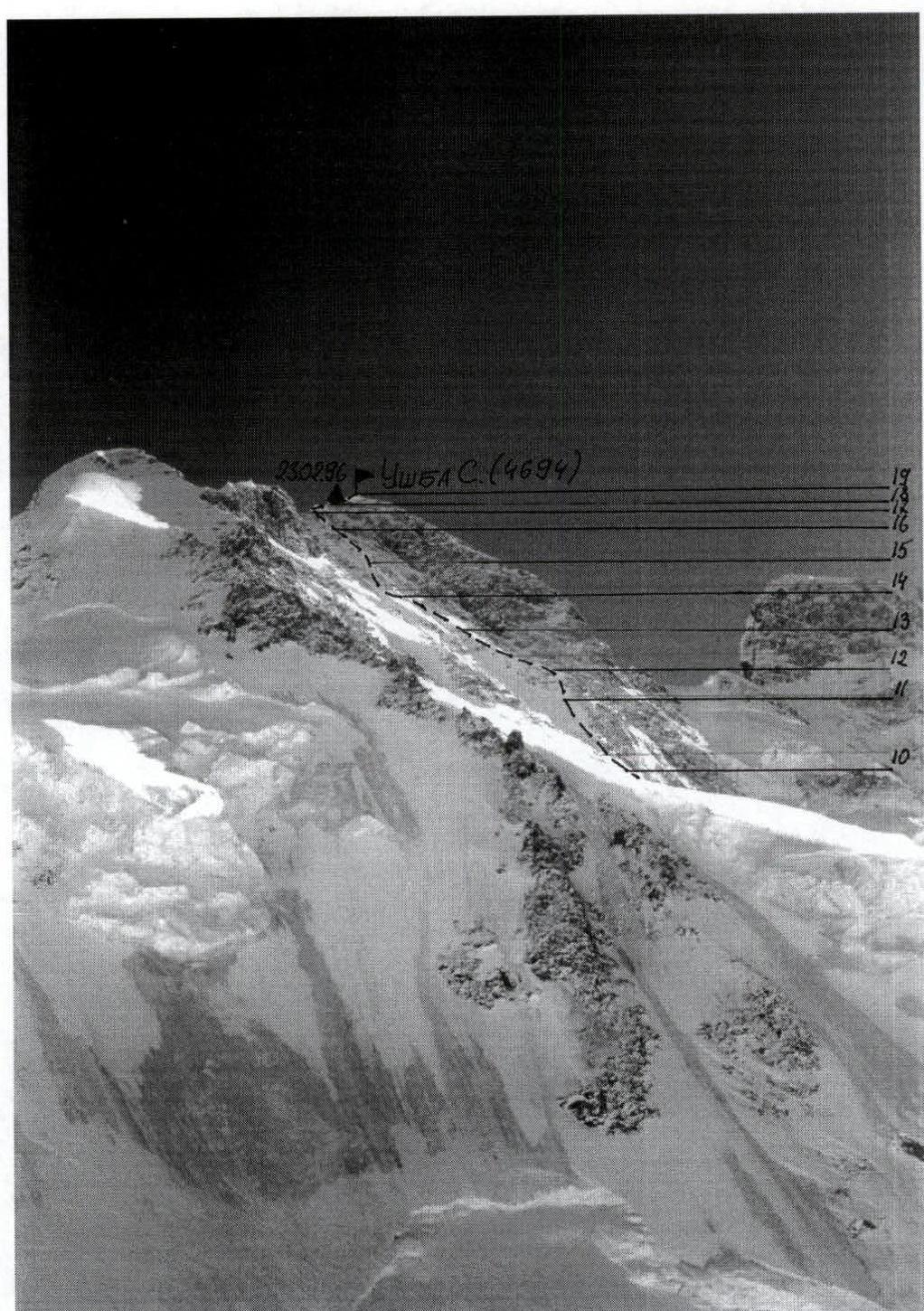
PHOTO 2. Profile of the wall from the left. February 22, 1996. Camera "Smena". F = 50 mm.
Shooting point 2.
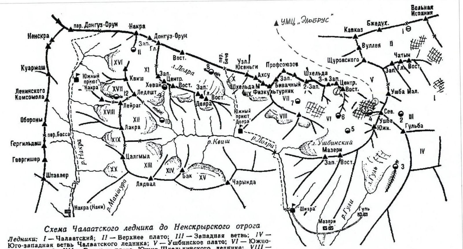
Scheme of Chalaat glacier to Neksyrsky spur
Glaciers:
- I — Chalaat
- II — Upper plateau
- III — Western branch
- IV — South-western branch of Chalaat glacier
- V — Ushba plateau
- VI — South-Shkheldy
- VII — Upper plateau of South-Shkheldy glacier
- VIII — South-east Kvam
- IX — Kvam
- X — Kerunda
- XI — Khezai
- XII — Kvish
- XIII — Tsalgmil
- XIV — Bak
- XV — Charinda
- XVI — Nakra
- XVII — Ledesh
- XVIII — Leyrag
- XIX — North Tsalgmil
- XX — South Tsalgmil
Initial base camps:
- 1 — Upper plateau of Chalaat glacier;
- 2 — Upper plateau of the Western branch of Chalaat glacier;
- 3 — Gul moraine;
- 4 — shoulder of the North-west counterfort of North Ushba;
- 5 — median moraine of Ushba glacier;
- 6 — Hunting grounds;
- 7 — Upper plateau of South-Shkheldy glacier;
- 8 — Dolra moraine;
- 9 — Khezai;
- 10 — Kvish;
- 11 — Nakrinsky;
- 12 — Ledesh moraine
- Ø — Shooting point
Description of the route by sections
R0–R1 Snow-ice slope, glacier. R1–R2 Ice-snow gully. R2–R3 Movement along the ice-snow slope towards the saddle between the peaks, bypassing the lower hanging glacier. R3–R4 Steep snow slope. R4–R5 Steep ice slope. Movement towards the ice gully in the right part of the rocky belt. R5–R6 Up it to the right, along the ice runoff, belay via chocks. R6–R8 Left under the trapezoid along a steep ice ledge, and then bypassing the rocks to the left along the ice-filled inner corner to exit onto the ice ridge. At the end of it, below the rocks, a semi-reclining overnight stay in a tent. R8–R9 Left upwards, bypassing the rocks of the second rocky belt to the left, towards the ice gully. R9–R11 Steep ice gully: straight up it, and then to the right towards the rocky ridge. R11–R12 Along the rocks covered with ice runoff, exit onto a long ice ridge. Belay via ice screws and chocks. R12–R14 Long ice ridge towards a large rocky tower. Porous ice. Belay via long ice screws. R14–R15 Bypass the rocky tower to the left, exit into a steep ice gully. Belay via short and medium ice screws. R15–R17 Along the ice slope and couloir, exit onto the pre-summit ridge of N. Ushba. R17–R18 From here, three ropes to the summit. The ridge is steep with cornices hanging to the east. Belay via ice screws and chock stones.
Technical photo of the route. Taken from the summit of Shkheldy, H = 4100 m. Lens "Industar-61" f = 50 mm. Distance 2.5 km. Shooting point #2.
- Ushba North. Via NW wall, 6A cat. diff. (Kolomyttsev V.G. route)
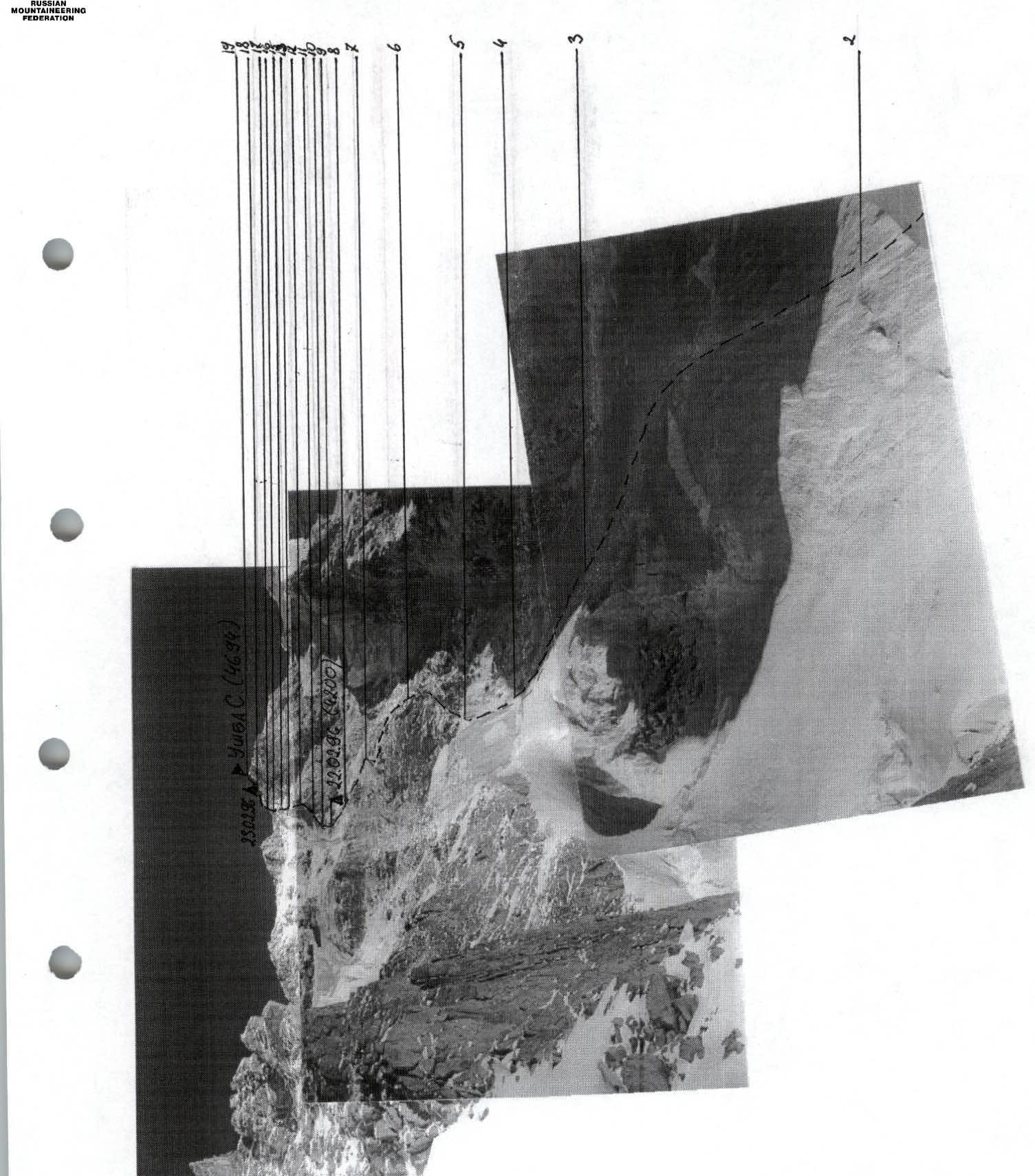
PHOTO 3. Technical photograph of the route. Camera "Smena". Shooting point 3.