- Category of ice and snow ascents.
- Central Caucasus.
- North Ushba via NW wall.
- Proposed route: 5B category of difficulty, first ascent.
- Elevation gain: 1600 m, length — 2300 m.
Length of sections with 5th category of difficulty — 1320 m. Average steepness: main sections — 58° (3800–4650 m), entire route — 49°.
-
Pitons driven: rock — 46, chocks — 18, ice screws — 49, snow anchors — 25.
-
Team's climbing hours: 25 days : 2
-
Overnight stops: 1st and 2nd bivouacs were dug out on a snow-ice slope.
-
Team leader: VLADIMIR GEORGIEVICH KOLOMYTTSEV, Master of Sports.
Team members:
- IGOR EVGENIEVICH GREBENSCHIKOV, Master of Sports;
- VASILY IGOREVICH ELAGIN, Candidate for Master of Sports;
- SERGEY KONSTANTINOVICH PENZOV, Candidate for Master of Sports.
Senior team coach: LEV NIKOLAEVICH DOBROVOLSKY, Master of Sports.
Coach: VLADIMIR GEORGIEVICH KOLOMYTTSEV.
Departure to the route: August 11, 1982.
Summit: August 12, 1982, return: August 13, 1982.

Taken from Shkheldy peak. H = 4100 m. July 23, 1977, 12:30. Distance = 2.5 km. "Industar-61" lens. Photo 1. General photo of the summit. F = 50 mm.
1 — route via N. ridge, 4A category of difficulty.
2 — I. Erokhin's route, 1956.
3 — L. Mishlyaev – V. Nikolaenko's route, 1958.
4 — "Ushba cross" route, 1972.
5 — L. Mishlyaev – O. Kosmachev's route, 1960.
6 — Yu. Zhivlyuk's route, 1962.
7 — Yu. Artsishevsky's route, 1971.
8 — Yu. Grigorenko – Prigoda's route, 1972.
9 — G. Shalaev's route, 1973.
10 — team's route.
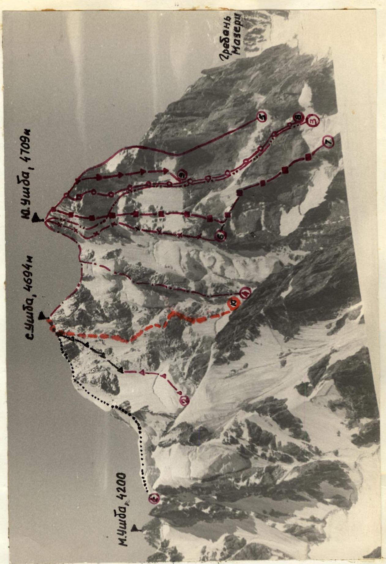
Photo 4. Photopanorama of the area. Taken from Fizkulturnik peak slopes. H = 3800 m. July 1965, approximately 15:30. "Jupiter-8" lens, F = 50 mm.
Team's Tactical Actions
On August 6, 1982, the team departed from "Shkhhelda" alpine camp and spent the night at the "German" bivouac site. On the 7th, they approached the route and bivouacked on the Ushba glacier. On the same day, a pair of observers, S. Kerbi and A. Ershov, departed from the camp. On August 8, the observers ascended to the Ushba pass and observed the upper part of the route from there. On the 9th, they joined the team. From August 7 to 10, the team observed the route. From August 10 to 11, the night was clear and quite frosty.
They departed at 1:30 in the following rope teams:
- Kolomytssev – Penzov;
- Elagin – Grebenshchikov.
As planned, they approached the bergschrund under the I rock belt at dawn, around 6:00. On this section, they moved quickly, with rope teams and leaders changing; the movement was simultaneous or alternating with protection via ice screws and ice axes.
On sections R1–R5, the Elagin – Grebenshchikov rope team worked first, and on sections R5–R8, the Kolomytssev – Penzov rope team worked.
On sections R3–R6:
- Movement on front points of crampons;
- Leader used ice axe and "shakal" ice hammer;
- Protection via ice screws and rock pitons;
- For more reliable passage, rope teams interacted: they moved along a fixed rope using a jumar and ice axe.
On section R5–R8:
- Ice screws, snow pitons, and Messner's shovel were used for protection;
- Penzov – Kolomytssev rope team led.
At 14:30, on the upper part of a snow-ice ridge between I and II rock belts, they began preparing a bivouac site using ice axes and shovels.
On August 12, after morning radio contact, they continued their ascent at 7:30. Under the 2nd rock belt, they organized a control cairn. The Kolomytssev – Penzov rope team worked first, periodically changing leaders.
On section R8–R11, the state of ice and snow is very specific:
- Ice is layered with loose snow interlayers;
- Ice thickness is 5–7 cm.
For protection, they used:
- long ice screws;
- snow pitons (in the form of long duralumin tubes);
- rock pitons driven into rare rock outcrops.
On section R8–R16, rope teams interacted. At 14:00, at point 12, during a radio communication session, they took a short rest and had a snack.
The weather was bad:
- snow;
- strong wind;
- fog;
- visibility up to 50 m. The state of snow in the upper part of the route resembled that of Tian Shan (snow is very loose, poorly formed).
There were steep, very sharp ridges. To ensure protection, they had to dig through snow to reach rock or ice. In the upper part, there were heavily destroyed rock sections covered with flow ice and snow. At 19:00, two rope lengths from the summit, they reached the N. ridge. It was very cold with a western wind. They decided to organize a bivouac near the summit on the leeward side. It took about two hours to prepare a site in the ice and snow.
The next day, the weather was almost winter-like, with a very strong wind. At 8:30, they began descending along the N. ridge and met the observers on the Ushba plateau at 14:00. At 19:30, they returned to the camp.
The first ascent of North Ushba via the NW wall was carried out in full accordance with the planned route and without deviating from the tactical plan.
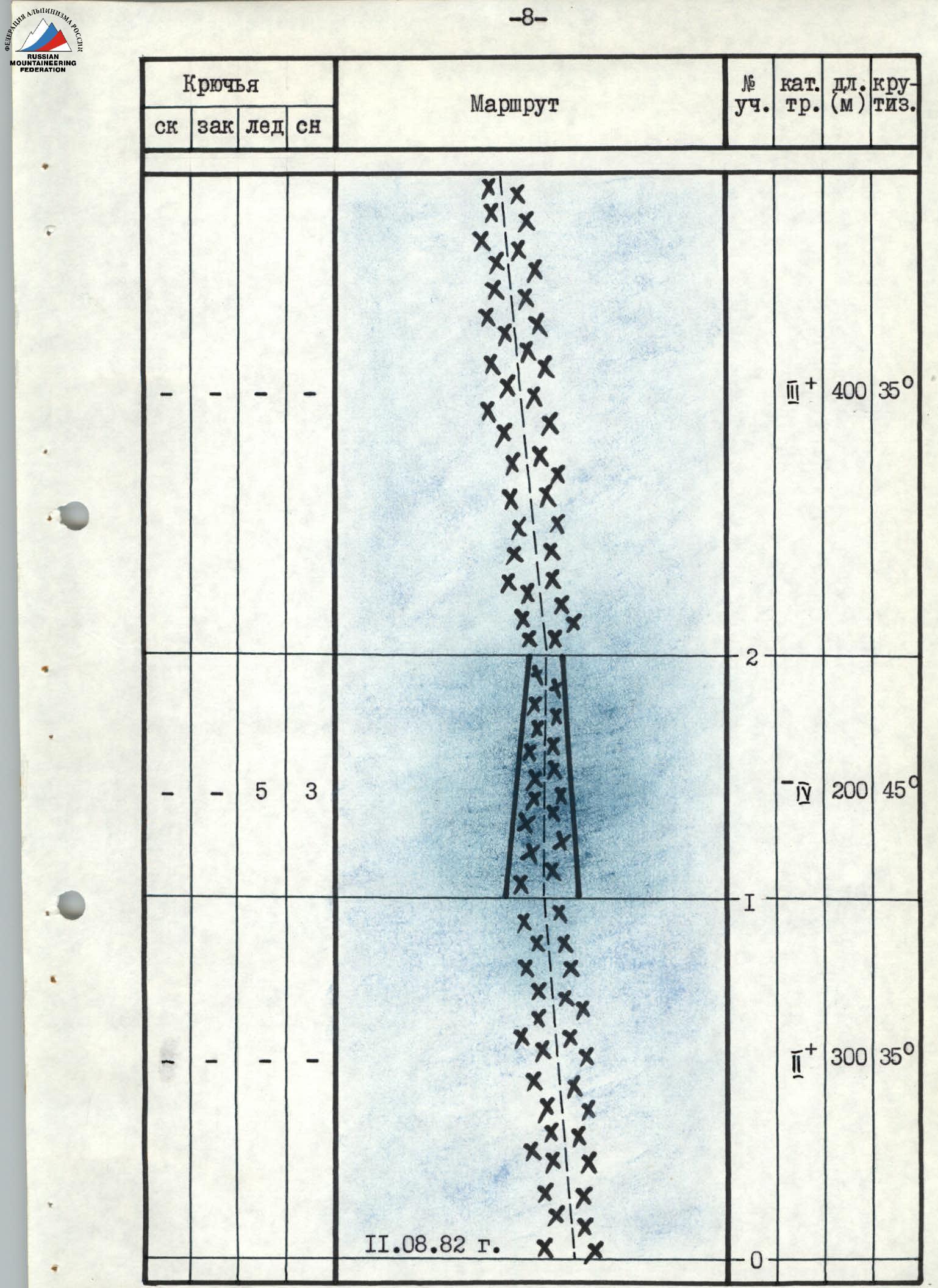
Route scheme in symbols. Scale 1:4000. Note: the scale of the scheme has been changed due to the large length and homogeneity of the relief on the route sections.
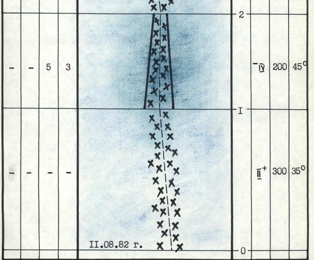
| Pitons rock | chocks | ice | snow | Route | Section | category of difficulty | length (m) | steepness | Scheme |
|---|---|---|---|---|---|---|---|---|---|
| - | - | - | - | R0 | + | 300 | 35° | ||
| - | - | 5 | 3 | R1 | - | 200 | 45° | ||
| - | - | - | - | R2 | + | 400 | 35° | ||
| - | - | 3 | 1 | R3 | + | 200 | 40° |  | |
| 5 | 1 | 8 | - | R4 | ▼ | 250 | 50° |  | |
| 7 | 2 | 5 | - | R5 | + | 160 | 70° |  | |
| 3 | - | 4 | 2 | R6 | + | 120 | 60° |  | |
| 3 | 1 | 4 | 2 | R7 | - | 140 | 45° |  | |
| 1 | - | - | 2 | № 1, 4200 m, August 12, 1982 | R8 | - | 60 | 45° |  |
| 2 | 1 | 2 | - | R9 | + | 20 | 70° |  | |
| Total | 18 | 4 | 29 | 8 | 1st day (13 climbing hours) | ||||
| 3 | - | 3 | 4 | R10 | + | 120 | 65° |  | |
| 2 | 1 | 2 | 4 | R11 | + | 80 | 50° |  | |
| 5 | 2 | 3 | - | R12 | + | 80 | 60° |  | |
| 4 | 2 | 2 | 2 | R13 | + | 80 | 55° |  | |
| 4 | 3 | 3 | - | R14 | + | 60 | 70° |  | |
| 3 | 1 | 3 | 2 | R15 | + | 140 | 55° |  | |
| 3 | 3 | 2 | - | R16 | + | 80 | 45° |  | |
| - | - | - | 3 | North Ushba 4694 m | R17 | ▼ | 80 | 30° |  |
| Total | 28 | 14 | 20 | 17 | 2nd day (12 climbing hours) | ||||
| TOTAL | 46 | 18 | 49 | 25 | Total |


Route Description by Sections
1st day. August 11, 1982.
Section R0–R1. Simultaneous movement along a gentle glacier with closed crevasses in the direction of a gully in the middle part of the glacier. Rope team composition: Elagin – Grebenshchikov; Penzov – Kolomyttsev.
Section R1–R2. Steep ice-snow gully with open and closed crevasses. Alternating protection, piton protection, as well as via ice axes and snow pitons.
Section R2–R3. Movement in the direction to the right of a hanging glacier above a small rock outcrop and to the left of a large hanging glacier to the left of the "cross" buttress.
Section R3–R4. Bypassing the hanging glacier on the right along a steep ice wall, then along a snow-ice slope in the direction to the left of rock outcrops under the I rock belt. The Elagin – Grebenshchikov rope team worked first. Protection via ice screws and snow pitons. We approached the bergschrund (point 4) at dawn.
Section R4–R5. Steep ice slope. Length about 250 m.
- Ice crust 5–7 cm thick, with a layer of snow underneath;
- In some places, flow ice on smooth rock slabs;
- Internal corners are filled with ice and covered with snow.
Protection via ice screws, snow pitons, and rock pitons. The leader (Elagin) used an ice axe and "shakal" ice hammer for passage (the latter held well). The second rope team used a fixed rope, moving with the help of a jumar and ice axe.
Section R5–R6. Further, up and to the right along a steep (about 70°) ice-snow shelf to the right of smooth slabs of the I rock belt. Rope teams changed, with Kolomyttsev – Penzov leading. The section was about 4 rope lengths (photos 6, 7, 8).
Section R6–R7. Movement left and up under the "trapeze" along icy smooth slabs, then straight up along a steep smooth ice internal corner and an ice-snow slope — exit above the "trapeze" onto a vaguely defined ridge. Unusual snow and ice structure (layering, looseness, etc.) required the use of all available protection means: ice screws of various lengths, rock and snow pitons, Messner's shovel (photos 9, 10).
Section R7–R8. Steep snow-ice, vaguely defined ridge leading in the direction of the left part of the II rock belt. Penzov led first. At 14:30, we gathered together on a snow ridge above a rock outcrop, 1.5 rope lengths from the II rock belt. We could see the observers' tent far below. They could see us well, as they reported via radio communication at 14:00. We decided to stay here for the night. We worked continuously for 13 hours and were very tired. We prepared a site for the tent using shovels and ice axes (photo 11).
2nd day. August 12, 1982.
Section R8–R9. The weather was cloudy in the morning, with strong wind and fog below. At 7:30, after a radio communication session, the first rope team, Penzov – Kolomyttsev, began moving along a steep, complex ridge in the direction of two large, smooth, detached rock slabs. Under the slabs, there was a crust of flow ice. Between the slabs, we organized a control cairn (a reepschnur with a tin can on a rock outcrop) (photo 12).
Section R9–R10. From the slabs, left and up along an ice gully between rock outcrops. Protection via chocks, rock and ice screws. From here and further to the exit onto the N. ridge, rope teams interacted (photo 13).
Section R10–R11. Approximately from 10:00, the weather deteriorated sharply, visibility reduced to 50 m, and it began snowing. Movement along a steep slope with sections of flow ice (ice is layered, flaking off in lenses, often with a loose snow substrate), snow (snow is typically "Tian Shan" — loose, deep, difficult to form). There were snow-covered and icy rock outcrops. On such sections, all available protection means were used to ensure safety (photo 14).
Section R11–R12. Steep ridge with deep (waist-deep) loose snow. The first climber used shovels, rock pitons driven into snow-cleared rock, and ice screws for protection (photo 15).
Section R12–R13. Movement along a snow-ice slope to the left of a sharp snow ridge under a rock wall. To drive a rock piton or screw in an ice screw, it was necessary to dig through up to 0.5 m of loose snow.
Section R13–R14. Very steep, sharp snow ridge about two rope lengths long, leading to the base of a rock tower.
Section R14–R15. The route goes to the left of the rock tower along a steep ice couloir. There were sections of flow ice and "live" stones frozen in place. Protection via chocks, ice screws, and rock pitons. In the upper part of the couloir, there was an exit left and up through a нависающий (overhanging) rock ledge (live stones, ice, snow) onto a sharp snow ridge.
Section R15–R16. 2 rope lengths along the ridge, then along a steep snow-ice slope (snow and ice on steep rocks, which had to be dug out with each step, live stones!). The weather worsened towards the evening: the wind strengthened, the frost intensified, and the snowfall increased (photo 16).
Section R16–R17. The last 50 m to the ridge, left and up along a snow-ice couloir onto a large rock on the ridge. The time was around 19:00. The upper part of the route turned out to be very challenging (both due to the state of the relief and in terms of physical effort). Moreover, the weather was very bad, which significantly complicated the passage.
Section R17–R18. 2 rope lengths along the North ridge to the summit of North Ushba. Very strong western wind and frost. On the summit, under the protection of the ridge, we dug out a site in the snow and ice for the tent. This took at least two hours. We worked using ice axes and shovels.
3rd day. August 13, 1982.
At 8:30, we began descending onto the Ushba plateau along the N. ridge, where we met the observers at 14:00. At 19:30, we returned to the camp.
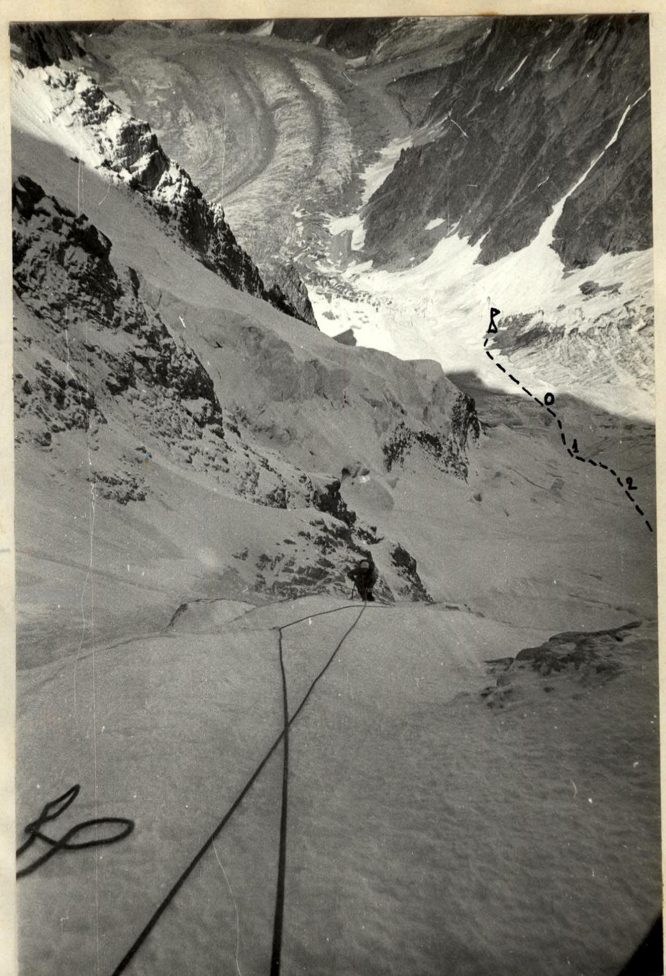
Photo 8. Section R5–R6. Movement along fixed ropes. Taken from point 6 downwards. 10:00.
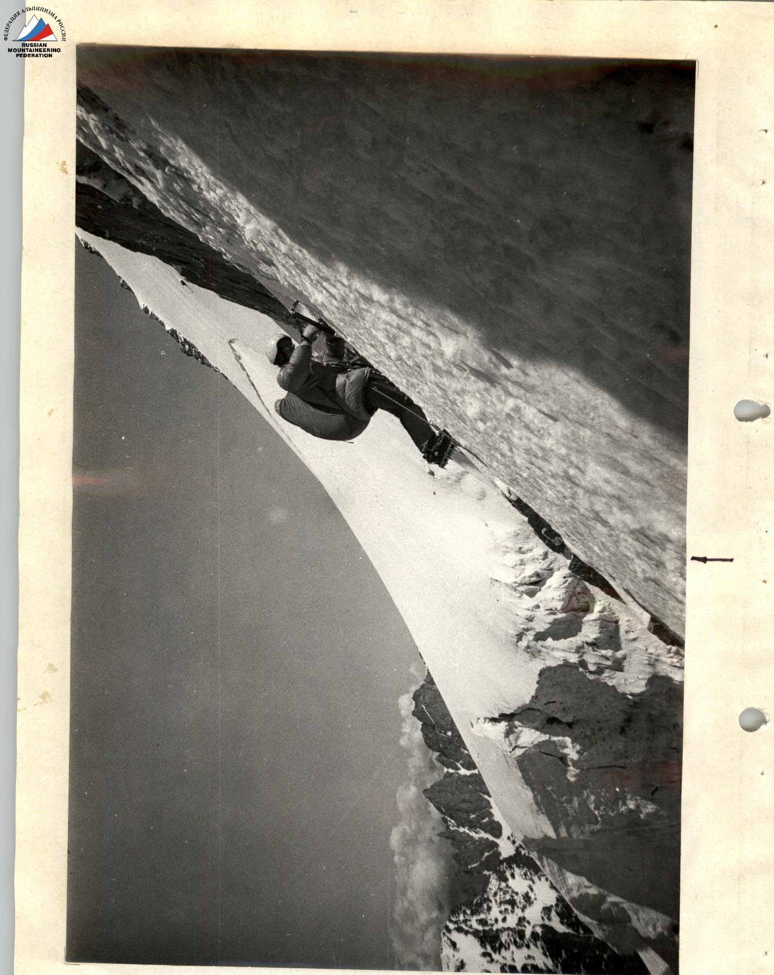
Photo 9. Section R6–R7. On the ice shelf under the "trapeze". 11:40.

Photo 10. Section R6–R7. Exit above the "trapeze". 12:00.
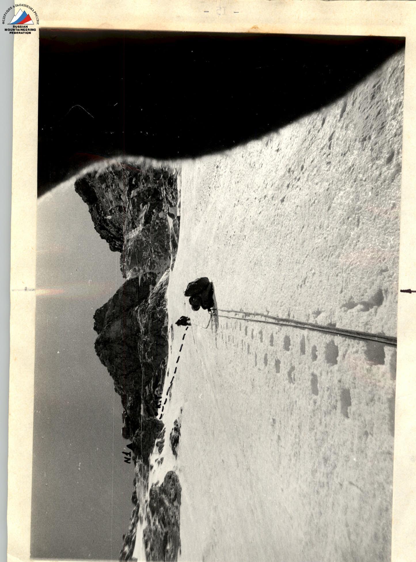
Photo 11. Section R7–R8. Vaguely defined snow-ice ridge. Above it, the 2nd rock belt. 13:00.