Ascent Passport
- Ascent category — ROCK
- Ascent region — CENTRAL CAUCASUS
- Peak, its height, route — MALAYA USHBA, 4200 m, via the SOUTHWEST BUTTRESS, COMBINED
- Estimated category of difficulty — 5B
- Route characteristics: height difference — 700 m route length — 860 m length of sections with 5B–6 category of difficulty — 242 m average steepness of the route — 59°
- Pitons hammered: rock — 46/8 ice — 6 bolt — 2 placed protection — 38/7
- Number of climbing hours — 20
- Number of bivouacs — one, lying down with water.
- Group composition: Kudryavtsev V. A. — CMS, leader Domrachev S. I. — CMS Kruglovenko A. V. — CMS Fursov V. A. — CMS
- Team coach — Kudryavtsev V. A. — CMS, 1st sports category
- Date of departure on the route — August 25, 1985 Summit ascent — August 26, 1985 Return to USAB "Baksan" — August 27, 1985
- Organization — Kursk Regional Sports Committee.
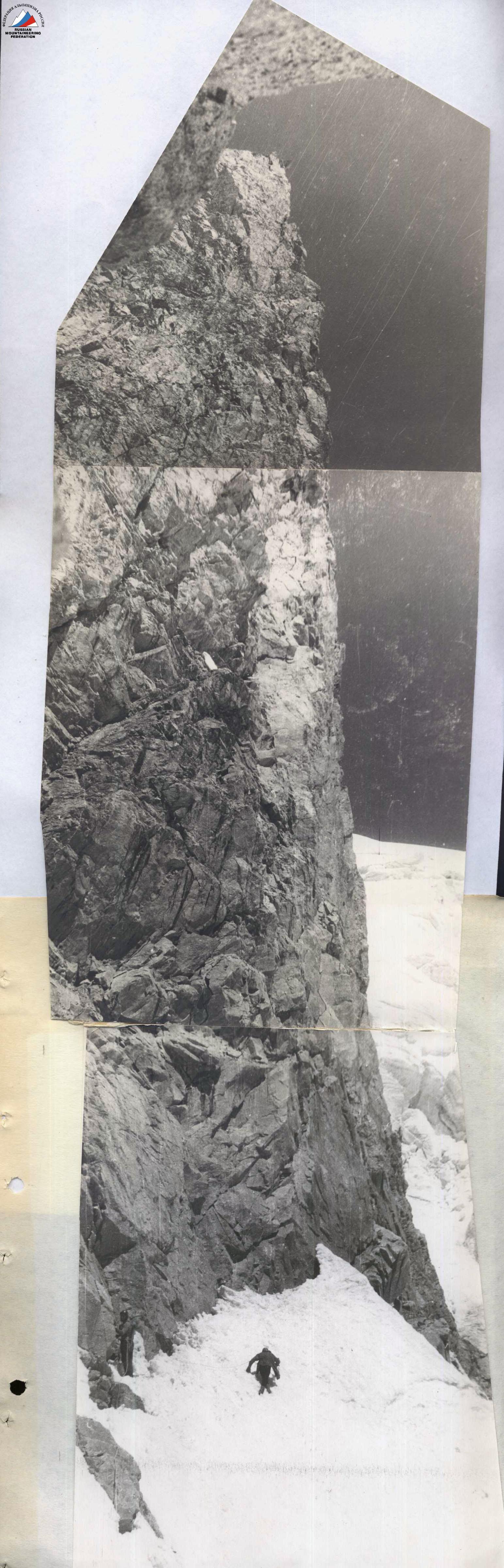
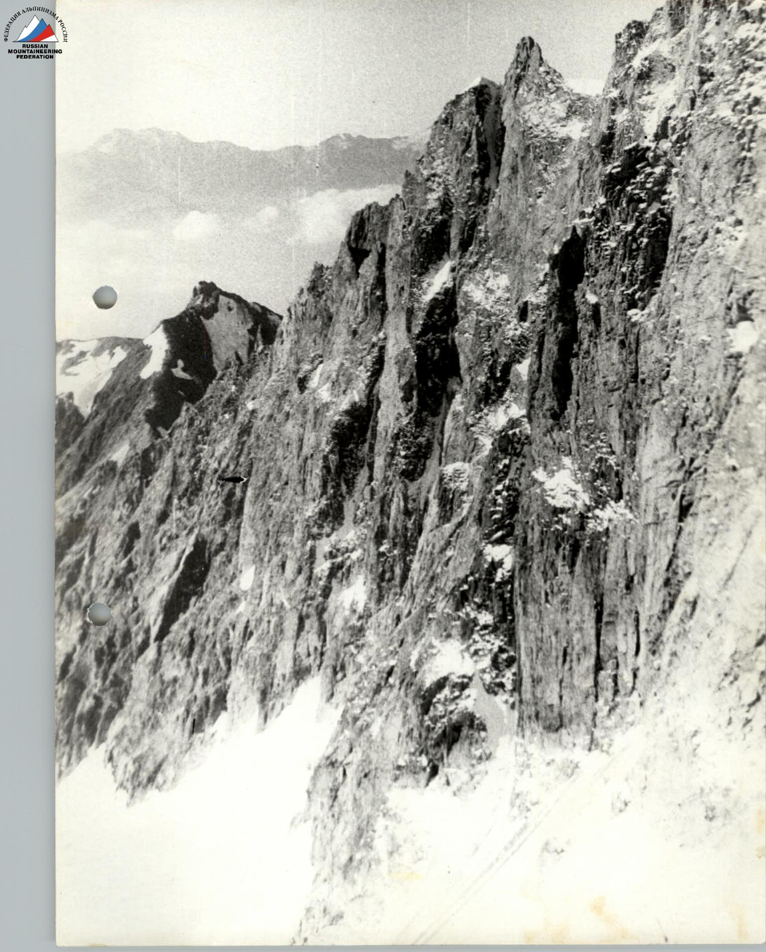
View of the wall from the buttress — observers' bivouac
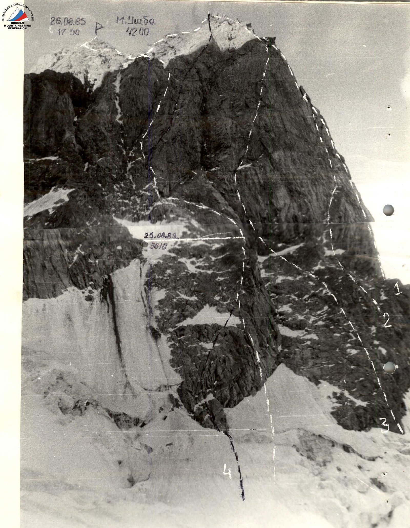
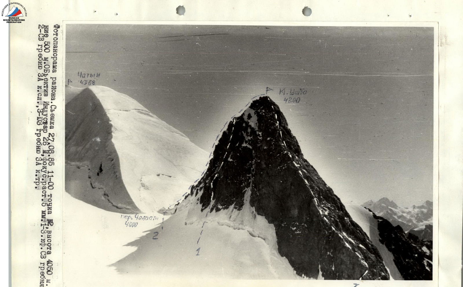
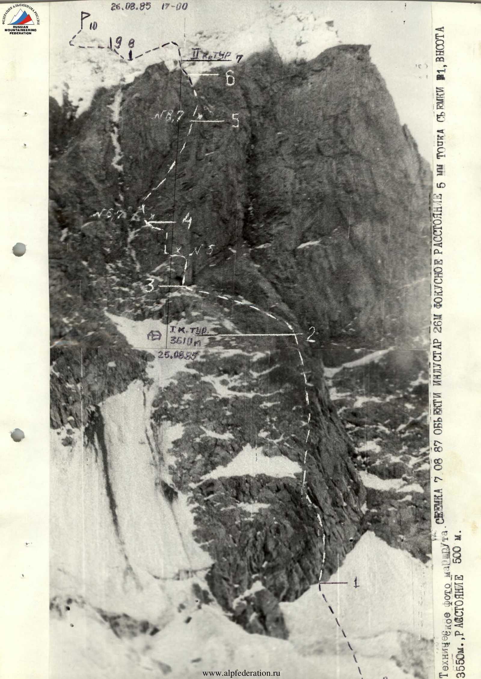
1st Kensitsky 1971, 2nd Gorodetsky 1977, 3rd Grigorenko–Prigoda 1981, 4th group 1985. Shot on August 7, 1985 19:00, Industar-26 M lens, focal length — 5 mm, point # 1, height 3550 m, distances. www.alpfederation.ru↗
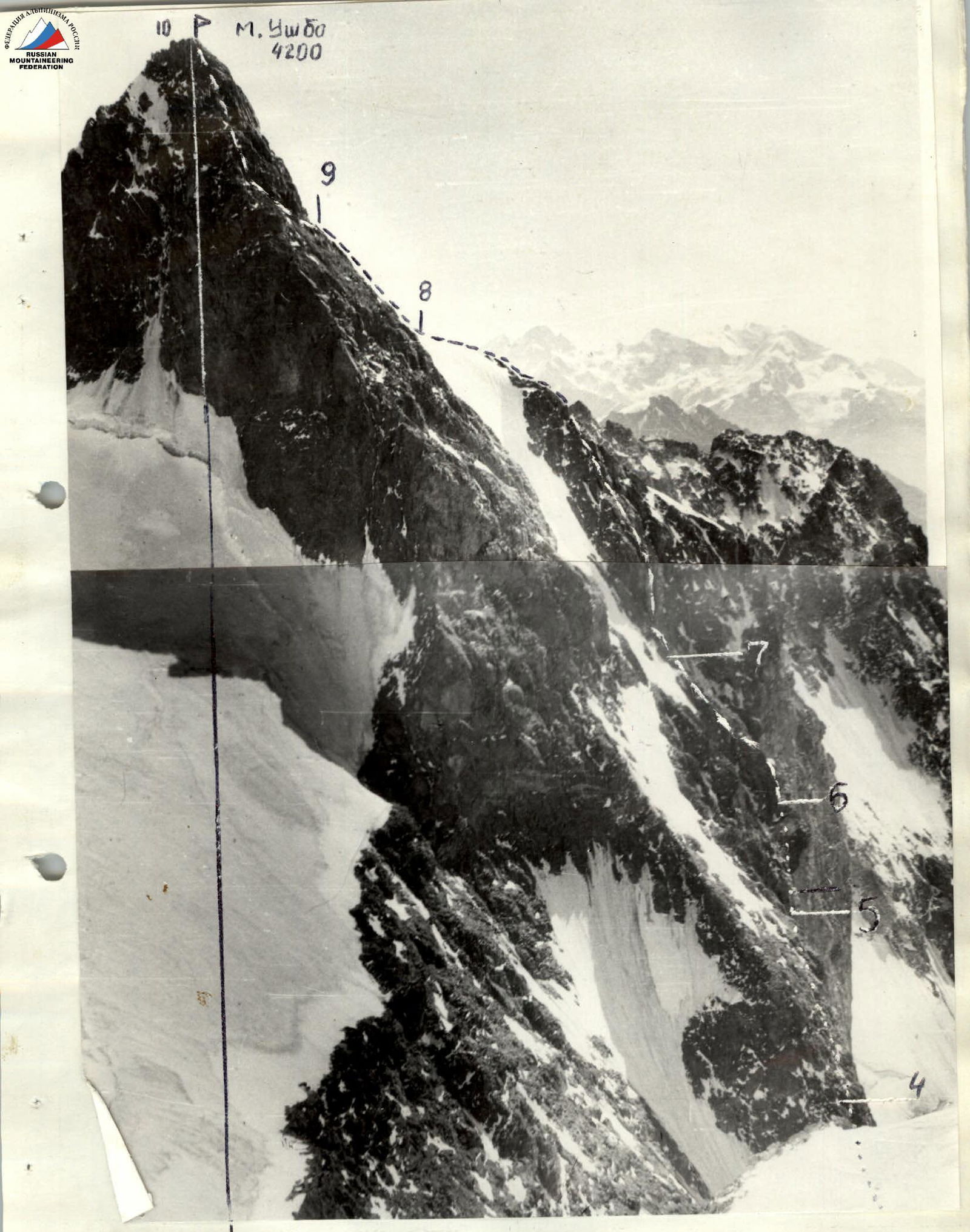
Photo of the wall profile from the left. Shot on August 27, 1985 11:00. Height 4050 m, distance 500 m. Point 2. Industar-26 M lens, focal length 5 mm. ---- visible part of the route,.... invisible part of the route, numbers at the shelves — section numbers according to the UIAA scheme www.alpfederation.ru↗
 The final tactical plan for the ascent was made after a reconnaissance trip to Malaya Ushba on August 5–8, 1985, where the route for the first ascent was finally determined, possible bivouac locations were identified, and the time required to traverse individual sections was estimated.
Visual inspection of key route locations using binoculars determined the selection of equipment:
- shock absorber;
- reusable bolt pitons;
- adjustable placement.
During the ascent, the team followed this movement schedule:
a) departure from the bivouac at 7:00; b) one-hour rest (lunch) 12:00–13:00 (if possible); c) stopping at a bivouac 19:00–20:00 (if possible); d) on the first day of the ascent (August 25, 1985) — wall processing.
The team's communication with the base was carried out through an interaction group located on the Ushba plateau, using a "Karat-2N" radio station.
Taking into account the specific weather conditions in the ascent area, the team had a time reserve (2 days) in case they had to wait out bad weather on the route. Each team member had an individual nutrition kit, a personal first-aid kit that could be used if necessary. In case of a separated night stay, each team member had a bivouac equipment kit: a mat, a bivouac bag, and a down suit.
R0–R1. Ice-snow slope, bergschrund is traversed alternately with the organization of belays on the bergschrund wall and on the slope above the bergschrund. Traversed on August 25, 1985. Cat. diff. II.
R1–R2. Beginning of the buttress up to the bivouac site, rocks 3–5 cat. diff. with good holds in the lower part. When traversing the inner corner, rocks are heavily destroyed, with loose stones present. The section was traversed alternately on a shortened rope. The first rope team was Kudryavtsev–Fursov. In the upper part of the inner corner, rope teams worked in coordination. Traversed on August 25, 1985.
R2–R3. Bivouac on the buttress shoulder (lying down). The location was chosen during reconnaissance, safe in terms of rockfall hazard, with water available (stream — rockfall hazard). From 15:00, the rope team Domrachev–Kruglovenko processed the wall section of the route (by evening, 120 m of belays were set up).
R3–R6. Sheer wall (250 m), rocks 5–6 cat. diff. with overhanging sections, monolithic with a limited number of holds. The first rope team was Domrachev–Kruglovenko. The first climber worked without a backpack using artificial aids. In the middle part of the wall, bolt pitons were hammered for protection. The wall was traversed with rope teams working in coordination and setting up belays. The first climber worked on a double rope, wearing crampons. Belays were mostly traversed with protection. In the morning hours, the wall's lower part had holds covered in ice. Rucksack hauling was not used. The group had three rucksacks (for the duration of the wall traverse). Rucksacks were lifted suspended from the harness.
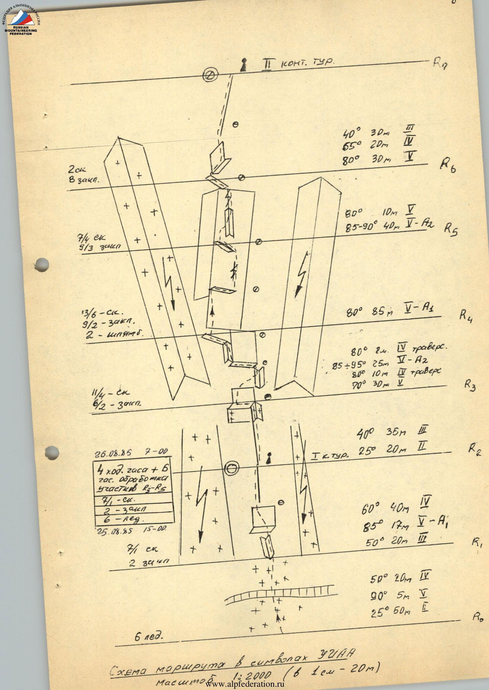
Route diagram in UIAA symbols Scale 1:2000 (1 cm — 20 m)
Route Description by Sections
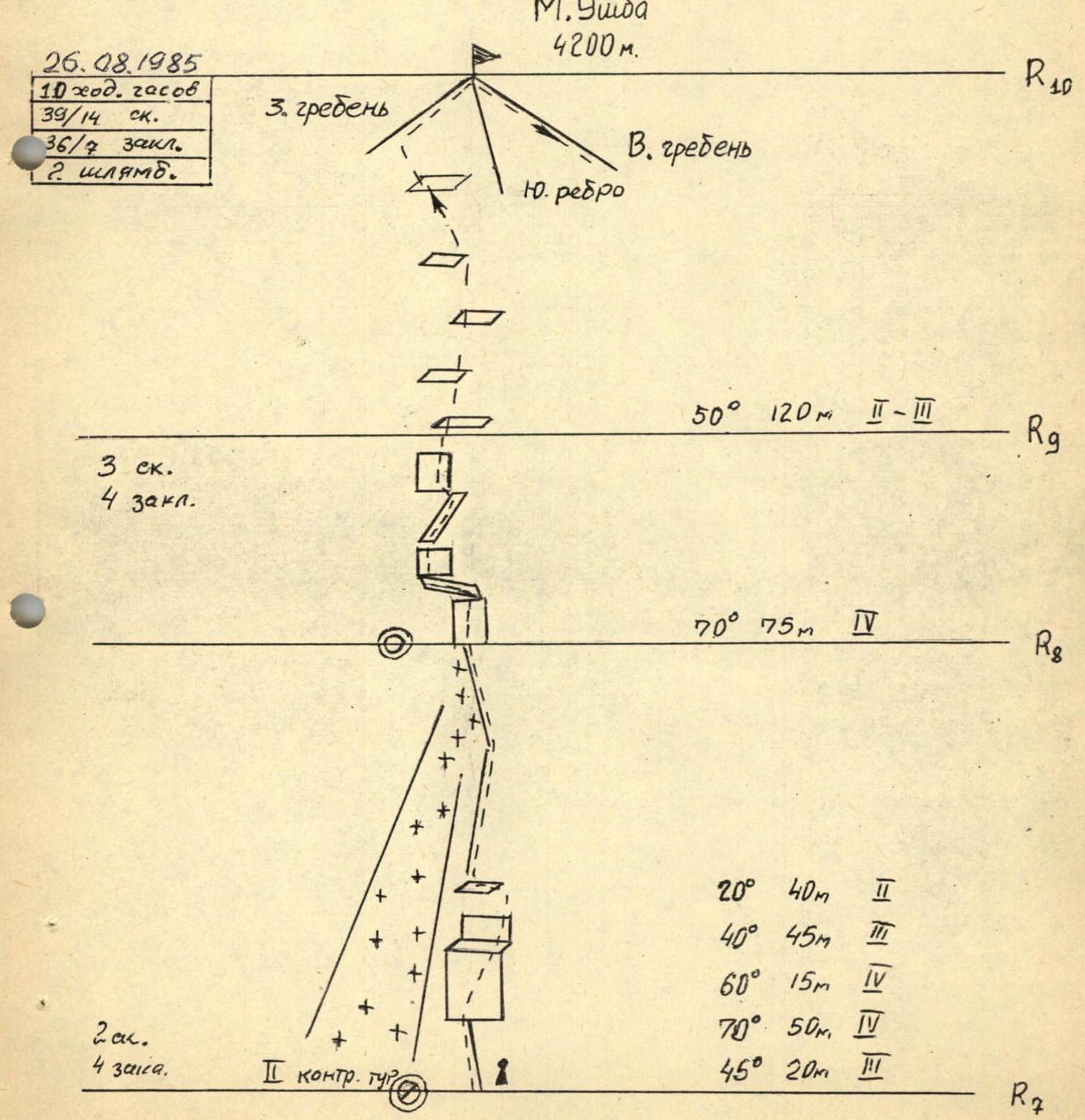
R0–R1. Snow-ice slope with a bergschrund. Up to the bergschrund, the slope is gentle; above it, steep. The bergschrund is filled with snow, the wall height is from 4 to 6 m. R1–R2. Lower part of the buttress. Rocks are mostly monolithic. R2–R3. Destroyed, not very steep, partially snow-covered ridge. On both sides of the ridge, there are rockfall-prone snow-ice couloirs. R3–R6. 250-meter inner corner leaning to the right. The left face of the corner protrudes 6–15 m from the wall and has a steepness of more than 90° along its entire length. The right face, 20–40 m wide, has a steepness of 80–95°, representing a monolithic rock with a limited number of holds and cracks. To the right of this inner corner is a vertical corner-chimney with a small stream. To the left is an inner corner turning into a gap, and then a couloir leading to a snowy ridge on the South ridge of the peak. The corner is covered in ice; after the slopes are illuminated (after 11:00), rocks and ice constantly fall from it. R6–R7. Exit to the buttress shoulder via a destroyed ledge and wall. The buttress shoulder is destroyed, with a steepness of 40° and more. It's possible to set up a tent site. To the left is a steep ice-snow slope; to the right is an icy couloir. On the buttress, there are snow-covered and icy rock sections. R7–R8. Destroyed wall sections of the ridge alternate with convenient belay ledges, most of which are covered in snow and ice. A sharp snowy ridge with small cornices to the east. R8–R9. Monolithic, smooth rocks of the ridge. R9–R10. Destroyed, large-block rocks. Walls are 6–8 m high; ledges are sloping, convenient for setting up belays.