REPORT
On the ascent to the summit of Ushba Mala via the SOUTH face, accomplished from July 23 to 30, 1971, by a team from the "Elbrus" alpine camp in the technically complex ascents category at the USSR Alpine Championship.
Uzhhorod
1971
262.3(18)
1. Team Members' Data
| Full Name | Year of Birth | Nationality | Party Membership | Sports Category | Alpine Experience | Main Profession | Place of Residence |
|---|---|---|---|---|---|---|---|
| Kensitsky Leopold Vsevolodovich | 1926 | Ukrainian | non-party | Master of Sports | 1950 | Mechanical Engineer | Uzhhorod, Petra Velikogo St., 104, apt. 15 |
| Lendel Vasily Vasilyevich | 1944 | Ukrainian | CPSU | Candidate Master | 1962 | Electrician | Uzhhorod, Koshitskaya St. 26/1 |
| Galas Fedor Stepanovich | 1942 | Hungarian | non-party | Candidate Master | 1962 | Electrician | Uzhhorod, Shevchenko St. 9/2 |
| Podgorsky Vasily Mikhailovich | 1944 | Ukrainian | non-party | Candidate Master | 1962 | Electrical Fitter | Uzhhorod, Vysokaya St., 44 |
| Korolev Anatoly Mikhailovich | 1947 | Russian | non-party | Candidate Master | 1963 | Milling Machine Operator | Odessa, Komitetskaya St., 14/15 |
| Lisetsky Vlad. Anatolyevich | 1936 | Ukrainian | CPSU | Candidate Master | 1960 | Upholsterer | Uzhhorod, Shumny Lane, 12/70 |
2. Ascent Route Description
July 23. The team departed from the "Elbrus" alpine camp and by 17:00 stopped at a bivouac at the "Shkheldinsky overnight stays".
July 24. Departure at 6:00, ascent via the Ushba glacier. Overnight stay on the Ushba plateau between the North and Mala Ushba peaks.
July 25. Departure at 5:00, descent to the Chalaat glacier using ropes hung by the CS "AVANGARD" group (for which they are very grateful) and by 9:00, the team, bypassing the counterfort of Mala Ushba, began ascending snow in the direction of the middle of the rock part of the route from the upper plateau of the Chalaat glacier. (A bivouac for observers was set up on the rocks of the counterfort to the left of the route). By 10:30, ascending snow that became steeper in the upper part, they approached the rocks at the bottom of the wall. The rocks are steep, heavily fractured, and dangerous. After ascending 30 m with piton protection, they reached a more gentle section with ledges suitable for setting up platforms after some additional preparation. Immediately above the ledges, a sheer wall begins. The wall's rocks are heavily dissected by vertical cracks. The ascent appears visually not difficult. At 12:00, the team started setting up a bivouac for two tents. A pair went on reconnaissance and processing the sheer section. By 19:00, the pair returned after processing 80 m of the route. It was found that the rocks on the route are very complex, and it's impossible to climb with backpacks. There is no relatively easy path; many sections are overhanging.
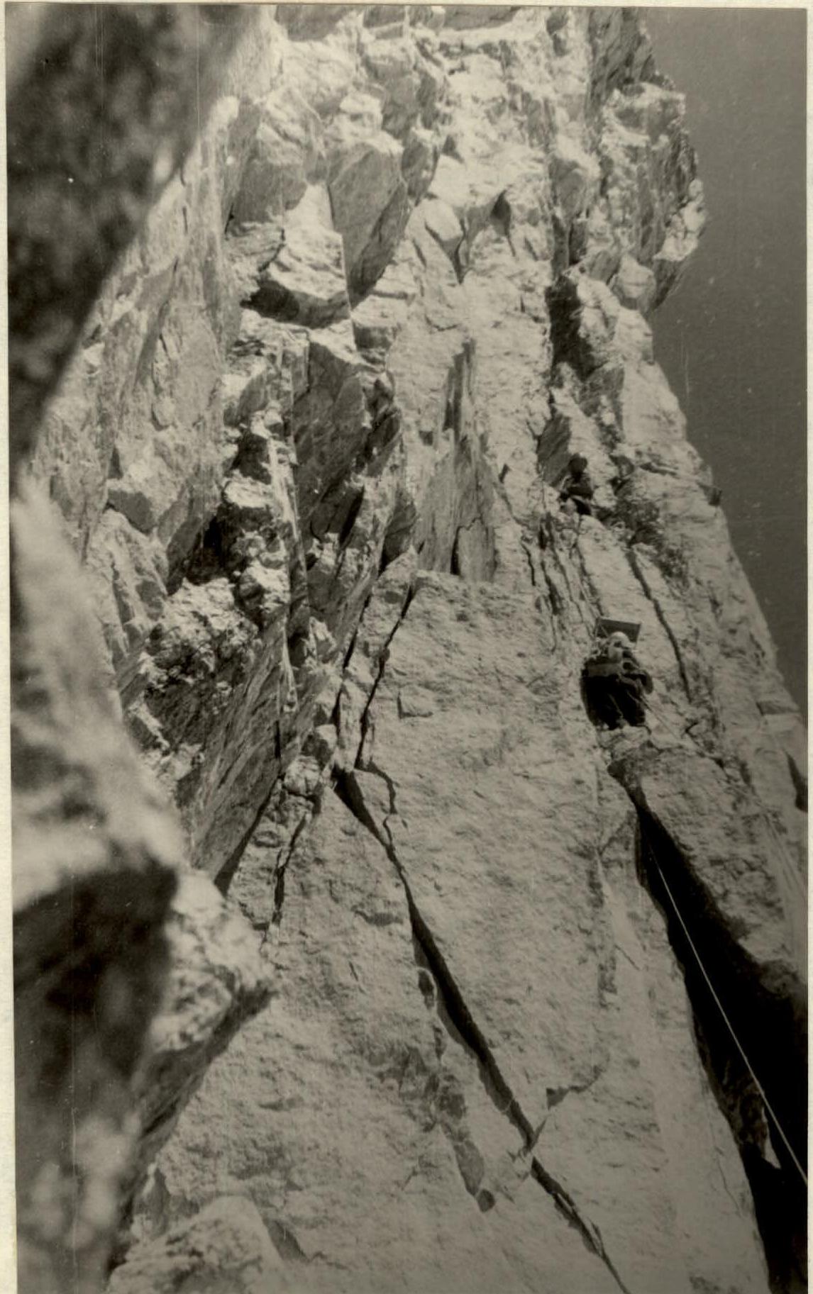
July 26. Departure at 7:00. Initially, they ascended easy rocks from the right-hand platform straight up and immediately encountered a 10 m wall with vertical cracks and few holds. At the top of the wall, there's a wet, steep, inclined ledge, and above it, an overhang. Along the ledge, 5 m to the right and upwards, there's a very difficult passage around a vertical protrusion. Further on, the ledge becomes wide and gentle. After passing the protrusion, 10–15 m of ascent directly upwards along a not clearly defined inner corner with fractured rocks at an 85° angle leads to an inner corner with smooth walls at a 90° angle. Climbing is very complex. At the top of the corner, there's a protrusion where 2 people can stand. Above the corner, there's an overhang (point 8 on the profile scheme). The overhanging part is traversed along the wall to the right with extremely complex climbing and then straight up with minor deviations to the right and left, 30 m of extremely complex climbing. A small ledge-protrusion. A 60 m rope is used to pull up backpacks. From the ledge (point 9 on the scheme), movement is to the left, bypassing the overhang along a flake, and then straight up to a smooth overhanging part — extremely difficult climbing. The overhanging section is traversed using pitons and ledges. A decision is made to set up for the night. Time is 16:00. The pair continues working, moving upwards. The rest began setting up the bivouac. The first pair passed another 40 m of the sheer section by 19:00 and was joined by one person with water. The remaining three people spent the night on lower protrusions. The day was very challenging. There's absolutely no water on the wall. It's very hot. After 15–20 minutes of work on the route, the mouth dries out, and the throat becomes parched. It's not cold at night, the weather is good, but there's a strong desire to drink.
July 27. Departure at 7:00. The thought of the snow seen higher during observations of the wall from v. Chatyn motivates them forward. From the bivouac, it's visible that the wall is overhanging. 5 m are climbed. Further on, there's a smooth vertical slab with overhangs. 10 m of the slab are traversed with the aid of pitons and ledges. Above the slab, sheer, fractured, and partly overhanging rocks are climbed. Rest is only possible on a piton with a chest harness. Above small protrusions, there's usually an overhang. Another rope is traversed with a slight traverse to the left at the beginning and then straight up with extremely difficult climbing, and the steepness finally decreases on the 20th meter of the next rope. Another 20 m of ascent to the left and upwards along an inner corner, and there's a place for pulling up backpacks. From this part of the route, the overhanging upper right part of the wall is visible. To the right, 35–40 m from the route, a stream of water flows down, dispersing in the air. Sometimes the wind brings it to them, but it's not enough to drink; it only refreshes. Further ascent is along an inner corner with an 80–85° angle to a wide, steep ledge. Along the ledge, there's a 12 m traverse to the left, a 2 m descent, and an ascent along a vertical crack to a large protrusion with an inner corner filled with ice. The protrusion lies on an indistinct edge of the wall. On the protrusion, a platform sized 1.5 × 3.5 m is constructed by the team. On the platform, a control cairn is built.
July 28. The team tidies up their equipment. A pair processes 80 m of the upper third of the sheer part of the wall.
July 29. Departure at 7:00. Ascent upwards along a vertical crack to a ledge on the right side of the corner and further along two flaked slabs into an inner corner (vertical). Along the corner, extremely complex climbing leads straight up under an overhang. A total of 60 m from the bivouac. To the left of the overhanging part, there's a smooth wall with a minimal number of holds. Above, there are no holds, and the last 25 m of the sheer section are traversed using ledges:
- first on pitons (8 pieces)
- then on regular pitons.
Above the sheer section, there's a good, large ledge. Along fractured rocks, there's an ascent to the right and left upwards, 20 m, and a traverse to the left — very complex, with a passage around an overhang. A ledge. Further upwards, first to the right and then to the left — an exit along rocks to the top of the wall. Along a rocky-snowy ridge — to the summit tower. The tower is bypassed on the right along a ledge with an exit to the summit ridge. The path from the top of the wall is not difficult. Descent from the summit is via the 2B category route. At 15:00, the group was on the summit. By 17:00, they descended to the Ushba plateau.
July 30. The team in full, with observers, descended the glacier and by 16:00 returned to the "Elbrus" alpine camp.
Section R18–R19–R20.
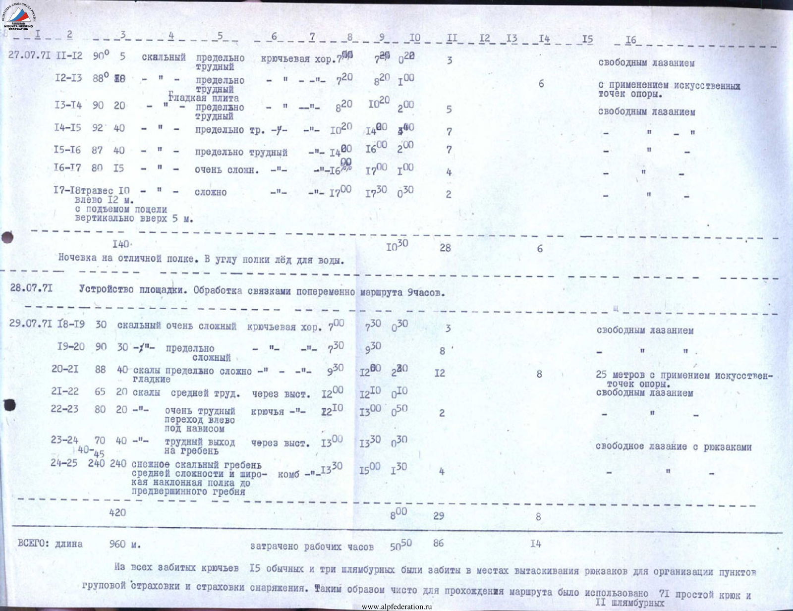
3. Table of Main Characteristics of the Ascent Route
Appendix to the Profile Scheme TABLE of main characteristics of the ascent route
Ascent Route Including the most complex sections Height difference of the route Steepness of the route Including the most complex sections
| Date | Section | Steepness | Height Difference | Route Character | Complexity Category | Belay Technique | Length, m | Time, h | Notes |
|---|---|---|---|---|---|---|---|---|---|
| July 25, 1971 | R0–R1 | 45–50° | 200 | snow | medium difficulty | via ice axe | 200 | 1:30 | |
| R1–R2 | 70° | 30 | rock | difficult | pitons | 70 | 0:30 | ||
| R2–R3 | 45° | 10 | rock | easy | 45 | 0:20 | |||
| 240 | 240 | ||||||||
| Setting up bivouac, observing the wall, processing the route 80 m | 80 | 3:00 | |||||||
| July 26, 1971 | R3–R4 | 30° | 10 | rock | easy | good | 10 | 0:10 | free climbing without backpacks |
| R4–R5 | 88° | 10 | rock | very difficult | pitons | 10 | 0:20 | ||
| R5–R6 | traverse along a ledge with passage around an overhang. To the right 20 m | 5 | rock | difficult | pitons | 5 | 0:40 | via fixed ropes | |
| R6–R7 | 85° | 20 | difficult | pitons | 20 | 1:00 | Starting from R6–R7 to section R23, the group ascended with the pulling up of backpacks, i.e., all team members went without backpacks. | ||
| R7–R8 | 90° | 5 | extremely complex | pitons | 5 | 1:00 | |||
| R8–R9 | 90–92° | 30 | extremely complex | pitons | 30 | 3:00 | |||
| R9–R10 | 90° | 40 | extremely complex with passage around an overhang to the left | 40 | 4:10 | ||||
| R10–R11 | 89° | 40 | extremely | pitons | 40 | 2:30 | 10 m using artificial holds. | ||
| R11–R12 | free climbing |
Sitting overnight on inclined protrusions at points marked on the profile scheme. In various locations.
| Date | Section | Steepness | Height Difference | Route Character | Complexity Category | Belay Technique | Length, m | Time, h | Notes |
|---|---|---|---|---|---|---|---|---|---|
| July 27, 1971 | R11–R12 | 90° | 5 | rock | extremely difficult | piton | 5 | 0:20 | free climbing |
| R12–R13 | 88° | 10 | extremely difficult | 10 | 1:00 | using artificial holds. | |||
| R13–R14 | 90° | 20 | smooth slab | extremely difficult | 20 | 2:00 | free climbing | ||
| R14–R15 | 92° | 40 | extremely difficult | 40 | 3:00 | ||||
| R15–R16 | 87° | 40 | extremely difficult | 40 | 2:00 | ||||
| R16–R17 | 80° | 15 | very complex | 15 | 1:00 | ||||
| R17–R18 | traverse 10 m to the left 12 m with ascent along a crack vertically upwards 5 m | 140 | complex | 140 | 0:30 | ||||
| Overnight on an excellent ledge. Ice for water in the corner of the ledge. | |||||||||
| July 28, 1971 | Setting up a platform. Processing the route alternately by pairs for 9 hours. | 9:00 | |||||||
| July 29, 1971 | R18–R19 | 30° | rock | very complex | piton | 30 | 0:30 | free climbing | |
| R19–R20 | 90° | 30 | extremely complex | 30 | 3:00 | ||||
| R20–R21 | 88° | 40 | smooth rocks | extremely complex | 40 | 2:80 | 25 m using artificial holds. | ||
| R21–R22 | 65° | 20 | rocks | medium difficulty | via a protrusion | 20 | 0:10 | free climbing | |
| R22–R23 | 80° | 20 | very difficult passage to the left under an overhang | pitons | 20 | 0:50 | |||
| R23–R24 | 70° | 40 | difficult exit to the ridge | via a protrusion | 40 | 0:30 | free climbing with backpacks | ||
| R24–R25 | 240 | 240 | snow-rock ridge | medium complexity and wide inclined ledge to the pre-summit ridge | combined | 240 | 1:30 |
TOTAL: length 960 m. Total working hours: 50 h 50 min (86 h 14 min). Out of all the pitons driven, 15 regular and three pitons were used for pulling up backpacks to organize group belay points and equipment belay. Thus, purely for the route passage, 71 regular pitons and 11 pitons were used.