ASCENT RECORD
- Climbing category — ice and snow.
- Climbing area — Central Caucasus.
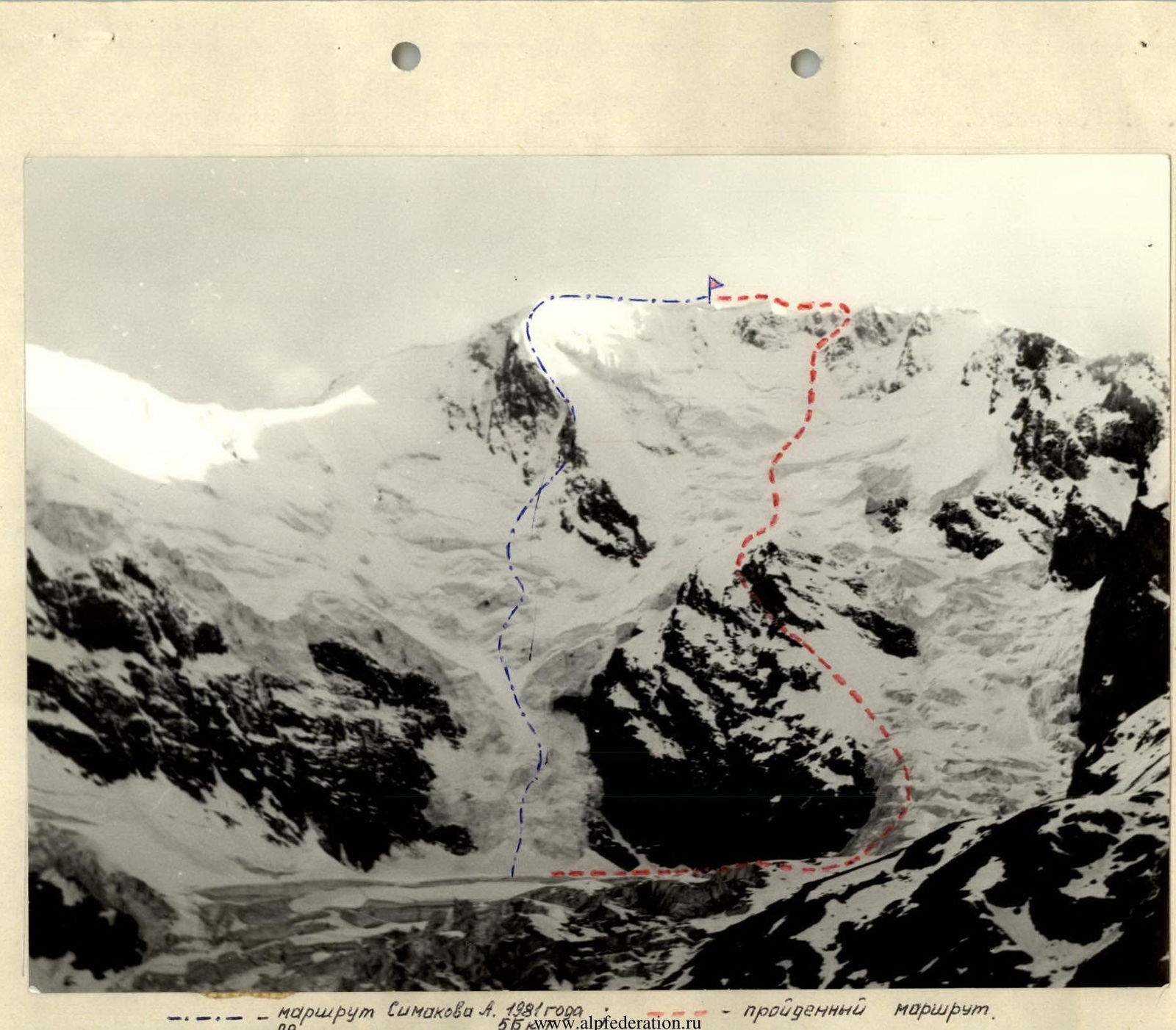
- Peak Ullu-Kara, 4302 m, via the right part of the north-eastern wall, ice and snow route.
- Proposed difficulty category 5B.
- Route characteristics: height difference 1300 m, length of sections with 5–6 category difficulty — 170 m, average steepness 47°.
- Pitons used: rock — 13, ice screws — 60, protection gear — not used.
- Total climbing hours — 19.
- Number and nature of bivouacs: one, lying down.
- Full name of the leader, participants, and their qualifications: Simakov Anatoly Nikolayevich — Master of Sports of the USSR Shalaev Andrey Nikolayevich — Candidate for Master of Sports Danilina Marina Evgenievna — Candidate for Master of Sports
- Team coach — Simakov A.N.
- Date of departure and return: Departure on March 11, 1986 Summit on March 12, 1986 Return on March 12, 1986
- Organization: Sports Committee of Moscow
Brief description of the approach to the route
From the "Dzhangutan" tourist center along the trail to the "Green Hotel". Then cross the Bashkara glacier and approach the lower icefall of the NE wall glacier of Ullu-Kara peak. Two approach options are possible from here:
- 1st option — left through the icefall (the group took this route);
- 2nd option — right of the icefall via the "sheep's foreheads", which are snow-covered in winter.
The initial bivouac is located here.
Brief description of the route
From the initial bivouac, depart at night, crossing the glacier to the plateau under the rock island. Along a snowy slope with a 30° steepness, approach the right branch of the icefall descending from the northern slope of Ullu-Kara. Then, along a steep icy slope, bypassing the rock island to the right, ascend 160 m and move onto the "sheep's foreheads" of the right rock slope of the rock island. Ascend 240 m up and to the left into a wide, steep 60° ice couloir. From it, exit onto the ridge of the central buttress of the rock island. Then move 10 m to the right and traverse 80 m to the left along a narrow shelf of the randkluft (a safe bivouac is possible) under overhanging rocks (there is a control cairn here) to exit into a snow-ice couloir leading to the summit of the rock island. Cross the plateau and ascend along the right side of a steep avalanche cone into a steep snow-ice couloir, transitioning into a steep ice gorge. Exit it to the right into a bergschrund. Then ascend directly up a snow-ice slope. Exit onto a steep 65° ice wall, ascend it to the right — exit into a couloir descending from the NW ridge of the peak. Ascend the steep couloir (bergschrund) onto the ridge (cornice). Bivouac here. Then ascend 120 m along a gentle ice slope onto the summit dome of Ullu-Kara.
Descent via a category 3A route.
Route diagram
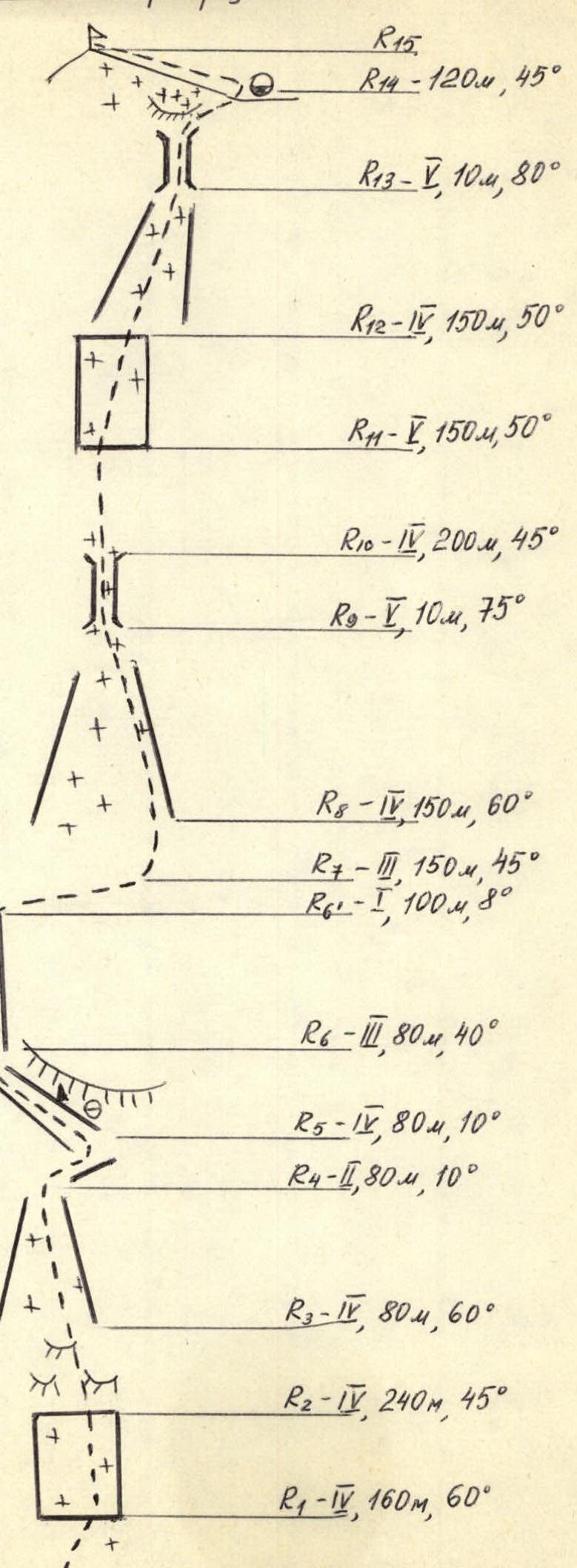 — route by Simakov A., 1981 — route taken.
R15 R14 — 120 m, 45° R13 — 3, 10 m, 80° R12 — 4, 150 m, 50° R11 — 4, 150 m, 50° R10 — 4, 200 m, 45° R9 — 1, 10 m, 75° R8 — 4, 150 m, 60° R7 — 3, 150 m, 45° R6' — 1, 100 m, 8° R6 — 3, 80 m, 40° R5 — 1, 80 m, 10° R4 — 2, 80 m, 10° R3 — 4, 80 m, 60° R2 — 4, 240 m, 45° R1 — 4, 160 m, 60° R0 — 1, 250 m, 30°
| Section numbers | Terrain | Steepness | Length | Movement | Equipment used |
|---|---|---|---|---|---|
| R0–R1 | Snow | 30° | 250 m | simultaneous | – |
| R1–R2 | Snow+ice | 60° | 160 m | simultaneous | 10 ice screws |
| R2–R3 | Rocks («sheep's foreheads») | 45° | 240 m | alternating | 8 rock pitons, 6 ice screws |
| R3–R4 | Snow+ice | 60° | 80 m | simultaneous | 4 ice screws |
| R4–R5 | Rocks | 10° | 10 m | simultaneous | – |
| R5–R6 | Snow+rocks | 10° | 80 m | alternating | 5 rock pitons, 2 ice screws |
| R6–R6' | Snow+ice | 45° | 80 m | simultaneous | 4 ice screws |
| R6'–R7 | Snow | 8° | 100 m | simultaneous | – |
| R7–R8 | Snow | 45° | 150 m | simultaneous | – |
| R8–R9 | Snow+ice | 60° | 150 m | simultaneous | 6 ice screws |
| R9–R10 | Ice | 75° | 10 m | alternating | 3 ice screws |
| R10–R11 | Snow | 45° | 150 m | simultaneous | – |
| R11–R12 | Ice | 65° | 150 m | alternating | 12 ice screws |
| R12–R13 | Snow+ice | 50° | 150 m | alternating | 10 ice screws |
| R13–R14 | Ice+snow | 80° | 20 m | alternating | 3 ice screws |
| R14–R15 | Ice | 40° | 120 m | simultaneous | – |