Ascent Passport
- Ascent category
- technical
- Ascent area
- Caucasus, from Chipperazau pass to Kitlod pass
- Peak
- Kyukyurtlyu 4639 m, center of the western wall
- Proposed category difficulty
- 6B
- Route characteristics
- combined
- Route characteristics:
- elevation gain — 1039 m
- length of 5B sections — 220 m
- length of 6B sections — 260 m
- length of sections using artificial climbing aids (ITOs) — 65 m
- average slope — 52°
- average slope of the wall section (560 m) — 83°
- Number of anchors for belaying:
- rock anchors — 51
- ice anchors — 3
- bolt anchors — 2
- chocks — 105 for creating ITOs:
- rock anchors — 5
- bolt anchors — 14
- chocks — 48
- Total climbing time — 45 hours
- Overnight stops
- 6 sitting bivouacs
- Team composition:
- Viktor Boyko — Candidate Master of Sports, captain
- Georgy Abarbarchuk — Candidate Master of Sports
- Sergey Dudnikov — Candidate Master of Sports
- Vasily Krivov — Candidate Master of Sports
- Vladimir Chumak — 1st sports category
- Team coach — Fedor Pogosyan — Master of Sports of the USSR
- Date of departure on the route — June 29, 1982
- Date of return — July 5, 1982

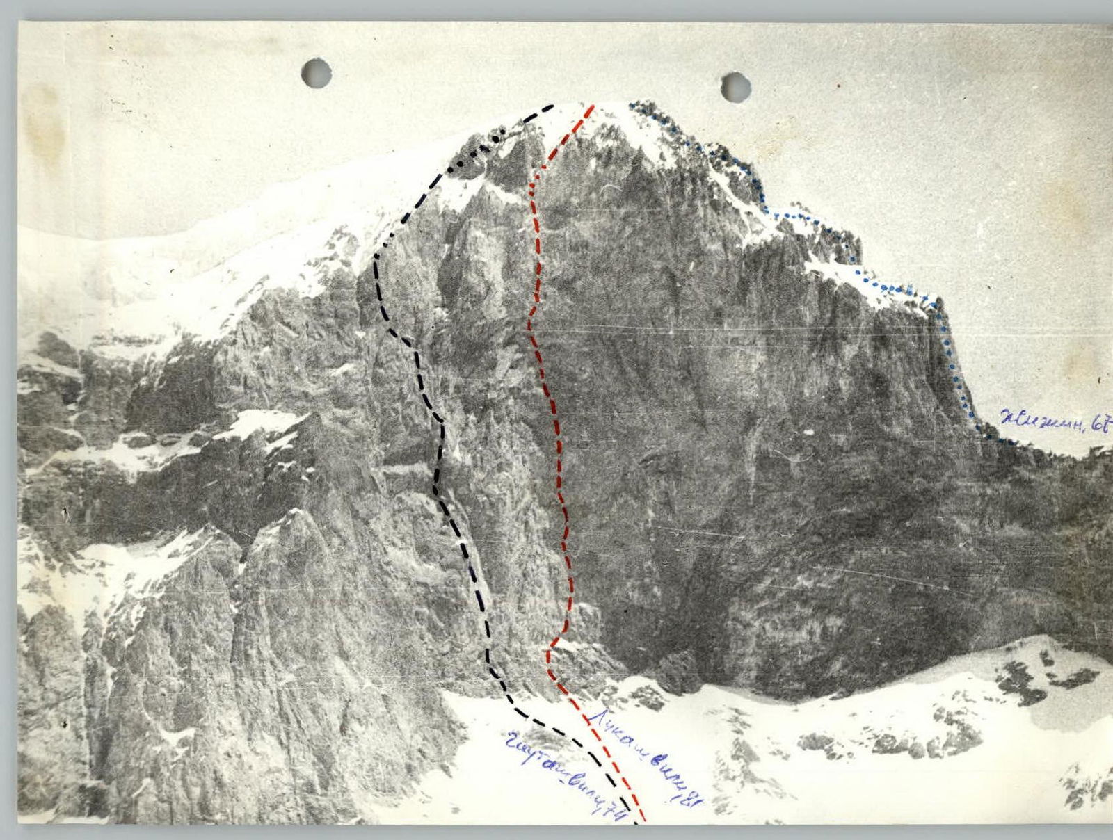
Crescent, 68 The route through the center of the western wall of Kyukyurtlyu peak was climbed by a team from the North Caucasus Military District as part of the 1982 championship of the Soviet Army and Navy.
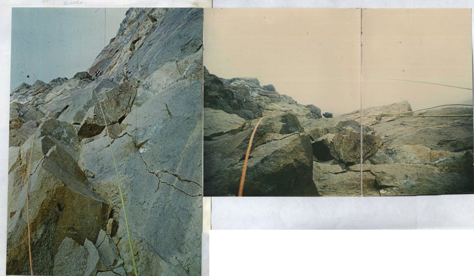
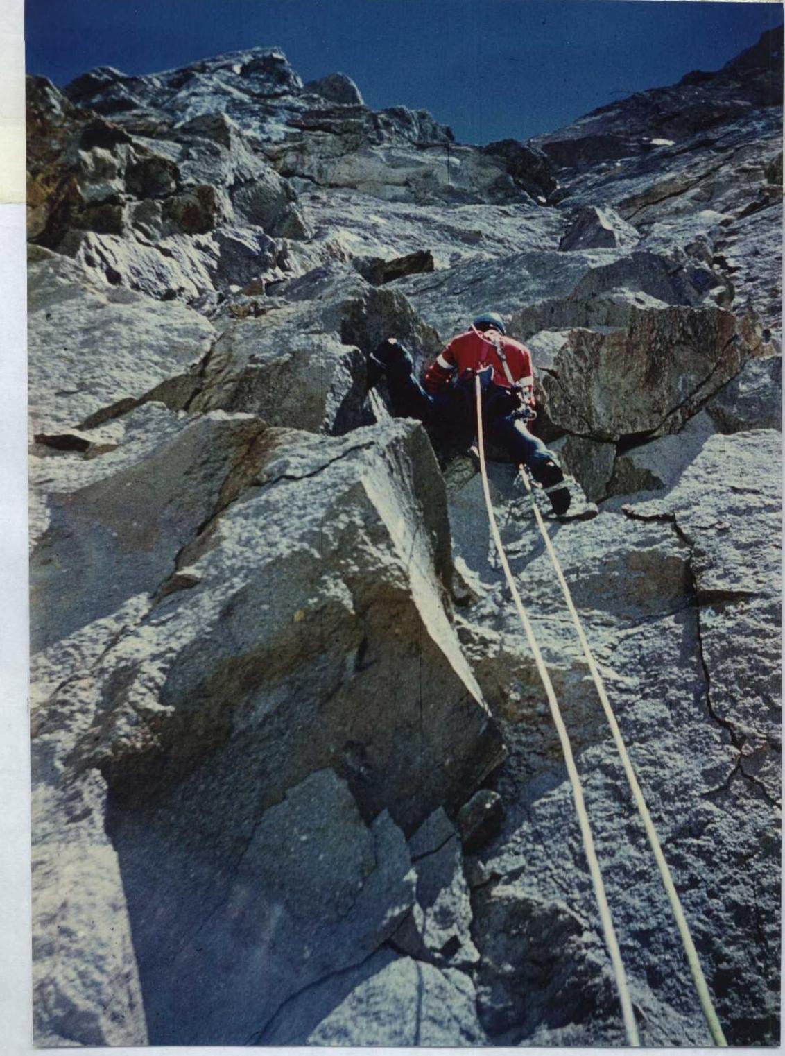
The Kyukyurtlyu area is known for its highly unpredictable weather. The western wall of Kyukyurtlyu is particularly harsh. Its black sheer face is lit by the sun only from 14:00 to 15:00, while the "roof" of the wall is illuminated for most of the day. This makes work difficult in the morning hours, and the lower part of the route (sections R0–R14) is prone to rockfall from 11:00.
There are no convenient places for overnight stops, and prolonged "sitting" on the wall is practically impossible. There are also no convenient belay stances, except for the section R13–R14, where belaying is done while sitting in a "harness".
The difficulties faced by climbers on this route:
- bad weather
- lack of conditions for rest
- long sections with negative incline and cornices
- lack of water and snow on the wall section of the route
- unstable rock
- cold
place the western wall of Kyukyurtlyu among the most challenging wall routes in the Caucasus. In this regard, it is surprising that Georgian climbers (T. Lukashvili, 1981, "Gruzsportkomitet", silver medals at the USSR championship) sought to "intimidate" and "complicate" the already sufficiently difficult and harsh wall with exaggerations. For example, the route length was almost doubled, and the steepness and difficulty of individual sections were overstated. Such dishonesty has unfairly tarnished (and entirely undeservedly) the interesting and challenging, truly majestic western wall of Kyukyurtlyu.
Previous routes climbed by the team members, such as 6B category routes like Chatyn Gl. via the N. wall, B. Nakhar via the N-W wall, and control-ascent routes of 5B category like Dolar via the W wall of the bastion, Domбай Gl. via the N-W wall (Gubanov's route), are inferior to the center of the western wall of Kyukyurtlyu. The overall length of the "sixes" on Chatyn and Nakhar is also inferior. All the mentioned routes are inferior in terms of the length of overhanging sections, average steepness of the wall section, and psychological tension. This justifies evaluating the route through the center of the western wall of Kyukyurtlyu peak as a 6B category route, following the first ascensionists.
Table of main characteristics of the ascent route to Kyukyurtlyu 4639 m via the center of the western wall
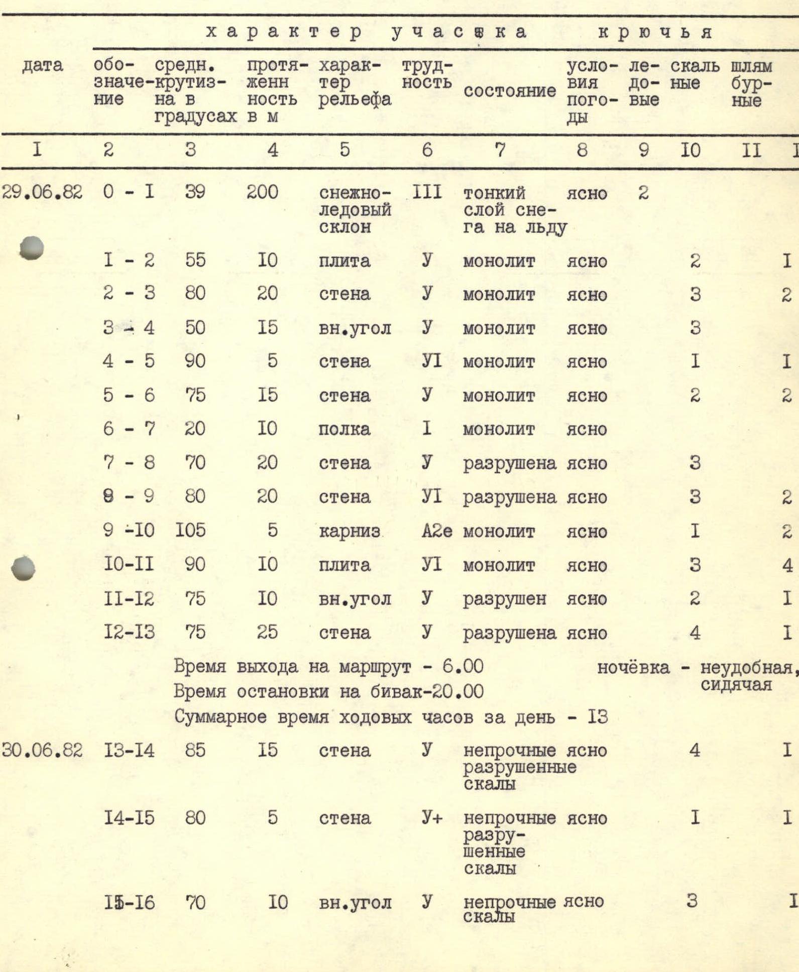
| Date | Section | Average slope in degrees | Length in m | Terrain characteristics | Difficulty (of the section) | Condition | Weather conditions | Ice anchors | Rock anchors | Bolt anchors | Additional info |
|---|---|---|---|---|---|---|---|---|---|---|---|
| 29.06.1982 | R0–R1 | 39 | 200 | snow-ice slope | 3 | thin layer of snow on ice | clear | 2 | |||
| R1–R2 | 55 | 10 | slab | 5 | monolith | clear | 2 | 1 | |||
| R2–R3 | 80 | 20 | wall | 5 | monolith | clear | 3 | 2 | |||
| R3–R4 | 50 | 15 | inner corner | 5 | monolith | clear | 3 | ||||
| R4–R5 | 90 | 5 | wall | 6 | monolith | clear | 1 | 1 | |||
| R5–R6 | 75 | 15 | wall | 5 | monolith | clear | 2 | 2 | |||
| R6–R7 | 20 | 10 | ledge | 1 | monolith | clear | |||||
| R7–R8 | 70 | 20 | wall | 5 | destroyed | clear | 3 | ||||
| R8–R9 | 80 | 20 | wall | 6 | destroyed | clear | 3 | 2 | |||
| R9–R10 | 105 | 5 | cornice | А2e | monolith | clear | 1 | 2 | |||
| R10–R11 | 90 | 10 | slab | 6 | monolith | clear | 3 | 4 | |||
| R11–R12 | 75 | 10 | inner corner | 5 | destroyed | clear | 2 | 1 | |||
| R12–R13 | 75 | 25 | wall | 5 | destroyed | clear | 4 | 1 | |||
| Departure time on the route — 6:00 | |||||||||||
| Time of stopping at a bivouac — 20:00 | |||||||||||
| Total climbing time for the day — 13 hours | |||||||||||
| Overnight stop — uncomfortable, sitting | |||||||||||
| 30.06.1982 | R13–R14 | 85 | 15 | wall | 5 | unstable, destroyed rocks | clear | 4 | 1 | ||
| R14–R15 | 80 | 5 | wall | 5 | unstable, destroyed rocks | clear | 1 | 1 | |||
| R15–R16 | 70 | 10 | inner corner | 5 | unstable rocks | clear | 3 | 1 | |||
| R16–R17 | 75 | 25 | wall | 5 | destroyed, unstable rocks | clear | 2 | 4 | |||
| R17–R18 | 100 | 5 | wall | 6 | unstable rocks | clear | 2 | ||||
| R18–R19 | 90 | 25 | wall | 6 | unstable rocks | clear | 3 | 7 | |||
| R19–R20 | 100 | 10 | chimney | 6 | fractured rocks | clear | 1 | 3 | |||
| R20–R21 | 100 | 10 | cornice | А2e | monolith | clear | 3 | 4 | 4 | ||
| R21–R22 | 100 | 10 | slab | А2e | monolith | clear | 3 | 2 | 5 | ||
| R22–R23 | 90 | 10 | wall | 6 | unstable rocks | clear | 4 | ||||
| Departure time on the route — 8:00 | |||||||||||
| Time of stopping at a bivouac — 20:00 | |||||||||||
| Total climbing time — 11 hours | |||||||||||
| Overnight stop — comfortable, sitting | |||||||||||
| 01.07.1982 | R23–R24 | 90 | 15 | slab | А2e | monolith | clear | 2 | 3 | 11 | |
| R24–R25 | 80 | 35 | wall | 5 | destroyed, unstable rocks | clear | 11 | ||||
| R25–R26 | 90 | 30 | wall | 6 | fractured, unstable rocks | good | 10 | ||||
| R26–R27 | 90 | 15 | chimney | 5 | monolith | good | 4 | ||||
| R27–R28 | 50 | 5 | wall | 4 | destroyed rocks | good | 1 | ||||
| R28–R29 | 95 | 5 | cornice | 6 | monolith | good | 2 | ||||
| R29–R30 | 90 | 20 | inner corner | 6 | fractured, unstable rocks | good | 1 | 7 | |||
| R30–R31 | 90 | 5 | wall | 6 | monolith | good | 2 | ||||
| R31–R32 | 105 | 5 | cornice | А2e | monolith | good | 3 | 2 | |||
| R32–R33 | 100 | 5 | slab | 6 | monolith | fog | 2 | ||||
| R33–R34 | 90 | 10 | cornice | А2e | fractured, unstable rocks | fog | 1 | 2 | 11 | ||
| R34–R35 | 90 | 10 | wall | 6 | unstable rocks | fog | 4 | ||||
| R35–R36 | 100 | 10 | series of cornices | 6 | monolith | fog | 1 | 3 | |||
| R36–R37 | 90 | 15 | wall | 6 | unstable rocks | fog, graupel, snow | 5 | ||||
| Departure time on the route — 8:00 | |||||||||||
| Time of stopping at a bivouac — 19:00 | |||||||||||
| Total climbing time — 10 hours | |||||||||||
| Overnight stop — uncomfortable, sitting | |||||||||||
| 02.07.1982 | Bad weather, waiting | fog, snow, thunderstorm | |||||||||
| 03.07.1982 | |||||||||||
| 04.07.1982 | R37–R38 | 80 | 15 | inner corner | 6 | unstable rocks | good | 5 | |||
| R38–R39 | 90 | 10 | wall | А2e | monolith | good | 2 | 2 | 3 | ||
| R39–R40 | 90 | 5 | wall | 6 | unstable, destroyed rocks | good | 2 | ||||
| R40–R41 | 85 | 30 | wall | 6 | unstable rocks | fog | 2 | 8 | |||
| R41–R42 | 80 | 10 | wall | 6 | destroyed rocks | fog | 3 | ||||
| R42–R43 | 85 | 10 | wall | 6 | destroyed rocks | fog | 4 | ||||
| R43–R44 | 85 | 5 | inner corner | 6 | unstable rock | fog, snow | 2 | ||||
| Departure time on the route — 7:00 | |||||||||||
| Time of stopping at a bivouac — 20:00 | |||||||||||
| Total climbing time — 11 hours | |||||||||||
| 05.07.1982 | R44–R45 | 45 | 90 | couloir | 4 | ice-snow | good | 2 | |||
| Departure time on the route — 8:30 | |||||||||||
| Time of reaching the summit — 9:30 | |||||||||||
| Total climbing time — 1 hour |
Institute of Geography
109017, Moscow, Zh-17, Staromonetny per., 29. For telegrams: Moscow, Zh-17, Geografiya. Phone: 238–82–77 (office), 233–00–47 (commutator). Checking account № 112810 in the October branch of the State Bank.
October 30, 1981
№ 13203 In response to № 13-3
To your № 13-3, we inform you that according to the materials of the photo-theodolite survey and the large-scale maps compiled from it (with an error margin of up to ±1 m), the determining elevation marks for the western slope of the Kyukyurtlyu-kol-bashi peak are:
- 3600–4000 m — the maximum steepness of the slopes between these marks reaches 27–37°.
- 4000–4050 m — slope with a steepness of 46°.
- 4050 m — the base of the wall in the zone of the route trajectory.
- 4480 m — the upper edge (brow) of the wall.
- 4639 m — the highest point of Kyukyurtlyu-kol-bashi.
The maximum possible error when reading elevation readings from the map is less than 5 m.
Profile diagrams and an excerpt from the plan are attached.
Head of the Caucasus Comprehensive Expedition, IGAN USSR A. B. Bazhev
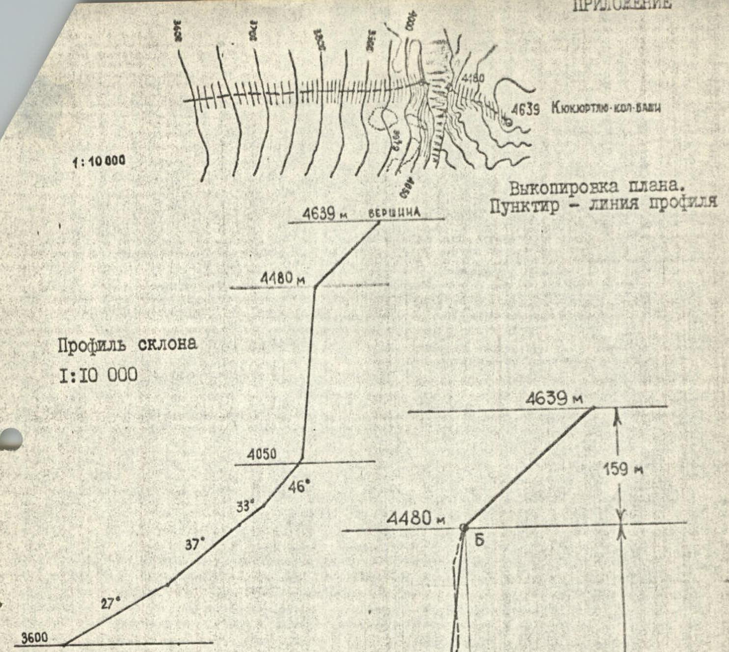
Profile of the slope 1:10 000
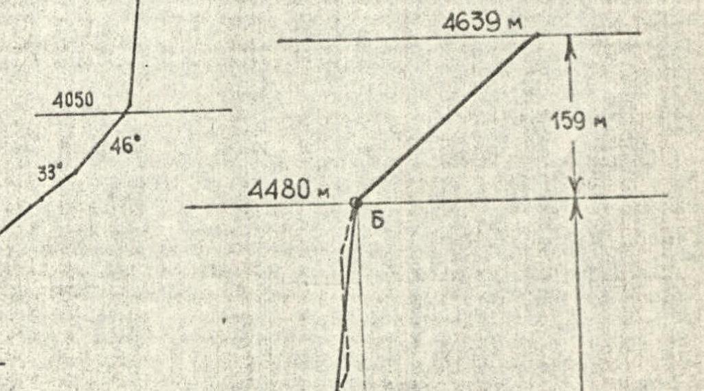
Profile of the slope on a scale of 1:5000
The solid line between points A and B is the averaged profile of the wall: 4050 m.
In reality, the actual profile of the wall section of the slope has a complex configuration; however, its line should close on points A and B, which are 60 m apart. (The dashed line on the diagram is an arbitrary line, as one of the possible examples of closing the marks of the base and the upper edge of the wall).