- Proposed difficulty category 2B
- Route characteristics: height difference 500 m, average steepness 35°, section lengths: I — 300 m, II — 250 m, III — 300 m, IV — — m, V — — m, VI — — m.
- Pitons hammered in: for belay, for creating I.T.O.: — rock: 0 — ice: 34 — bolt: 0
- Travel time 4 hours
- Number of nights and their characteristics
- Surname, name, patronymic of the leader and participants, their sports qualification:
- Ershov Andrey Alexandrovich, Pr.
- Chertov Alexey Vitalyevich, Pr.
- Team coach Golovin A. A.
- Date of departure and return February 1, 1978
Brief Description
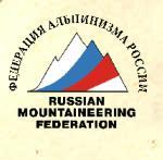
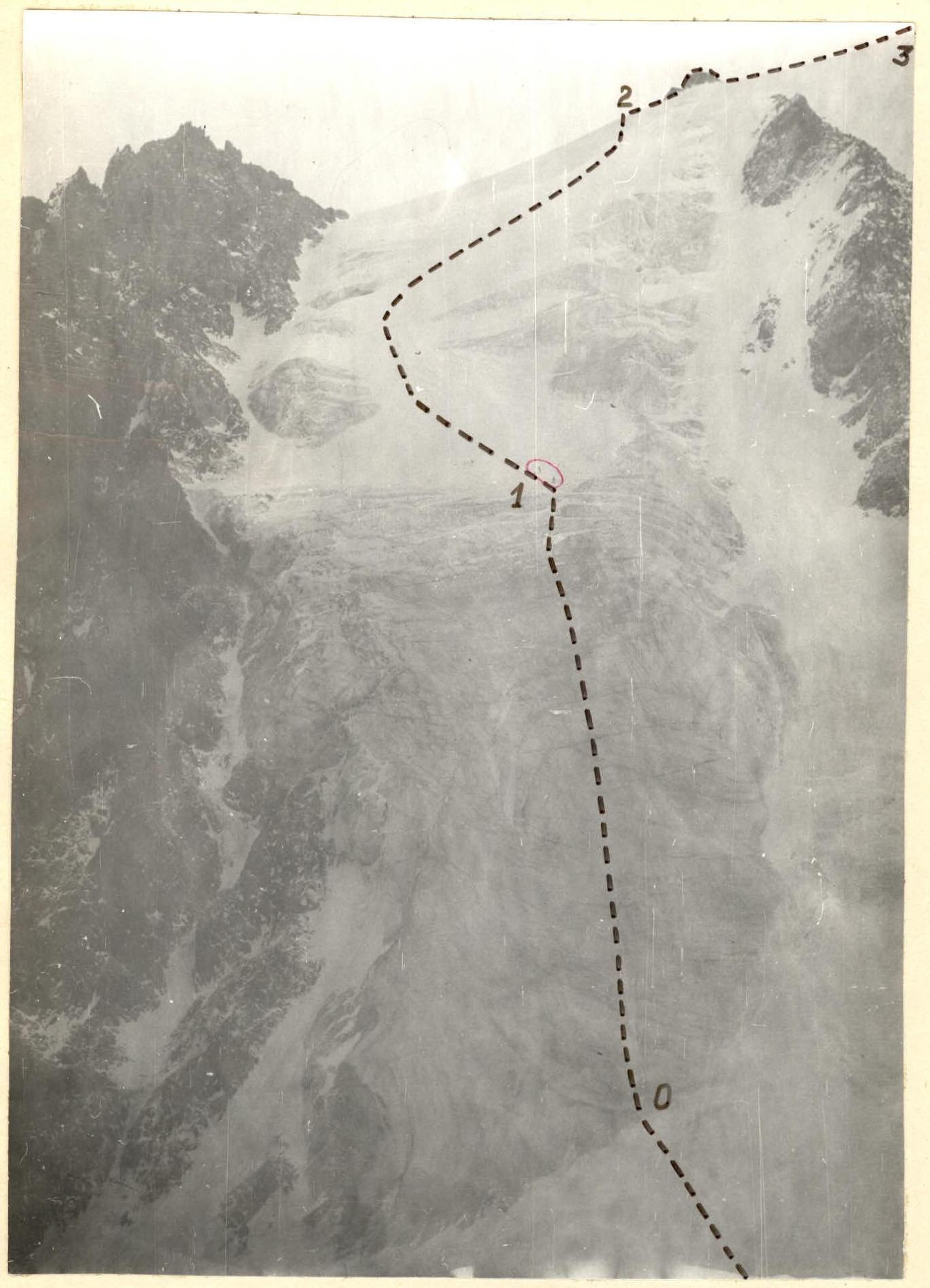
From the "Dzhantugan" alpine camp, move up the road. Having passed the Koshey clearing, turn left behind a small drying stream and climb up the trail, first through the forest, then through grassy slopes, and then scree until you reach the VTsSPS pass. On the pass — the initial bivouac. From the "Dzhantugan" alpine camp — 3 hours. From the VTsSPS pass, descend to the Kurmy glacier and along it to the glacier flowing from the ridge between the Kurmychi peak and peak I Maya. From the pass — 15–20 minutes. The ascent along the glacier is somewhat to the right of the center. The 300 m ice slope with a steepness of 40° is traversed on the front teeth with alternate belay through pitons. Further, the glacier is covered with snow, and along the 20°–30° snow slope, ascend first to the left, and then to the right-up to the ridge, bypassing individual ice outcrops. Before the ridge, there is a bergschrund, which is traversed along a snow bridge. Along the ridge to the right — to a small gendarme of simple destroyed rocks. The gendarme is traversed head-on, and further along the gentle snow ridge — the ascent to the Kurmychi peak. From the VTsSPS pass — 3 hours. Descent from the peak along simple rocks of the Northwest ridge to the VTsSPS pass — 30 minutes.
Section Characteristics
| Date | Designation | Average steepness in degrees | Length in m | Relief characteristics | Difficulty | Condition | Weather conditions |
|---|---|---|---|---|---|---|---|
| February 1, 1978 | R0–R1 | 40° | 300 m | Ice slope | 3 | ice | strong wind with snow |
| R1–R2 | 25° | 250 m | Snow slope | 2 | snow | ||
| R2–R3 | 10° | 300 m | Snow ridge | 1 | snow |
Pitons
| Rock | Ice | Bolt |
|---|---|---|
| 0 | 34 | 0 |
Roping via ice axe, simultaneous movement.
Mt. Kurmychi, 4050 m
Taken on July 21, 1987 at 11:00 from v.MNR/C/. Camera "Salut-S", lens "Mir-26V", F=45 mm.
- Along the 3rd slope of the N ridge (A. Ershov, 1978), 2B difficulty category;
- Along the C. kf. NW wall (Vetrov, 1978), 2A difficulty category;