Passport
- Technical class.
- Central Caucasus.
- Donguzorun via M. Khergiani route on the North face.
- 5B difficulty category.
- Elevation gain: 1618 m, length 1900 m.
Length of sections:
- 5th cat. diff. 1205 m.
- 6th cat. diff. 70 m.
Average steepness of the main part of the route — 62° Total route — 57° 6. 2 pitons left on the route.
4 previously driven pitons were used.
Driven pitons:
| rock | chocks | bolt | ice |
|---|---|---|---|
| 24/2 | 58/8 | 0/0 | 71/4 |
- Team's travel hours — 27 hours, days — 3.
- Overnights: 1st, 2nd sitting, carved on a snow-ice slope. 3rd overnight stay on descent, lying down.
- Leader: Volodin Viktor Gennadievich — Master of Sports, Moscow.
Team members:
- Volkov Vadim Valerievich — Master of Sports, Moscow.
- Pehtereiv Igor Vasilievich — Candidate for Master of Sports, Moscow.
- Yablokov Konstantin Yurievich — Candidate for Master of Sports, Moscow.
- Coach: Timme Egor Anatolievich — Master of Sports, Moscow.
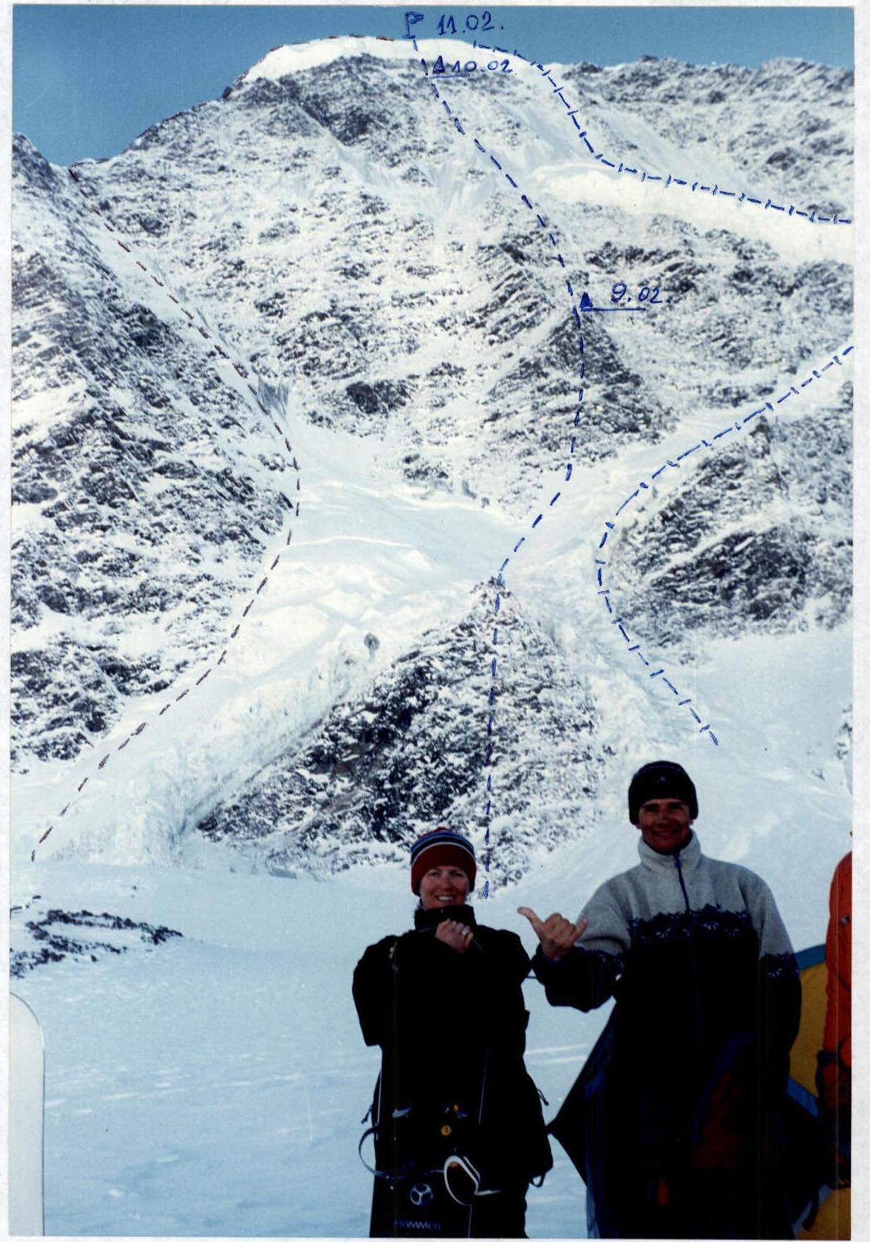
- Route entry: February 9, 2000.
Summit: February 11, 2000.
Return: February 12, 2000.
12. Moscow City Federation of Mountaineering and Rock Climbing.
General Photo
The team's route is 5B through the center of the North face, ice slopes 5A (Kukhar), via NW ridge and NE ridge 48 (Romotaev).
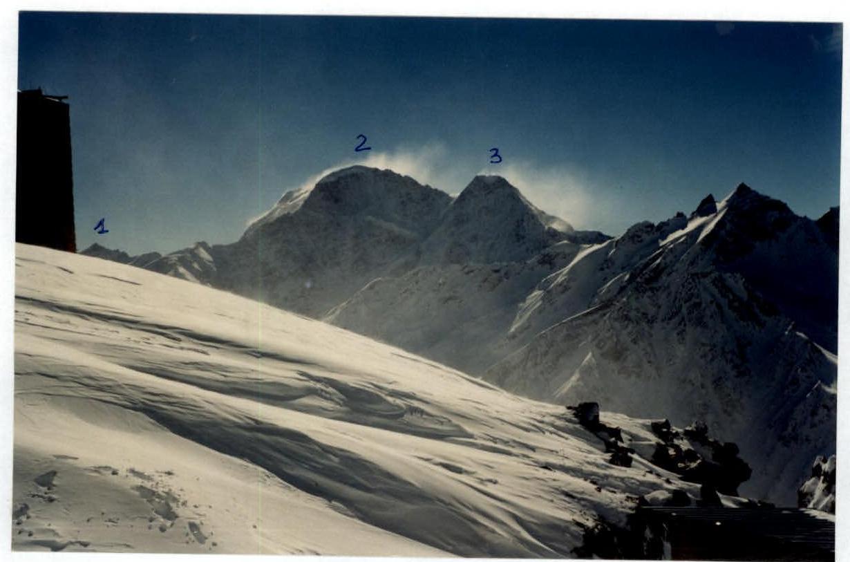
Photopanorama of the area
- Kogutai peak 3891 m
- Donguzorun peak 4468 m.
- Nakra peak 4451 m.
Team's Tactical Actions
The ascent was carried out according to the tactical plan. On sections of 2nd-4th difficulty category, the rope teams moved independently. On sections of 5th-6th difficulty category, movement was via fixed ropes. Belaying was typically done through a loop on three anchors. The following were used:
- chocks
- rock pitons
- ice screws
In cold weather conditions (temperature ranged from -26 °C at night to -15 °C during the day) and heavily snow-covered and ice-covered rocks, it was necessary to keep gloves on, which complicated the movement of the lead climber. Due to the good cohesion and physical fitness of the team, the rope teams moved in sync without delay, with regular changes of the lead climber; each participant worked as the lead on the route. For the safety of the lead climber on ice-covered rocks, ice screws with a running knot were used. It was also necessary to knock off the ice accretion on rocks, which was unsuitable for anchoring. On ice, ice screws with special elongated handles were used, but even with these tools, screwing in the pitons was very difficult. Overnight stays were organized in safe locations under rock overhangs.
There were no falls or injuries. During the ascent, one observer with a radio was stationed below the route on the moraine, and another in the settlement of Terskol, allowing for quick transmission of information to the rescue service. Radio communication was regular.
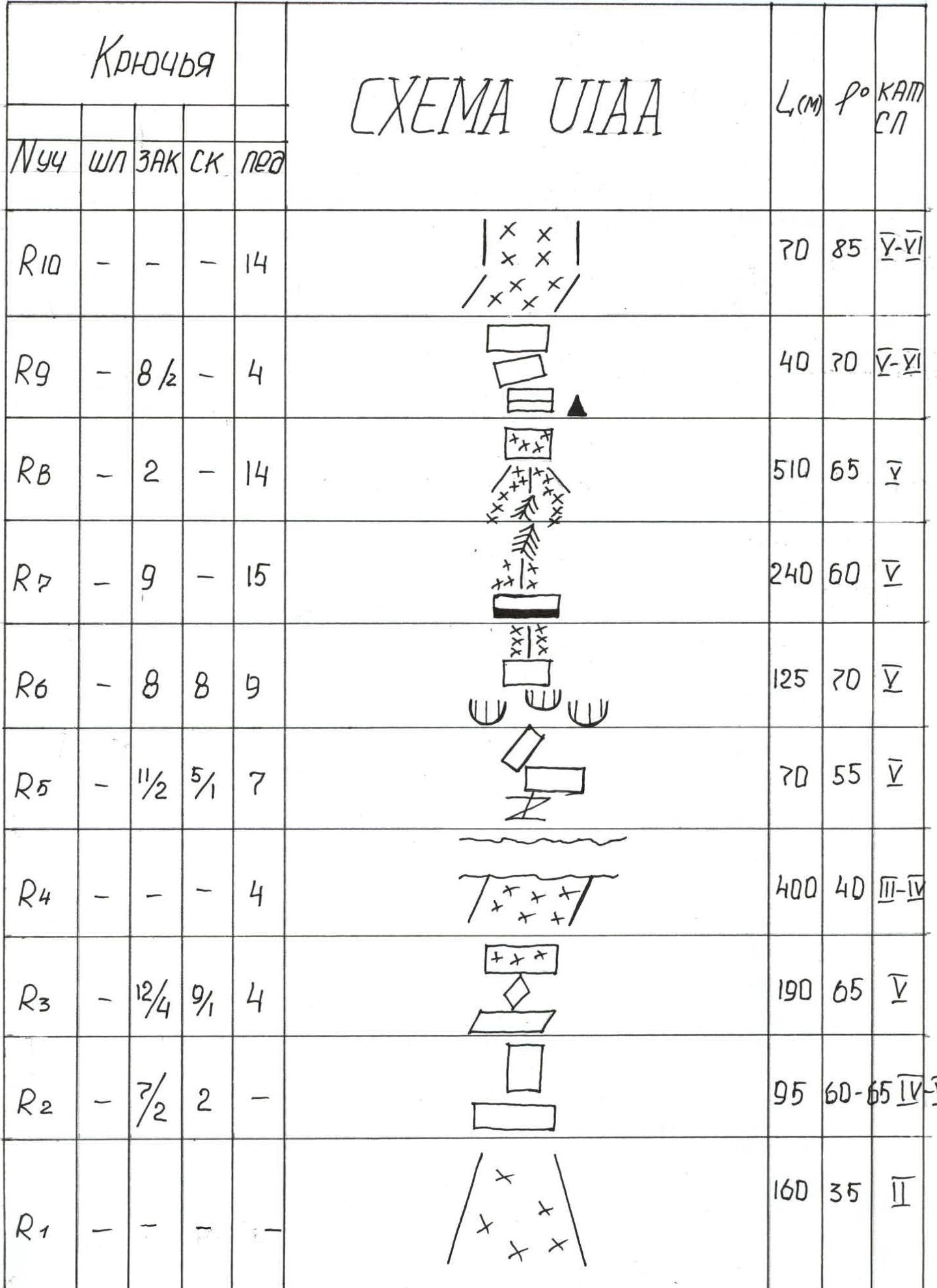
Route Scheme in UIAA Symbols
| Pitons | Ropes | Chocks | Rock | Ice | L(m) | Belay | cat. diff. |
|---|---|---|---|---|---|---|---|
| R10 | - | - | 14 | X | 70 | 85 | V–VI |
| R9 | - | 8/2 | - | 4 | 40 | 30 | V–VI |
| R8 | - | 2 | - | 14 | 510 | 65 | V |
| R7 | - | 9 | - | 15 | 240 | 60 | V |
| R6 | - | 8 | 8 | 9 | 125 | 70 | V |
| R5 | - | 1/2 | 5/1 | 7 | 70 | 55 | V |
| R4 | - | - | - | 4 | 400 | 40 | III–IV |
| R3 | - | 12/4 | 9/1 | 4 | 190 | 65 | V |
| R2 | - | 7/2 | 2 | - | 95 | 60–65 | IV–VI |
| R1 | - | - | - | - | 160 | 35 | II |
|
Route Description by Sections
R0–R1:
- From the moraine, across the glacier, along a snowy slope to the outcrops of the lower rock triangle.
R1–R2: Rocks of medium difficulty, 60–70 m straight under a 25-meter wall, difficult climbing, cracks filled with ice.
R2–R3: Then 160 m along broken rocks under a 30-meter steep wall, exit to the top of the lower rock triangle.
R3–R4: From the triangle, 400 m along an ice-snow slope to the left side of the second rock triangle, the bergschrund is heavily torn.
R4–R5: Through a cleft in the second triangle, exit to an inclined ledge, from the ledge 70 m up difficult slabs, ice accretion breaks off in slabs.
R5–R6: Then 65–70 m along ice-covered rocks of the "ram's forehead" type, exit under simpler rocks 60 m, alternating with small walls, ascent to a snowy ridge and along it to an ice-snow shoulder, overnight stay.
R6–R7: From the shoulder, 90 m up along a snow-ice ridge, then 150 m along a rocky ridge.
R7–R8:
- From the ridge, 50 m up to the right, steep ice slope.
- Then a rocky ridge under a 300-meter ice slope and approach under the rocks of the summit rise.
- Then traverse left through an ice gully and along the edge of the gully, 160 m up under the ice cap.
- On the ridge, a platform is carved out for an overnight stay.
R8–R10: From the overnight stay, up along ice-covered rocks to a 30-meter slope under a 40-meter ice wall, straight up the ice wall to the summit.
Technical Photo
The team's route.
- Overnight stay locations.

On section R5–R6.
