Dedicated to the memory of Mikhail Khergiani
73
Report
- on the first ascent of Donguzorun (Main) via the North wall, 5B category of difficulty
Central Caucasus
1978
Team of instructors at the Baksan alpine camp:
- Stadnik V.F. — CMS
- Chegel V.I. — CMS
Team coach — Korolenko N.Ya.
The adopted tactical plan was fully justified, allowing for maximum safety and completion of the route in the shortest time possible.
Radio communication between the assault team and the observation group was maintained using "Vitanka" radios. Observers transmitted information to the Baksan alpine camp via the "Nerra-P" radio station. According to the tactical plan, in case of radio failure, a signaling system using flares was planned. Flares were also used to urgently call the other party for radio communication.
During the ascent, there were no instances of radio communication loss due to radio failure or subscriber issues.
6. Support group and its tasks
The observation group consisting of:
-
- Panasyuk I.O. — CMS, senior observer
-
- Belan N.I. — Judge — recorder
was stationed on the moraine under the North wall of Donguzorun during the ascent of the main group. The group conducted visual observations and maintained two-way radio communication.
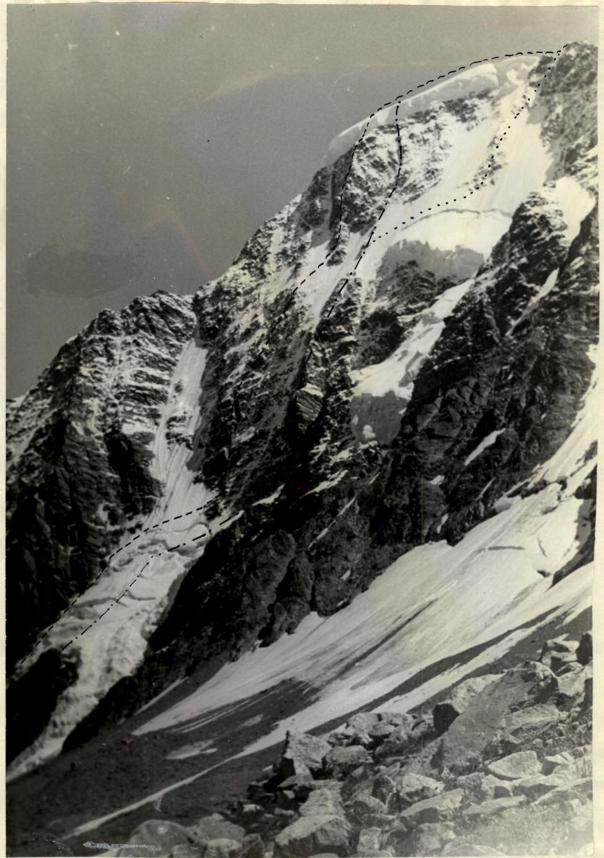
7. Route progression
July 21
From the bivouac on the moraine near the North wall, the group set out on the route at 12:00. First, they moved along the moraine, then along the boundary between ice and rocks on the northwest counterfort (R0–R1–R2), ascended above the rocky island and further to the overhanging rocks of the northwest counterfort (R2–R3). Here, they set up a bivouac in a safe location. The icefall in the middle part has a steep, difficult-to-pass section — an ascent, which is bypassed by complex rocks resembling "ram's foreheads". The steepness of the icefall is 50–60°, and the rest of the section is 40–45°.
July 22
At 01:00, the weather deteriorated sharply, with rain, followed by snow and sleet, and low clouds covering the slopes. This continued until 21:00, and the group did not proceed on the route. During brief periods of improving weather, observations of the route were made, noting the intensity of rockfall.
July 23
By 02:00, the weather improved, it cooled down, and at 03:00, the group began crossing the ice couloir between the northwest counterfort and the North wall (R3–R4). The couloir has a steepness of 50–55°, with grooves up to 1.5 m deep along it, posing certain difficulties. The couloir was traversed in crampons with piton protection. After overcoming 240 m of the couloir, the pair approached the base of the wall. The rocks in this part of the wall:
- are covered in ice,
- have few footholds and cracks for piton placement.
The 20-meter high wall (section R4–R6) is climbed directly, leading to a snowy shelf. Above the shelf, a 90–100 m high wall overhangs. Along a steep shelf (R5–R6) to the right for 40 m — an exit to a large internal angle, crossing the lower part of the wall from right to left upwards.
The lower part of the angle is hazardous due to potential rockfall and is bypassed on the left via a series of steep (75–80°) rock walls, alternating with small shelves and terraces covered in ice and snow. Then, there's another move to the right upwards towards the internal angle.
The middle and upper parts of the angle are shielded by overhanging walls on the right, protecting it from rockfall (R7–R8). The angle's steepness is 75°. Its walls consist of smooth slabs with few footholds. For protection, wedges of various thicknesses are used effectively. Climbing the angle is difficult.
Up the angle for 50 m to the upper overhanging part. Here — an exit to the left onto a small ledge (control cairn). From the control cairn, 40 m upwards along steep rocks on the left part of the internal angle (R8–R9) (live rocks). Another 40 m to the left upwards (R9–R10) along icy, wet rocks — an exit under an overhanging wall 40 m high.
The monolithic wall (R10–R11) is climbed on the right via a smooth, icy angle using artificial aids. Bypassing the wall on the right along destroyed rocks covered in snow and ice is hazardous due to potential rockfall from the right couloir.
From the wall, 80 m upwards (R11–R12) along complex, icy rocks with a steepness of 75–80° — an exit under a smooth wall 4 m high. Under the wall to the right for 30 m (R12–R13) to a smooth slab, which is overcome via a small crevice with an exit under a 10 m high wall (R13–R14).
To the left and downwards from the wall under the overhanging rock, there's a small ledge. Here, the pair left their backpacks at 14:30, and Chegel climbed up 10 m along the left part of the wall (continuous climbing) and then another 50 m along steep rocks. A more convenient bivouac site was not found on this section, so the group set up a bivouac on the ledge under the overhanging rock.
Perils were organized, and the tent-sack was stretched on pitons. For cooking, they used hacked ice. At 16:00, the weather deteriorated sharply, with snow and sleet, and a thunderstorm began.
July 24. The entire day was marked by bad weather, with heavy snowfall. Visibility did not exceed 15–20 m. The group did not proceed on the route.
July 25. By 01:40, the precipitation stopped, and some clearing occurred. At 04:15, the group resumed the ascent. Rocks and ropes were covered in ice, greatly hindering movement. They ascended 50 m upwards (R14–R15) via previously installed perils.
From the perils:
- along a steep, snowy shelf 30 m to the right (R15–R16);
- from below upwards 60 m (R16–R17) along steep, icy slabs;
- along a series of walls 3–6 m high and 80 m upwards (R17–R18) with very complex climbing to the walls of the ice field.
From here, a traverse to the left for 20 m (R18–R19) through an ice groove to a rocky ridge. Along steep, icy rocks of the ridge, an ascent of 60 m (R19–R20) to the right part of the rocky island.
In the middle part of the island, a 30–40 m high wall overhangs, under the protection of which the group gathered to cross the ice field separating the left and right counterforts of the North wall.
From the island to the right upwards along an icy slope with a steepness of 65–70° for 150 m (R20–R21) to the rocks at the base of the right counterfort. The slope was overcome using front points of crampons with the aid of ice screws and ice pitons, as well as ice axes. The first climber ascended without a backpack, which was then pulled up. Overcoming the slope required significant physical effort and was technically very demanding.
The exit onto the counterfort was via a snowy, steep shelf with live rocks (R21–R22). Along the counterfort for 160 m (R22–R23) of heavily iced and snowy rocks with a steepness of 70–75° — an approach under a vertical wall forming a steep ascent of the counterfort. Along the right part of the wall (R23–R24) vertically upwards for 30 m (artificial aids, technically and physically very complex climbing). Above the wall, at 14:50, they stopped for a bivouac on a small ledge (for 2 people) under an overhanging rock (R2 control cairn). From the bivouac, they processed the route, first 20 m along an ice-filled chimney (R24–R25), then along a smooth internal angle 30 m (R25–R26). At 18:30, they went to sleep, as this day required a significant expenditure of physical and moral strength. The entire day was foggy, with snow falling at times, and all rocks were covered in winter ice and ice formed during this bad weather. To find footholds and cracks for pitons, they had to chip away ice from entire sections of rocks. Ice axes provided invaluable assistance in this work.
July 26. No improvement in the weather was observed. Fog, and visibility did not exceed 25–30 m. All belongings were damp, and it had cooled significantly. At 04:10, the group gathered and continued the ascent.
From the perils, they passed to the right upwards for 15 m along heavily iced rocks with live stones (R26–R27) to the base of an internal angle going steeply (70°) upwards and consisting of smooth, water-covered slabs. Along the angle 70 m (R27–R28) upwards under an overhanging wall. From the upper part of the angle to the right upwards, bypassing the overhanging wall along steep, icy, narrow ledges 40 m (R28–R29) to the base of a couloir leading to the summit part of the counterfort. Along smooth slabs of the couloir 40 m upwards to the boundary of rocks and ice (R29–R30). From the rocks to the right upwards 40 m and along an icy slope (60°) to a rocky outcrop and from it to the base of the ice wall of the summit cap (R30–R31). The section is traversed in crampons using ice and one piton, as there are no cracks in the rocky outcrop. Protection under the ice wall was also organized through a piton.
The ice wall of the cap at this location is up to 35 m high and has an overhang near the counterfort, so they moved 15 m to the right, where it is vertical. Along the ice wall 28 m upwards using artificial aids (ladders) and various ice pitons (R31–R32). The ice is monolithic and holds pitons well. On the wall, there were no fresh signs of avalanches or crevasses. Therefore, it did not pose a sense of danger. In gusts of wind, only the breaking and falling of numerous icicles occurred. The passage of the wall continued from 15:30 to 20:00.
Along the snowy-icy dome of the summit (R32–R33), the pair ascended to the summit of Donguzorun (main) at 21:00 and spent the night there.
July 27. At 06:00, they departed from the bivouac and through Nakrinsky plateau, Nakrinskaya dhirka, and the pass of Donguzorun glacier returned to the Baksan alpine camp.
8. Conclusion and recommendations for the route
The route taken to ascend Donguzorun via the North wall is technically very complex. This route has the following characteristics:
- A significant part of the route has a steepness of 70–75°.
- A large amount of ice significantly complicates the passage of rocky sections.
- Protection on rocky sections of the route was achieved using conventional rock pitons and wedges. On the initial sections, ice screws were used for this purpose. For creating artificial footholds, ice pitons were also used.
- The significant steepness and length of the route demand good physical conditioning.
- The presence of an overhanging ice cap above the route induces heightened psychological tension due to the potential for ice fall. Near the cap, it does not evoke a feeling of objective danger. The wall is exceptionally beautiful and unique.
- On the route, there are no places suitable for good overnight stays for a group of more than 2 people, especially well-protected sites.
- Rockfall and ice fall along the couloir between the northwest counterfort and the wall, and along the groove between the wall and the right counterfort of the wall (via which the route of M. Khergiani passes) pose increased danger on the wall.
- The safest time on the route is from 02:00 to 14:00. After the wall is illuminated by the sun, rockfall and ice fall commence.
- The combined route along the North wall is classified as
TABLE
of the main characteristics of the ascent route to Donguzorun (Main).
Section characteristics
| Date | Designation | Average steepness in degrees | Length in meters | Terrain character | Difficulty | Condition | Movement conditions | Rock | Ice | Piton |
|---|---|---|---|---|---|---|---|---|---|---|
| July 27 | R1–R2 | 55° | 80° | 80 м | ice | 5 | monolithic | crampons | 4 | - |
| 12:00 | R2–R3 | 50° | 60 м | ice | 4 | icefall | - | - | - | - |
| 16:00 | ||||||||||
| July 24 | R3–R4 | 55° | 160 м | ice | 4–5 | dense ice | crampons | - | 6 | - |
| 03:00 | R4–R6 | 80° | 20 м | wall | 5 | monolithic | free climbing | 4 | - | - |
| R5–R6 | 65° | 40 м | shelf | 3 | live rocks | free climbing | 3 | - | - | |
| R6–R7 | 80° | 50 м | walls, shelves | 3 | destroyed shelves | free climbing | 7 | - | - | |
| R7–R8 | 75° | 50 м | internal angle | 5 | monolithic | free climbing | 6 | - | - | |
| R8–R9 | 80° | 40 м | walls | 4–5 | icy rocks | free climbing | 5 | - | - | |
| R9–R10 | 70° | 40 м | wall | 3 | wet rocks | free climbing | 7 | - | - | |
| R10–R11 | 80° | 40 м | internal angle | 5 | smooth rocks | artificial aids | 9 | - | - | |
| R11–R12 | 75° | 80 м | Wall | 5 | icy rocks | artificial aids | 14 | - | - | |
| R12–R13 | 65° | 30 м | steep shelf | 4 | destroyed rocks | -"- | 3 | - | - | |
| 14:50 | R13–R14 | 80° | 10 м | wall | 5 | monolithic | -"- | 4 | - | - |
| July 25 | R14–R15 | 80° | 50 м | Wall | 5 | icy rocks | -"- | 8 | - | - |
| 14:15 | R15–R16 | 50° | 20 м | shelf | 4 | icy rocks | -"- | 4 | - | - |
| R16–R17 | 70° | 60 м | slabs | 5 | icy rocks | -"- | 7 | - | - | |
| R17–R18 | 80° | 80 м | Walls, shelves | 5 | icy and destroyed rocks | free climbing | 12 | - | - | |
| R18–R19 | 70° | 20 м | ice groove | 5 | ice accretion | crampons | 4 | 1 | - | |
| R19–R20 | 70° | 60 м | Wall | 5 | icy rocks | crampons | 7 | - | - | |
| R20–R21 | 70° | 150 м | icy slope | 5 | ice accretion | crampons | 2 | 8 | - | |
| R21–R22 | 70° | 30 м | steep shelf | 5 | icy rocks | crampons | 5 | - | - | |
| R22–R23 | 70° | 110 м | ridge | 5 | icy rocks | free climbing | 18 | - | - | |
| R23–R24 | 85° | 30 м | Wall | 5–6 | monolithic | artificial aids | 12 | - | - | |
| 16:30 | ||||||||||
| July 26 | R24–R25 | 80° | 20 м | chimney | 5 | icy rocks | free climbing | 5 | - | - |
| R25–R26 | 70° | 30 м | internal angle | 5 | -"- | -"- | 8 | - | - | |
| R26–R27 | 65° | 15 м | wall | 5 | -"- | -"- | 6 | - | - | |
| R27–R28 | 70° | 70 м | internal angle | 5 | -"- | -"- | 10 | - | - | |
| R28–R29 | 65° | 40 м | steep shelf | 5 | icy rocks | free climbing | 9 | - | - | |
| R29–R30 | 70° | 40 м | couloir | 5 | -"- | -"- | 7 | - | - | |
| R30–R31 | 65° | 60 м | icy slope | 5 | monolithic ice | crampons | 2 | 8 | 2 | |
| R31–R32 | 90° | 28 м | ice wall | 6 | monolithic ice | artificial aids | - | 24 | - | |
| R32–R33 | 40° | 80 м | icy slope | 3 | crampons | - | - | - |