- Climbing type — rock climbing.
- Climbing area — Central Caucasus, Main Caucasian Range.
- Peak: Volnaya Ispaniya (4200 m) via the NE edge.
- Category 5B complexity (Subortovich route)
- Route characteristics:
Average steepness of the main wall section — 78°. Average steepness — 48°. Height difference — 480 m. Length of sections: Category difficulty section — 135 m.
- Pitons hammered in:
| rock | ice | bolt | chocks |
|---|---|---|---|
| 18 + 11^X | 7 | 2^X | 19 |
| 0 | 0 | 0 | 0 |
x) reuse of previously hammered pitons.
- Climbing hours — 11.5.
- Number of bivouacs — none.
- Team leader: Kostromitinov Aleksey Dmitrievich CMS
Team members:
- Melnik Mikhail Iosifovich CMS
- Moskalev Andrey Anatolyevich CMS
- Bibayev Nikolay Ivanovich CMS
-
Team coach: Suprun Valeriy Ivanovich
-
Date of departure on the route: August 21, 1988. Peak: August 21, 1988. Return to AUSB "Shhelda": August 21, 1988.
-
Organization: Voroshilovgrad Regional Alpine Club.
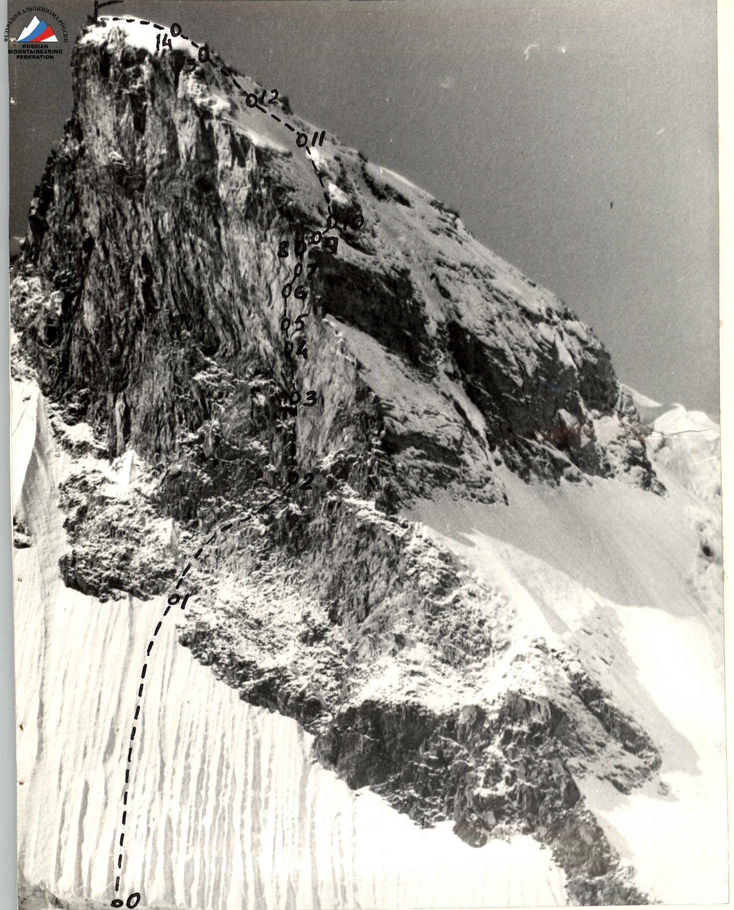
Photo #1. Route to peak Volnaya Ispaniya via the NE edge, category 5B complexity. Date taken — August 23, 1988, 14:00. Height of the shooting point — 3700 m. Lens — "Vega 126", focal length — 90 mm.
The tactical plan for the ascent was based on available data on the nature and complexity of the route (consultation with Dulepov E.N., who climbed this route in the same season), as well as taking into account the conditions of the area and the state of the route at the end of summer.
Provisions were calculated for possible adverse weather conditions.
At the time the team started the route, the weather in the area was good. Cold. The snow on the route was dry, "winter" snow. After a period of bad weather, it did not melt. However, the wall part of the route was clean.
The first climber moved on a double rope (wall section of the route). One rope was for belaying — UIAA unit, the second — for rope railings (Soviet-made). Belaying was done through a braking device. The first climber had a lightened backpack (only personal items). The second climber carried the first-aid kit. The radio station was with the third team member. Belay points were organized in convenient locations, on 3 pitons.
The number of ropes in use equaled the number of team members + one, i.e., five.
On the wall section of the route, one rope (domestic) was fixed, and the other was used for belaying the partner in the rope team, who, while moving along the railings, pulled the rope for belaying the next participant. A sufficient number of ropes allowed all participants to work on a double rope (wall section of the route).
On other sections, when moving:
- the first rope team left belay points for the second rope team;
- the gap between the second participant of the first rope team and the first participant of the second rope team did not exceed 10–12 m.
The set of equipment allowed for descent (in case of an emergency) from any point on the route.
The physical and technical preparedness of the participants allowed each to work as the lead climber. For safety reasons, the lead climber worked for 4 hours, after which the lead was changed.
Weather conditions and the state of the route allowed for the ascent without the use of artificial aids.
Food was provided as follows:
- In the morning — hot meal;
- During the day — food from individual packages.
The group was provisioned with food for 2.5 days.
During the ascent, there were no falls, injuries, or illnesses among the participants.
There were no significant deviations from the planned tactical plan.
Radio communication with AUSB "Shhelda" was stable.
Team captain Kostromitinov A. D.
Team coach Suprun V. I.
Route diagram to peak Volnaya Ispaniya via the NE edge, category 5B complexity (Subortovich route).
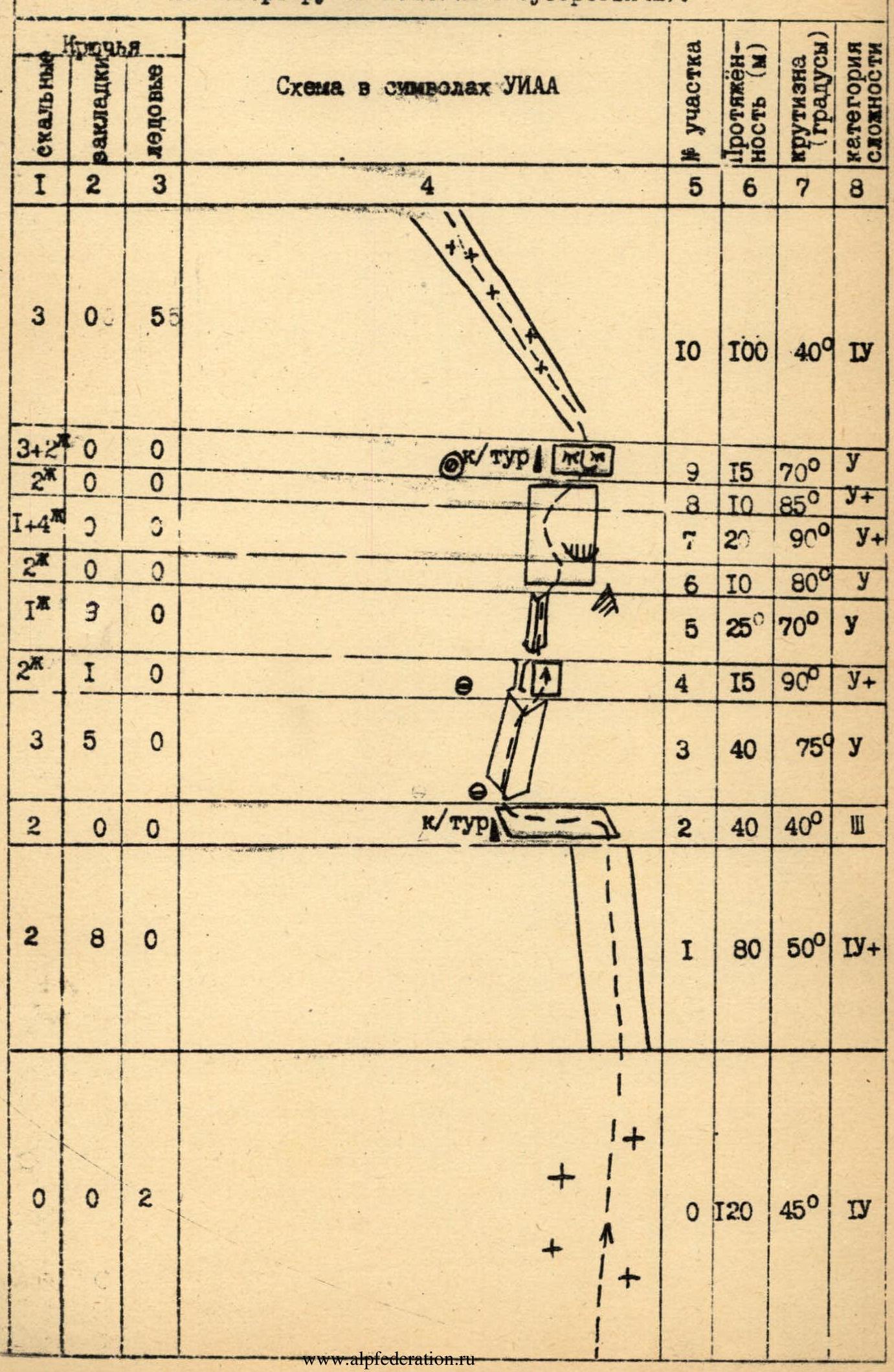
Total 11.5 climbing hours
Route description by sections
Section R0. From the glacier through the bergschrund up the snow-ice slope 120 m.
Section R1. Up the destroyed rocks to a ledge 80 m.
Section R2. Along the ledge (loose rocks, rocks are snow-covered) 40 m left to an internal corner. Control cairn.
Section R3. Straight up the internal corner 40 m, monolith.
Section R4. Right of the chimney up the wall 15 m.
Section R5. Up the internal corner — chimney, movement towards a rock spall 25 m.
Section R6. From the spall straight up and left across the wall 10 m.
Section R7. Across the wall left, bypassing an overhang 20 m.
Section R8. Across the wall right, exit to a ledge 10 m. Control cairn.
Section R9. Up a wall type "ram's foreheads" 15 m. Rocks are covered with ice.
Section R10. Up a wide groove with rock islands 100 m.
Section R11. Up a snowy ridge to rocks 40 m.
Section R12. Up a couloir with snow and ice left to the ridge 40 m.
Section R13. Up the rise of the snowy ridge 40 m.
Section R14. Along the snowy ridge (ridge becomes less steep) to the summit 120 m.