Ascent Passport
- Central Caucasus
- Peak Volnaya Ispaniya via North-Eastern Edge
- 5B
- Combined
- Height difference: 600 m (3600–4200) Route length: 825 m. Length of sections with V category of difficulty – 170 m, VI category of difficulty – 15 m. Average steepness of the main part of the route: 70°
- Hooks left on the route: 0 Hooks used on the route: 12. Artificial holds used: 13
- Time to reach the summit: 16 hours
- Team leader: Korol Evgeny Mikhailovich, Candidate Master of Sports Team members: Murushev Andrey Evgenievich, 1st sports category Sushko Denis Sergeevich, 1st sports category
- Coach: Kuznetsova Elena Valentinovna, Master of Sports.
- Departure to the route: 04:00, September 14, 2007 Summit attainment: 20:00, September 14, 2007. Return to the base camp: 15:00, September 15, 2007
Description of the Area
Twisting multiple times, changing direction from north to south, the Main Caucasus ridge stretches from the North-Eastern ridge of Shchurovsky peak in the west to the western slopes of Ullukara in the east. In the center of this section of the ridge, the ice cap of Bzhedukh peak – 4270 m – rises. East of Bzhedukh, on a short segment of the ridge, the rocky peak of Volnaya Ispaniya – 4200 m – stands tall. To the west of Bzhedukh, the ridge features peaks: Kavkaza – 4037 m, Vulley, and Zheleznodorozhnikov – 3900 m. To the north, from almost all parts of the ridge, ice and snow slopes descend, interrupted by numerous rocky spurs, ridges, and counterforts. Volnaya Ispaniya drops off with a rocky slope to the upper plateau of the Kashkatash glacier. From the southern side, the ridge rises with steep rocky walls above the Chalaat and Lekzyr glaciers.
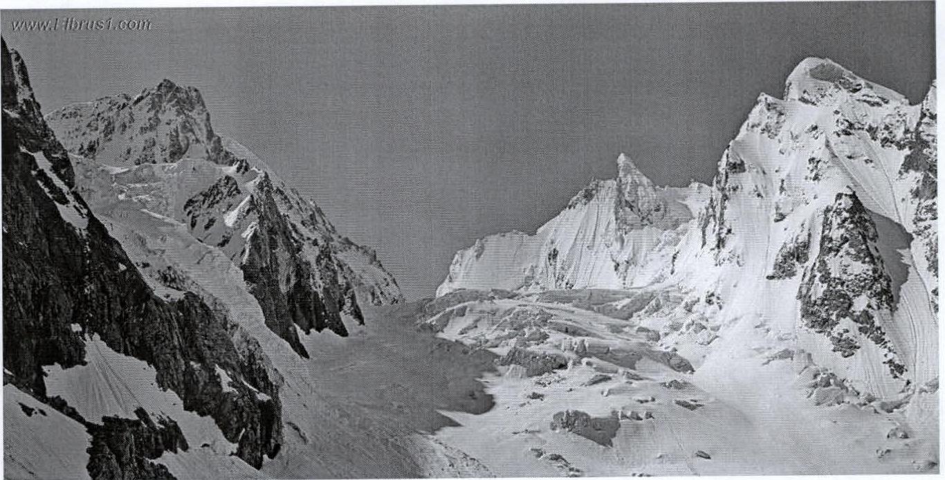
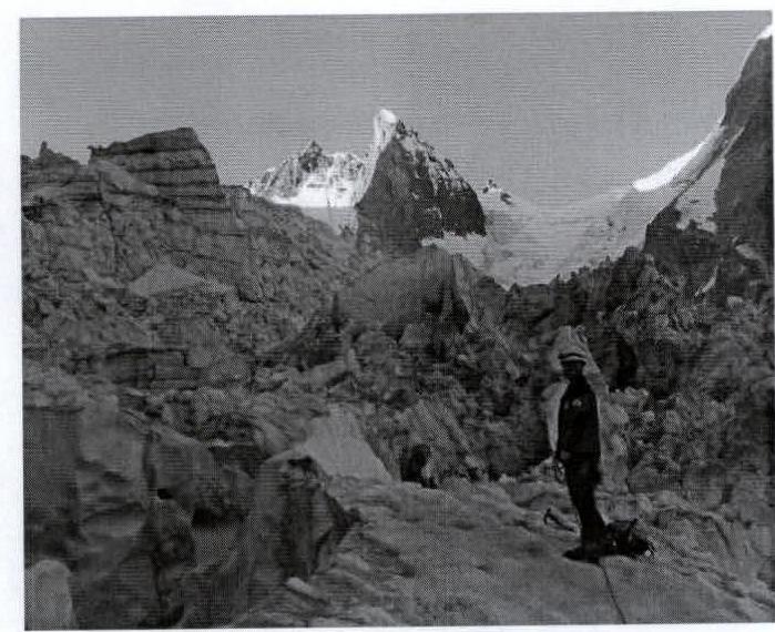
Volnaya Ispaniya (center) Ullukara (left) Bzhedukh (right)
Ascent Report with Route Description
A team of 3 climbers from CSKA named after Demchenko, Moscow, consisting of:
- Murushev Andrey
- Sushko Denis
- Korol Evgeny
On September 14, 2007, at 19:30, they completed an ascent to the summit of Volnaya Ispaniya peak via a 5B category route, along the North-Eastern Edge. Descent was made down the western slope of the peak to the western branch of the Kashkatash glacier into "Skovorodka," followed by a descent onto the glacier plateau. No notes were found in the summit log!
September 11:
- Flight from Moscow and arrival at Shhelda alpine camp.
September 12:
- From the village, cross the Adylsu river via the bridge.
- From the bridge, the trail goes through a level forest, then it is recommended to ascend via the pocket between the slope and the left-bank moraine of the Kashkatash glacier.
- After a large stone with signs and memorial plaques, continue the ascent along the moraine ridge to the platforms at its end.
- From the village of Dzhan-Tugan – 3–4 hours.
- The platforms were used for a bivouac with an overnight stay.
September 13:
- From the platforms, moved along the moraine and talus slopes alongside the glacier (live rocks).
- Then descended to the glacier and ascended along its left side.
- The ice fall of the Kashkatash glacier is bypassed to the left under the slopes of Ullukara mountain.
- From the slopes of Ullukara, a large ice fall descends with detaching and constantly falling ice scales.
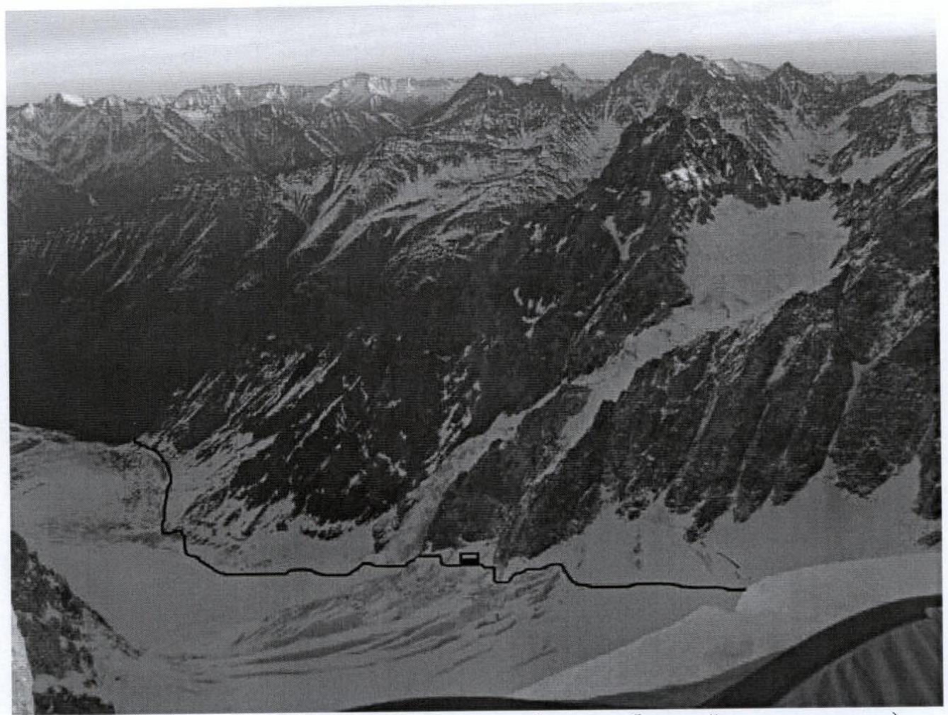
Path along the glacier to the plateau (the most problematic section of the approach is marked)
Passing the problematic section of the approach. The snow ledge under this ice fall should be crossed as quickly as possible…
The bergschrund is crossed to the left via rocks – 5–7 m, then via a steep slope with hard firn and ice, ascend upwards until it levels out. Further, ascend while avoiding numerous crevices and staying close to the walls of Ullukara mountain (attention, rockfall possible!!!) – to reach the plateau. Due to the heavily broken glacier, overcoming this section of the approach became quite challenging.
The main task of the team was to find an optimal path. However, even with the found variant, three sections of ice with a difficulty of 4–5 category and a length of 10–25 m were traversed.
In this regard:
- The ascent from the first night's bivouac to the plateau took about 9 hours.
Upon reaching the plateau, the group split: one stayed to set up the bivouac, while the other two began processing the route.
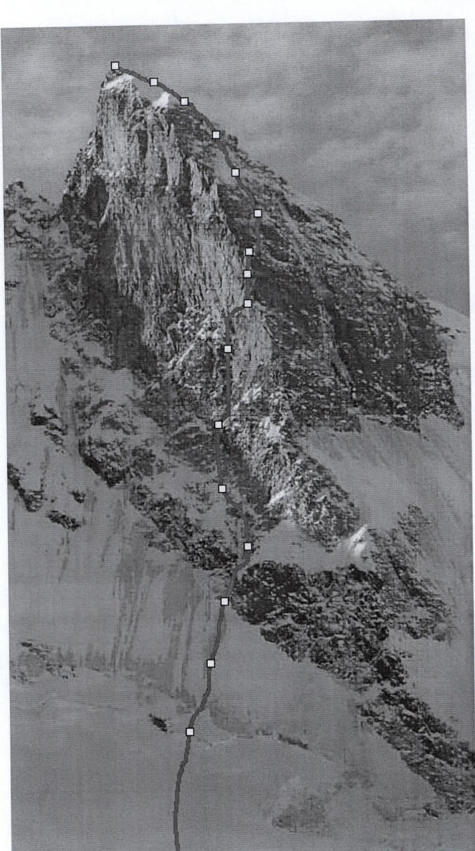
From the plateau, via a not very steep snow slope, crossed the bergschrund, and reached the north-eastern ice slope of 50–65°, and moved up 100–120 m in broken rocks of 60–80°. Belay: ice screws.
Before nightfall, two sections of 50 m each were traversed (bergschrund and almost all ice). (R0–R2)
On September 14, at 5:30, they approached station R2 and began work on the R2–R5 section. The first person worked in crampons with one ice tool.
Belay: medium-sized stoppers, large anchor hooks work well!
R5–R8 – change of leader. (These sections were traversed in rock shoes, via climbing.) The R8–R9 section was partially traversed using artificial aids (first 6 m, 5 transitions via hooks left by previous groups A2), further the leader went via free climbing V+ – VI, 19 m.
It is advisable to use long quickdraws since there are many bends on this section, and towards its end, due to significant friction, problems with rope handling arise.
Belay: stoppers and friends of all sizes, hooks, anchors.
R9–R10 – change of leader, work in crampons with two tools (icy rocks, firn).
The R10 section was iced over; the control cairn was not found.
Belay: 1 ice screw, 3 anchor hooks, after the section with artificial aids – 2 dubious pitons, 5 m apart.
R10–R13 – the first 20 m was profiled ice about 10 cm thick (belay: 1 anchor and 1 petal). Further, the ice was good until the R13 belay point (the station was set up on a rocky outcrop, with 2 anchors driven). Belay: ice screws, hooks, anchors!
R13–R15 – the section to the summit does not present problems, except for the lack of belay on the snow slope; thus, it is recommended to proceed to the summit on two ropes at once. Belay: ice screws (if you can reach the ice).
At 19:30, the group in full strength reached the summit (hurray!). No notes were found in the control cairn.
At 19:40, it suddenly got dark, and the weather also deteriorated sharply (snowstorm), wind 20–30 m/s. In connection with this, a decision was made to spend the night on a platform under the summit (the platform was good).
Bivouac gear (which they brought):
- single-layer nylon tent
- 2 down jackets
- 1 sleeping mat
- burner
- 150 g of gas
(very cold)
During the night, they had to dig out the tent twice as it was almost buried. From 00:30 to 2:00, a thunderstorm passed over the summit. In connection with this, a rope (rappel) was uncoiled down the slope. At 4:30, the snowstorm stopped, but the wind strengthened.
On September 15, at 7:00, they began the descent. Four rappels of 50 m down the western slope of the mountain to a steep snow slope. Along the slope, in teams, descended to the center of "Skovorodka," and further, overcoming bergschrunds and crevices, descended onto the snow plateau under Volnaya Ispaniya peak (the site of their bivouac). By 15:00, they settled in for the night.
On September 16, at 6:00, they began the descent from the plateau via the ice fall. Due to the collapse of a snow bridge connecting 2 seracs, traversing the ice fall downwards took 10 hours.
At 23:30, they departed to Mineralnye Vody.
On September 17, arrival in Moscow.
Total: the journey from Moscow to Moscow via the summit took 6 days (hurray!).
P.S. We apologize for the extreme scarcity of photographic material. There was no camera; photos were taken with a phone (which also ran out of battery very soon).
Technical Description of the Route
- R0. Along the snow slope under the bergschrund beneath the eastern wall – 150 m, 1.
- R0–R2. Along the ice slope under a short, weakly expressed rocky couloir in the lower left part of the eastern wall – 100 m, 3.
- R2–R5. Up simple icy rocks to the base of an internal angle, resembling an open book – 150 m, 3–4.
- R5–R6. Up the internal angle – 50 m, 4–5.
- R6–R8. Along a large slab sloping upwards to the right – 70 m, 5.
- R8–R9 (section length 25 m): Up the wall 6 m via driven hooks, VI+ A1, then 19 m VI–V+, A2 to a ledge with two hooks R9.
- R9–R10 (section length 40 m, IV–VI A2): 3 m up and to the right via rocks. 4 m traverse along a ledge iced over, into a snow-ice crevice. Through 4 m, an overhanging ledge in the couloir via artificial aids A2, 3 transitions (own hooks). Staying close to the rocky wall on the right side of the icy couloir, exit to the top (about 30 m) – a dubious piton and a control cairn.
- R10–R13: Up the couloir – 20 m, 5, then 100 m, 5, and 20 m, 4.
- R13–R15: 20 m to the snow slope, 4. Along the snow slope up to the summit – 80 m, 2.
Descent along the western ridge into the icy couloir between Volnaya Ispaniya peak and Bzhedukh peak – 200 m, 3, then down the couloir to the Kashkatash glacier plateau – 600 m, 2.
| Section | заклад. | Rock hooks | Ice hooks | UIAA scheme | Length m | Steepness deg. | ||
|---|---|---|---|---|---|---|---|---|
| R15 | 2 | 100 | 40 | |||||
| R13 | 3 | 3 | 3 | 145 | 55 | |||
| R10 | 10 | 5 | 4–5 | 45 | 90 | |||
| R9 | 5 | 5 | 25 | 90 | ||||
| R8 | 8 | 3 | 5 | 70 | 70 | |||
| R6 | 5 | 2 | 4–5 | 50 | 80 | |||
| R5 | 3 | 8 | 3 | 150 | 60 | |||
| R2 | 2 | 3 | 100 | 50 | ||||
| R0 | 1 | 200 | 30 |