- CLASS OF TECHNICAL ASCENTS
Report
ON THE FIRST ASCENT TO THE SUMMIT OF CHEGEM (4461 m) ALONG THE NE EDGE OF THE N-E RIB, APPROXIMATELY 5B CATEGORY OF DIFFICULTY, BY THE TEAM OF INSTRUCTORS FROM THE "ULLUTAU" ALPINE CAMP. A. Kurochkin, V. Ivashkin, A. Lukonenko, V. Poliansky, A. Sayapin, V. Smirnov July 31 – August 4, 1984.
Team Leader: Kurochkin A.G.
Team Coach: Porokhnya Yu.I.
361602, KBAASSR, Verkhny Baksan settlement, "Ullutau" alpine camp
360017, Nalchik, Kirova st., 12, apt. 50 Porokhnya Yu.I.
364046, Grozny, Verkhoyanskaya st., 4A, apt. 99 Kurochkin A.G.
Altitudes were determined using the VP № 26020 altimeter and a map.
Distances to the object from photo shooting points were determined visually.
Photo 12. Route profile from the left. Date taken: 31.07.84, camera: "Zenit", lens: "Helios-44", distance: 800 m, shooting point №2, altitude: 3380 m.
Photo 143. Route profile from the right. Date: 31.07.84, time: 9:30, camera: "Zenit", lens: "Helios-44", distance: 800 m, shooting point №3, altitude: 3350 m.
Description of the Climbing Area
The object of the ascent — Chegem peak (4461 m) is located in the northern spur of the Main Caucasian Range, branching off from Mestia-Tau peak. The peak is approached by three ridges: eastern, north-eastern, and western. Due to its remoteness from alpine bases, four routes have been laid to the peak so far — category 2B along the E ridge, category 3A along the W ridge, and two category 5B routes along the N and NE walls. From the "Ullu-Tau" alpine camp, the path lies along the road to the Kullumkol-su river. Then follow the trail along the right (orographically) riverbank to the fork in the trail (1–1.5 hours from the camp). Continue along the trail that branches off to the right, heading towards the South Yunom glacier.
At the beginning of the glacier, the trail turns left towards the moraine leading to the West Yunom glacier. The moraine ridge trail is marked with cairns. Then proceed along the moraine ridge and subsequently along the West Yunom glacier towards the Donkin pass (3950 m, category 2B, snow-ice climb), situated between the peaks of Dzhailyk and Kichkidar. The journey from the "Ullu-Tau" alpine camp to the pass takes 7–8 hours. From the Donkin pass, descend into the Chegem gorge via a steep snow-ice couloir. The pass ascent, 250 m high and with a slope of up to 60° in places, is separated from the Dzhailyk glacier by a bergschrund. Then traverse the right (in the direction of travel) part of the Dzhailyk glacier (beware of crevasses!) along the northern walls of Chegem peak until the glacier levels out into a large snow-ice plateau and the gorge turns east. On the left-bank (in the direction of travel) moraine opposite the north-eastern wall of Chegem peak's East ridge — a bivouac site (1–1.5 hours from the pass). The NE wall is 300–400 m from the bivouac.
Team's Tactical Actions
According to the tactical plan, the ascent was to be completed from July 31 to August 4, 1984. The route progression and organizational aspects largely matched the planned schedule. A contingency plan for bad weather was in place. The schedule was interrupted by bad weather, and the team waited out the weather on August 1.
The team reached the summit on August 4 at 9:00. Three rope teams were formed: Kurochkin–Smirnov, Poliansky–Sayapin, Lukonenko–Ivashkin. The leading teams took turns throughout the day, as did the lead climbers within the teams. Leadership changes occurred at sections: R1–R2; R4–R5; R7–R8; R10–R11; R12–R13; R14–R15; R18–R19; R22–R23; R23–R24; R24–R25. Rappelling was organized at points: № 0–19; 20–21–22. Movement along the route began between 6:00–7:00 AM and continued for 13–14 hours. Night halts were organized in areas safe from rockfall — hanging, sitting, and lying.
The basis for navigating the route was a scheme typical for complex wall ascents, with a leading duo changing leaders, and dispatcher duos below. The leading duo laid out the route, organized rappelling points, and reception points. Lower teams supplied them with ropes, pitons, etc., checked the equipment in use, maintained radio communication, and kept a technical log of the route. The first duo worked with a lightened backpack.
The first climber moved on a double rope with protection through Sticht plates and intermediate pitons with a Saratovkin shock absorber. Subsequent climbers followed along the rappelling lines with top-rope protection.
Safety measures on the route included:
- High technical, tactical, physical, and psychological preparation of the participants;
- A well-prepared tactical plan;
- Presence of an observation group;
- Reliable radio communication.
There were no falls or injuries on the route. A water issue at the beginning of the wall was resolved by bad weather on the first day of ascent.
Two problematic sections on the wall were successfully navigated. The passage through several smooth, wet, and icy sections of the route was facilitated by the use of drill-in pitons.
New equipment samples were used on the route:
- Drill-in pitons with cross-shaped sharpening made from R18 steel;
- Reusable drill-in pitons;
- Ladders with self-releasing hooks;
- Anchor pitons made from spring steel 65G;
- Saratovkin shock absorbers;
- Sticht plates, etc.
In bad weather conditions, when all participants got wet, everyone showed tolerance and tried to help each other with warm clothing.
Communication with observers was maintained via a "Kaktus" radio station according to a schedule. Additional communication was initiated by voice call.
Photo numbers: № 1–24
Route Diagram in UIAA Symbols. Scale 1:2000
Section 21–24 Scale 1:5000
Route Description by Sections
The base camp is located within a 20-minute walk from the NE wall of Chegem peak on the left-bank moraine of the Dzhailyk glacier. July 31, 1984. Section — start of the route — R0.
Altitude 3300 m. Lukonenko–Ivashkin rope team. An 80-meter, 25–30° snow-ice slope leads to a randkluft with a 5 m gap and 8 m depth. Category 5 terrain. The passage involves the use of artificial technical aids (I.T.O.). Climbing is dangerous and psychologically tense. Exit from the randkluft is via a vertical ice-covered wall.
Section R0–R1. Ice slope with a 75° angle, 20 m long. Category 5 terrain, leading to a vertical wall. Protection from a narrow inclined ledge. Change of lead rope team.
Section R1–R2. Smirnov–Kurochkin team leads. A vertical 5-meter green wall with few holds, category 4 terrain, leads to a destroyed ledge. Then 8 m to the right along a 50° destroyed ledge, category 3 terrain.
Section R2–R3. A vertical 12-meter wall, category 6 terrain, with monolithic, smooth rocks covered in ice, leads under a yellow 1.5-meter eave. To the right of the eave (I.T.O.) — along a monolithic 18-meter vertical wall with few cracks. Climbing is extremely difficult. Protection from an inclined ledge.
Section R3–R4. An inclined monolithic ledge type "ram's foreheads", 10 m along a 50° ledge to the left, category 4 terrain. Smooth rocks. Passage with a backpack is challenging.
Section R4–R5. Smirnov takes the lead. A vertical wall, 40 m long, category 6 terrain, with a shallow wide crack to the right of the yellow wall. 1st control point (k. tur) at an altitude of 3426 m in a can on the wall. Climbing is extremely difficult. Holds are small and smooth. I.T.O. is used. At the end, the crack narrows and leads under the right part of the black monolithic wall. Protection is in a hanging position from ladders.
Section R5–R6. Wall, 40 m long, 85–90° angle, category 6 terrain. To the right of the black wall with small smooth holds, exit onto the right edge of the black internal corner of monolithic smooth rocks type "ram's foreheads". Very few cracks; in places, the wall is impassable without aid. Drill-in pitons are used. At the top, a 0.5 m eave, then a narrow inclined 20-meter ledge with snow. A night halt is organized here. Altitude 3482 m.
Section R6–R7. Lukonenko–Ivashkin team leads. 5 m to the left from the night halt, a grey wall, 40 m long, 60° angle, category 4 terrain. In places, wet and icy rocks. Protection from a ledge for two.
Section R7–R8. Along a 10-meter, 80° internal corner of yellow rocks, category 4 terrain, and then 30 m along 70° rocks with ledges, category 4 terrain — exit under a yellow bastion with black ice formations. Protection from a ledge through a powerful block.
Section R8–R9. A vertical monolithic yellow wall with black ice formations, 40 m long, category 6 terrain. Along the boundary between yellow and black ice formations — exit onto a ledge to the left of the yellow powerful bastion, 2nd k. tur, altitude 3592 m.
Section R9–R10. Wall with ledges and large "live" blocks. Angle 50°, length 40 m, category 3 terrain. Protection from a ledge under a grey bastion.
Section R10–R11. Bastion with large, slab-like grey fragments and black ice formations. Length 50 m, angle 80°, category 5 terrain. Passage is along the central part of the bastion, to the right of the black ice formations. Climbing is difficult; protection is from a good, debris-covered ledge with blocks. To the right, 18 m along the ledge under a vertical powerful 1st pillar, night halt. Altitude 3674 m.
Section R11–R12. From the night halt, 5 m to the right onto the rib of the pillar, angle 70°, length 40 m, category 5 terrain. Large fragments with smooth holds. Climbing is tense and complex. In places, there are ice-covered sections. Protection from a ledge for two.
Section R12–R13. Smirnov–Kurochkin team leads. A monolithic 75°, 40-meter wall, category 5 terrain, with smooth and in places ice-covered relief. Very few cracks. I.T.O. is used. Protection from a destroyed ledge.
Section R13–R14. Wall of large-block structure. Length 40 m, angle 70°, category 5 terrain. Climbing is difficult due to smooth holds. At the top of the wall, at an altitude of 3778 m, 3rd k. tur in a can. Protection from an inclined ledge.
Section R14–R15. Smirnov takes the lead. A vertical yellow wall of a pillar, 40 m long, category 6 terrain, with monolithic, smooth relief. At the end of the wall, a 6-meter fragment-crack with smooth, ice-covered walls is passed by wedging at the limit of capabilities using drill-in pitons, I.T.O. Protection from a good ledge with large blocks above the fragment.
Section R15–R16. Along a 20-meter, 45°, category 2 terrain ridge with large blocks, approach under the sharp summit ridge of the 1st pillar. Protection through a protrusion.
Section R16–R17. Ridge. Length 40 m, angle 70°, category 5 terrain. Along the outer monolithic corner with small holds upwards to a wide horizontal ledge. The NE wall of the 1st pillar is passed.
Section R17–R18. A horizontal, up to 8 m wide, inclined, debris-covered ledge. From the ledge, bypassing the 2nd pillar on the left along a 40 m wall, category 2 terrain, with ledges, 40 m upwards. Protection from a good ledge.
Section R18–R19. Poliansky–Sayapin team leads. A destroyed wall, 30 m long, angle 70°, category 5 terrain. Climbing is complex, with large "live" stones. The wall is covered in snow and ice. Protection from a sharp, debris-covered saddle between the 2nd and 3rd pillars. To the right — steep drop-offs of a powerful snow-ice couloir.
Section R19–R20. Bypassing the 3. pillar on the left along a destroyed, snow-covered ridge, 100 m long, angle 35°, category 2 terrain — exit under the fragment of the 3rd pillar. Protection from a good ledge with blocks.
Section R20–R21. Fragment. Angle 70°, length 15 m, category 5 terrain. Climbing is difficult. Snow, ice, "live" stones. Protection from a wide ledge with a slight incline. Night halt. Altitude 4014 m.
Section R21–R22. Move, bypassing the 3rd pillar on the left along the left steep snow-ice couloir across a destroyed 45°, 200 m wall with ledges. Categories 2 and 3 terrain. Exit onto a snow saddle between the 3rd pillar and the East ridge.
Section R22–R23. Ivashkin–Lukonenko team leads. Snow-ice slope. Angle 30°, length 200 m, category 2 terrain. Exit onto the East ridge.
Section R23–R24. Kurochkin–Smirnov team leads. Snow-ice ridge. Average angle 40°, in places over 50°. Crevasses are encountered. Length 700 m, category 3 terrain. Ice screws are used.
Section R24–R25. Sayapin–Poliansky team leads. Pre-summit tower. Length 20 m, angle 60°, category 4 terrain. Destroyed rocks; bypass on the left and along the internal corner, exit onto the summit. Altitude 4461 m. Descent is along the category 3A route on the West ridge to the Donkin pass.
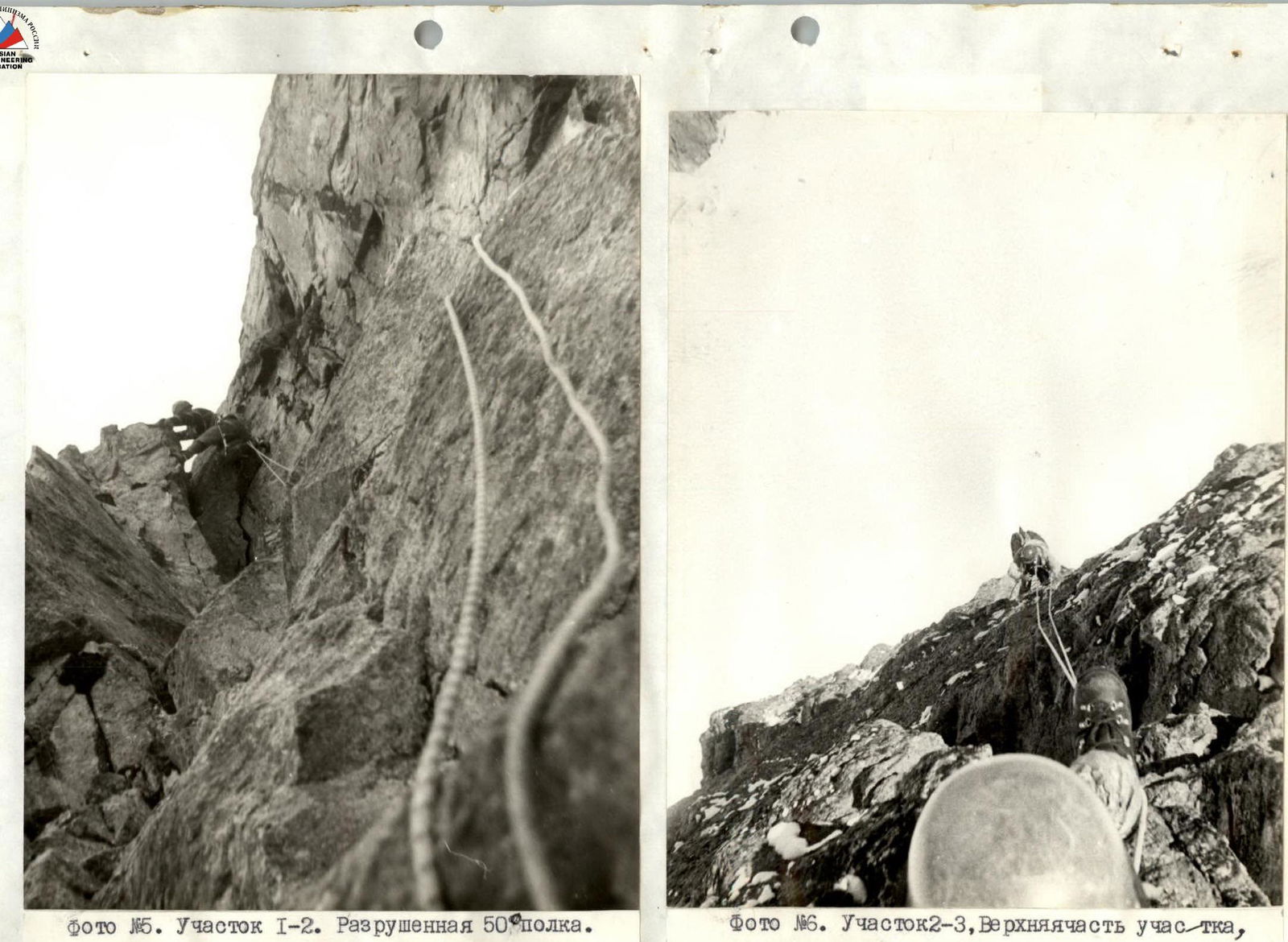
Photo 16. Section R1–R2. A 50-meter destroyed ledge.

Photo 18. Section R4–R5. Passage of the vertical wall on the section.