Ascent Log
- Ascent class: technical
- Ascent area: Central Caucasus, northern spur of the Main Caucasian Range, branching off from Mestia-Tau, Chegem node between Donkin and Freshfield passes.
- Peak, its height, ascent route: Chegem, 4461 m, combined route along the north-eastern wall of the north-eastern ridge.
- Estimated difficulty category: 5B
- Route characteristics: height difference 1290 m, average slope up to the summit ridge (i.e., up to R24 height difference 1120 m, absolute height 4320 m) — 55°. Average slope of the wall section (i.e., up to R14 height difference 435 m, absolute height 3600 m) — 88°. Length of sections: 2 — 500 m, 3 — 200 m, 4 — 650 m, 5 — 230 m, 6 — 320 m.
- Pitons driven: | For belaying | For artificial support | | :----------- | :--------------------- | | Rock 164 | 31 | | Ice 15 | 2 | | Bolts 6 | 1 |
For overnight stays, 28 rock and 3 bolt pitons were driven.
- Number of climbing hours: 42
- Number of overnight stays and their characteristics: Total of four overnight stays. R1 — on the glacier under the wall in a tent; R2 — on the wall in hammocks; R3 — on a narrow rock shelf, sitting; R4 — on a snowy ridge in a tent.
- Surname, name, patronymic of the team leader, participants, and their sports qualification:
- Forostyan Vitaliy Yuryevich — Candidate Master of Sports of the USSR
- Lesnevoy Deliien Pavlovich — *
- Tsvetkova Gelina Mikhailovna — *
- Shakalo Valeriy Matveyevich — *
- Team coach: Markov Valeriy Grigoryevich, Honored Coach of the RSFSR, Master of Sports of the USSR, senior instructor.
- Date of departure and return: June 29 — July 3, 1977.
PHOTO I. Photo of the summit from the base to the height.
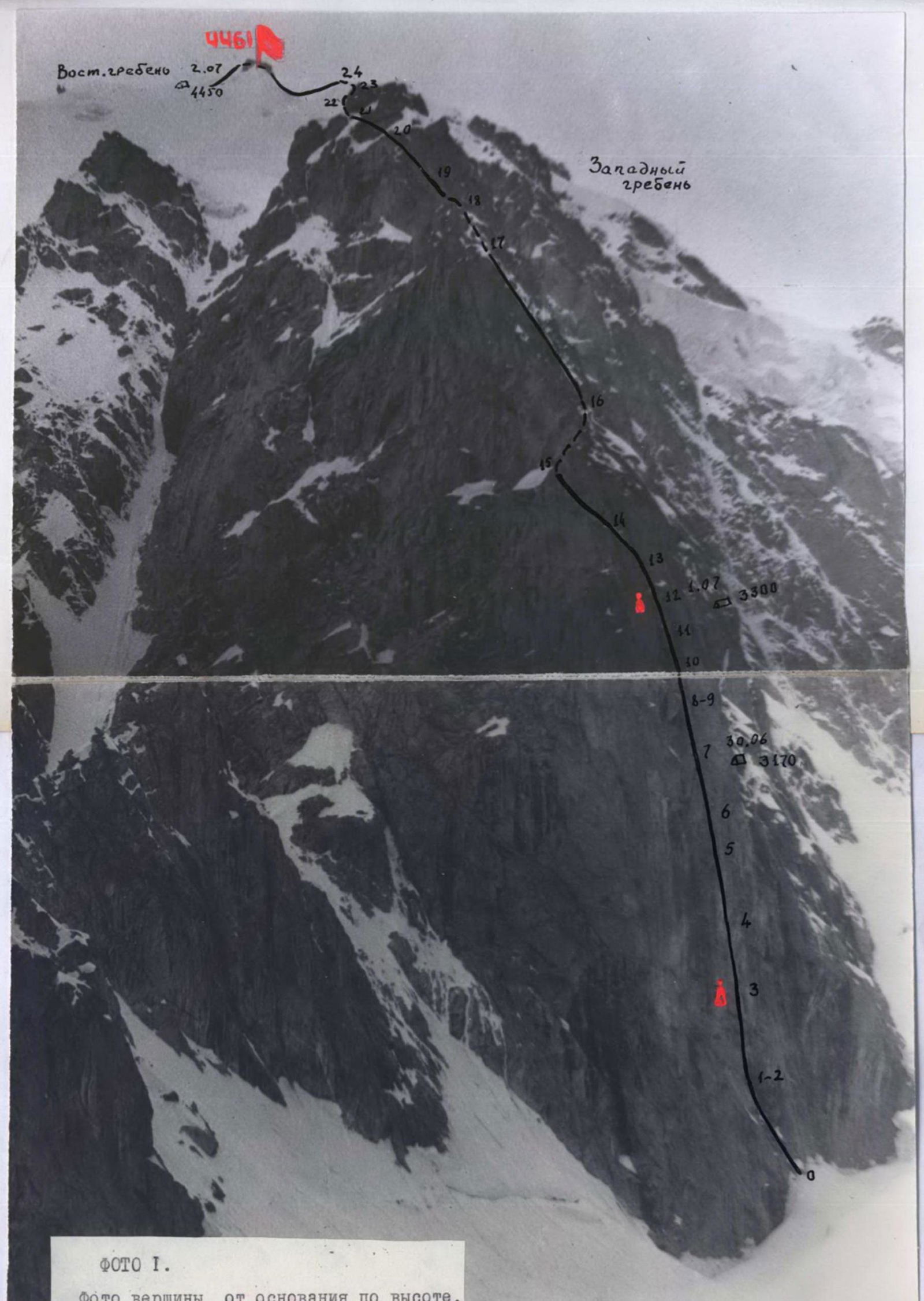
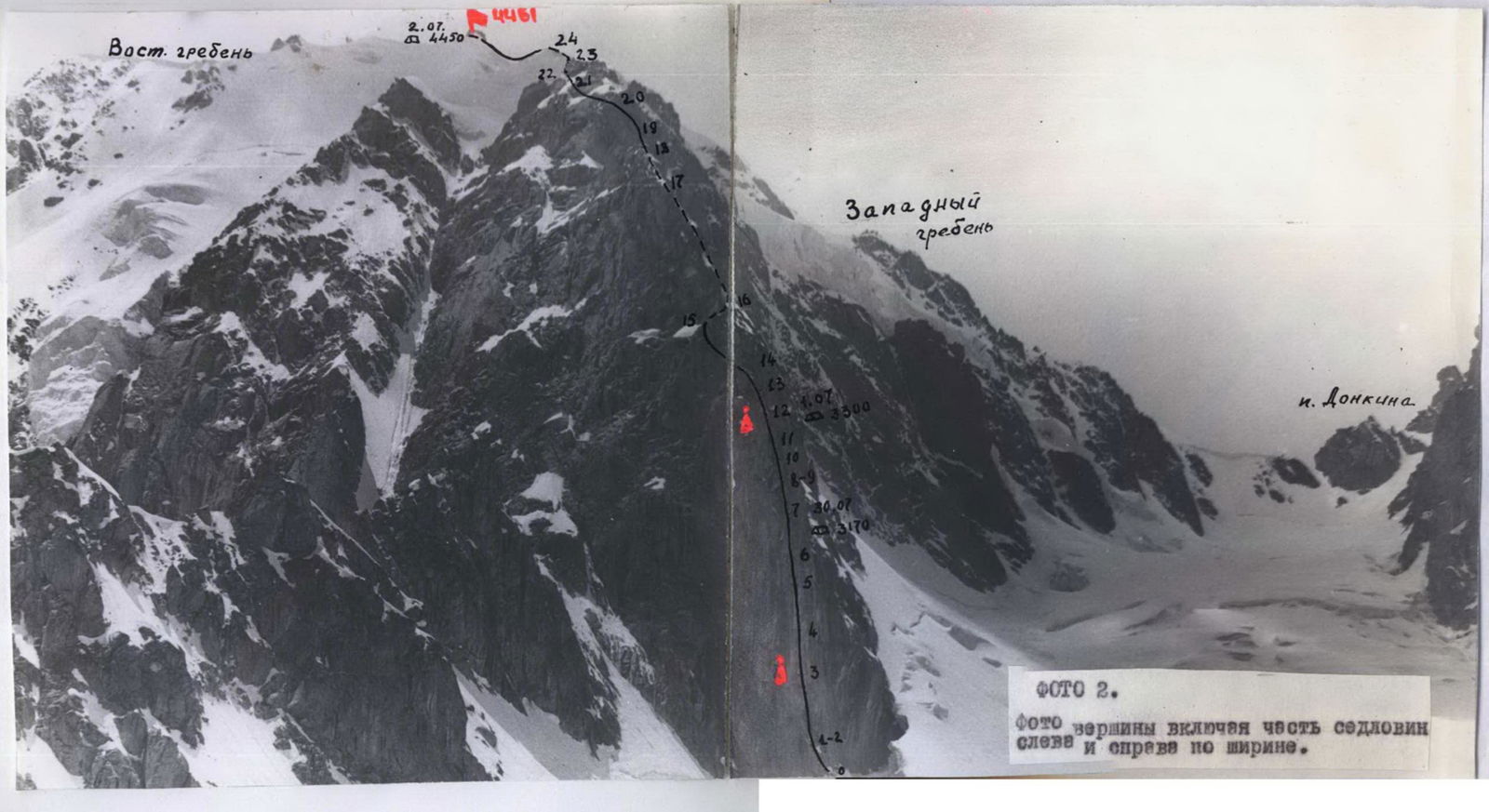
PHOTO 2. Photo of the summit including part of the saddles on the left and right by width.
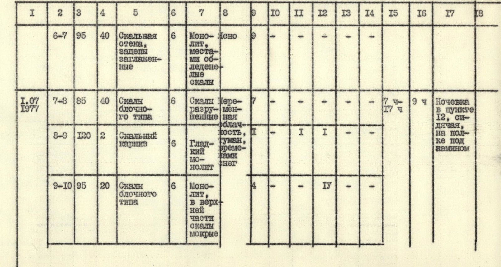
Continuation of Table I
 | I | 2 | 3 | 4 | 5 | 6 | 7 | 8 | 9 | 10 | 11 | 12 | 13 | 14 | 15 | 16 | 17 | 18 |
| :----------- | :------- | :-- | :-- | :--------------------------------------------------- | : | :---------------------------------- | :-------------------- | :-- | :-- | :-- | :-- | :-- | :-- | :-------------- | :-- | :---------------------------------------------------------------------------------------------------------------------------------------------------------------------------------------------------------------------------------------------------------- | :------------------- |
| 30.06 1977 | R2–R3 | 95 | 40 | Rocks with few holds, wide crack | 6 | Monolith | Clear | 6 | - | 2 | VII | - | - | 4 ч – 18:30 | | 14 ч | Overnight stay at R7 in hammocks |
| | R3–R4 | 93 | 50 | Rock wall with few holds, narrow vertical cracks | 6 | Monolith | | 6 | - | 2 | VIII | - | - | | | | |
| | R4–R5 | 90 | 50 | Rock wall with few small holds | 6 | Monolith | | 7 | - | I | У | - | - | | | | |
| | R5–R6 | 95 | 20 | Rock wall, smooth holds | 6 | Monolith | | 4 | - | - | у | - | - | | | | |
| | R6–R7 | 95 | 40 | Rock wall, smooth holds | 6 | Monolith, partly icy rocks | Clear | 9 | - | - | - | - | - | | | | |
| 1.07 1977 | R7–R8 | 85 | 40 | Blocky rocks | 6 | Broken rocks | Variable cloudiness | 7 | - | - | - | - | - | 7 ч – 17:00 | 9 ч | Overnight stay at R12, sitting on a shelf under a chimney | |
| | R8–R9 | 120 | 2 | Rock cornice | 6 | Smooth monolith, occasional snow | Fog | I | - | I | I | - | - | | | | |
| | R9–R10 | 95 | 20 | Blocky rocks | 6 | Monolith, wet rocks in upper part | | 4 | - | - | IV | - | - | | | | |
| 2.07 1977 | R10–R11 | 90 | 20 | Rock wall with few small holds | 6 | Monolith | | 4 | - | - | - | - | - | | | | |
| | R11–R12 | 80 | 40 | Wall, "polished rocks" | 6 | Monolith | | 7 | - | - | - | - | - | | | | |
| | R12–R13 | 85 | 40 | Chimney | 5 | Monolith | Variable cloudiness | 16 | - | - | - | - | - | 4 ч – 21:00 | 16 ч | Overnight stay during descent slightly below the summit on a wide snowy ridge in a tent; Starting from section R14–R15 and up to section R20–R21, the route bypasses the gendarmes along the walls of the NE ridge | |
| | R13–R14 | 80 | 40 | Slabs | 5 | Snowy monolith | | 7 | - | - | - | - | - | | | | |
| | R14–R15 | 45 | 140 | Narrow ledges, small rock walls | 4 | Snowy, icy monolith | | 13 | Available ledges for belaying | | | | | | | | |
| | R15–R16 | 60 | 50 | Ice couloir | 5 | Flow ice | | 3 | 5 | ledges | | | | | | with an average slope of 60°–80°; in column 6, related to these sections, the slope is written | |
| | R16–R17 | 30 | 200 | Ledges, small rock walls | 4 | Monolith, sometimes "live rocks", partly snowy, icy | | 18 | ledges | | | | | | | | |
| | R17–R18 | 50 | 50 | Couloir | 3 | Heavily snowy, flow ice in upper part | | 3 | ledges, belay via ice axe | | | | | | | | |
| | R18–R19 | 75 | 50 | Walls alternating with narrow ledges | 3 | Snowy monolith | | 5 | ledges | | | | | | | | |
| | R19–R20 | 80 | 100 | Walls, ledges, slabs | 4 | Monolith | | 14 | - | - | - | - | - | | | | |
| | R20–R21 | 45 | 150 | Rock ledges, small walls | 4 | Snowy monolith | | 15 | ledges | | | | | | | | |
| | R21–R22 | 45 | 60 | Couloir | 4 | Edge of ice and rocks, flow ice | | 7 | 2 | - | - | - | - | | | | |
| | R22–R23 | 30 | 100 | Ridge | 3 | Snow-ice | | belay via ice axe | | | | | | | | | |
| | R23–R24 | 60 | 60 | Ice pitch | 5 | Ice, partly flow | | - | 8 | - | - | II | - | | | | |
| | R24–R25 | 20 | 500 | Ridge | 2 | Snowy, snowdrifts, cornices | | simultaneous belay | | | | | | | | | |
| 3.07 1977 | Descent | via | route | 2B cat. diff. — Eastern ridge | | | | | | | | | | 7 ч – 18:30 | | to the glacier 1.5 ч to the tourist camp | Tourist camp Djailyk, 16 ч 30 мин |
| I | 2 | 3 | 4 | 5 | 6 | 7 | 8 | 9 | 10 | 11 | 12 | 13 | 14 | 15 | 16 | 17 | 18 |
| :----------- | :------- | :-- | :-- | :--------------------------------------------------- | : | :---------------------------------- | :-------------------- | :-- | :-- | :-- | :-- | :-- | :-- | :-------------- | :-- | :---------------------------------------------------------------------------------------------------------------------------------------------------------------------------------------------------------------------------------------------------------- | :------------------- |
| 30.06 1977 | R2–R3 | 95 | 40 | Rocks with few holds, wide crack | 6 | Monolith | Clear | 6 | - | 2 | VII | - | - | 4 ч – 18:30 | | 14 ч | Overnight stay at R7 in hammocks |
| | R3–R4 | 93 | 50 | Rock wall with few holds, narrow vertical cracks | 6 | Monolith | | 6 | - | 2 | VIII | - | - | | | | |
| | R4–R5 | 90 | 50 | Rock wall with few small holds | 6 | Monolith | | 7 | - | I | У | - | - | | | | |
| | R5–R6 | 95 | 20 | Rock wall, smooth holds | 6 | Monolith | | 4 | - | - | у | - | - | | | | |
| | R6–R7 | 95 | 40 | Rock wall, smooth holds | 6 | Monolith, partly icy rocks | Clear | 9 | - | - | - | - | - | | | | |
| 1.07 1977 | R7–R8 | 85 | 40 | Blocky rocks | 6 | Broken rocks | Variable cloudiness | 7 | - | - | - | - | - | 7 ч – 17:00 | 9 ч | Overnight stay at R12, sitting on a shelf under a chimney | |
| | R8–R9 | 120 | 2 | Rock cornice | 6 | Smooth monolith, occasional snow | Fog | I | - | I | I | - | - | | | | |
| | R9–R10 | 95 | 20 | Blocky rocks | 6 | Monolith, wet rocks in upper part | | 4 | - | - | IV | - | - | | | | |
| 2.07 1977 | R10–R11 | 90 | 20 | Rock wall with few small holds | 6 | Monolith | | 4 | - | - | - | - | - | | | | |
| | R11–R12 | 80 | 40 | Wall, "polished rocks" | 6 | Monolith | | 7 | - | - | - | - | - | | | | |
| | R12–R13 | 85 | 40 | Chimney | 5 | Monolith | Variable cloudiness | 16 | - | - | - | - | - | 4 ч – 21:00 | 16 ч | Overnight stay during descent slightly below the summit on a wide snowy ridge in a tent; Starting from section R14–R15 and up to section R20–R21, the route bypasses the gendarmes along the walls of the NE ridge | |
| | R13–R14 | 80 | 40 | Slabs | 5 | Snowy monolith | | 7 | - | - | - | - | - | | | | |
| | R14–R15 | 45 | 140 | Narrow ledges, small rock walls | 4 | Snowy, icy monolith | | 13 | Available ledges for belaying | | | | | | | | |
| | R15–R16 | 60 | 50 | Ice couloir | 5 | Flow ice | | 3 | 5 | ledges | | | | | | with an average slope of 60°–80°; in column 6, related to these sections, the slope is written | |
| | R16–R17 | 30 | 200 | Ledges, small rock walls | 4 | Monolith, sometimes "live rocks", partly snowy, icy | | 18 | ledges | | | | | | | | |
| | R17–R18 | 50 | 50 | Couloir | 3 | Heavily snowy, flow ice in upper part | | 3 | ledges, belay via ice axe | | | | | | | | |
| | R18–R19 | 75 | 50 | Walls alternating with narrow ledges | 3 | Snowy monolith | | 5 | ledges | | | | | | | | |
| | R19–R20 | 80 | 100 | Walls, ledges, slabs | 4 | Monolith | | 14 | - | - | - | - | - | | | | |
| | R20–R21 | 45 | 150 | Rock ledges, small walls | 4 | Snowy monolith | | 15 | ledges | | | | | | | | |
| | R21–R22 | 45 | 60 | Couloir | 4 | Edge of ice and rocks, flow ice | | 7 | 2 | - | - | - | - | | | | |
| | R22–R23 | 30 | 100 | Ridge | 3 | Snow-ice | | belay via ice axe | | | | | | | | | |
| | R23–R24 | 60 | 60 | Ice pitch | 5 | Ice, partly flow | | - | 8 | - | - | II | - | | | | |
| | R24–R25 | 20 | 500 | Ridge | 2 | Snowy, snowdrifts, cornices | | simultaneous belay | | | | | | | | | |
| 3.07 1977 | Descent | via | route | 2B cat. diff. — Eastern ridge | | | | | | | | | | 7 ч – 18:30 | | to the glacier 1.5 ч to the tourist camp | Tourist camp Djailyk, 16 ч 30 мин |
Route Description
From the bivouac on the Djailyk glacier to the base of the 400-meter wall, which the steep north-eastern ridge of Chegem peak drops to the north-east, is about 300 meters. Almost through the entire wall, an internal corner with a wide crack passes obliquely (70°–80°) from right to left at the junction of the side walls. The path goes through a wide bergschrund at the base of the wall, and then along steep, broken rocks for 40 m to a three-meter rock cornice, from which the internal corner with a crack begins. When approaching the cornice, there are many loose, protruding rocks, some of which are iced. Very difficult free climbing. The cornice is overcome on ladders. Further along the wide crack of the overhanging internal corner, sometimes using artificial holds (climbing is extremely difficult), move in the direction of a large stone, seemingly attached to the internal corner, shaped like a long parallelepiped. At the top of the stone, there is a small platform for one person — a convenient place to pull up backpacks (first control point). From the cornice, 40–50 m. Then, along the right wall of the internal corner and further, exiting the corner (since at this point the corner is already starting to be flooded with water and the wide crack becomes smooth and inconvenient for climbing), along smooth, overhanging yellow rocks with narrow vertical cracks for 50 m. Gradually, the overhang turns into a sheer drop, and the relief remains the same. The path is vertically upwards, gradually bearing to the right, since there are large cracks on the right, convenient for driving pitons, under overhanging gray, rough rocks with smoothed but large holds. From the first control point, about 100 m (climbing is extremely difficult, often using artificial holds). Further vertically upwards and slightly to the left (about 70°) along overhanging gray rocks. Extremely difficult free climbing, dangerous because the cracks for driving pitons are often clogged with limestone. After 40 m, there is an exit to a system of small ledges, making it possible to stand and quickly organize a place for an overnight stay in hammocks. From the start of the route — 12–14 climbing hours. From the overnight stay, 40 m — movement along steep, broken rocks of blocky type (loose rocks) to a 2-meter rock cornice, which is overcome on ladders and leads to an overhang in the form of monolithic blocks with narrow vertical and horizontal cracks. Climbing is extremely difficult, very small holds, sometimes artificial holds are used, then the overhang turns into a sheer drop, and then into monolithic steep rocks, iced in the upper part. The path from the cornice is vertically upwards 80–90 m to a small platform at the base of a 40-meter chimney with smooth walls. From the overnight stay in hammocks, 6–7 hours. On the platform, a sitting overnight stay can be organized. Second control point. Further up the chimney for 40 m and then left upwards along icy steep slabs to the exit to the shoulder of the north-eastern ridge. On the shoulder — platforms for a tent. Further movement along narrow snowy ledges, 140–150 m in the direction of the saddle between R1 and R2 huge gendarmes of the ridge. Climbing queue is difficult, especially when moving from ledge to ledge. The exit to the saddle is along a steep narrow ice couloir (ice is flow) — about 50 m. Bypassing the R2 gendarm on the right along rocks of above average difficulty and snowy narrow ledges for 200 m with a height gain at an angle of 30°–40°. The exit to the saddle between R2 and R3 gendarmes is along a steep snow-ice couloir of average difficulty for 50 m upwards to the left, from the sitting overnight stay for 8–9 hours. Further along rocks of average difficulty, and then along rocks of above average difficulty and partly difficult rocks, ascent upwards to the left for 150 m to the shoulder of R3 gendarm. Bypassing R3 gendarm along rocks of above average difficulty on the left with a height gain at an angle of 45°. Further to the right upwards for 60 m along the edge of ice and rocks, to the exit to the ice ridge leading to a steep 60-meter ice pitch (ice is partly flow). Behind the pitch — a long snowy ridge (cornices!), leading to the summit of Chegem. From the saddle between R2 and R3 gendarmes, 6–7 hours. Descent along the eastern ridge, route 2B cat. diff.
PHOTO 4. Photo of the route profile from the side of Donkin pass.
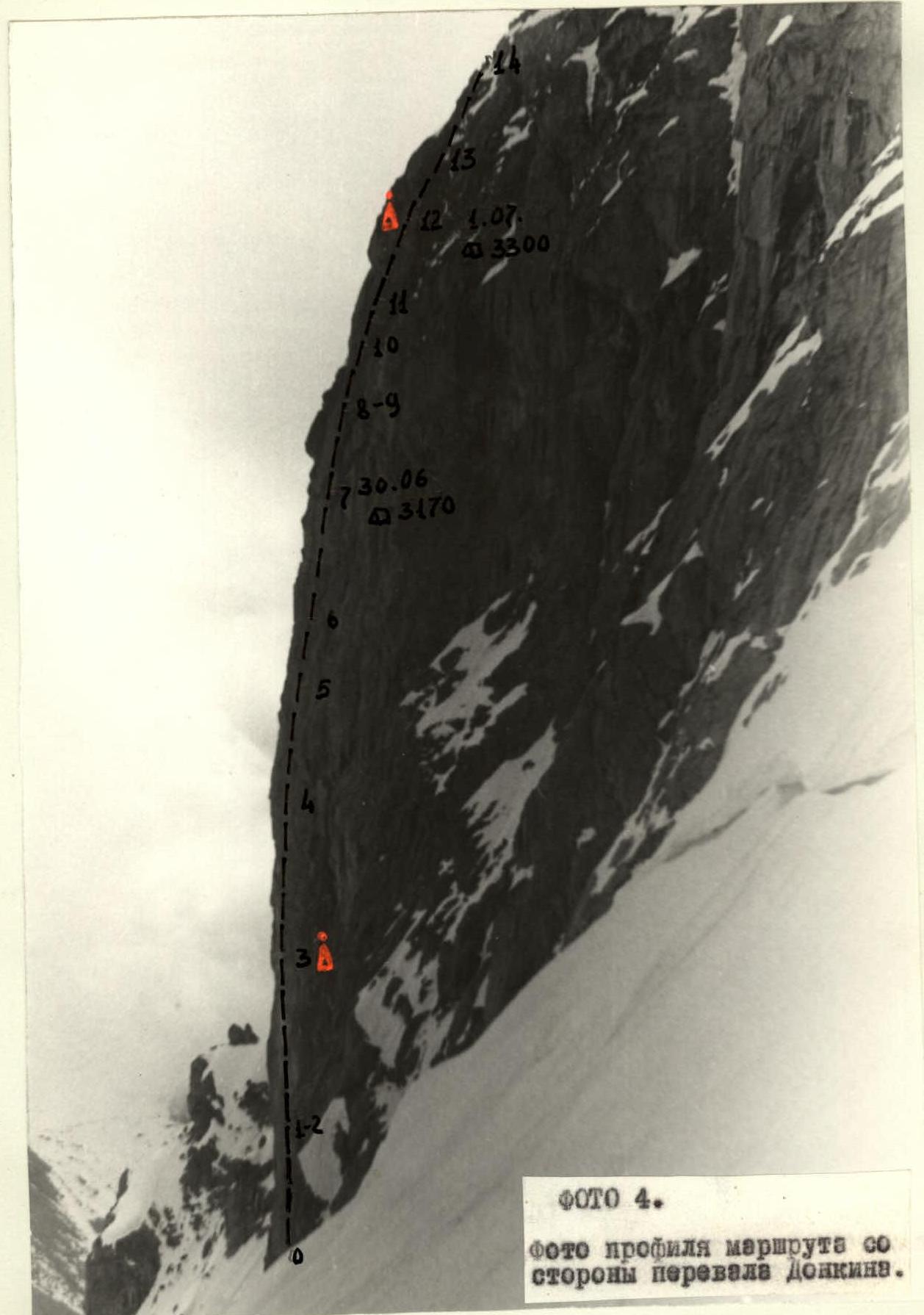
PHOTO 3. Photo of the general view of the route.
PHOTO 5. Photo of the route profile from the side of Chegem gorge.
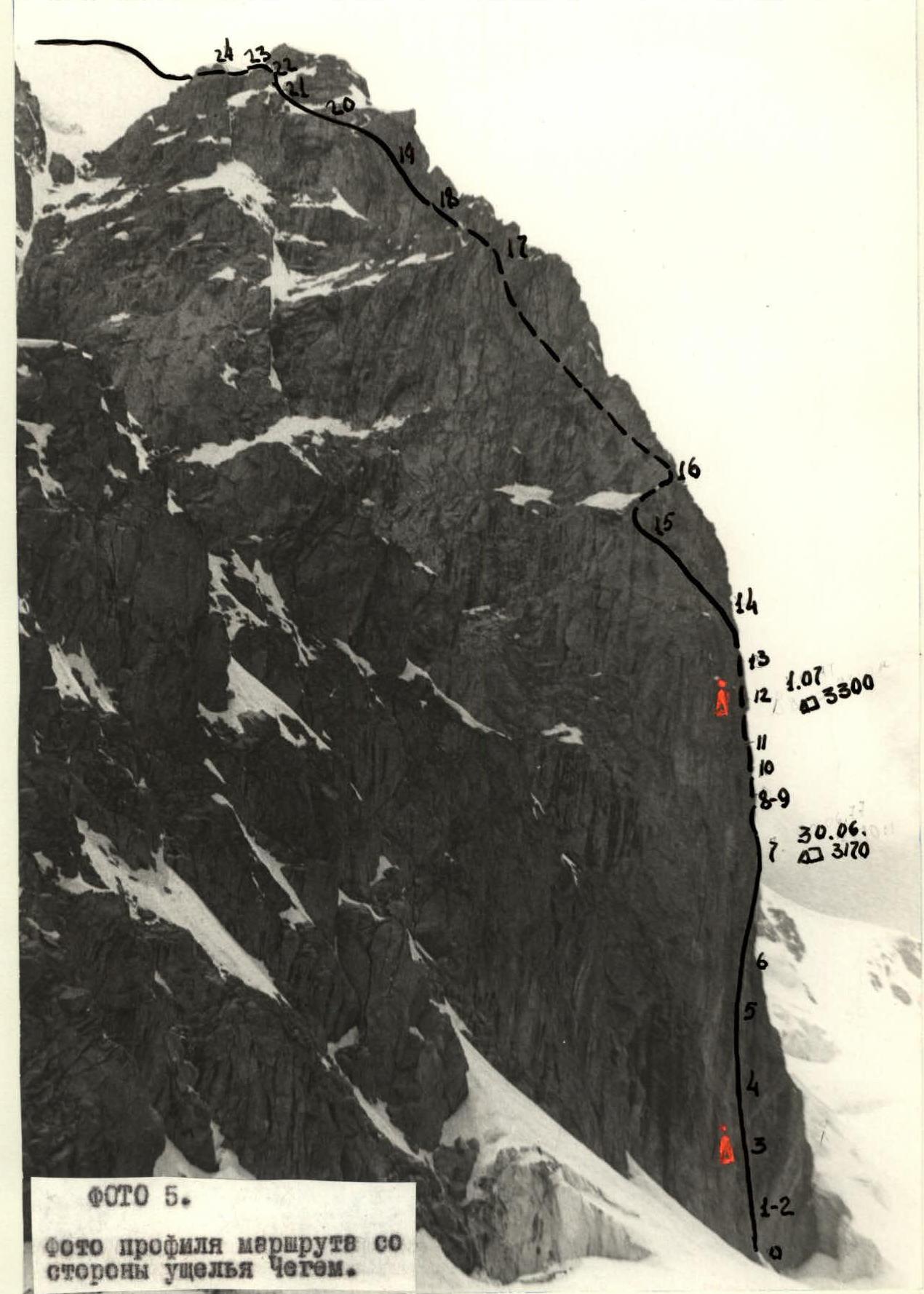
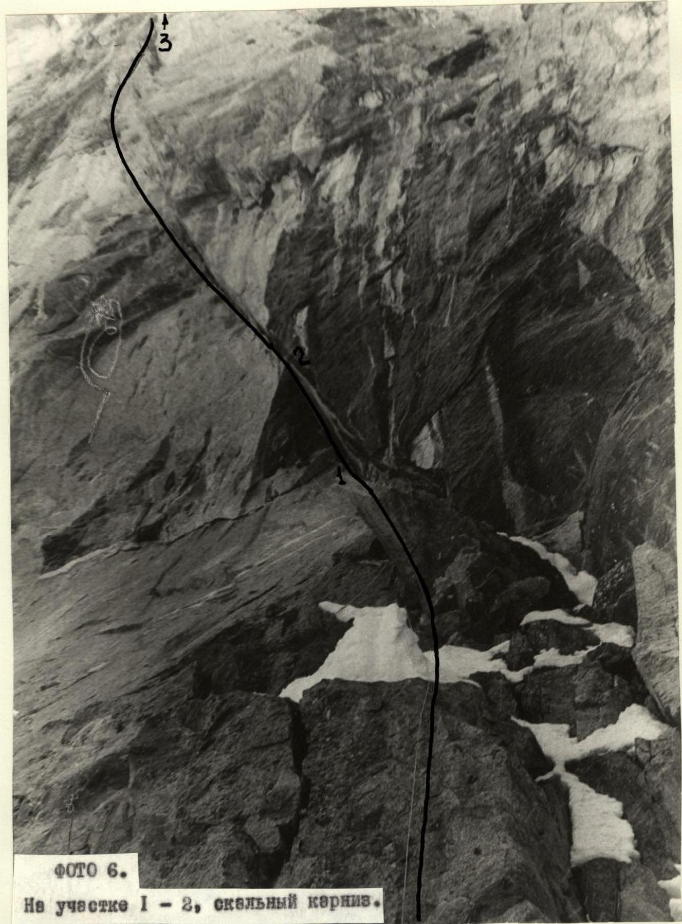
PHOTO 6. On section R1–R2, rock cornice.