ASCENT DOCUMENT
- Ascent class: combined.
- Ascent area: spurs of the Main Caucasian Range from the Chipperazau Pass to the Kitlod Pass.
- Peak, its height, and ascent route: Ullutau Main, 4207 m, via the center of the Northwest wall through the "Rocky Island".
- Estimated difficulty category: 5B
- Route characteristics: a) height difference – 900 m, b) average steepness – 65°, c) section lengths: III difficulty category – 670 m, IV difficulty category – 1360 m, V difficulty category – 650 m.
- Number of pitons: For belaying:
- Rock 38
- Ice 98
- Bolt 2 For creating ITO:
- Rock 3
- Ice 5
- Bolt —
- Number of climbing hours: 38 hours
- Number of bivouacs and their characteristics: two bivouacs.
- 1st sitting on a ledge
- 2nd sitting on a ridge in a tent
- Surname, initials of participants, and their sports qualification:
- Li Vladimir Nikolaevich, Candidate for Master of Sports of the USSR
- Krasnenko Sergey Georgievich, Candidate for Master of Sports of the USSR
- Team coach — Master of Sports of the USSR, 1st category instructor Petukhov V.P.
- Date of departure and return: August 21–23, 1981.
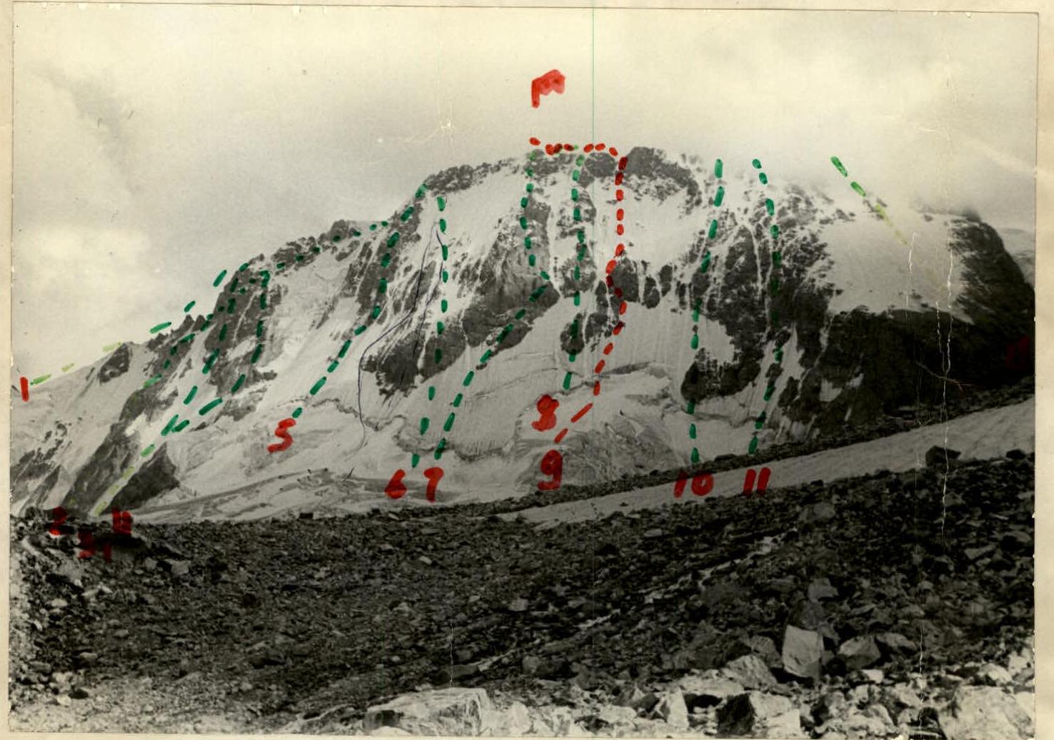
List of routes on the general view photograph of the peak:
- Ullutau V. from Mestia Pass (A. Zolotarev) — 3B difficulty category.
- Ullutau V. via NE edge of Eastern shoulder (A. Naumov) — 5B difficulty category.
- Ullutau V. via North wall of Eastern shoulder (O. Chernoslivin) — 5B difficulty category.
- Ullutau V. via right edge of North wall of Eastern shoulder (V. Artyomonov) — 5B difficulty category.
- Ullutau V. via right edge of North wall (E. Manucharov) — 5B difficulty category.
- Ullutau V. via rocky islands of North wall — (O. Chernoslivin) — 5B difficulty category.
- Ullutau Main via North wall (V. Abalakov) — 5B difficulty category.
- Ullutau Main via rocky islands of North wall and Western ridge (V. Maltsev) — 5B difficulty category.
- Ullutau Main through rocky "Island" — first ascent route.
- Ullutau Main via North wall through "Crab" (D. Laskavy) — 5B difficulty category.
- Ullutau West via North wall (E. Lipen) — 5A difficulty category.
- Ullutau West via Northwest wall (L. Gudkov) — 4B difficulty category.
Brief explanation of the route passage table by sections.
From "Cheget bivouacs" exit to Ullutau glacier and along its plateau (closed crevasses), not reaching "Central platforms", turn right under Ullutau North wall, where the slope steepness is 35° and gradually increases, and reach the bergschrund. Overcome it with the help of artificial points of support (6 m).
Then ascend the hanging ice slope in the direction of the "tail" of the rocky island (Section R1, 160 m).
Next, move along the rocks, covered with ice, to a sloping ledge (Section R2, 70 m). From the ledge, move straight up to the right to an internal corner. Without entering the internal corner, move left along the rocks of medium difficulty to a small ledge for two people (Section R3–R4, 130 m).
Then, along a vaguely expressed edge of the rocky island, exit to a small ledge (Section R5). Bivouac! Control point!
After the bivouac:
- Bypass the rocky tower on the left along a steep ice slope (Section R6, 40 m);
- Then, along the ice slope, reach a small triangular tower (Section R7, 300 m);
- Then move up to the right in the direction of the "Iron" gendarme rocks;
- Rocks fall from the saddle between "Rhombus" and "Iron" gendarmes (Section R8, 60 m);
- Then, along the rocks of medium difficulty, move left and up towards a chimney (Section R9, 40 m).
The chimney has "live" rocks, turns into a monolith at the top, water flows, and climbing becomes more complicated. From the upper part of the chimney, move left and exit slightly above the saddle between two gendarmes (Section R10, 35 m).
Bivouac on the ridge. Then follow the route of 4A difficulty category to the summit of Ullutau Main. Descent along the ridge to Garvash Pass via the route of 4A difficulty category.
Table of main characteristics of the ascent route.
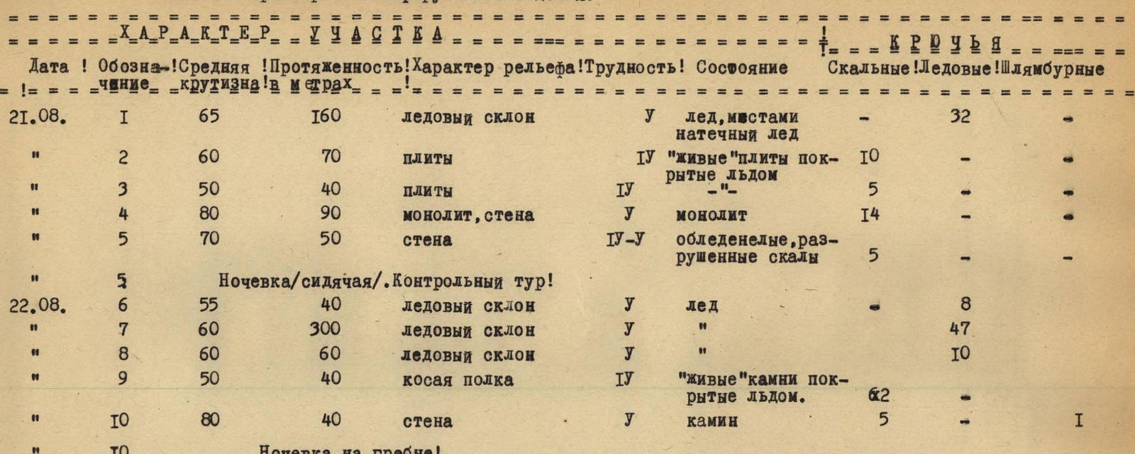
| Date | Section designation | Average steepness | Length in meters | Terrain type | Difficulty | Condition | Rock | Ice | Bolt |
|---|---|---|---|---|---|---|---|---|---|
| 21.08. | R1 | 65° | 160 | ice slope | 5 | ice, partially hanging ice | — | 32 | — |
| R2 | 60° | 70 | slabs | 4 | "live" slabs, covered with ice | 10 | — | — | |
| R3 | 50° | 40 | slabs | 4 | — | 5 | — | — | |
| R4 | 80° | 90 | monolith, wall | 5 | monolith | 14 | — | — | |
| R5 | 70° | 50 | wall | 4–5 | icy, destroyed rocks | 5 | — | — | |
| Bivouac (sitting). Control point! | |||||||||
| 22.08. | R6 | 55° | 40 | ice slope | 5 | ice | — | 8 | — |
| R7 | 60° | 300 | ice slope | 5 | — | — | 47 | — | |
| R8 | 60° | 60 | ice slope | 5 | — | — | 10 | — | |
| R9 | 50° | 40 | sloping ledge | 4 | "live" rocks, covered with ice | — | 2 | — | |
| R10 | 80° | 40 | wall | 5 | chimney | 5 | — | 1 | |
| Bivouac on the ridge! | |||||||||
| 23.08 | Ridge, summit, ridge, Garvash Pass, "Cheget bivouacs" — Ullutau tourist base. |
 0.6 × 80° A