1991 RSFSR Alpine Championship. Winter Ascension Class 135
Report
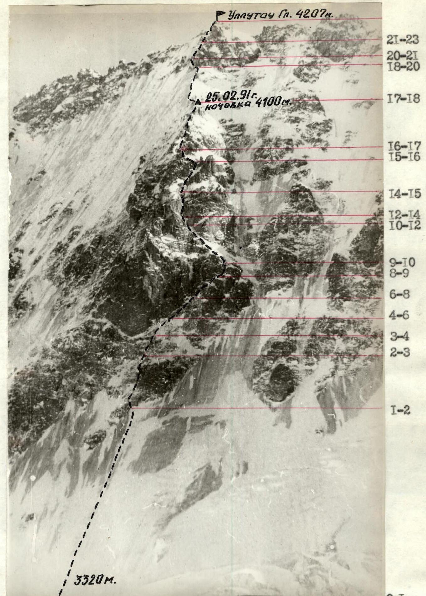
Report on the ascent to Ullu-Tau peak (Main) 4207 m via the north wall, category 5B, Abalakov's route '51. 2.4.1.132 KTMGV
Team from "Rodina" Sports Club of the Kirov Regional Committee for Physical Culture and Sports.
Team Leader
Coach 
Shabalin P.E. Mashkovtsev V.I.
"Rodina" Sports Club: 610006, Kirov, Lepsye St., 4A, ph. 30310, 36592
Team Leader: Shabalin Pavel Eduardovich, 610001, Kirov, Nekrasova St., 6A, apt. 36, ph. 41034
Coach: Mashkovtsev Vladimir Ivanovich, Kirov, Lenin St., 63/12, apt. 3
Tactical Actions of the Team
For ease of comparison, we compiled a table with the planned time breakdown and the actual schedule of the route.
| Time Breakdown | Actual Schedule | Reasons for Deviations from the Tactical Plan |
|---|---|---|
| 4:00 — departure to the route from the bivouac. | 4:00 — departure to the route from the bivouac. | — |
| 8:00 — "Romb" rock formation. | 7:50 — team working near "Romb". | — |
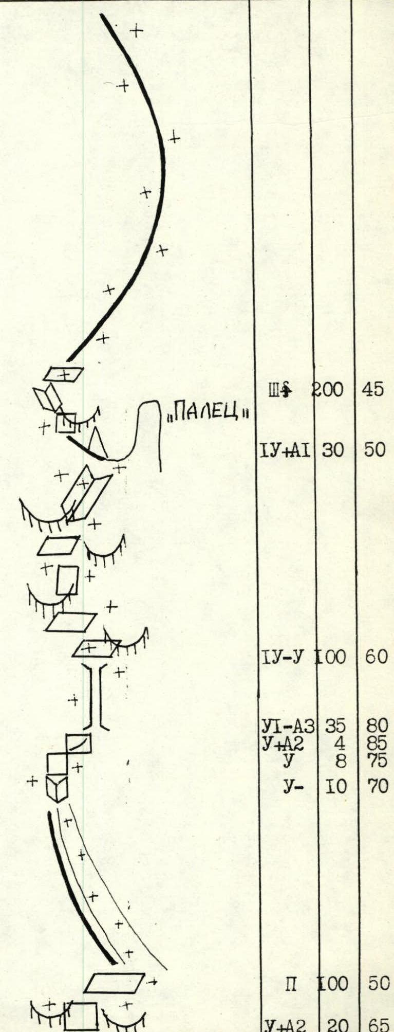
| 15:00 — "Palets" rock formation. | 16:00 — team reaches "Palets". | 1-hour delay due to icy, snow-covered rocks. |
| 18:00 — summit, overnight stay. | 19:00 — summit. | — |
| — | 20:00 — overnight stay on the ridge. | 2-hour delay due to weather. Very cold, strong wind from the south. Clear, good visibility. 5 rope lengths descent to a platform on a snowy ridge under the protection of a large boulder. This overnight stay was recommended by the rescue team leader Petukhov V.P. |
| 8:00 — start of descent. | 8:20 — start of descent. | — |
| 16:00 — Ullu-Tau glacier. | 18:00 — team descended to the glacier. | 2-hour delay from the planned due to a sharp deterioration in weather: heavy snowfall, zero visibility, snow sliding down the wall forced a safer, not the shortest, descent route. |
The excess of actual travel time over the planned does not exceed 20% of the allowed.
The interaction and composition of the rope teams fully corresponded to the tactical plan. The change of leaders was carried out according to the tactical plan. Due to icy rocks and very hard ice, it was necessary to belay more frequently for safety reasons. The first climber went on a double rope, one of which was "Elite" — 1 UIAA. The rest followed on the rope with top belay. For the safety of the first climber, rock and ice screws, chocks, and nylon slings were used in the necessary quantity and assortment. The movement on the route was facilitated by properly selected equipment: all participants wore plastic, stiff boots and crampons with a stiff platform "footfangs," and used "Jumar" and "Petzl" ascenders. The experience of traversing the "Bezen-Zengi" area routes helped solve the problem of moving the first climber on iced rocks — using crampons and ice axes as skyhooks. Most of the route was climbed using free climbing. The chimney was climbed using artificial aids (ITO) and required, in winter conditions, the application of all high-altitude climbing techniques. Belay stations were always organized on at least two blocked points. The team left the route "clean" — all "their" pitons were removed on the ascent.
The tactical plan was designed so that the most difficult sections R2–R5 were climbed during daylight. The overnight stay was organized on a convenient 2 × 2 m platform with belay on pitons. It was protected from the wind by a large boulder and a snowy ridge, ensuring a good rest before the descent. Hot meals were organized twice a day, and during the day, each participant used an individual snack. There were no falls, injuries, or frostbite. In bad weather, the entire team efficiently carried out the descent on ice near the Chernoslivin's route, twisting out ice screws. Members of the rescue team observed the team on the route through the optical tube of the "Ullu-Tau" camp. There were no issues with communication organization. The audibility was "five." Communication sessions were quick and did not interfere with work on the route. The rescue team was in the AUSB "Ullu-Tau," 3.5–4 hours walking distance from the start of the route.
During the ascent, the team made every effort to clean up the route. All bags, fuel containers, and other trash were brought down to the "Ullu-Tau" camp.
The route was climbed with a significant reserve of strength, despite unfavorable weather conditions and the challenging state of the route.
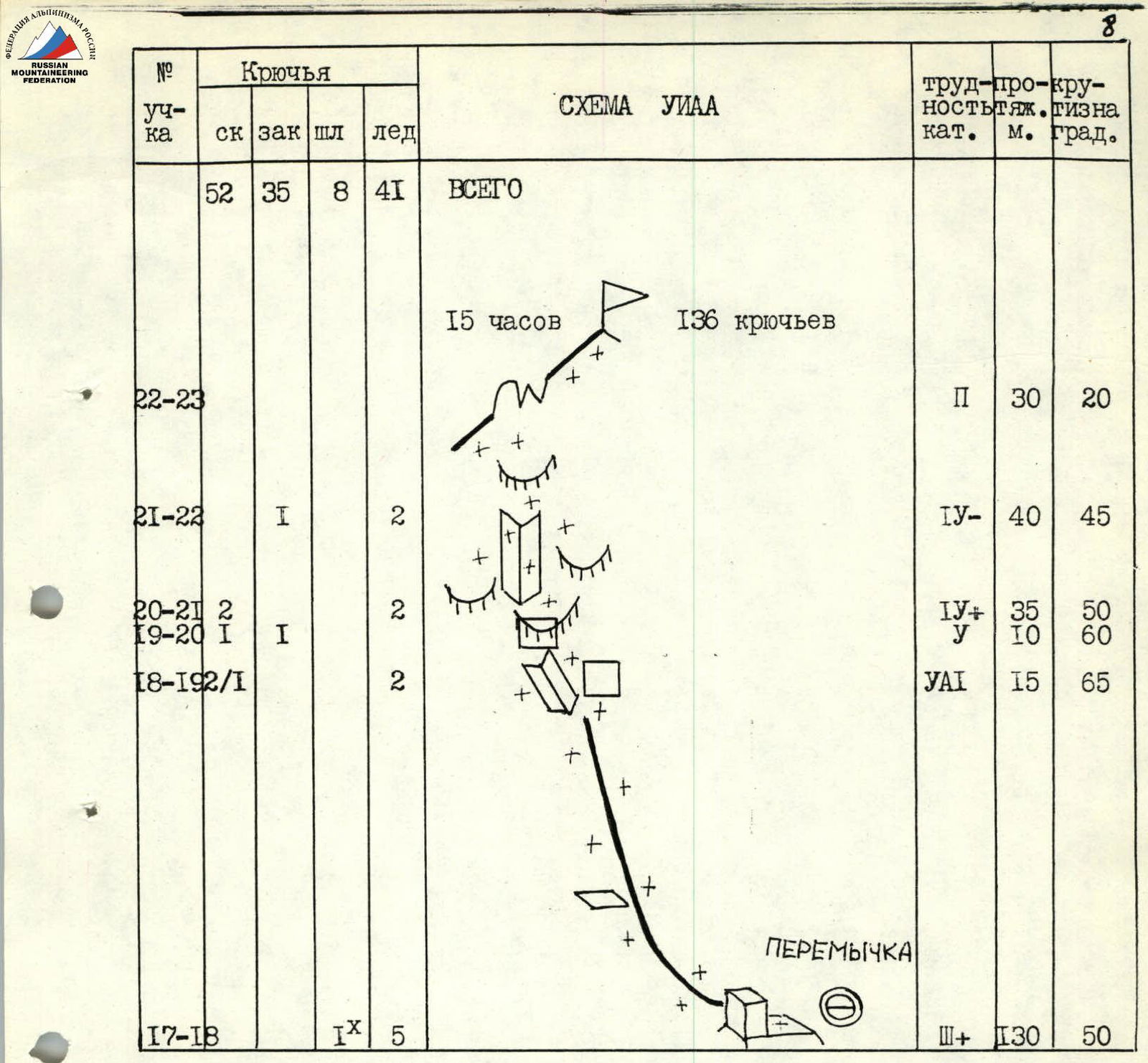
| № (sect.) | rock | chocks | pitons | ice | UIAA SCHEME | difficulty cat. | length m | steepness deg. |
|---|---|---|---|---|---|---|---|---|
| 7–8 | 3 | 1 | 2 |  | 4–5 | 35 | 45 | |
| 6–7 | 2/1 | 5+ ITO A1 | 10 | 65 | ||||
| 5–6 | 3 | 1 |  | 4–5 | 30 | 50 | ||
| 4–5 | 2/1 | 2 | 5+ ITO A1 | 15 | 70 | |||
| 3–4 | 2 | 3 | 4 | 30 | 50 | |||
| 2–3 | 3 | 1 | 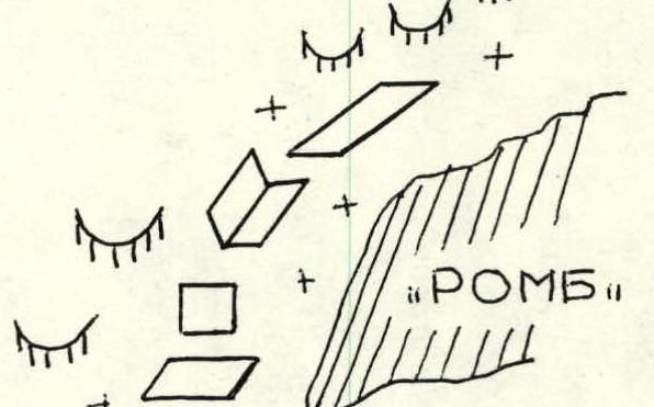 | 4–5 | 35 | 50 | ||
| 1–2 | 7 | 2 | 4 |  | 4–5 | 80 | 60 | |
| 0–1 | 20 | 4 | 300 | 40 | ||||
| 16–17 | 2 | 7 | 1 | 3+ | 200 | 45 | ||
| 15–16 | 3/1 | 2 | 4+ ITO A1 | 30 | 50 | |||
| 14–15 | 6 | 4 | 2 | 4–5 | 100 | 60 | ||
| 13–14 | 7/5 | 3/2 | 1 | 6 ITO A3 | 35 | 80 | ||
| 12–13 | 3/2 | 1 | 5+ ITO A2 | 4 | 85 | |||
| 11–12 | 1 | 5 | 8 | 75 | ||||
| 10–11 | 2 | 5 | 10 | 70 | ||||
| 9–10 | 1 | 4 | 2 | 2 | 100 | 50 | ||
| 8–9 | 2 | 2 | 2 | 5+ ITO A2 | 20 | 65 | ||
| 22–23 | 2 | 2 | 30 | 20 | ||||
| 21–22 | 1 | 2 | 4– | 40 | 45 | |||
| 20–21 | 2 | 2 | 4+ | 35 | 50 | |||
| 19–20 | 1 | 1 | 5 | 10 | 60 | |||
| 18–19 | 2/1 | 2 | 5 ITO A1 | 15 | 65 | |||
| 17–18 | 1 | 5 | 3+ | 130 | 50 | |||
| TOTAL | 52 | 35 | 8 | 41 | 15 hours 136 pitons |
Route Description by Sections
R0–R1: Snow-ice slope above the bergschrund 300 m, 4, 40°. Very hard ice. Spalls off in lenses. Movement on belays.
R1–R2: Rocks on the left side of the "Romb". Impossible to bypass on ice. Ice lies on "ram's foreheads," and ice screws only twist in a third. Rocks are complex, iced. Very difficult to organize reliable belay. Climbing in crampons and with ice axes. 80 m, 4–5, 60°.
R2–R3: Left of the "Romb" on iced "ram's foreheads" to the base of the wall. 35 m, 4–5, 50°.
R3–R4: Traverse under the base of the wall to the right to an internal corner. Incrusted ice on rocks. Problems with belay organization — ice spalls off. 30 m, 4, 50°.
R4–R5: Exit to a system of sloping shelves on the internal corner. Very complex in winter conditions. Monolithic rocks are iced, only "live" rock sticks out of the ice. Very careful climbing. As on the entire route — problems with organizing a reliable belay. 15 m, 5+ ITO A1, 70°.
R5–R9: System of sloping rock-rubble shelves like "ram's foreheads," iced and snow-covered, interspersed with short complex walls. In winter conditions, both are problematic. It is necessary to use pitons as ITO, including old pitons. Climbing only in crampons. At sub-zero temperatures, constantly using ice axes as skyhooks in gloves. 95 m, 4–5+ ITO A2, 45°–65°.
R9–R10: Left up a snowy couloir — gully 100 m, 2, 50° towards the chimney. Ice under deep snow. Belay on rocks on the left side of the gully.
R10–R11: Couloir turns into a steep internal corner. Live blocks, slabs! 10 m to the left is a snow-covered platform for a tent. 10 m, 5-, 70°.
R11–R12: Without reaching the platform, traverse right on the wall 8 m, 5, 75° and organize a stance on a boulder.
R12–R13: Entrance to the chimney through a 4 m wall 5+ ITO A2, 85°. ITO.
R13–R14: Chimney is iced. No sun — very cold. Climbing in crampons with ice axes. On abseils, it doesn't work out — the chimney's walls are smooth, crampons don't stand. Without crampons at sub-zero temperatures, "Vibram" soles slip on friction. Besides, there are iced and snow-covered sections. Climbing from piton to piton. Very long due to iced cracks. 35 m, 6 ITO A3, 80°.
R14–R15: Easy-looking system of shelves and walls identical to section R5–R9. Same iced "ram's foreheads," "live" stones sticking out of ice. Have to climb on destroyed "live" rocks as simple, seemingly snowy couloirs turn out to be traps. Under the snow is a crust of refrozen ice lying on smooth slabs, spalling off in plates. Sometimes have to cross couloirs on stones frozen in ice — very tense climbing. Problems with belay organization. 100 m, 4–5, 50°.
R15–R16: Exit to the ridge left of the "Palets". On a heavily dissected ridge, a snowy ridge through a smoothed slab, entrance to a 3 m internal corner and on it, exit to a sharp rock-ice-snow ridge. 30 m, 4+ ITO A1, 45°.
R16–R17: Ridge of boulders. Same problems — between rocks, sections of refrozen ice. Snow on smooth slabs. Belay on ledges. 200 m, 3+, 35°.
R17–R18: Right behind a large ledge is a platform for an overnight stay. Three pitons. From here, on a snowy ridge — a saddle 30 m to the start of an ice "knife". On the saddle, a snowy cornice to the right. Very cold. Ice is refrozen, ice screws twist with difficulty. 130 m, 3+, 40°.
R18–R19: Traverse left on a smooth slab iced with "bottle" ice. Entrance to an internal corner. 15 m, 5 ITO A1, 65°.
R19–R20: Left 10 m on an absolutely smooth slab dusted with snow. Very careful climbing in crampons. As before, ice axes help. 5, 60°.
R20–R21: Entrance to a steep, initially pure ice internal corner. Further on, rocky iced gullies. Protruding rock ridges are heavily destroyed and snow-covered. Climbing is dangerous — under the snow, it's hard to distinguish "live" rock. Ice screws again twist halfway. Problems with belay. 35 m, 4+, 45°.
R21–R22: Through two ridges left-up under a rock belt of "ram's foreheads". In summer, it's not difficult; now, it's necessary to twist an ice screw and descend left-down to a snowy-ice ridge leading to the summit ridge. Under the ridge itself, 5 m of a snow-covered slab. 40 m, 4-, 45°.
R22–R23: From a gap in the ridge on a simple ridge to the right to the summit. 30 m, 2, 20°.
Technical Photograph of the Route
Taken on February 24, 1991, at 14:10 from the Ullu-Tau glacier at a distance of 2 km.
Height 2960 m. Shooting point № 1. Camera "Zenit". Lens "Garap — Takitag," F=135 mm.