PASSPORT
I. CLIMB CLASS – winter
2. CLIMBING AREA – Central Caucasus
3. PEAK – ULLU-TAU Main, route via the North face, combined (V. Abalakov)
4. DIFFICULTY CATEGORY – 5B
5. ELEVATION GAIN – 1000 m
6. LENGTH OF 5-6 difficulty sections – 450 m
7. AVERAGE SLOPE OF THE ROUTE – 57°
8. PITS DRIVEN ON ASCENT:
rock belay devices pitons ice screws
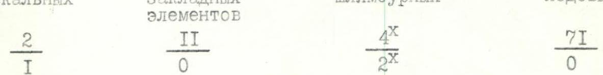 x — previously driven hooks were used
9. NUMBER OF CLIMBING HOURS – 20 hours, including descent
10. NUMBER OF NIGHTS SPENT – NONE
II. TEAM COMPOSITION: captain – Grigorov Andrey Vladimirovich
members:
x — previously driven hooks were used
9. NUMBER OF CLIMBING HOURS – 20 hours, including descent
10. NUMBER OF NIGHTS SPENT – NONE
II. TEAM COMPOSITION: captain – Grigorov Andrey Vladimirovich
members:
- Pestrikov Vladimir Valerievich
- Kovalenko Valery Vitalievich
- Kochetkov Ruslan Yurievich
- Shvets Pavel Anatolievich
- TEAM COACH: Serdyukov Ivan Ivanovich
- DEPARTURE FOR THE ROUTE FROM THE BIVOUAC... February 7, 1994 at 4:00. REACHING THE SUMMIT... February 7, 1994 at 15:30. RETURN TO THE BIVOUAC... February 7, 1994 at 24:00.
- Team of the Elbrus Training and Methodological Center
BRIEF OVERVIEW OF THE CLIMBING AREA
Ullu-Tau (4207 m), the most technically challenging massif in the Adyr-Su valley, with distinct Eastern, Main, and Western peaks, is located in the GKKh between the peaks of Sarykol beyond the Mestia pass to the east and the Cheget-Tau massif beyond the Garvash pass to the west. The route to the Main peak of Ullu-Tau via the North face, first ascended by V.M. Abalakov's team, is one of the most logical and challenging paths, leading directly to the Main peak. The route is characterized by alternating ice and rock sections, which in winter conditions further increases the objective difficulties of the ascent.
PREPARATION FOR THE ASCENT
Preparation for the Championship (of Russia, CIS, etc.) began in the fall with individual plans drawn up by the team's senior coach, I.I. Serdyukov. The team participated in the Ukrainian Championship in the "Small Mountains" (Shvets P.A. – III place). During the winter season, the team completed a series of ascents (peak Kurychi – 1B; peak Germagenova – 3B); acclimatization outings, ice training on the Kashkatash glacier, and rock training for rescuers. During the period preceding the ascent, the team's equipment and tactics were tested, and the personal experience of climbing in winter conditions was generalized and systematized.
On February 3, the team traveled to the Adyr-Su valley. On February 4, after receiving additional consultations from the deputy director for educational and sports work at the Ullu-Tau Alpine Sports Base (AUSB), Mr. Makarenko N.F., the team made an outing to the North face of Ullu-Tau to organize a base camp (cave) and scout the route. On February 5, due to deteriorating weather conditions (strong wind, lack of visibility), they descended to the Ullu-Tau AUSB. On February 6, they again approached the mountain and, after spending the night in a previously prepared cave, set out on the route on February 7 at 4:00.
TACTICAL ACTIONS OF THE TEAM
Departure at 4:00. They traversed the closed glacier in teams with electric torches and, with the onset of morning twilight, reached the bergschrund. Overcoming the bergschrund in winter does not present particular difficulties. The icy part of the route was traversed with simultaneous movement of teams (Kovalenko-Pestrikov, Shvets-Kochetkov-Grigorov). Both teams used ice screws screwed in by the lead climber. As necessary, ice screws from the last participant of the second team were passed to the lead climber using cordelettes attached to the leader of each team. At 10:00, having passed the "rhombus," they reached monolithic frozen rocks. They continued to move in crampons with ice axes, using, in addition to ice screws, belay devices and rock pitons for protection. At times, only the leader of the first team changed, with both simultaneous and alternating movement. At 12:30, they approached the key section of the route – the chimney. Using fixed ropes and pitons left by previous groups, they traversed the chimney with the organization of fixed ropes. At 14:00, they reached the ice ridge – the "knife." From there to the summit, they worked in the tactical order described above, interacting via the ice screws left by the first team. At 15:30, they reached the Main peak of Ullu-Tau and began their descent, initially following the ascent route, and then, from the ice "knife," they descended east of the ascent route towards the Chernoslivin route, bypassing the rocks of the North face on ice. Until 18:00, they descended in independent teams, removing ice screws. Later, with the onset of darkness, the last 250-300 m of the wall were descended by the entire group, using both ice screws and slings on outcrops. In the darkness, the descent pace slowed, but:
- by 23:00, the group had overcome the bergschrund
- by 24:00, they had descended to the snow cave where the bivouac was organized. During the ascent, the group maintained radio contact with the KSP in the Adyr-Su valley via the "Lastochka" radio station, and were also constantly visually monitored by the operational duty officer of the Elbrus PSS, N.P. Kiselev, and the deputy director for educational work at the Ullu-Tau AUSB, N.F. Makarenko, from the Ullu-Tau AUSB. The successful execution of the tactical plan was facilitated by:
- a rational set of equipment and emergency bivouac gear
- traversing the majority of the route simultaneously with team interaction via pitons
- high individual preparation for movement on ice and frozen rocks for all team members.
There were no significant deviations from the planned time and route, nor any failures or injuries within the team. The tactical plan was fully executed.
DESCRIPTION OF THE ROUTE BY SECTIONS
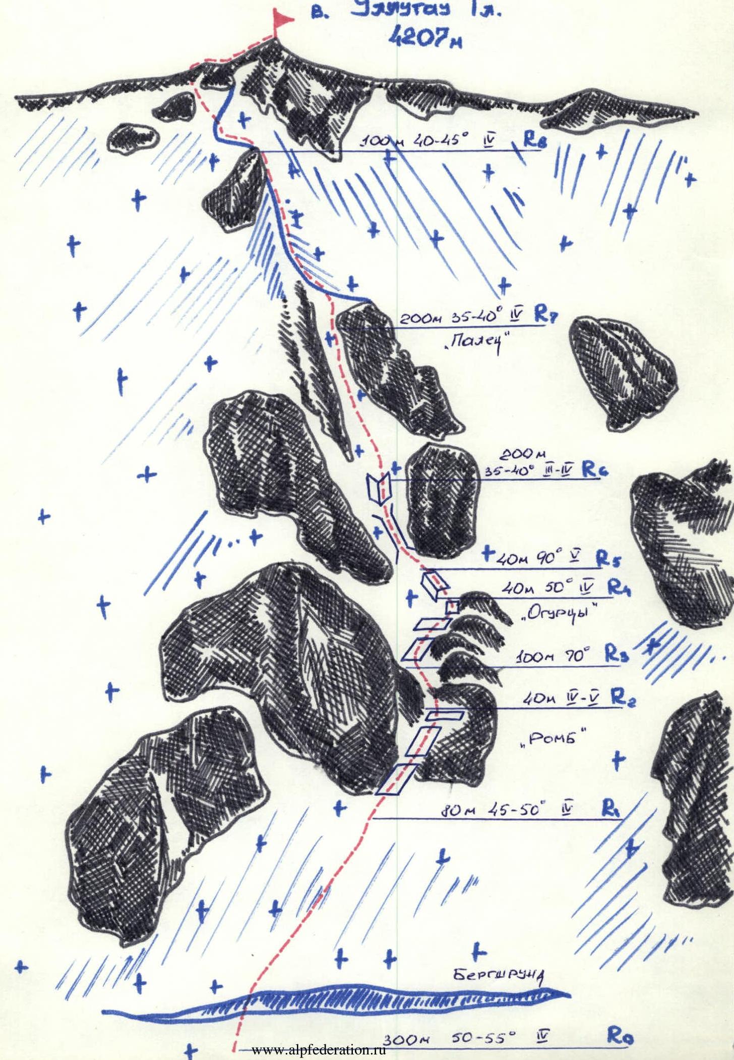
From the bivouac on the moraine deposits under the North face (so-called "Central rocks") – up the relatively gentle closed glacier to the bend of the marginal crevasse. R0 – we cross the bergschrund via a snow bridge. Ascent up the ice slope with a steepness of 50-55° (very hard ice) over a distance of 300 m in the direction of the rock outcrop "rhombus." R1 – to the top of the "rhombus," initially via a broad couloir located in the left part of the "rhombus" (60-65°, ice), then via a crack (frozen rocks). Protection via ice screws. R2 – from the "rhombus" to the base of the tower via an ice slope with outcrops of snow-covered rocks and stones. R3 – from the tower – traverse right to a shoulder composed of three steps of monolithic frozen rocks. R4 – from the third step of the shoulder, up and left along the destroyed ridge to a platform under the chimney (protection on the section via ice screws, rock pitons, and belay devices). R5 – from the platform, up the chimney, very difficult climbing (fixed ropes, pitons). R6 – further via a system of rock blocks (frozen, snow-covered rocks alternating with ice outcrops, 60°) to the ice ridge. R7 – along the ridge up to the summit tower, 45°, very hard ice. R8 – bypassing the summit tower on the left via ice with rock outcrops, ascent to the Main peak of Ullu-Tau via a relatively narrow ice couloir.
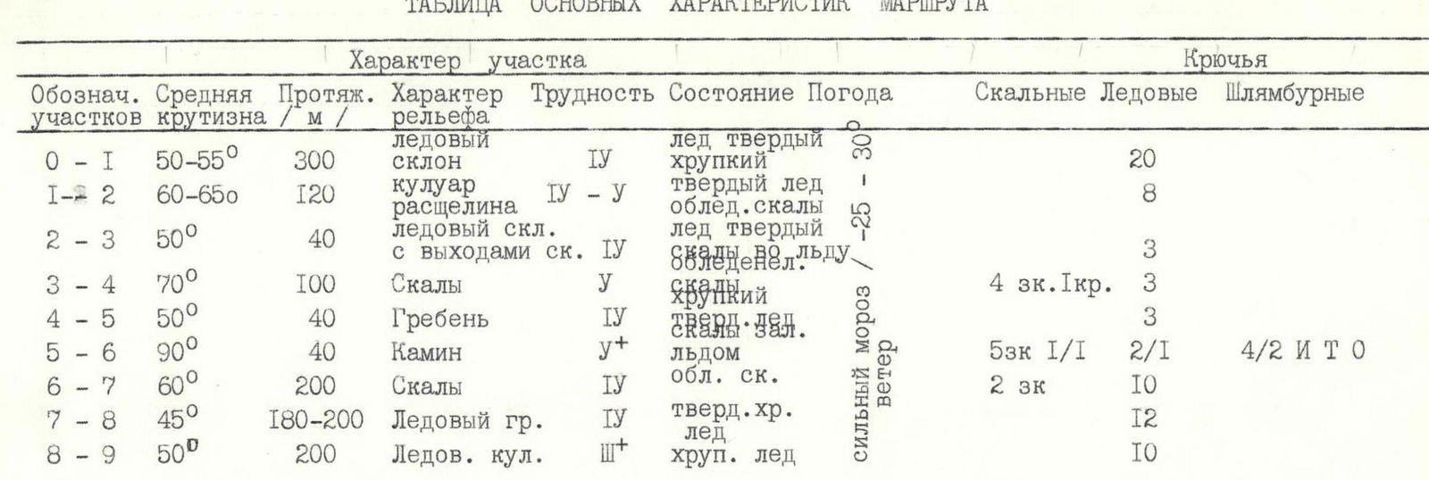
TABLE OF MAIN ROUTE CHARACTERISTICS
The group reached the summit at 15:30, descending east of Abalakov's route via the Chernoslivin route. Departure on February 7, 1994, at 4:00. Descent to the cave by 24:00. Total climbing hours: 20, of which:
- ascent – 11 hours 30 minutes,
- descent – 8 hours 30 minutes.