REPORT
on the ascent to the peak Vostochnaya Ullu-tau-chana via the northern bastions of the shoulder, category 5B difficulty
Moscow 1972
2. History of the Massif Exploration
Exploration of the Ullu-tau-chana massif began in 1933 when A. Japaridze and G. Nigurianti ascended to the Main Peak from the Lekzyr glacier from the Mestia pass via a route of category 3B difficulty, and to the Western Peak from the Garvash pass via a route of category 2B difficulty. Before the war, both complete traverses of the massif of category 4B difficulty were also first accomplished:
- 1937 — L. Nadezhdin and V. Nazarov — from west to east;
- 1938 — A. Zolotarev, F. Kropf, V. Mauer, and V. Nesterov — from east to west;
and in 1946 — the first ascent via the "board" to the Western Peak with a subsequent traverse of the massif to the east, category 5A difficulty — D. Gudkov, M. Zvezdkin, M. Chertkov, G. Odnoblyudov.
In the 1950s, the assault on the northern walls began:
- 1951 — V. Abalakov, M. Anufrikov, A. Borovikov, N. Gusak, V. Kizel, V. Nagaev, L. Filimonov, V. Cheredova — Main Peak "Central" via the northern wall, category 5B difficulty;
- 1954 — E. Monucharov, E. Emelyanov, G. Kalepov, B. Sadovsky, G. Senachev, Yu. Chernoslivin — Eastern Peak via the northern wall, category 5B difficulty;
- 1956 — E. Emelyanov, N. Vinukov, P. Dyakonov, A. Kikoin, D. Kuzminykh, V. Kindyakov, A. Rafaelyan, V. Shakhov, A. Smorkalov, L. Sereskelidi — Eastern Peak from the hut via the NE counterfort, category 4B difficulty;
- 1959 — Yu. Chernoslivin, V. Ruzhevsky, G. Senachev, A. Chernyshov — Eastern Peak via the ice slope and bastion of the shoulder, category 5B difficulty.
Two first ascents were made in the 1960s:
- 1965, March — Yu. Chernoslivin, N. Margiani, Yu. Porokhnya, V. Ruzhevsky, E. Sokolovsky, M. Khergiani — ice slope with rocky outcrops between the Main and Eastern Peaks — category 5B difficulty.
- 1966, July — A. Naumov, Yu. Moiseev, M. Druy, Yu. Kozlov — Eastern Peak via the Northern bastions of the shoulder — category 5B difficulty.
And finally, in 1971, a group consisting of V. Maltsev, A. Bakulin, E. Zubov, Yu. Solovyov, M. Ovchinnikov, G. Yakovlev ascended via the ice slope with rocky islands between the Main and Western Peaks — category 5B difficulty.
3. Brief Characteristics of the Route
This report is dedicated to the ascent to the Eastern Peak of Ullu-tau-chana via the northern bastions of the shoulder, category 5B difficulty, in July 1972. The first ascenders, led by A. Naumov, were the only group to have been on this route before us, and they were awarded 4th place in the 1966 USSR Championship.
The almost purely rocky, kilometer-long route has an average steepness of 62° and contains about 400 meters of extremely difficult sections.
To the right and left of the route, there are paths of strong rockfalls that make detours impossible but do not affect the route.
The rocks of the upper bastions are monolithic, highly smoothed. The lower part of the wall is partially destroyed, and on the monolithic upper part, there are loose rocks.
4. Route Reconnaissance
During the preparation for the 1972 season, the group thoroughly studied the report of the first ascender, A. Naumov, and planned reconnaissance during the approach and ascent to the peak Sarykol-bashi, category 3B difficulty. However, bad weather and tight deadlines due to being busy with instructor work at the "Dzhailyk" alpine camp made adjustments. As a result, the reconnaissance consisted of:
- observing the route from the left bank of the Adyr-su River opposite the camp through a 40x telescope, from Mestia overnight stays, and from the Mestia hut through 3x binoculars;
- observing and sketching the route from overnight stays under it, where the group made a supply of equipment and food on July 4-5.
All this allowed for a thorough examination of the entire route, especially its lower part, identifying a section to cross the bergschrund, and developing a tactical ascent plan that was fully executed.
5. Group Composition
The group set out for the ascent in the following composition:
- Master of Sports Khackevich I.G. — leader;
- Candidate for Master of Sports Nikulin M.G.;
- Candidate for Master of Sports Sobolev S.S.;
- Candidate for Master of Sports Kuznetsov A.B.;
- Volkov V.I. — 1st sports category;
- Ryabov Yu.I. — 1st sports category.
All participants in the ascent are instructors at the "Dzhailyk" alpine camp, having worked there for many years, knowing each other for a long time, and having experience in joint ascents.
In the 1972 season, they all worked a shift at the camp, were well acclimatized, physically and technically well-prepared, and had a joint ascent to the peak Cheget-tau-chana, category 3A difficulty.
6. Ascent Diary
The group left the camp on July 15 at 10:00. Passing Mestia overnight stays, they crossed to the left (orographic) bank of the Adyr-su River along the edge of the Adyr-su glacier tongue. They ascended the moraine ridge, bypassed the glacier tongue, and climbed a snowy couloir with a rocky belt in the upper part to the snowy plateau of the cirque. To the right before the cirque, on scree, there were rocky outcrops — a bivouac site. From the camp — 4 hours.
On July 16 at 4:00, the first pair set out on the route, and 20 minutes later, the rest followed after packing the tent. The whole day had good weather, but due to clouds and the northern exposure of the slope, it was cool.
The path initially went along a closed glacier, then:
- ascended a snowy slope;
- crossed the bergschrund via a "cork";
- ascended ice with pitons under the rocks.
They traversed 10 meters to the most convenient exit to the rocks and ascended them. The steepness and difficulty continually increased. Vertical ascent alternated with inclined sections, sometimes simple ledges leading to the right and eventually to a couloir with falling rocks. It was not possible to go further to the right.
From here, a very difficult path:
- directly up the wall;
- bypassing a characteristic "tooth" on the left;
- again up a practically sheer, dirty wall with few handholds.
80 meters of very difficult work, and the rocks become somewhat gentler. The 1st bastion was passed, but there were no places for a tent, only individual ledges for 1-2 people (point 9).
After searching for a path and consultations, they decided to ascend to the 2nd bastion without backpacks. First, they went left-up to the ridge, then exited with a slight descent to steep ice under practically overhanging rocks and made a long ascent left-up along the rocks, cutting steps. Pitons were driven alternately:
- into ice;
- into rocks.
Then a sheer, sometimes very difficult couloir with many loose rocks led to the top of the 2nd bastion (point 14).
A platform for a tent on an almost horizontal snowy ridge was made in 2 hours; one person cut steps first, then two. The others were busy:
- pulling backpacks up the sheer 80-meter wall;
- re-crossing the path;
- pulling the last participant up by rope directly from point 9.
By 20:00, everyone was at the overnight stay.
On July 17 at 8:00, they began the ascent to the 3rd bastion. The smoothed rocks were initially very difficult, then became somewhat gentler and turned into a fairly simple ridge abutting a wall of the 4th bastion. To the right, there was a snowy-ice slope with a small steep ridge.
The weather, which was decent in the morning, completely deteriorated by the end of the day. Simultaneously with processing the wall, they began to cut the ridge. Since, after cutting through the snow and reaching the rocks, they still hadn't achieved the necessary width for a platform, they had to build it up from below with large snow blocks, about 0.5 meters in size.
Three of them made the platform in 3 hours; they set up the tent when it was already snowing. They hung 50 meters of rope to the 4th bastion. By 14:00, everyone was in the tent; it was snowing heavily.
On July 18, the weather gradually cleared up from morning. From 6:00, they began to ascend via the hung ropes on abaals and further processed the wall.
The approach to the wall was via destroyed rocks to the left of a huge rock standing before it; they ascended it via an internal corner and then along the wall with a crack going left-up, for 40 meters. Since the rope went zigzag, they had to extend the first 40-meter rope.
Further, they had to move to the right:
- along a smooth slab (3 pitons);
- along a snowy-ice slope.
Via a chimney filled with ice, they exited to a counterfort and along it to the ridge of the 4th bastion (point 24). The route turned to the right, but to pull up the backpacks, four had to go left, first along the ridge, then to the right of it along a ledge. To it, almost from the overnight stay, they pulled the backpacks 100 meters, and two participants ascended.
The path along the ridge was not difficult, with detours to the right. Then they crossed a couloir and ascended not very difficult but highly destroyed rocks to a steep snowy ridge — the overnight stay site. Again, they spent about 3 hours cutting and arranging the platform.
The next day, it turned out that from this place to a wide, even saddle under the "ogurtsy" was only an hour to an hour and a half walk. The tent was set up by 20:00.
On July 19, the weather was excellent, but in the morning, at a high altitude among the snows, it was very cold. The group set out around 8:00; via not very difficult, highly destroyed rocks, they exited left-up to a saddle in the Ullu-tau ridge, ascended to the peak without backpacks via a route of category 3B difficulty.
Returning to their backpacks, they began the descent from the saddle to the south via a snowy couloir (in August, it's icy). Not reaching the end of the couloir, they exited left to scree and descended to the glacier along it.
The path to the Mestia pass goes with a slight ascent.
By 19:00, the group was back at the "Dzhailyk" camp.
8. Overall Assessment of the Participants' Actions
The participants in the ascent — instructors at the "Dzhailyk" alpine camp, having worked there for many years, knowing each other for a long time, and having experience in joint ascents both in previous seasons and in 1972.
All participants actively worked both during the preparatory period and during the entire ascent. On the route, the group acted clearly and coherently. Practically everyone got to work at the front, which they constantly strived for. All participants demonstrated good physical, technical, and moral preparation and successfully coped with the route.
TABLE
MAIN CHARACTERISTICS OF THE ASCENT ROUTE
Ascent Route: Vostochnaya Ullu-tau-chana via the northern bastions of the shoulder Route Elevation Gain: 950 m Including the most difficult sections: 400 m Steepness: 62°
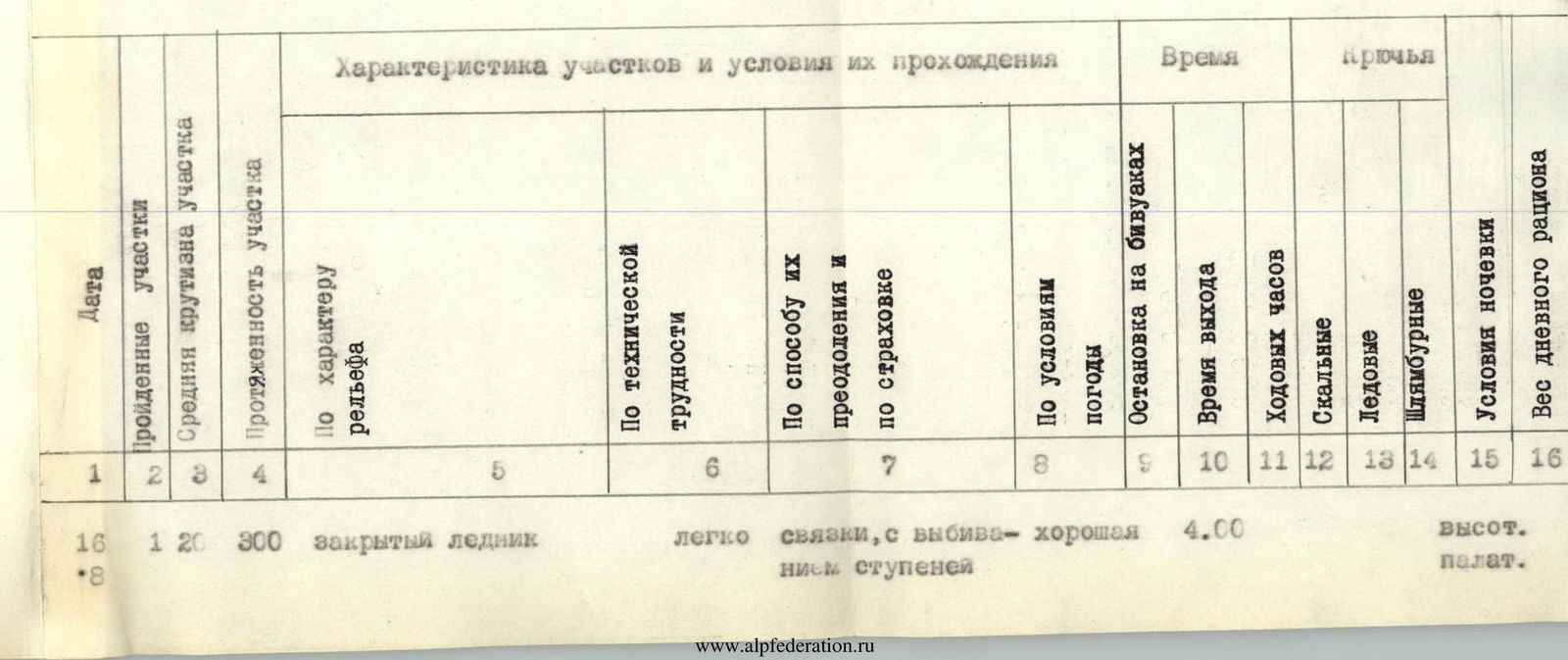
| № | Date | Length, m | Steepness, ° | Relief Characteristics | Technical Difficulty | Method of Overcoming and Belay | Weather | Conditions at Bivouacs | Time of Exit | Working Hours | Rock Pitons, pcs | Ice Pitons, pcs | Bolts, pcs | Camping Conditions | Daily Ration Weight, kg |
|---|---|---|---|---|---|---|---|---|---|---|---|---|---|---|---|
| R0 | 16 | 300 | 20 | closed glacier | easy | rope teams, with step cutting | good | 4:00 | high-altitude tent | ||||||
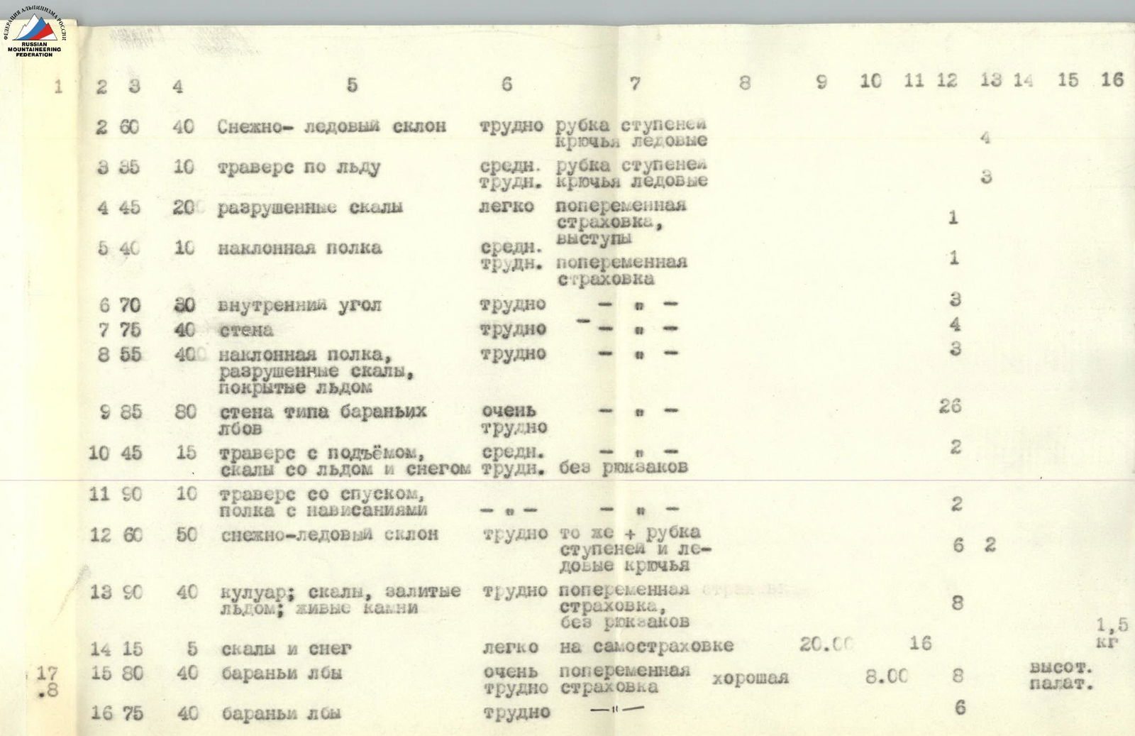
| R1 | 60 | 40 | snowy-ice slope | hard | step cutting, ice pitons | 4 | |||||||||
| R2 | 35 | 10 | ice traverse | medium difficulty | step cutting, ice pitons | 3 | |||||||||
| R3 | 45 | 200 | destroyed rocks | easy | alternate belay | 1 | |||||||||
| R4 | 40 | 10 | inclined ledge | medium difficulty | ledges, alternate belay | 1 | |||||||||
| R5 | 70 | 30 | internal corner | hard | — | 3 | |||||||||
| R6 | 75 | 40 | wall | hard | — | 4 | |||||||||
| R7 | 55 | 400 | inclined ledge, destroyed rocks covered with ice | hard | — | 3 | |||||||||
| R8 | 85 | 80 | wall like "baran'ii lby" | very hard | — | 26 | |||||||||
| R9 | 45 | 15 | traverse with ascent, rocks with ice and snow | medium difficulty | without backpacks | 2 | |||||||||
| R10 | 90 | 10 | traverse with descent, ledge with overhangs | — | 2 | ||||||||||
| R11 | 60 | 50 | snowy-ice slope | hard | the same + step cutting and ice pitons | 6 | 2 | ||||||||
| R12 | 90 | 40 | couloir; rocks filled with ice; loose rocks | hard | alternate belay, without backpacks | 8 | |||||||||
| R13 | 17 | 15 | 5 | rocks and snow | easy | on self-belay | 20:00 | 1,5 | |||||||
| R14 | 80 | 40 | "baran'ii lby" | very hard | alternate belay | good | high-altitude tent | 8:00 | 8 | ||||||
| R15 | 75 | 40 | "baran'ii lby" | hard | — | 6 | |||||||||
| R16 | 45 | 40 | ridge | medium difficulty | alternate belay | deterioration | 14:00 | 6 | 3 | 1,2 | |||||
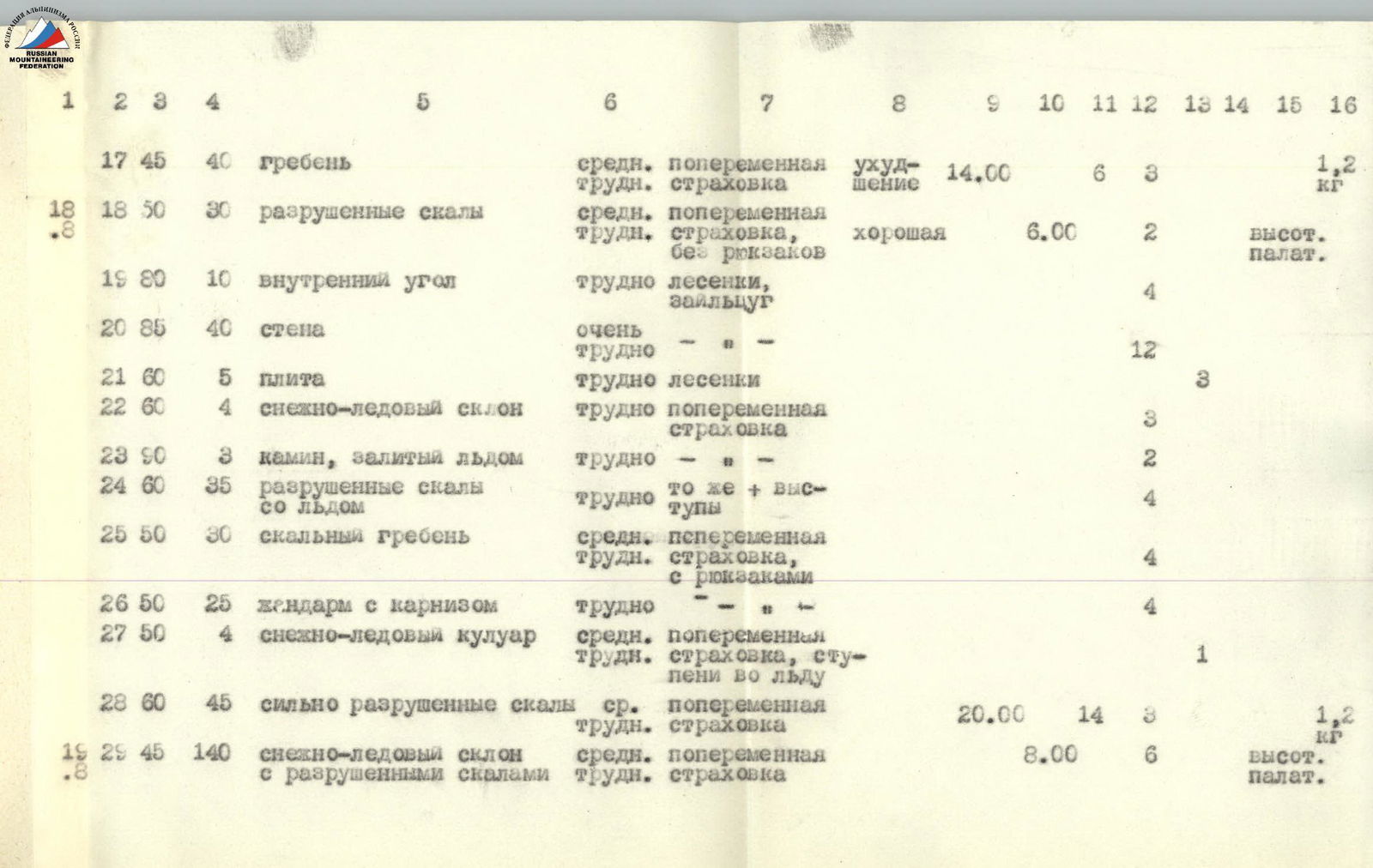
| R17 | 18 | 50 | 30 | destroyed rocks | medium difficulty | alternate belay, without backpacks | good | high-altitude tent | 6:00 | 2 | |||||
| R18 | 80 | 10 | internal corner | hard | ladders, zaiceug | 4 | |||||||||
| R19 | 85 | 40 | wall | very hard | — | 12 | |||||||||
| R20 | 60 | 5 | slab | hard | ladders | 3 | |||||||||
| R21 | 60 | 4 | snowy-ice slope | hard | alternate belay | 3 | |||||||||
| R22 | 90 | 3 | chimney filled with ice | hard | — | 2 | |||||||||
| R23 | 60 | 35 | destroyed rocks with ice | hard | the same + ledges | 4 | |||||||||
| R24 | 50 | 30 | rocky ridge | medium difficulty | alternate belay, with backpacks | 4 | |||||||||
| R25 | 50 | 25 | sentinel with a cornice | hard | — | 4 | |||||||||
| R26 | 50 | 4 | snowy-ice couloir | medium difficulty | alternate belay, steps in ice | 1 | |||||||||
| R27 | 18 | 60 | 45 | highly destroyed rocks | medium difficulty | alternate belay | high-altitude tent | 20:00 | 14 | 3 | 1,2 | ||||
| R28 | 19 | 140 | 45 | snowy-ice slope with destroyed rocks | medium difficulty | alternate belay | high-altitude tent | 8:00 | 6 | ||||||
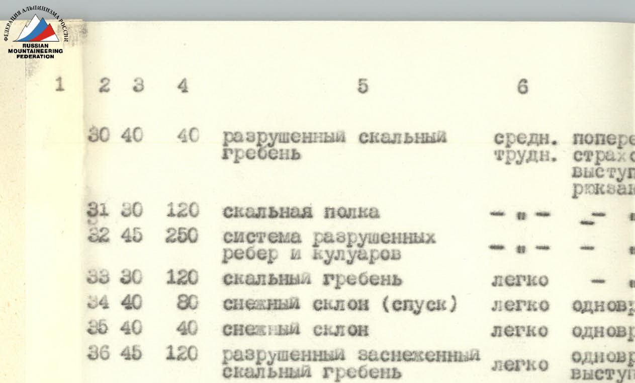
| R29 | 40 | 40 | destroyed rocky ridge | medium difficulty | alternate belay, ledges; without backpacks | 3 | |||||||||
| R30 | 30 | 120 | rocky ledge | — | 3 | ||||||||||
| R31 | 45 | 250 | system of destroyed ribs and couloirs | — | 12 | ||||||||||
| R32 | 30 | 120 | rocky ridge | easy | — | ||||||||||
| R33 | 40 | 80 | snowy slope (descent) | easy | simultaneously | ||||||||||
| R34 | 40 | 40 | snowy slope | easy | simultaneously | ||||||||||
| R35 | 45 | 120 | destroyed snowy rocky ridge | easy | simultaneously, ledges | 11 | 1 |
Note to pos. 7: Everywhere, unless specifically stated otherwise, the route was overcome by free climbing with piton belay.