PASSPORT
- Technical class
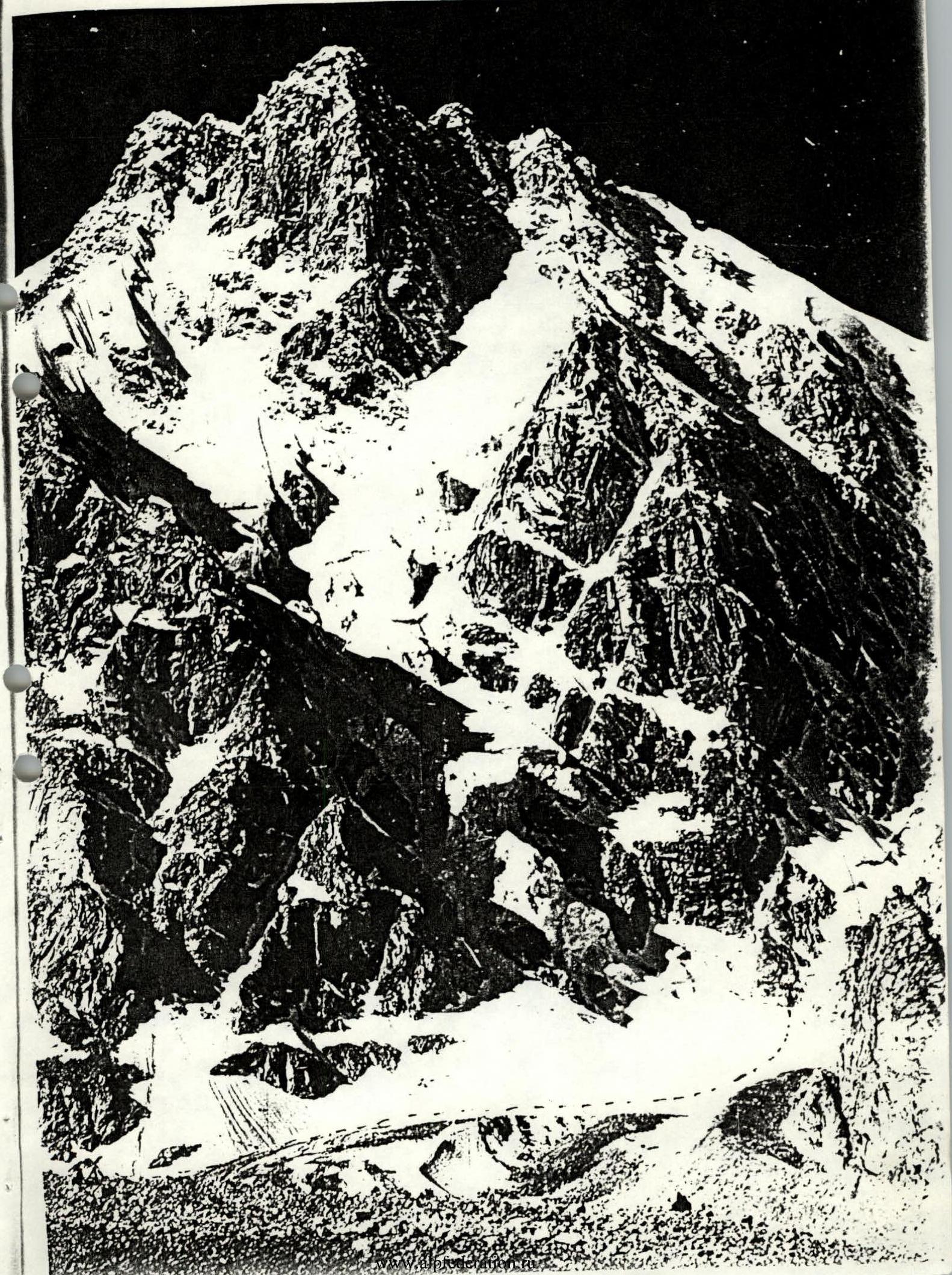
- Central Caucasus, Tyutyu-Su gorge
- V. Tyutyu, 2nd Zap. via N. side, 4420 m
- 6A category of difficulty
- Height difference: 1400 m, length 2100 m
Length of sections with 6A–6B category of difficulty is 380 m. Average steepness of the main part of the route is 65° (3050–4150 m)
- Number of pitons hammered:
rock bolt pitons ice screws 20 96 26
- 17 walking hours and 1 day
- Overnight stays: on the summit of 2nd Zap.
- Leader — Antonov Sergey Ivanovich CMS
Participants:
- Krainov Petr Nikolaevich CMS
- Kirichek Pavel Nikolaevich CMS
- Lisetsky Andrey Vladimirovich 1st sports category
- Coach — Tislyatsky Albert Ivanovich MS, instructor II category
- Departure to the route: July 27, 1994
Reached the summit: July 27, 1994 Returned: July 28, 1994
- Organization: ALP "Strannik"
Tactical actions of the team
The departure to the route was delayed by one day due to bad weather: thunderstorm, zero visibility, rain with snow.
We started the route on July 27, 1994, at 4:00 (delayed by 2 hours due to thick fog). The weather was unstable, we decided not to relax and go, while visibility and weather permitted. The rope teams were organized as follows:
- Antonov S. — Krainov P.
- Kirichek P. — Lisetsky A.
The rope teams were equal, on sections II–IV category of difficulty, movement was independent along the left pitons, on sections V–VI category of difficulty, movement was along the fixed ropes. The lead climbers constantly changed, so the route was passed relatively quickly, without neglecting safety.
On the route, we used chocks, rock and ice pitons. There were no falls or injuries. The team acted in a coordinated manner throughout the entire ascent. Food, equipment, and margin of safety were sufficient to continue the ascent in conditions of severe bad weather.
3. Tyutyu with the ascent route indicated
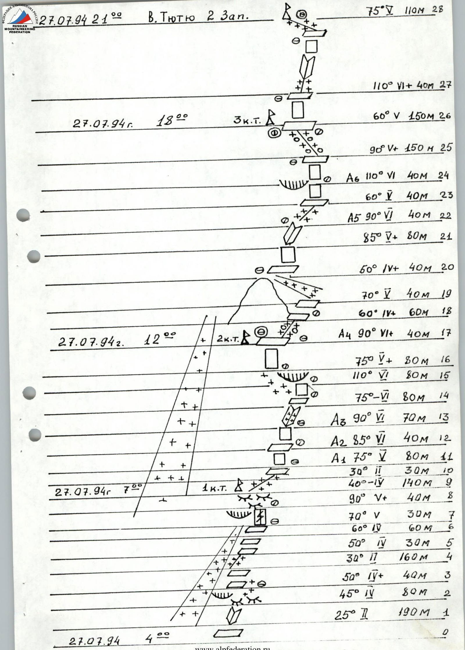
July 27, 1994, 21:00 V. Tyutyu 2 Zap. R28: 75°, 110 m R27: 110° VI+, 40 m July 27, 1994, 18:00 3rd CT R26: 60° V, 150 m R25: 90° V+, 150 m R24: А6, 110° VI, 40 m R23: 60° V, 40 m R22: А5, 90° VI, 40 m R21: 85° V+, 80 m R20: 50° IV+, 40 m R19: 70° V, 40 m R18: 60° II+, 60 m R17: А4, 90° VI+, 40 m 2nd CT R16: 75° V+, 80 m R15: 110° VI, 80 m R14: 75°–VI, 80 m R13: А3, 90° VI, 70 m R12: А2, 85° VI, 40 m R11: А1, 75° V, 80 m July 27, 1994, 7:00 1st CT R10: 30° II, 30 m R9: 40°–IV, 140 m R8: 90° V+, 40 m R7: 70° V, 30 m R6: 60° IV, 60 m R5: 50° IV, 30 m R4: 30° II, 160 m R3: 50° IV+, 40 m R2: 45° IV, 80 m R1: 25° II, 190 m July 27, 1994, 4:00 R0
Brief description of the route
Section R0–R1 — crossing the bergschrund to a slanting ledge.
Section R1–R2 — an inner corner onto a sloping shelf with loose rocks on smoothed "ram's foreheads" under an overhanging rock.
Section R2–R3 — detour to the right along the boundary between snow and rock.
Section R3–R4 — ascent left-up to a ledge along a snow-ice slope to a couloir.
Section R4–R5 — along the right part of the couloir to a snowy saddle and along it to a slanting ledge.
Section R5–R6 — up-right along the wall to an overhanging wall.
Section R6–R7 — along an inclined slab up-left to an overhanging wall.
Section R7–R8 — up along a crack to a slanting ledge.
Section R8–R9 — along "ram's foreheads" and slanting ledges to a snowy shoulder (1st control point).
Section R9–R11 — from the shoulder up along a snowy ridge, along an ice slope to a large inner corner.
Section R11–R12 — along the right part of the inner corner up-left (ladder), then up-right to a ledge.
Section R12–R13 — along large blocky rocks straight up to an icy inner corner (ladder).
Section R13–R14 — up along the corner to a ledge.
Section R14–R15 — along smooth slabs under overhanging rocks, which are bypassed on the left along an ice slope.
Section R15–R17 — up along the wall to a platform (ladder) (2nd control point).
Section R17–R18 — from the platform straight up under a tower.
Section R18–R19 — the tower is bypassed on the right along a narrow ledge, exit to a couloir.
Section R19–R20 — along the boundary between ice and rock of the couloir, ascent to a tower.
Section R20–R22 — along large blocky rocks straight up to a ledge, then along a steep inner corner, ascent to a ridge (ladder).
Section R22–R23 — further along a steep ridge up under an overhanging wall.
Section R23–R24 — the cornice is bypassed on the right along slabs (ladder).
Section R24–R26 — further straight up along slabs and walls to an ice-snow ridge, along the ridge to a platform (3rd control point).
Section R26–R27 — from the platform left-up along an overhanging wall (ladder) to a ledge.
Section R27–R28 — along the ledge up-right and along an inner corner under a rocky ascent to the summit. Along broken rocks and an ice-snow shoulder to v. Tyutyu 2nd Western.