North Caucasus and Southern Federal Districts Climbing Championship
high-altitude technical class
REPORT
On the ascent of Jailyk peak via the 3rd wall of the S. shoulder of the S. ridge (D. Laskavy's route) 5B category of complexity by the team from Rostov Region for the period from July 24–25, 2024.
I. ASCENT DOCUMENTATION
| 1. General Information | ||
|---|---|---|
| 1.1 | Full Name, sports rank of the leader | Vasilyev Andrey Sergeevich, Master of Sports |
| 1.2 | Full Name, sports rank of participants | Vasilyeva Irina Vitalyevna, Candidate Master of Sports |
| 1.3 | Full Name of coach | Vasilyev Andrey Sergeevich, Master of Sports |
| 1.4 | Organization | Federation of Alpinism and Rock Climbing of Rostov Region, alpcamp "Planeta" |
| 2. Characteristics of the ascent object | ||
| 2.1 | Region | CAUCASUS, Central Caucasus |
| 2.2 | Valley | Adyr-Su |
| 2.3 | Number of the section according to the classification table of 2013 | 2.4.1 |
| 2.4 | Name and height of the peak | Jailyk, 4424 m |
| 3. Characteristics of the route | ||
| 3.1 | Name of the route | via the 3rd wall of the S. shoulder of the S. ridge (Laskavy's route) |
| 3.2 | Category of complexity | 5B |
| 3.3 | Degree of route exploration | - |
| 3.4 | Nature of the route terrain | Rocky |
| 3.5 | Height difference of the route | 450 m |
| 3.6 | Length of the route | 830 m |
| 3.7 | Technical elements of the route (total length of sections of various complexity categories with indication of terrain type (ice-snow, rocky)) | II cat. compl. (rocky) – 310 m. III cat. compl. (rocky, combined) – 335 m. IV cat. compl. (rocky) – 90 m. V cat. compl. (rocky) – 45 m. VI cat. compl. (rocky) – 50 m. Used ITO (A₁): 35 points (45 m) |
| 3.8 | Average steepness of the route, (°) | 55° |
| 3.9 | Average steepness of the main part of the route, (°) | 80° |
| 3.10 | Descent from the peak | Along the S. ridge, via Ruzhevsky's route 5A (“monk”) |
| 4. Characteristics of the team's actions | ||
| 4.1 | Time of movement (team's walking hours, indicated in hours and days) | 10 hours |
| 4.2 | Overnight stays | On a ledge near the “monk” gendarme |
| 4.3 | Time of route processing | - |
| 4.4 | Exit to the route | 6:40 July 24, 2024 |
| 4.5 | Exit to the peak | 13:07 July 25, 2024 |
| 4.6 | Return to the base camp | 12:00 July 26, 2024 |
| 5. Responsible for the report | ||
| 5.1 | Full Name, e-mail | Vasilyeva Irina Vitalyevna, rishi_polo@list.ru |
II. ASCENT DESCRIPTION
1. Characteristics of the Ascent Object
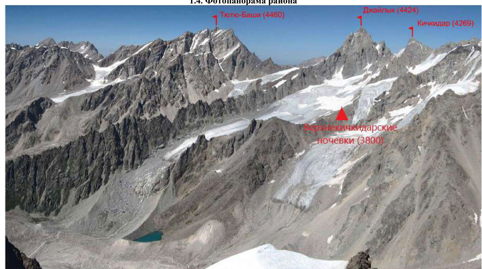
1.1. General photo of the peak

- along the S ridge (“monk”) (V. Ruzhevsky, 1967), 5A
- via the 3rd wall of the S shoulder of the S ridge (D. Laskavy, 1978), 5B
- via the left part of the 3rd wall of the S shoulder of the S ridge (V. Li), 5B
- via the 2nd S bastion of the 3rd rib (I. Khatskevich), 5B
- via the 1st S bastion of the 3rd rib (M. Frantsuzov, 1970) 5B
- via the 3rd rib (“lady's”) (V. Ruzhevsky, 1964) 5A
1.4. Photopanorama of the area
2. Characteristics of the Route
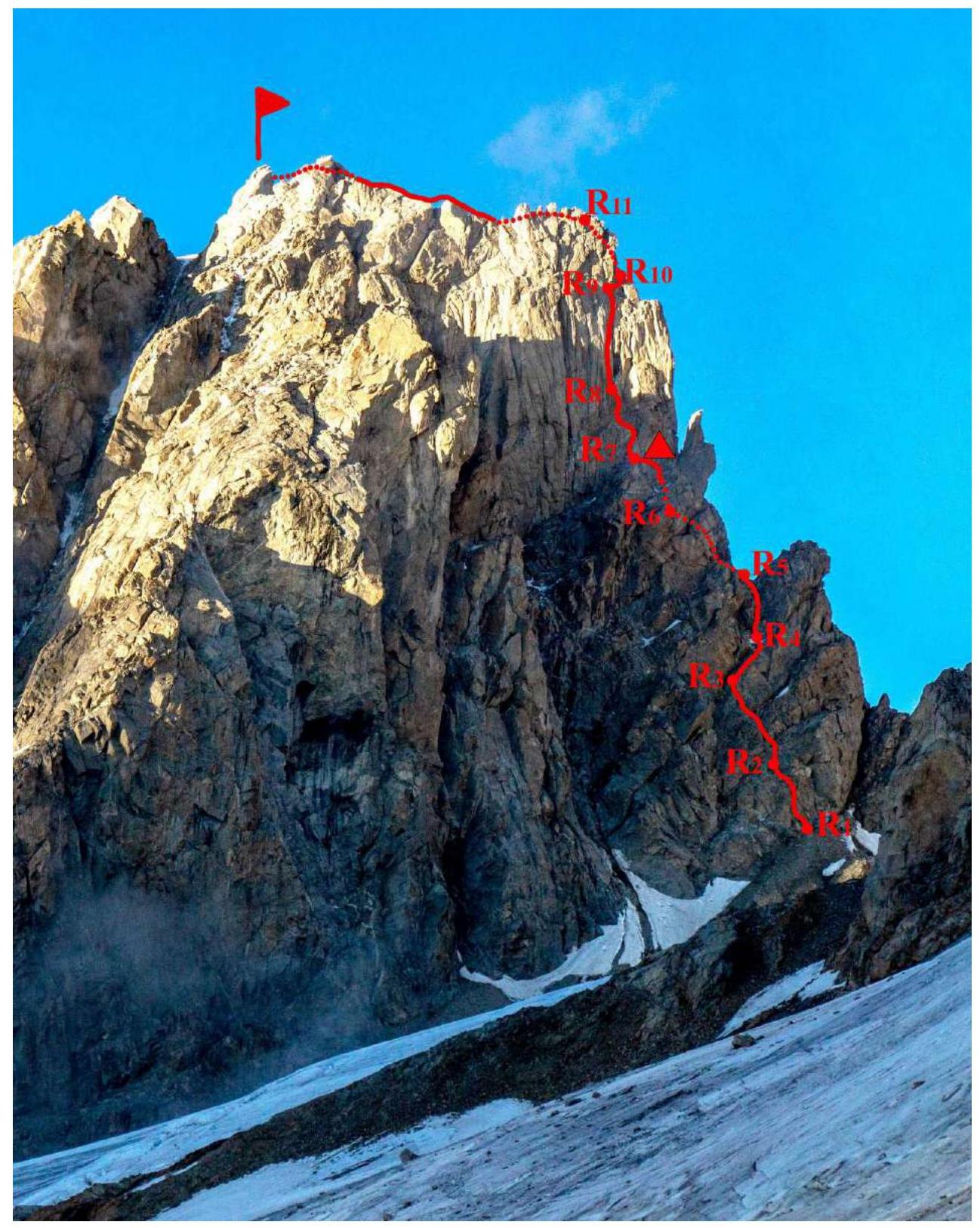
2.1. Technical photograph of the route
2.3. Route diagram in UIAA symbols
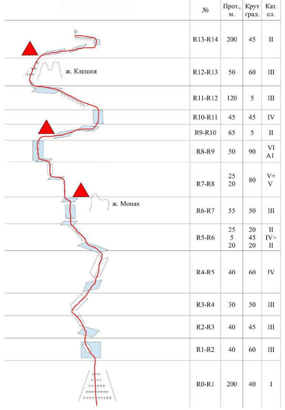
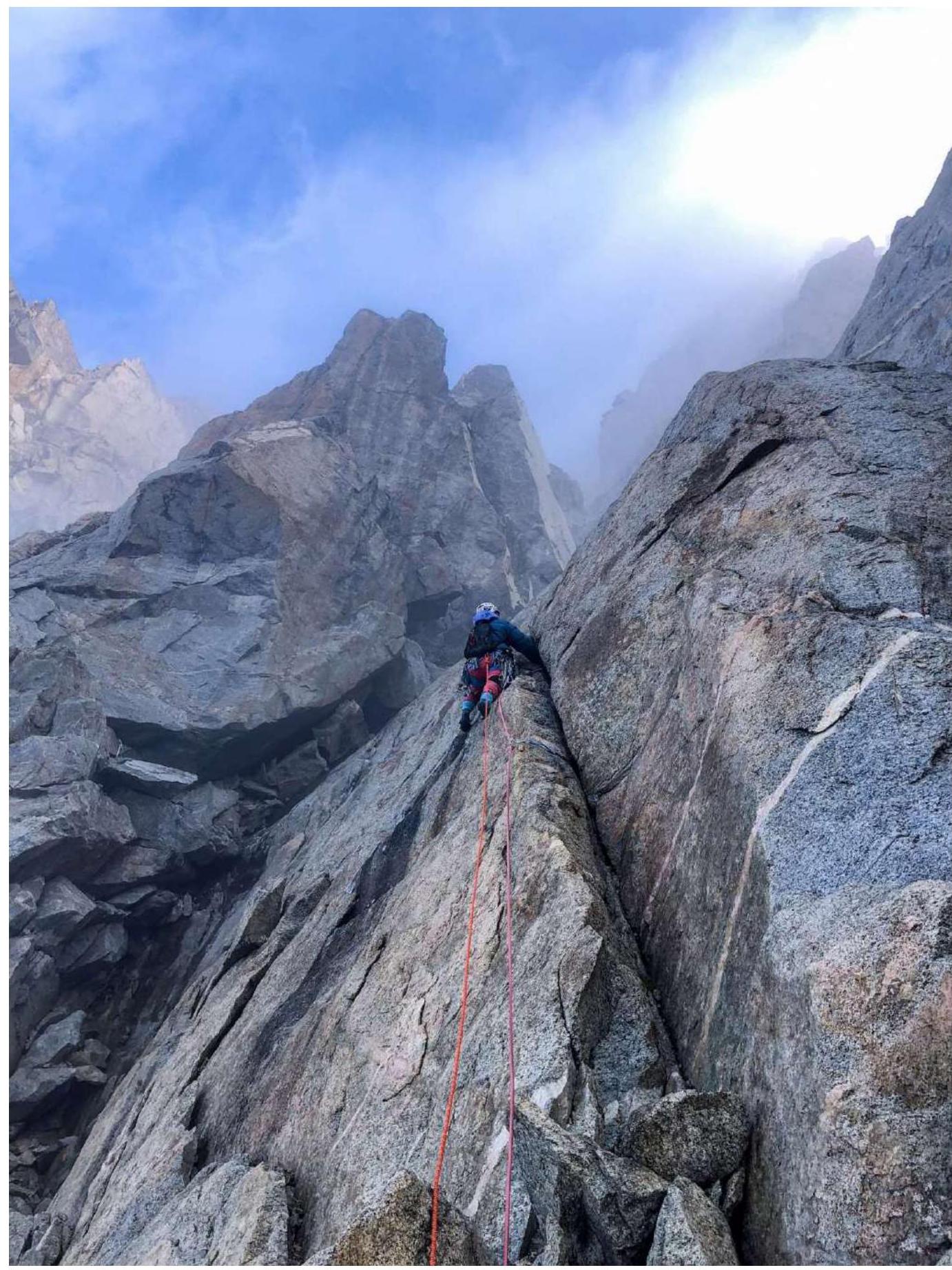
Photo 1. Section R1–R2. Start of the route.
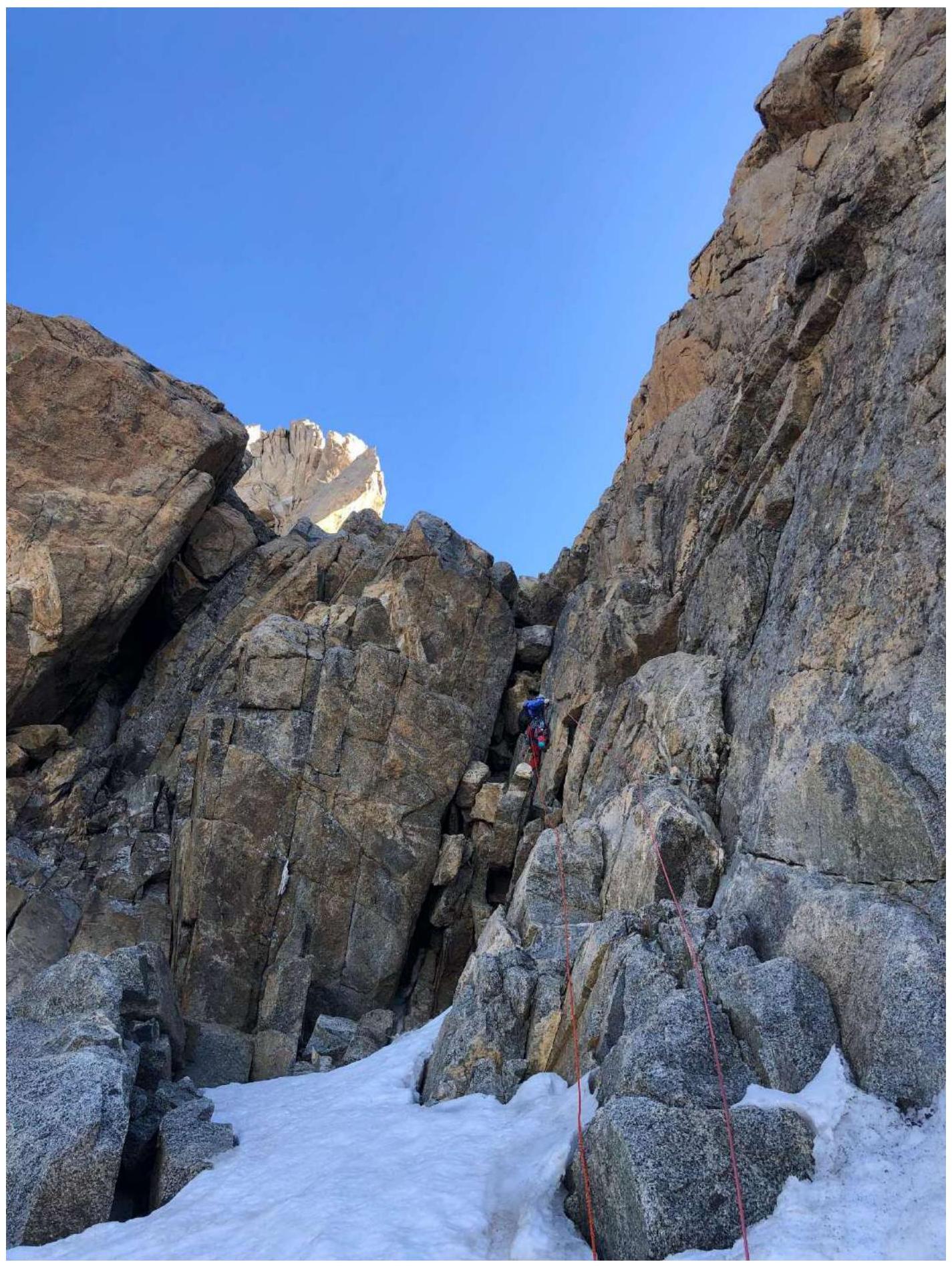
Photo 2. R4–R5
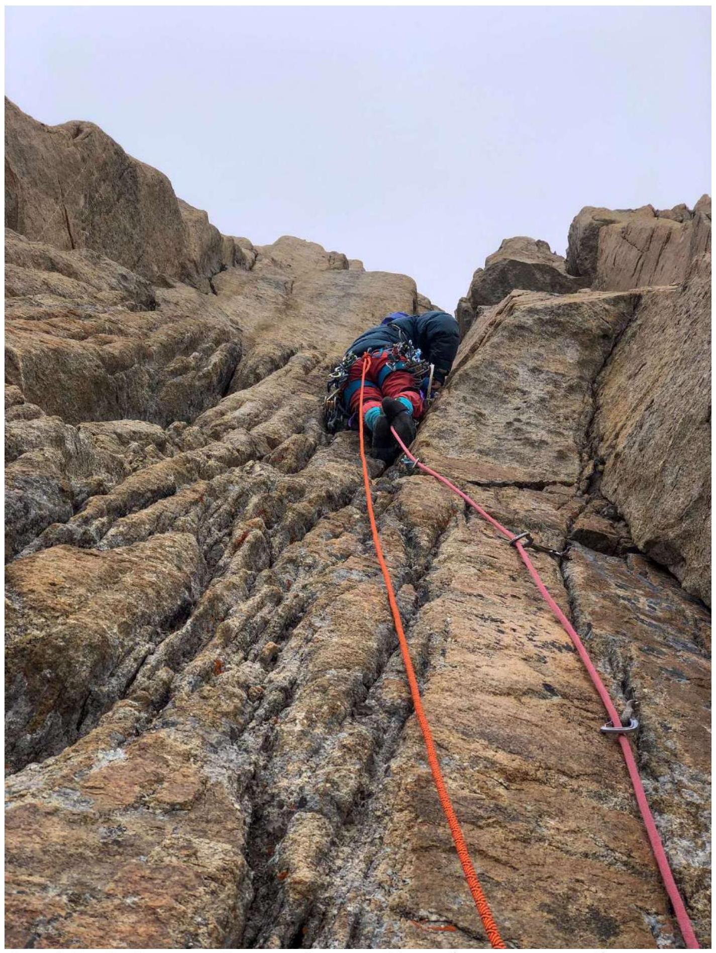
Photo 3. R7–R8. Top of the first key rope. We divided it into two to reduce rope friction
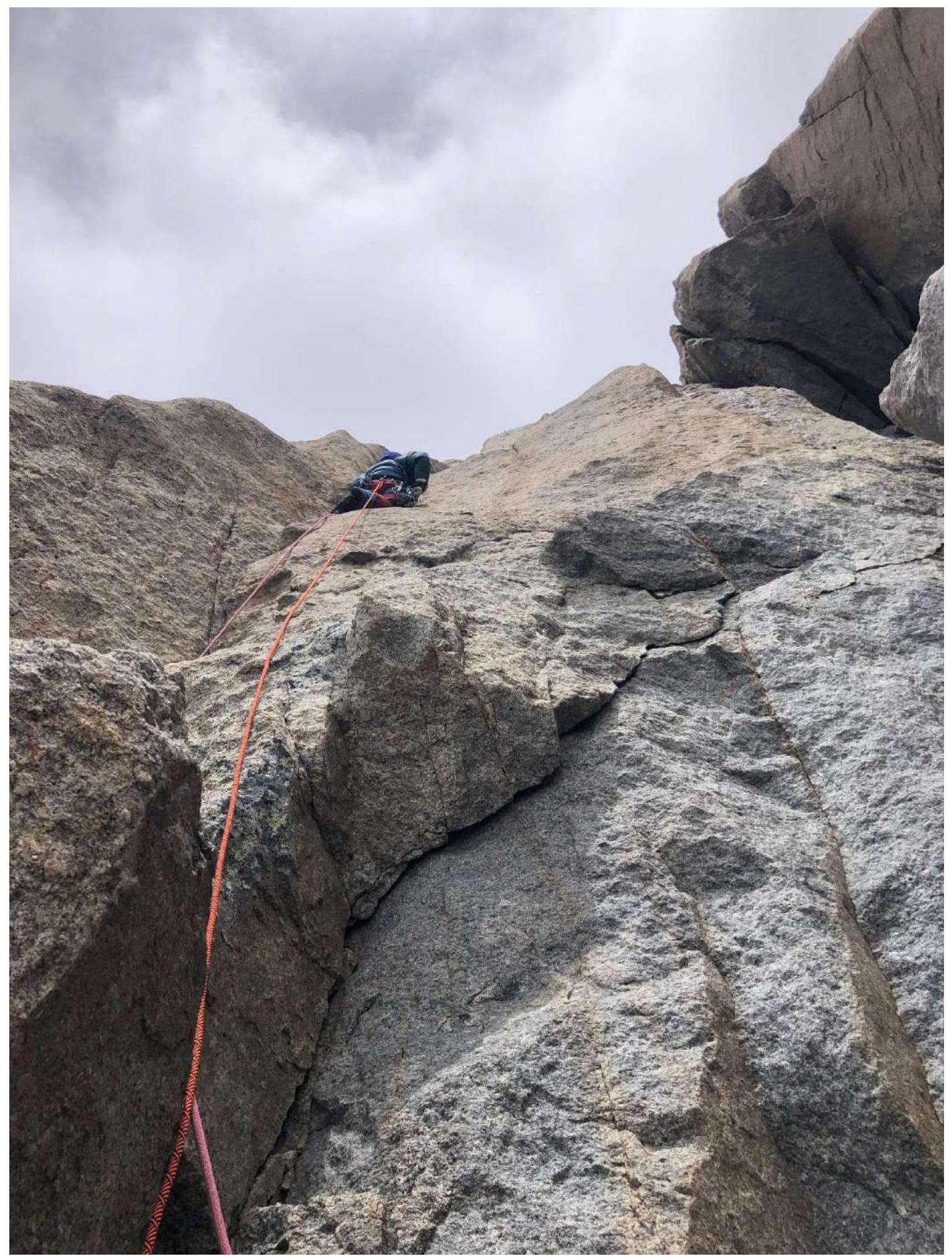
Photo 4. R8–R9. Start of the key rope

Photo 5. Exit to the “balcony” through a narrow gap (can be bypassed to the right via ledges)

Photo 6. S ridge, R11–R12
3. Characteristics of the Team's Actions
3.1. Brief description of the route passage.
The approach to the route is via a steep scree slope to the right of the rocky outcrops; there are places for overnight stay on them, but there is no water in the second half of summer. The lower part of the route (R1–R7) is not technically difficult, with short sections of category IV. After bad weather, the passage becomes significantly more complicated due to ice formation, especially on the R3–R4 section. The R4–R5 section can be bypassed to the left via a series of ledges and internal corners. Throughout the route to the ledge under the “Monk” gendarme, there are rappel anchors.
Under the “Monk” gendarme:
— a wide, comfortable ledge; — a comfortable overnight stay is possible (at least for two tents); — ice can be found in the crevices.
The main technically difficult part of the route is relatively short (2 ropes), representing a steep, monolithic rocky bastion. The first rope R7–R8 is climbed entirely via free climbing (possibly requiring a few moves on ITO), approximately 6a. The first 20 m involve uncomplicated climbing up an internal corner, followed by a traverse to the left along a ledge (5–7 m), and then upwards (possibly organizing an intermediate belay station to reduce rope friction). The higher you go, the more difficult the climbing becomes; it is possible to switch to ITO. Belaying is easily organized.
The R8–R9 section is the key to the route—a vertical, partially overhanging system of crevices climbed using ITO. There are old pitons, most of which are driven in very deeply, making it impossible to clip a carabiner into them. Midway through the rope, there is a control cairn on a “carrot”. Organizing one's own belay points is easy; friends work well. The rope leads to a ledge, and from there, a simple climb to the right leads to the wide “Balcony” ledge, where a comfortable overnight stay is possible.
From the balcony:
— traverse along the ledge to the right, around the corner—60 m; — when the ledge ends, a logical ascent up to the ridge via slabs and несложными стенками is visible.
Further, simultaneous movement along the ridge with belay organization using friends, nuts, and anchor pitons. There are ice and snow sections, requiring crampons for all participants. The “Claw” gendarme is bypassed to the left via ledges with snow and ice (connecting with Sasorov's 4B route). From here, there is an ascent up a snow-ice slope to the saddle of the S ridge. Further along simple rocks, traverse along the ridge, a 5 m descent down a steep wall (where a local rope is hung), and an ascent to the summit tower.
Descent is along the S ridge via V. Ruzhevsky's 5A route (“monk”), with many rappel stations and anchors. The first rappel is best done 10 m before the end of the ridge (bolted anchors). After about 35 m, you need to move to the right, around the corner, where there will be an intermediate station on pitons, from which a rappel is made to the “balcony”. On the edge of the “balcony” and below the rope, there are bolted anchors linked by a steel cable.
The route is very logical. The key ropes are interesting, monolithic, with good belays. The route is suitable as a first 5B, serving as training for more difficult routes.
3.2. Photo of the team on the summit at the control cairn
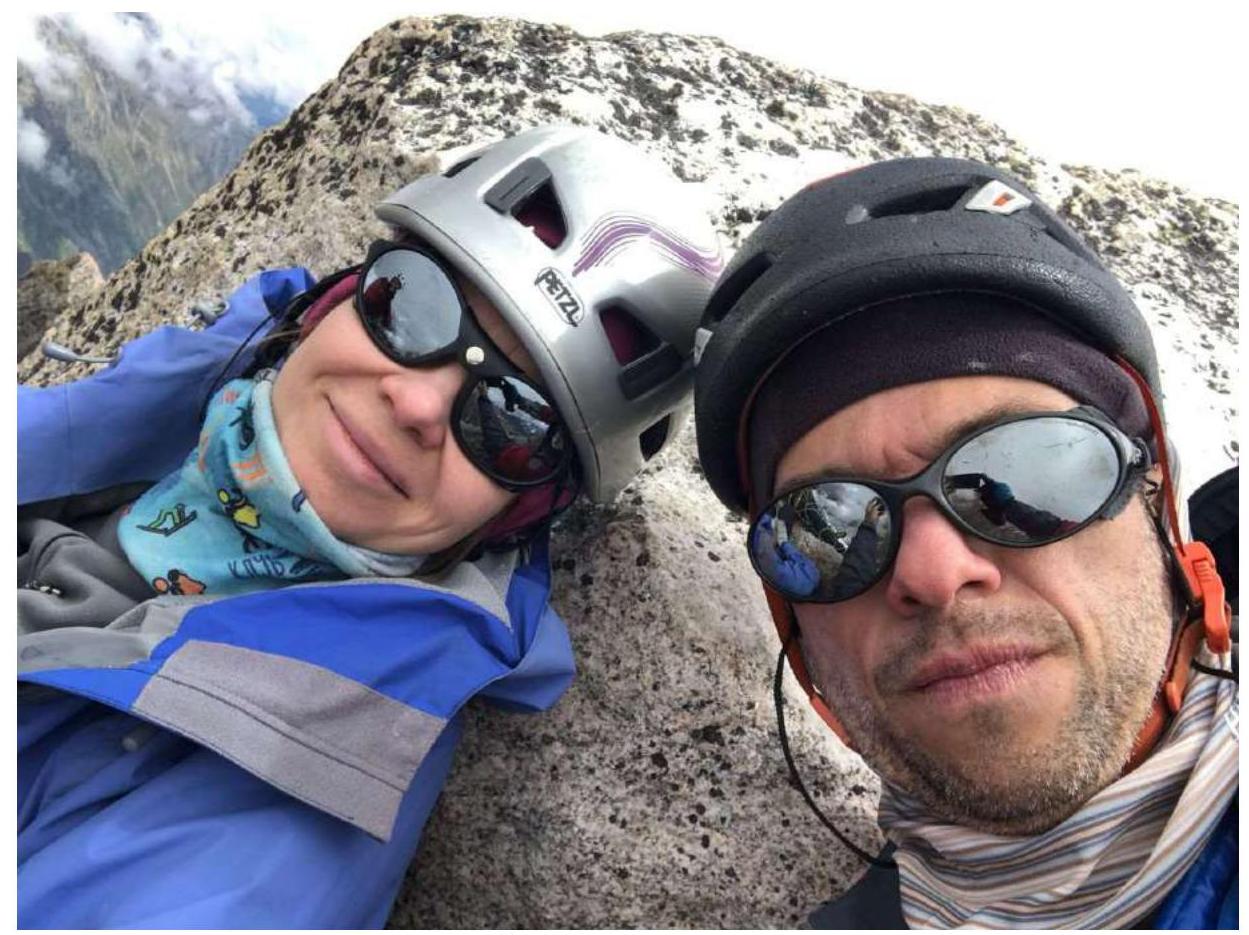
Photo on the summit
4. Characteristics of Weather Conditions
On July 24, 2024, it was cold, without precipitation. Around 14:00, wet snow and rain started.
On July 25, 2024, it was cold in the morning, without precipitation. The sun reached the rocks around 12:00. After 15:00, wet snow started again.
5. Tactical Actions of the Team
The route was started at 6:40 because the team ahead, Kravchenko–Shchekinova, was climbing via Li's 5B route.
We reached the ledge under the “monk” around 9:30. The weather was deteriorating, with forecasts predicting rain in the afternoon. Continuing to the ridge and the summit of Jailyk in bad weather seemed dangerous due to the potential for a thunderstorm, so it was decided to set up a bivouac on the ledge and process the two key ropes. Processing was completed by 14:00, and the team descended to the tent already in bad weather.
The next day:
— Climbed the fixed ropes; — Reached the S ridge by 11:00; — Reached the summit at 13:07.
The entire route, except for the walking part of the S ridge, was led by Irina Vasilyeva, as she planned to climb 6A Forostyan on Chegem afterwards and needed to warm up.
On this day, we descended via rappels along Ruzhevsky's 5A route to the tent on the ledge and did not descend further due to deteriorating weather and to avoid being caught in the dark. The next day, we descended to the start of the route and to the UlLu-Tau alpine camp.
The ascent went smoothly and calmly, according to plan. The main goal of the ascent—to warm up before 6A Forostyan—was achieved. The tactical plan was made based on the weather forecast, aiming to reduce objective risks.


