Passport
I. Category — technical. 2. Main Caucasian Range and its spurs from Chipperaza pass to Ortokara peak. 3. Bashil peak, 4257 m, center of the South wall bastion. 4. Proposed 5B category of difficulty first ascent. 5. Height difference: 800 m.
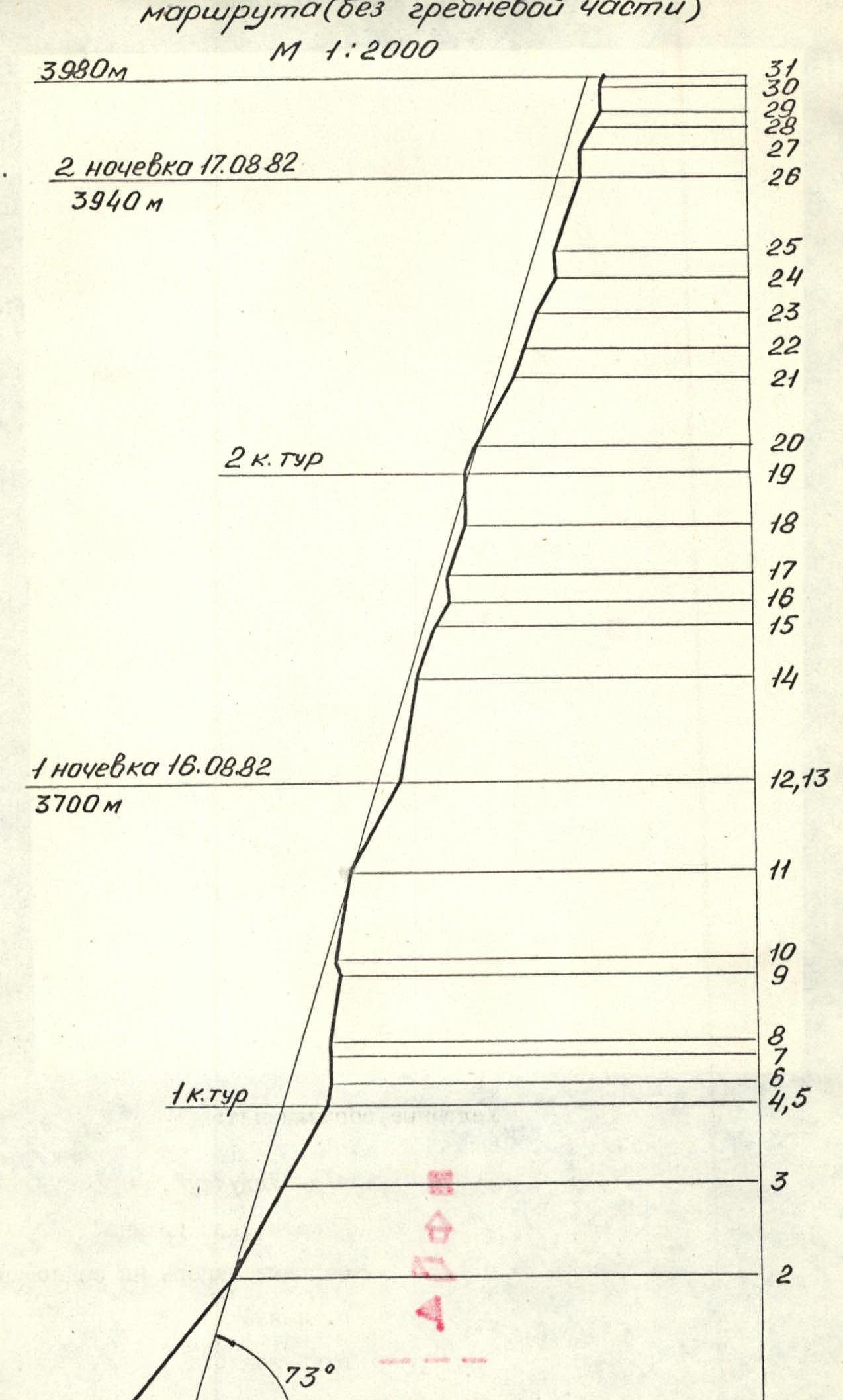
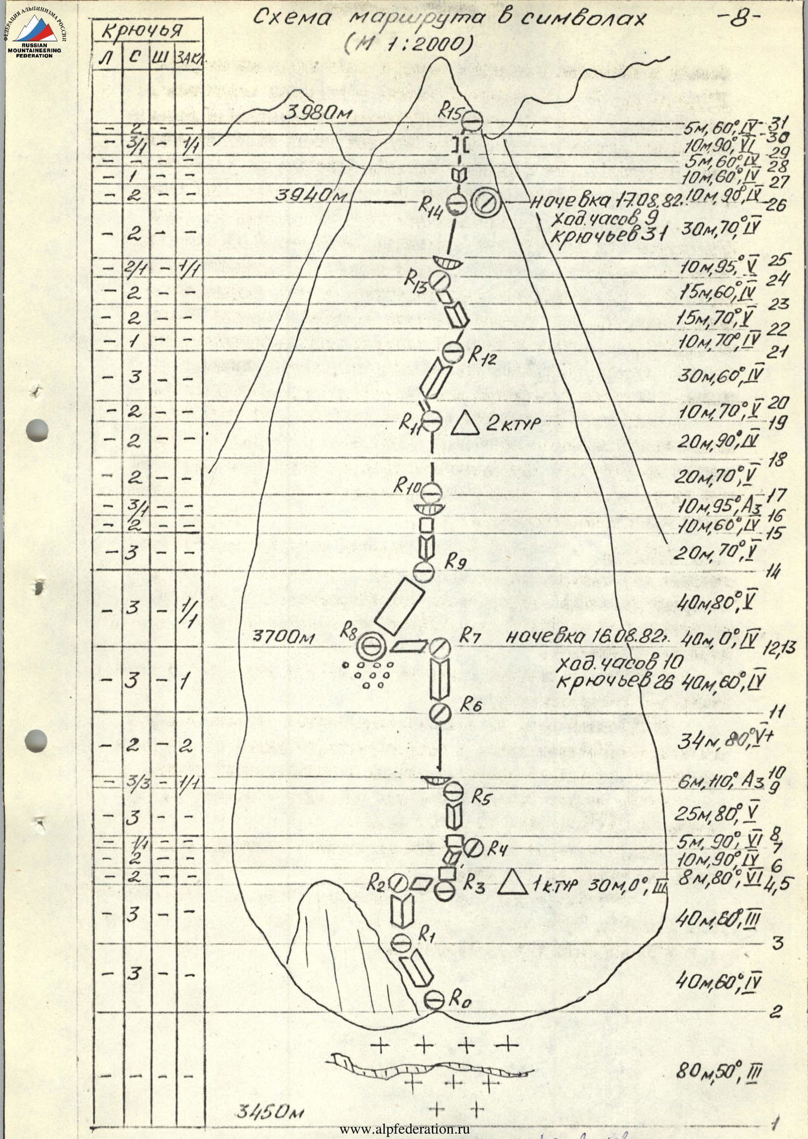
Length: 1050 m. Length of 5–6 category of difficulty sections: 215 m. Average steepness of main sections: 73° (3510 m–3980 m). Including 6 category of difficulty — 40 m (3580 m–3900 m), 93°.
- Pitons driven:
| rock | bolt | chocks | ice |
|---|---|---|---|
| 69 / 6 | 0 / 0 | 7 / 4 | 5 / 6 |
- Team's climbing hours: 24 (excluding descent) and days — 3.
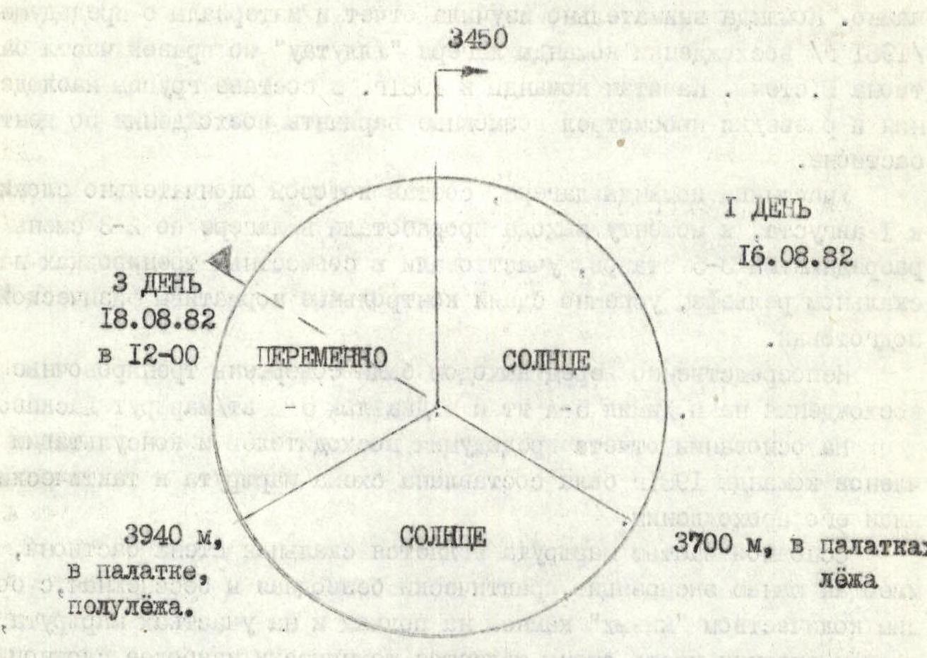
- Overnights: 1 — on a scree ledge in tents, 2 — on a rock ledge, semi-reclined in a tent.
- Team leader: Alexander Valentinovich Rasskazov, Master of Sports of the USSR.
Team members:
- Alexander Georgievich Kurochkin, Candidate Master of Sports of the USSR
- Vladimir Ivanovich Egorov, Candidate Master of Sports of the USSR
- Petr Ivanovich Dementiev, Candidate Master of Sports of the USSR
- Valery Nikolaevich Pyltsin, Candidate Master of Sports of the USSR
- Yuri Ivanovich Shortov, Candidate Master of Sports of the USSR.
-
Coach: Kim Kirillovich Zaitsev, Master of Sports of the USSR.
-
Start of the route: August 14, 1982. Summit: August 18, 1982. Return: August 18, 1982.
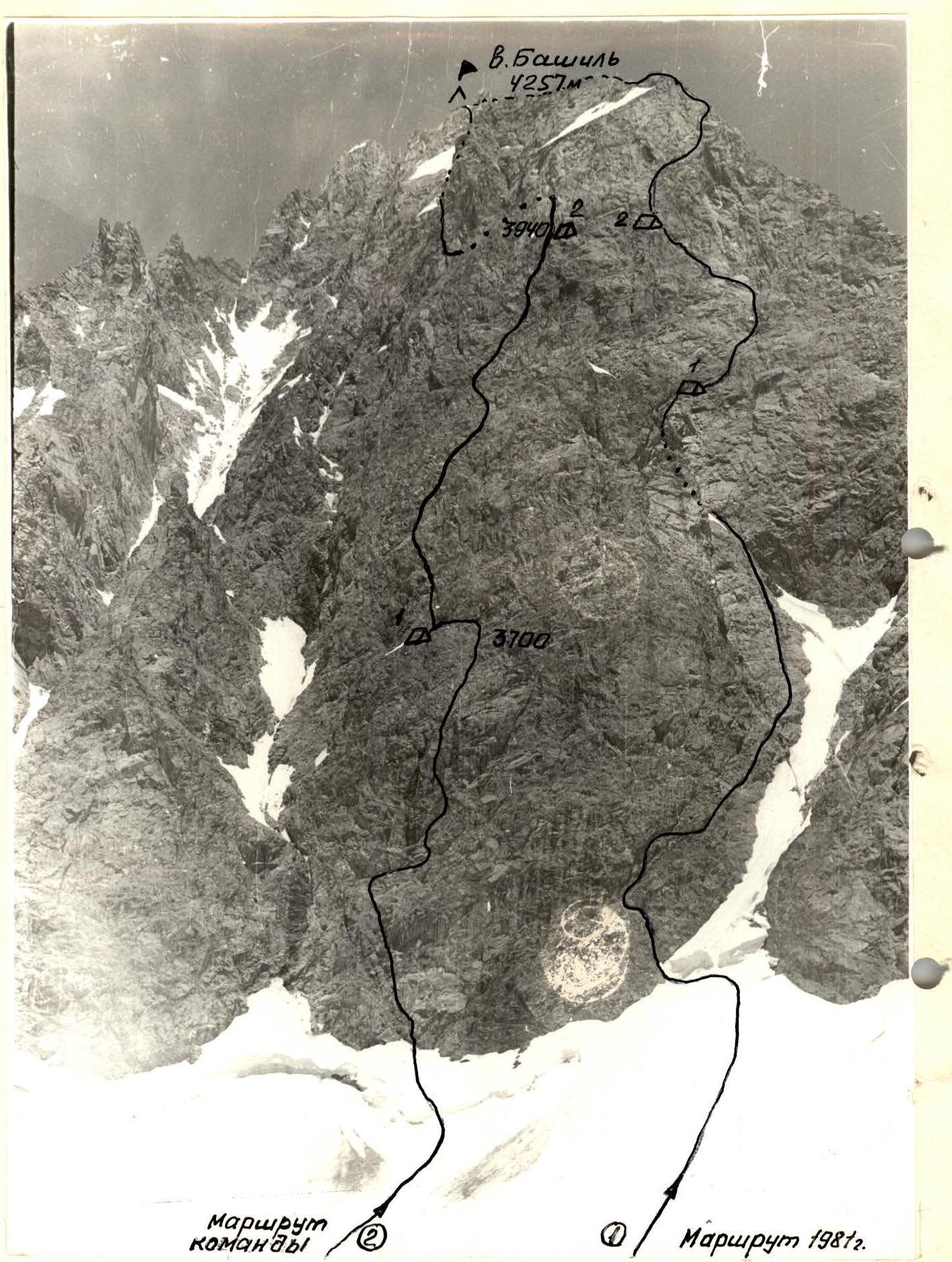
General photo of Bashil peak's South wall on July 22, 1981, distance 1500 m from the summit, from Dzinál, lens "Helios-44" f = 58 61 3450 m
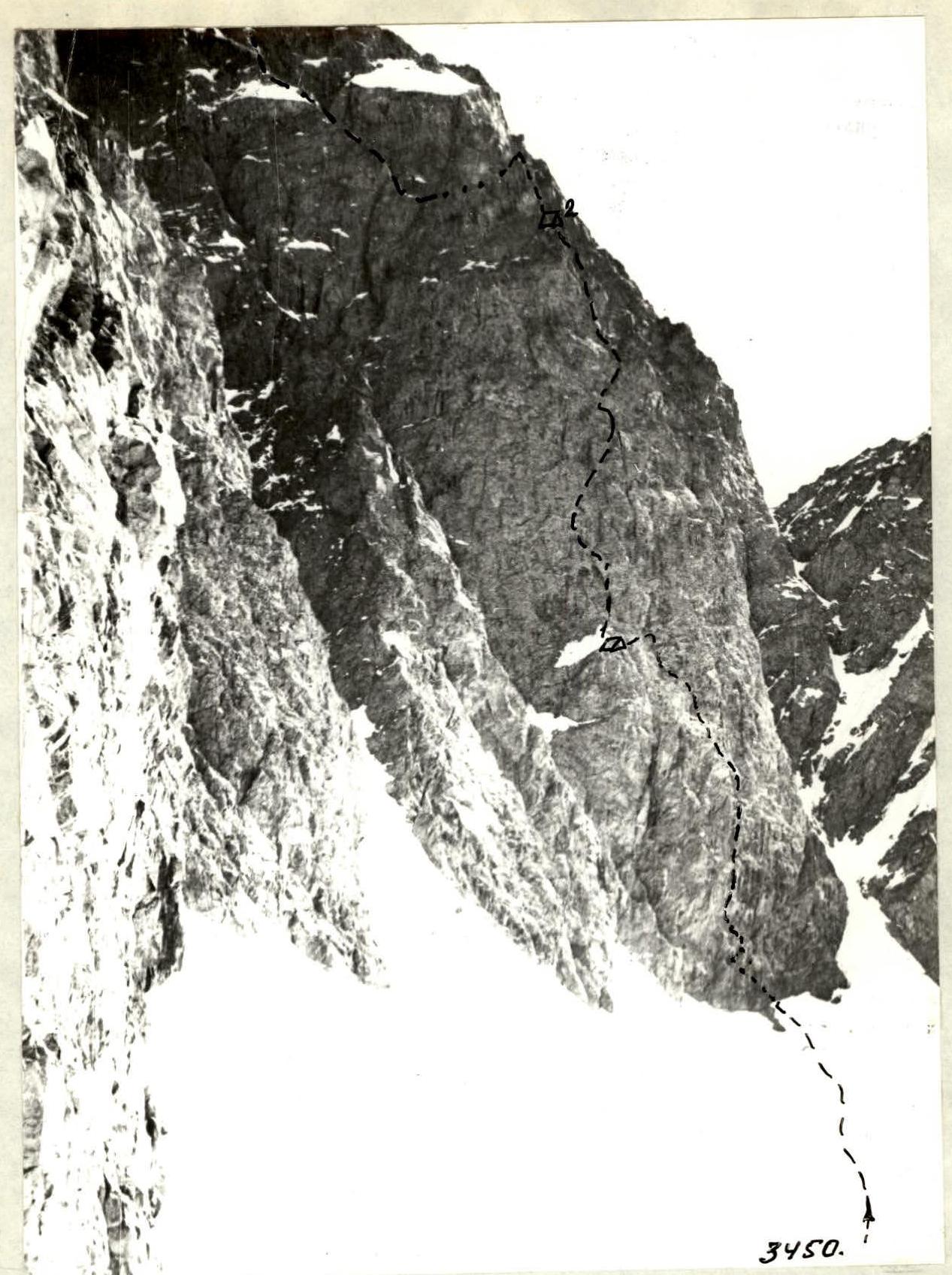
Photo 2. Profile of the bastion's wall on Bashil peak's South wall from the 103 ridge. August 15, 1982, distance 1000 m from the summit 61 3600 m, lens "T-43 4/40 'Domo'"
Profile scheme of the wall section of the route (excluding ridge section)
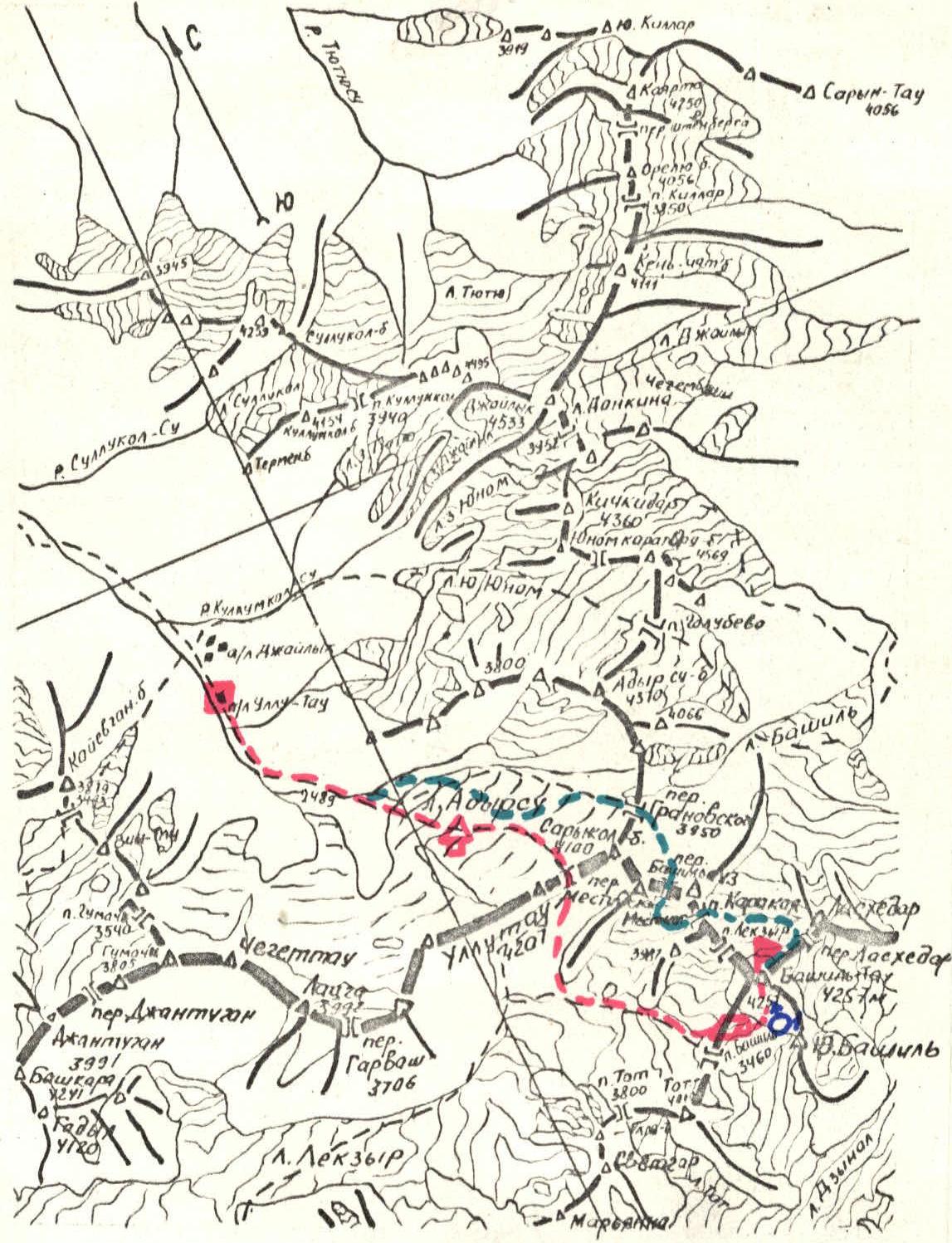
Area map
1:100000
Conventions:
- "Ullutau" alpine camp
- "Mestia hut" — base camp on the saddle
- Bashil peak — approach route
- return route
Brief overview of the ascent area
Bashil peak (4257 m) is a key peak of the Main Caucasian Range in the upper reaches of the Chegem River, located between:
- Laskhedar pass, and beyond it, the eponymous peak to the east;
- Lekzyr pass, further to Karakaya pass and Karakaya-Lekzyrskaya peak to the northwest.
Two ridges extend from Bashil peak — Southwest and South.
- The Southwest ridge descends to Bashil pass, behind which stands Tot peak.
- On the South ridge is located the South Bashil peak.
On Bashil peak, four ridge routes of 3A category of difficulty (along the S, SW, E, and NW ridges) and two wall routes: 5B category of difficulty along the West wall and 5A category of difficulty along the right part of the South wall bastion have been laid.
To the south, east, and north, Bashil peak is bounded by sheer walls. Currently, the area is relatively infrequently visited by climbers.
The history of the peak's conquest, description of the approach routes are detailed in the book by A.F. Naumov "Chegem–Adyrsu", pp. 190–193.
The initial bivouac for the ascent is located on the saddle of the Southwest ridge of Bashil peak (7–8 hours from "Ullutau" alpine camp).
Preparation for the ascent
Bashil peak was not chosen as the object of ascent by chance. The team carefully studied the report and materials from the previous (1981) ascent by the team from "Ullutau" camp along the right part of the South wall bastion. The team captain in 1981, as part of an observation and reconnaissance group, examined possible ascent options along the center of the bastion.
Team members, whose final composition was established by August 1, worked in the camp for 2–3 shifts with 3rd to 5th stage trainees, participated in joint training on rock terrain, and successfully passed physical fitness control standards.
Immediately before the departure, they made training ascents to Pik Khimik 5A category of difficulty and Dzhailyk peak 5B category of difficulty (Laskavy's route).
Based on the report of previous climbers and consultation with team members from 1981, a route scheme and tactical plan for its passage were drawn up.
The main part of the route is a rock wall of the bastion, with a southern exposure, practically waterless and snowless, with a large number of "live" stones on the ledges and route sections, with the middle part of the wall being technically the most challenging due to overhanging sections.
No spontaneous stonefall was observed on the route according to the 1981 reconnaissance results.
The main danger on the route is posed by "live" stones and entire blocks, requiring constant attention to safety measures by all team members. For this reason, it was decided to exclude the practice of pulling team members' backpacks and to avoid large stretching when passing sections on belay lines.
Ascent schedule
Team's tactical actions
August 14, 1982. Team departure from "Ullutau" alpine camp at 16:00. At 19:30, they stopped at a bivouac in the "Mestia hut".
August 15. Departure from the hut at 6:00. At 11:00, they reached the saddle of the Southwest ridge of Bashil peak, where the initial bivouac was set up: 2 tents were installed (1 — on a scree site, 2 — on snow).
The rest of the day was used to clarify the ascent route, its inspection, and photography.
August 16. Departure from the bivouac at 7:30. After linking up, they moved along the Dzinál glacier and then along the ice-firn slope (1–2) with intermittent belay via ice axe, approaching the start of the route. They moved in teams:
- Egorov—Rasskazov
- Kurochkin—Dementiev
- Shortov—Pyltsin.
In the process, team members were rotated, and on certain sections, the lead was changed.
On this day, Egorov V.I. primarily worked on the route in galoshes and with a lightened backpack.
After passing 80 m along an internal corner with intermittent belay, they made a traverse to the right (R4–R5), securing the rope at the end of a ledge on a convenient platform, where they set up 1 control cairn. Then Egorov began to pass:
- a vertical 8-meter slab (R4–R5)
- an internal corner R6–R7.
At the end of the internal corner is a small platform-outcrop.
At this point, Egorov had to wait for the other team members to pass the R2–R4 section, as this section was bombarded with stones from the R6–R7 corner. At this and subsequent sections, each climber trailing behind cleaned the route of loose stones and blocks.
After passing the R7–R9 section, they reached a convenient platform where the entire group gathered while Egorov, belayed by Rasskazov, passed one of the key sections of the route — an overhanging 6-meter rock section with few holds and cracks. After passing it and a steep section R10–R11, Egorov set up belay lines, which the others climbed using jumar.
The R11–R12 section (a wide internal corner-gutter) was passed by the Dementiev—Egorov team with belay lines, and while the others were passing it, they moved ahead to scout a path along the reddish sheer counterfort, somewhat protruding from the main wall of the bastion. At this time, the Shortov—Pyltsin team traversed 40 m to the left to scout a possible bivouac site (time — 16:30).
On a wide scree shoulder with a snowpatch on the edge, it was decided to set up a bivouac. Simultaneously, a more logical further path was found — from the shoulder to the right and upwards along the left part of the reddish counterfort. They rappelled and set up 2 belay lines, then descended to the bivouac.
August 17. At 9:00, the Kurochkin—Rasskazov team ascended via the hung belay lines (section R13–R17), and Kurochkin, with Rasskazov's belay, continued the ascent. The upper part of the bastion is also heavily destroyed, with many "live" stones. The main direction of movement is to the right and upwards towards the summit of the bastion to a small shoulder R26 on the edge of the couloir bounding the bastion to the right. From the shoulder, Kurochkin passed upwards section R26–R31 — one of the key sections of the route, and the Egorov—Rasskazov team, having ascended via the hung belay lines, conducted a reconnaissance and assessment of the further path. It was decided:
- to bypass the summit of the bastion to the right;
- with a descent into the large snowy couloir bounding the bastion to the right;
- at the level of the rock ridge-bridge connecting the bastion to the South wall, which is the summit of the couloir.
Since no potential overnight sites were visible on the visible section of the ridge, at 17:00, it was decided to set up belay lines on sections R31–R34 and stop for a bivouac on the shoulder R26, where a tent was installed on a destroyed ledge (for 6 people — semi-reclined overnight).
August 18. Departing from the bivouac at 8:00 and passing the hung belay line sections, they reached the rock ridge-bridge (R34–R35), along which they moved in teams with simultaneous, and in some places — intermittent belay. Teams:
- Rasskazov—Pyltsin
- Egorov—Shortov
- Kurochkin—Dementiev.
At the junction of the ridge with the South wall, a 3rd control cairn was suspended in a bank.
The further path along a largely snow-covered terrace-shoulder, first upwards, then to the left to the edge of the terrace, and then along destroyed rocks to the South ridge, was traversed with the establishment of belay lines.
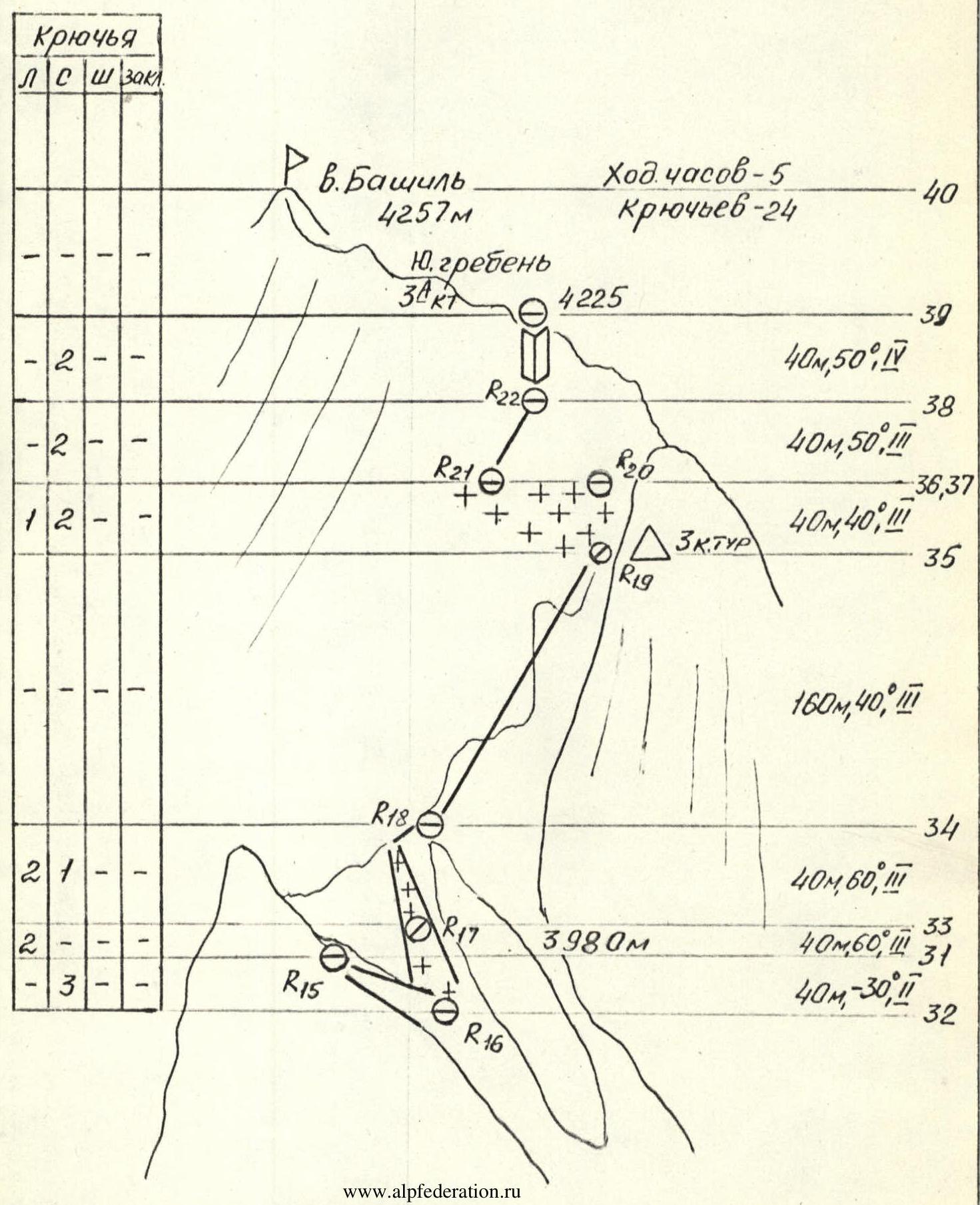
Along the South ridge (3A category of difficulty route), they moved in teams to the summit. They reached the summit at 12:00.
The descent along the East ridge to Laskhedar pass took 2 hours (along the 3A category of difficulty route).
After descending to the left of the pass onto Bashil glacier, through Karakal, Banilauz, and Granovskogo passes, they descended into Adyrsu valley and were back at "Ullutau" alpine camp by 19:00.
Continuation
Total:
- climbing hours — 24
- pitons used — 81
From the initial overnight on the saddle of the SW ridge, 500 m down along the gently sloping Dzinál). The start of the route is marked by an internal corner that ascends to the left and upwards from the middle part of the bastion's base behind a rock outcrop.
Along an 80-meter ice-firn slope (1–2) with a steepness of up to 50°, having crossed a bergschrund via a snow bridge, ascend to a rock ledge at the beginning of the internal corner.
Along an 80-meter internal corner-gutter (R2–R4), in the lower part with a steepness of up to 60°, in the middle — up to 50°, and at the exit — up to 90°, with a large number of "live" stones along the entire length of the gutter, with piton belay, ascend to a steep rock ledge (R4–R5) that extends horizontally to the right.
Along the ledge, 30 m to the right to a scree shoulder. Here, for orientation, the start of the route is marked by 1 CONTROL CAIRN.
From the shoulder upwards along an 8-meter slab (R5–R6), ascend (few holds, 5–6 category of difficulty) to a narrow ledge, along which 4–5 m to the left and then to the right and upwards along an internal corner (R6–8) with "live" stones 10 m upwards to a small platform-outcrop.
From the platform, 5 m along a 90-degree wall R7–R8 (ladder steps) to a kink and then along an 80-degree internal corner R8–R9 to the right and upwards 25 m, bypassing a plug of stones in the upper part, to a small platform where the entire group can gather.
From the platform, straight upwards, overcoming an overhanging (100–110°) section R9–R10 with a length of 6 m (ladder steps) with few holds and cracks, exit to a steep rock section R10–R11 (80°, 34 m) with a limited number of holds, consisting of:
- walls
- monolithic blocks, leading to the beginning of a wide vertical internal corner-gutter R11–R12 (40 m, 60°), formed by rocks resembling "rams' foreheads" with scree ledges on them and numerous "live" stones.
Along the corner, exit to a narrow horizontal ledge under the base of the reddish counterfort-wall, somewhat protruding from the main wall of the bastion.
Along the ledge, 40 m to the left (R12–R13) to an inclined scree shoulder with a width of 8–10 m and a length of 25–30 m, with a snowpatch on the edge.
On the scree part of the shoulder, 2 OVERNIGHT PLATFORMS are laid out.
From the upper part of the shoulder, a 40-meter triangular reddish wall R13–R14, with a sufficient number of holds and "live" stones, leads to the beginning of a 20-meter internal corner R14–R15, which exits onto a rock ledge R15–R16, passing above the overnight site and ending in an overhanging section R16–R17, overcome with ladder steps. Above the overhanging section is a small ledge.
From the ledge, along heavily destroyed rocks, initially with 70-degree steepness (R17–R18), and then up to 90° (R18–R19) — exit to a wide scree ledge under the reddish tower, where the 2nd CONTROL CAIRN is set up on the left.
From the ledge, along a 10-meter crevice R19–R20 to the left and upwards, then to the right and upwards 30 m along a steep internal corner R20–R21 with plugs of "live" stones in it, ascend to a small platform.
From the platform, to the right and upwards 10 m along a steep ridge R21–R22 of destroyed rock blocks, then along an internal corner R22–R23 to the left and upwards 15 m, and along a steep rock ledge R23–R24 15 m to an outcrop under the overhanging reddish wall in the upper right part of the bastion.
From the outcrop, an overhanging section R24–R25 10 m, transitioning further into a section of destroyed rock blocks R25–R26, leading to a small shoulder. Here is a site for setting up a BIVOUAC.
From the shoulder, along a steep rock ridge R26–R27 10 m to a steep internal corner R27–R28 with a jammed rock slab in its upper part, and along a steep 5-meter rock ridge R28–R29 — exit to a sheer 10-meter chimney R29–R30 with few holds, ending in a 5-meter ledge R30–R31, leading to a ledge to the right of the pointed summit of the bastion.
The summit of the bastion is bypassed to the right at the level of the visible rock bridge behind it, connecting the bastion to the South wall.
From the ledge, descend via rappel to the right, towards the large couloir, first along a 3-meter rock wall, then along a snowy-icy gutter-couloir 40 m to its confluence with the large couloir bounding the bastion to the right (R31–R32).
Adhering to the left part of the couloir, ascend along the ice (in the upper part — snowy) slope R32–R34 80 m to a narrow snow-covered bridge, which is the summit of the couloir. Belay — using ice screws.
From the snow bridge begins a rock ridge R34–R35 of heavily destroyed rock blocks 150–160 meters, leading to the upper part of the South wall. Movement along the ridge is:
- simultaneous
- individual sections — with intermittent belay.
At the junction of the ridge with the South wall, to the right on the wall, a 3rd CONTROL CAIRN is suspended in a bank.
From the cairn, bypassing the summit tower of the South wall to the left, exit onto a large snow-covered terrace, which is traversed to the left and upwards (R35–R37) towards its edge.
From the edge of the terrace, along heavily destroyed rocks 80 m (R37–R39) to the exit onto the South ridge (3A category of difficulty route).
Along the ridge of moderate difficulty, overcoming several sentinels head-on, with intermittent or simultaneous belay (5–6 ropes) — exit to the summit of Bashil.
Descent from the summit along the East ridge (3A category of difficulty route):
- initially along a steep rock ridge (50 m)
- then along a snowy slope
- 2 sport descents along rocks to a snowy slope extending to the left from the E ridge
- descent onto Bashil glacier under Laskhedar pass (2 hours from the summit).
From the glacier, through Karakal, Banilauz, and Granovskogo passes — return to "Ullutau" alpine camp.
From Laskhedar pass — 5–6 hours.
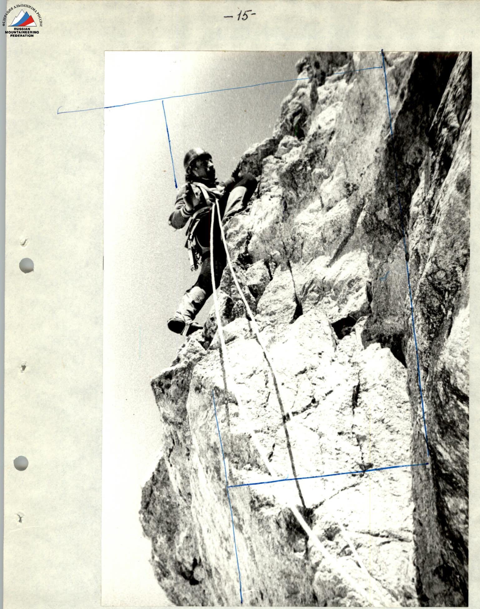
Photo 4. Exit from section R9–R10.