The Main Caucasian Range and its spurs from Chipperaza pass to Ortokara peak
Report
on the first ascent to Adyrsu peak (4370 m) via the South-West wall through the central bastion from July 19 to July 22, 2008, by the AUSB "Ullutau" sports team consisting of:
- Monayenkov E.I. — team leader
- Bulocnikov V.S. — team member
- Sandin S.A. — team member
AUS "Ullutau" 2008
Addresses
AUS "Ullutau": 361602, KBR, Nalchik, ph. 8 (8662) 77–09–87
Team Leader (report inquiries): 142101, Moscow region, Podolsk, 44a-17, Pleshcheevskaya st., Monayenkov E.I. Ph. 8 (343) 348–44–60 Mob. 8–922–100–82–25
Coach: 360017, KBR, Nalchik, 12, Kirova st., apt. 50, Porokhnya Yu.I. Ph. 8 (8662) 74–08–65
The heights mentioned in the report were determined visually and with a 50-meter rope.
Passport
- The Main Caucasian Range and its spurs from Chipperaza pass to Ortokara peak, Adyrsky ridge, Adyrsu gorge. Section number according to the 2001 classification table: 2.4.1.
- Peak name: Adyrsu (4370 m) Route name: via the South-West wall through the central bastion
- Route category: proposed — 5B category, first ascent
- Route type: combined
- Route height difference: 870 m
Route length: 1195 m
Section lengths:
- 5B category — 455 m
- 4 category — 560 m Average steepness of the main part of the route — 65 ° Total route — 57 °
- Pitons left on the route: total — 1 заклад.; shlyam — 0.
Pitons used on the route:
- shlyam stationary — 0 (including ИТО — 0)
- shlyam removable — 0 (including ИТО — 0)
- artificial points of support (ИТО) used — 0
- rock cams ice: 24/7, 0/0, 82/23, 33/9
- Team's walking hours: 27.5 hours (not including descent) and days — 3.
Overnights:
- first — on top of the bastion on a ledge in a tent
- second — before reaching the summit ridge, sitting.
- Team Leader: Monayenkov Evgeny Ivanovich — МС
Team members:
- Bulocnikov Vladimir Semenovich — КМС
- Sandin Sergey Alekseevich — 1st sports category
- Coach: Porokhnya Yuri Ivanovich — ПМС USSR
- Departure to the route: July 19, 2008 Summit ascent: July 22, 2008 Return to the base camp: July 22, 2008
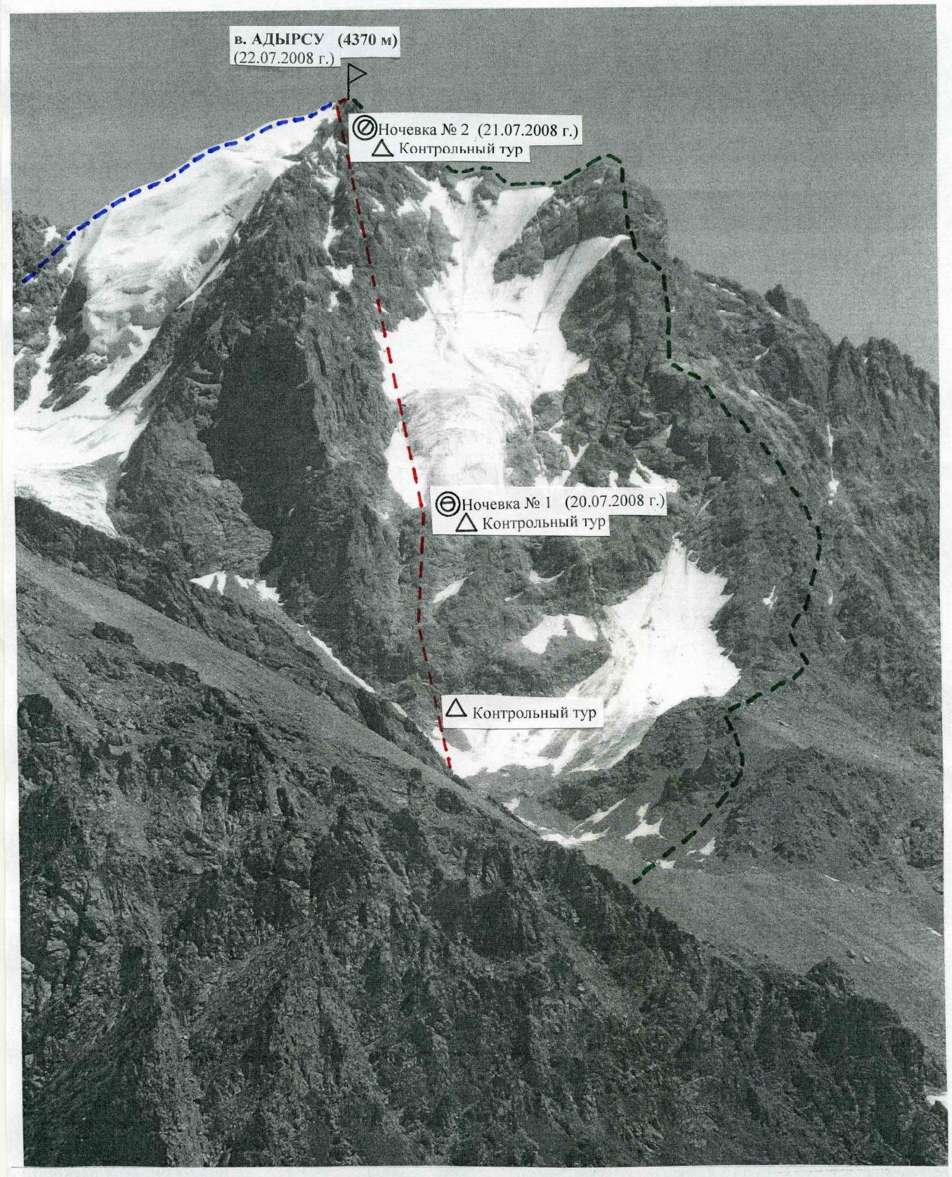
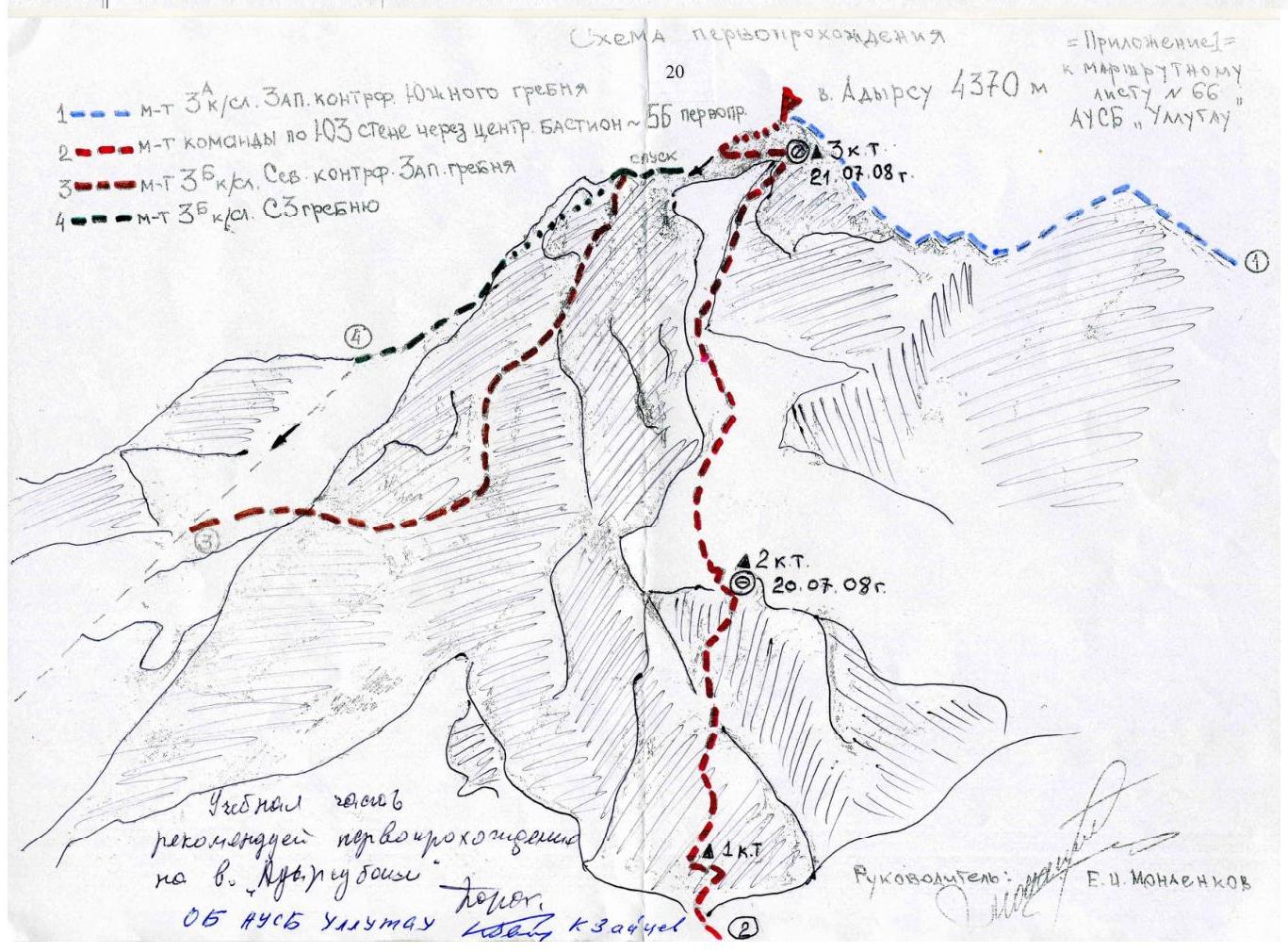
Photo 2. General view of the route:
- 3B category, D. Kokkin's route, via the NW ridge
- 5B category, team's route, first ascent via the SW wall
- 3A category, Vyal'tsev's route, via the West counterfort of the South ridge
Brief overview of the climbing area and history of Adyrsu peak (4370 m) ascents
The heavily branched Adyrsky ridge branches off to the north from the nodal peak of the Main Caucasian Range — Sarykol, separating the Chegem gorge from the side gorges of the Baksan valley — Adyrsu, Tyutyusu, Sakashil. The ridge is the watershed of the Chegem and Baksan rivers.
Adyrsu peak (4370 m) is a nodal peak of the Adyrsky ridge, located between Sarykol peak (behind the Granovsky pass) to the south and Orubashi peak (behind the Gubieva pass) to the northeast. Translated from the Balkar language, Adyrsu-bashi means "steep mountain". The first ascent was made in 1896 by D. Kokkin via the North-West ridge.
According to the "Classification of Routes to Mountain Peaks" by the Russian Mountaineering Federation (2001 edition), there are 6 routes to Adyrsu peak, including 3 training routes of 3A-3B category (3 sports routes of 4A, 4B, 5A category).
One of the most beautiful peaks in the gorge is very popular among climbers and has various routes. In terms of technical difficulties, it is interesting for fulfilling the norms for 1st-2nd sports categories. When tactically preparing, it is necessary to consider this factor.
According to the ascent participants, the route taken by the team via the South-West wall through the central bastion may become quite popular among athletes when performing the norms for the Candidate Master of Sports, as it is combined, relatively safe, and allows for a safe bivouac on rock ledges when passing the bastion.
Route diagram in UIAA symbols, part 1
Route diagram in UIAA symbols, part 2
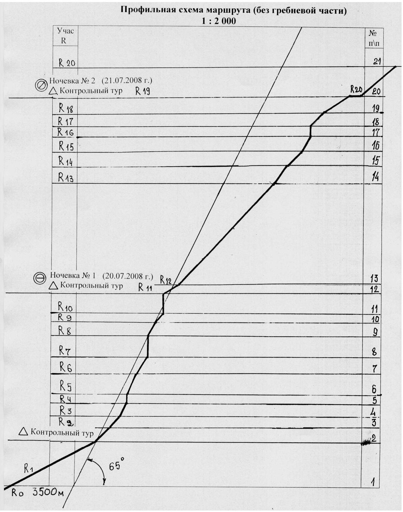
Profile diagram of the route (without the ridge part) 1:2000
| Section | Description | Length, m | Steepness, ° | Category |
| :------ | :------------------------------------------------------------------------------------------------------------------------------------------------------------------------------------------------------------------------------------------------------------------------ | :--------
over- | :------- | :---------- | :------- |
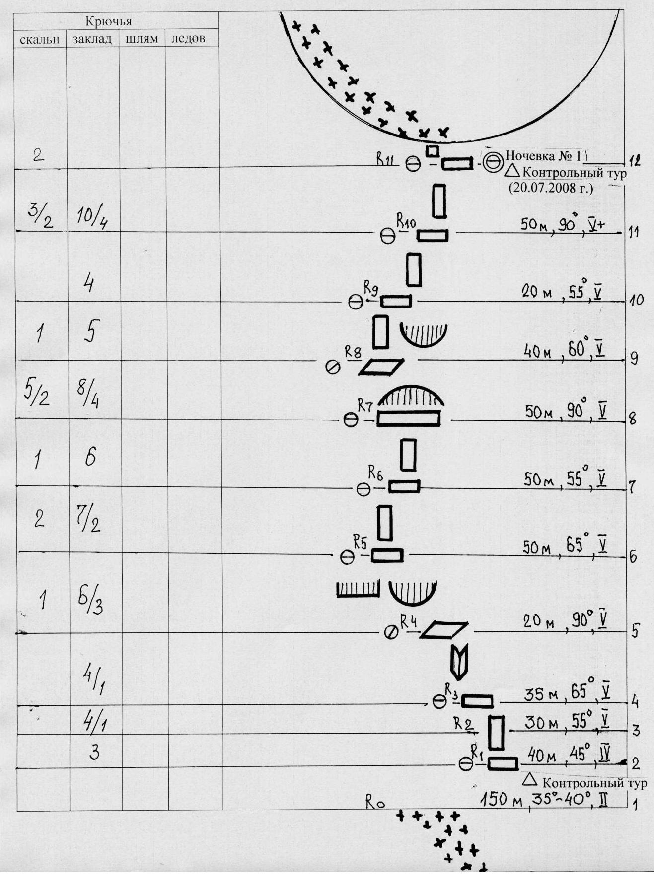
| R0–R1 | From the moraine to the lower part of the bastion via a steep snow-ice slope to a ledge. 1st control tour. | 150 | 35–40 | 2 |
| R1–R2 | Straight up the wall. | 40 | 45 | 4 |
| R2–R3 | Up and left via rocks. | 30 | 55 | 5 |
| R3–R4 | From the ledge, ascend via the internal corner to the next station. | 35 | 65 | 5 |
| R4–R5 | Ascend up and right, then left — passage between the cornice and overhang. | 20 | 90 | 5+ |
| R5–R6 | Via the wall to the next station. | 50 | 65 | 5 |
| R6–R7 | Reach a large ledge 15 × 17 m. | 50 | 55 | 5 |
| R7–R8 | Bypass the overhang from the left and via an inclined slab under the wall — complex climbing. | 50 | 90 | 5+ |
| R8–R9 | Ascend via the wall to a good ledge. | 40 | 60 | 5 |
| R9–R10 | From the ledge, ascend via the wall. | 20 | 55 | 5 |
| R10–R11 | Complex climbing to the overnight location. First overnight (July 20, 2008). 2nd control tour. | 50 | 90 | 5+ |
| R11–R12 | From the overnight location, exit left to the top of the bastion to the snow-ice slope. | 30 | 35 | 2 |
| R12–R13 | Via the snow-ice slope, approach under wet, destroyed rocks. | 350 | 45–50 | 4 |
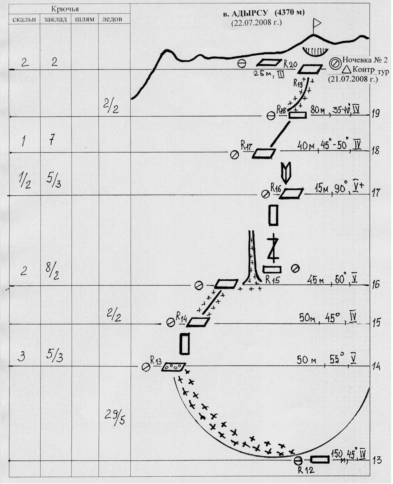
| R13–R14 | Via destroyed rocks to the snow-ice ridge. | 50 | 55 | 5 |
| R14–R15 | Via the snow ridge to the start of a narrow couloir filled with snow and ice. Cross the couloir to the right for 20 m. | 50 | 45 | 3 |
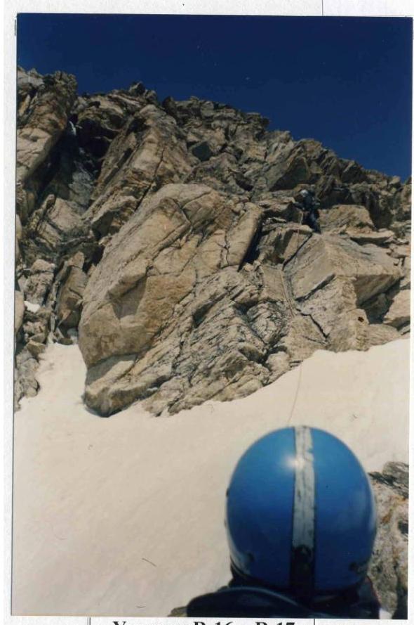
| R15–R16 | Via a crack, ascend to an internal corner. | 45 | 60 | 5 |
| R16–R17 | Via a steep internal corner, ascend to the rocks of the ridge part of the route. | 15 | 90 | 5+ |
| R17–R18 | Via the rock ridge, approach the snow-ice "knife". | 40 | 45–50 | 4 |
| R18–R19 | Via the snow "knife" to a large square rock, bypass it from the left and right under the overhanging rock. Second overnight (July 21, 2008). 3rd control tour. | 80 | 35–40 | 3 |
| R19–R20 | From the overnight location, exit left via destroyed rocks to the NW ridge. Via the snow ridge (cornices) approach the pre-summit ascent. After crossing the bergschrund, exit to a simple rock ridge and ascend to Adyrsu peak. Control tour R20. Overnight #2 (July 21, 2008) | 25 | 35–40 | 3 |
| R20–R21 | (Empty section to the summit) | | | |
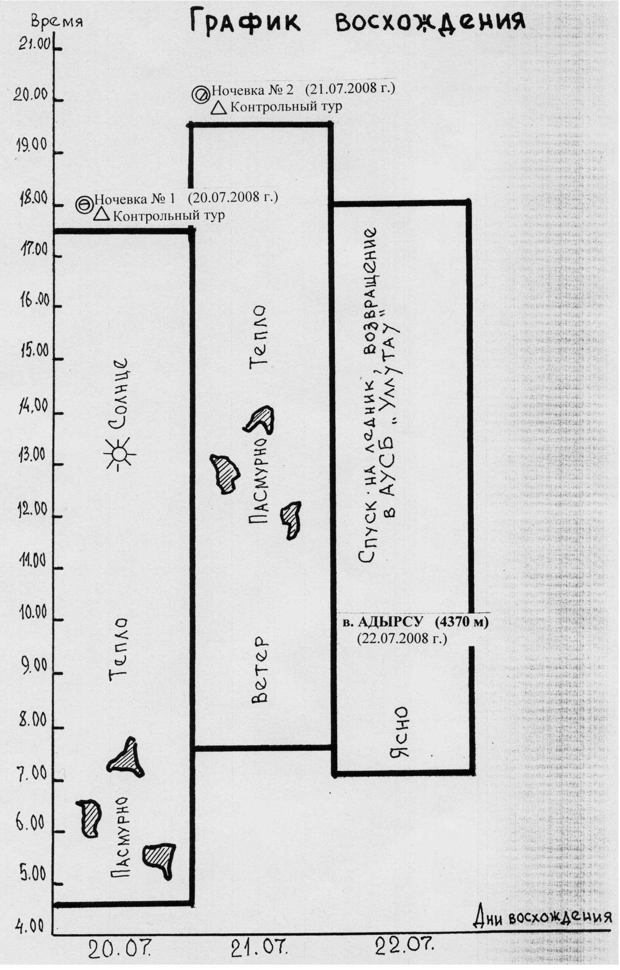
Ascent schedule

Team's tactical actions
July 19, 2008
At 10:00, the team departed from AUS "Ullutau" and arrived at the overnight location at "Ryжие камни" at 12:30, setting up a bivouac. On the same day, a reconnaissance of the approach path to the lower part of the central bastion was conducted, and possible route variations were visually inspected. The planned route passes through the center of the SW wall of the bastion, between two couloirs with running water.
July 20, 2008
At 4:30, the team departed from the bivouac and, after traversing the scree, reached a steep snow-ice slope at the start of the route at the lower part of the bastion, on a scree ledge, where they set up the 1st control tour to mark the beginning of the route. They linked up and began moving in a rope team: Bulocnikov — Sandin — Monayenkov. The first climber in the team moved:
- in rock shoes
- on a double 50 m rope
- with a lightened backpack
Straight up the wall for 40 m (45°, 4 category), then up and left for 30 m (55°, 5 category) — reaching a rock ledge. From it, an ascent via an internal corner for 35 m (65°, 5 category) to the next station. From the station, first right for 20 m (90°, 5+ category), then on friction left to a passage between a rock cornice and an overhang to a good ledge — station.
From it:
- straight up the wall for 50 m (65°, 5 category) to a small ledge
- another 50 m (55°, 5 category) — reaching a large platform 15 × 7 m with an overhanging upper part.
Under the overhang, a tent can be set up; there is little water.
Further:
- bypass the overhanging part from the left
- via an inclined slab for 50 m (90°, 5+ category) under the wall — complex climbing
- then 40 m (60°, 5 category) to a good ledge — station.
From the ledge:
- 20 m (55°, 5 category) straight up the wall
- complex climbing for 50 m (90°, 5+ category) — to the 2nd control tour and overnight location in a tent.
From the overnight location:
- a simple exit left for 30 m (35°, 2 category) to the top of the bastion
- then to a snow-ice slope.
At 17:30, they stopped for the night. From the "Ryжие камни" bivouac — 13 hours of work.
July 21, 2008
At 7:30, the team departed from the overnight location on the bastion. The further route passes via a steep snow-ice slope for 350 m (45–50°, 4 category), with insurance via ice axes and ice screws. Movement upwards is carried out along the left part of the glacier, along the rock ridge. In the upper third, the ascent via the glacier passes through two glacier crevices filled with snow. Insurance.
The route via the snow-ice slope approaches under wet, destroyed rocks with indistinct, inclined ledges. Further upwards via destroyed rocks for 50 m (55°, 5 category), station. From it, an exit to a steep snow-ice ridge and ascent via it for 50 m (45°, 4 category) to the base of a narrow couloir filled with snow and ice, which is crossed to the right for 20 m.
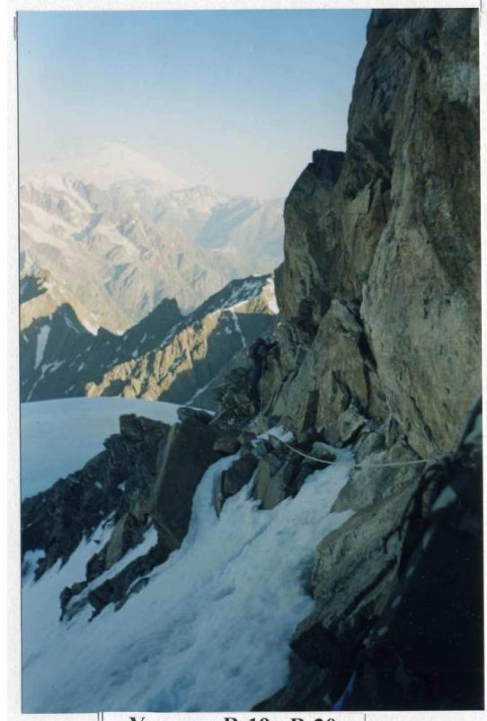
In the direction of an indistinctly expressed platform. From here, via a crack upwards for 45 m (60°, 5 category) — exit to a steep, smooth, vertical internal corner. Via it for 15 m (90°, 5+ category) — exit to the rocks of the ridge part of the route for 40 m (45°, 4+ category). Via the rocks of the ridge:
- approach to the snow-ice "knife"
- via it for 80 m (35–40°, 4 category)
- to a large square rock, which is bypassed from the left and then right under the overhanging rock of the Adyrsu summit ridge.
At this location, at 19:30, the group organized a sitting overnight on a laid-out narrow ledge. Here, the 3rd control tour is set up. From the overnight location on the bastion — 12 hours of work.
July 22, 2008
At 7:00, the team began moving. From the overnight location, left for 25 m via destroyed, snow-covered rocks — exit to the NW ridge. Via the snow ridge with steepness up to 35–40° (cornices) approach the pre-summit ascent. After crossing the bergschrund on the pre-summit ascent, exit to a simple short rock ridge and ascend to Adyrsu peak, where they arrived at 9:30.
Descent from the summit via the 3B category route along the NW ridge (D. Kokkin's route) to a rock saddle to a large gendarme. From the saddle, 20 m down to the right to the first rappel point. Further, five diagonal rappels to the right for 50 m each — descent to the glacier. Along the nameless glacier, following its right side, they descended to the bivouac at "Ryжие камни". The descent took 4 hours and 30 minutes. The team's return to AUS "Ullutau" was at 18:00.
Conclusions and recommendations for the ascent route
The route is relatively safe; there are few "live" stones, and spontaneous stone and ice falls were not observed.
There are locations for organizing a bivouac on the wall of the bastion on ledges, where a platform can be laid out. The platform on top of the bastion (at the time of passage) is relatively safe, as small stones that have thawed out on the glacier go to the right and left into the stream beds. For an overnight stay by two people, a niche 1 m × 2 m with an overhanging upper part in the wall of this platform can be recommended.
In the second part of the route (after the bastion), when passing the ice part, there are no convenient locations for an overnight stay. The location of the sitting overnight under the overhanging rock of the pre-summit ridge is recommended for organizing a bivouac by subsequent groups. If there is a late exit to the NW ridge and the need for an overnight stay, there is a possibility of organizing it 50 m below on the ridge in a mulde.
It is recommended to pass the route in the first half of the summer season. Additionally, it is necessary to consider the presence of groups ascending via the pre-summit NW ridge (3B) and SW ridge (3A), as falling stones can fly directly along the ascent path via the glacier. Possible stone thawing and falling along the glacier in the second half of the day makes the ascent problematic and dangerous. It is recommended to exit to the glacier no later than 6–7 am.
Description of the ascent route by sections
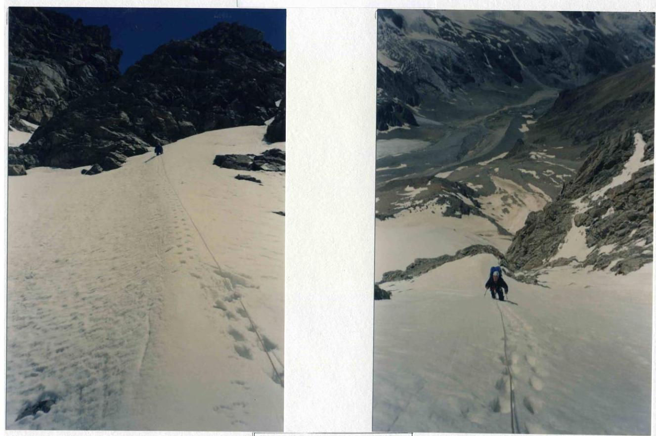
- R0–R1: 150 m, 35–40°, 2 category — from the moraine to the lower part of the bastion via a steep snow-ice slope to a ledge. 1st control tour.
- R1–R2: 40 m, 45°, 4 category — straight up the wall.
- R2–R3: 30 m, 55°, 5 category — up and left via rocks, exit to a ledge.
- R3–R4: 35 m, 65°, 5 category — from the ledge, ascend via an internal corner to the next station.
- R4–R5: 20 m, 90°, 5+ category — ascend up and right, then left — passage between a cornice and an overhang.
- R5–R6: 50 m, 65°, 5 category — via the wall to the next station.
- R6–R7: 50 m, 55°, 5 category — exit to a large ledge 15 × 17 m.
- R7–R8: 50 m, 90°, 5+ category — bypass the overhang from the left and via an inclined slab under the wall, complex climbing.
- R8–R9: 40 m, 60°, 5 category — ascend via the wall to a good ledge.
- R9–R10: 20 m, 55°, 5 category — from the ledge, ascend via the wall.
- R10–R11: 50 m, 90°, 5+ category — complex climbing to the overnight location. First overnight (July 20, 2008). 2nd control tour.
- R11–R12: 30 m, 35°, 2 category — from the overnight location, exit left to the top of the bastion to the snow-ice slope.
- R12–R13: 350 m, 45–50°, 4 category — via the snow-ice slope, approach under wet, destroyed rocks.
- R13–R14: 50 m, 55°, 5 category — via destroyed rocks to the snow-ice ridge.
- R14–R15: 50 m, 45°, 3 category — via the snow ridge to the start of a narrow couloir filled with snow and ice. Cross the couloir to the right for 20 m.
- R15–R16: 45 m, 60°, 5 category — via a crack, ascend to an internal corner.
- R16–R17: 15 m, 90°, 5+ category — via a steep internal corner, ascend to the rocks of the ridge part of the route.
- R17–R18: 40 m, 45–50°, 4 category — via the rock ridge, approach the snow-ice "knife".
- R18–R19: 80 m, 35–40°, 3 category — via the snow "knife" to a large square rock, bypass it from the left and right under the overhanging rock. Second overnight (July 21, 2008). 3rd control tour.
- R19–R20: 25 m, 3 category — from the overnight location, exit left via destroyed rocks to the NW ridge. Via the snow ridge 35–40° (cornices) approach the pre-summit ascent. After crossing the bergschrund, exit to a simple rock ridge and ascend to Adyrsu peak.
Descent from the summit via the 3B category route along the NW ridge (D. Kokkin's route).
Photo illustration of the report — 2
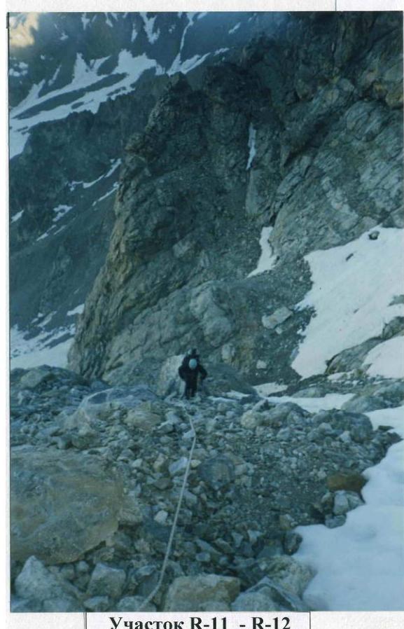
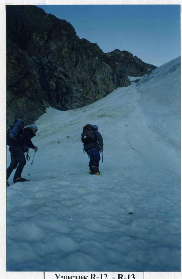
Photo illustration of the report — 3
Section R1–R2
Photo illustration of the report — 4
Section R3–R4

Section R5–R6
Photo illustration of the report — 5
Section R6–R7
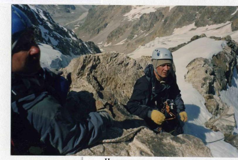
At the summit