Ascent Passport
- Ascent category — rock climbing
- Ascent area — Western Caucasus, Nakhara region
- Ascent route — Bolshoi Nakhara peak 3780 m via Northwest wall, 6B category
- Route characteristics
Height difference — 1000 m. Average steepness — 80°. Route length — 1565 m. Length of complex sections — 785 m. 5. Pitons hammered in
Rock pitons — 309. Bolt pitons — none. Chocks used — 26. 6. Total climbing hours — 48 h 30 min. 7. Total climbing days — 5 (including one rest day) 8. Number of overnight stays and their characteristics — 3 on platforms (1 lying down, 2 sitting)
- Team name — Physical Culture Collective of the VKhS combine, Uzunkol alpine camp
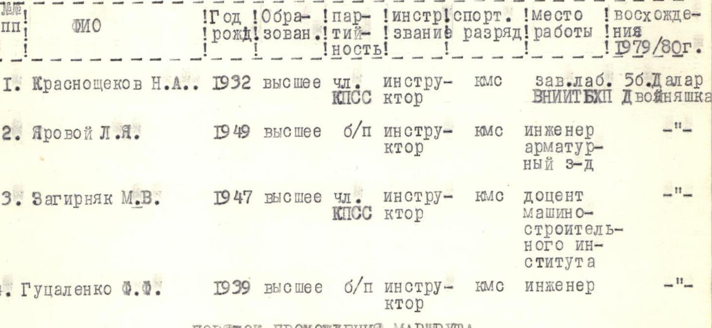
- Full name of team leader, participants, and their qualifications:
- Krasnoshchyokov N.A., Candidate Master of Sports, team leader
- Yarovoi L.Ya., Candidate Master of Sports
- Zagirnyak M.V., Candidate Master of Sports
- Gutsalenko F.F., Candidate Master of Sports
- Team coach — Zakharov Pavel Pavlovich
- Departure and return dates: July 26–30, 1980
1. Brief geographical description and sports characteristics of Bolshoi Nakhara peak
Bolshoi Nakhara peak — 3780 m is located in the mountain massif of the northern spur of the Main Caucasian Range between the Nakhara and Gondaray rivers. The massif is a grandiose twelve-kilometer rock ridge, resembling a castle with several towers, having three main peaks from south to north:
- Yuzhny Nakhara — 3582 m,
- Sredny Nakhara — 3646 m,
- Severny or Bolshoi Nakhara — 3780 m.
The entire area is part of the Karachay-Cherkess Autonomous Oblast of the Stavropol Krai, RSFSR.
The first ascents to the Nakhara peaks date back to 1904, when A. Fischer (Austria) with guide Kh. Iossi ascended Sredny Nakhara. In 1937, B. Sakhovich, V. Koryakin, and others first ascended Bolshoi Nakhara from the northeast.
Currently, the following routes have been established on Bolshoi Nakhara peak: Koralbin's route via the northeast wall, 6B category, 1974 — 1st place in the USSR championship Kovtun's route via the northwest wall, 5B category, 1977 — 3rd-4th place in the USSR championship Krasnoyarsk residents' route via the northwest wall, 5B category, 1978 — 2nd place in the USSR championship Route via the northeast ridge, 5A category, 1978 Route via the northeast crest, 3A category, 1973 Route via the northwest crest, 4A category, 1977 Route via the western crest, 2A category, 1976
2. Brief description of ascent conditions in the Nakhara gorge area
All peaks in the area are composed of strong, monolithic fine-grained granites, gneisses, and basalts. All northern sides of the peaks stand as sheer walls, transitioning into short, torn glaciers at the bottom.
The weather in the area is variable; during the period from July 23 to August 3, there were:
- rain,
- snow,
- sleet with fog, with clear days interspersed every 2–3 days.
From the Nakhara gorge, only the Bolshoi Nakhara peak is visible.
A small cirque, over which the wall looms, is squeezed on three sides by sheer walls of the peaks:
- Bolshoi Nakhara,
- Shedok-Minge,
- Asu-Minge,
- Dvuzubka, and on the fourth side, the foot of the wall and its middle part are obscured by the high moraine of a small glacier. The nearest settlement is the village of Uchkulan, located to the north, 40–50 km away.
3. Organization and tactical plan for the ascent
Having received necessary consultations from the pioneers of the northwest wall route on Bolshoi Nakhara, 6B category, we prepared the corresponding equipment, the necessary set of pitons, ladders, jumar clamps, high-calorie food, and clarified the route timing.
Before departing on the route, the team conducted joint ascents on 5B category routes to Dalar and Dvoinyashka peaks.
The ascent to Bolshoi Nakhara was planned from July 23 to August 5. July 24–25 were allocated for observing the route. The actual route passage was planned from July 26 to 31, 1980. July 26 was designated for processing the first bastion; an additional 140 m of rope were taken, which were to be thrown down after passing the 1st bastion.
In the tactical plan, the route is to be traversed by the first rope team: Zagirnyak–Yarovoi, and the second: Gutsalenko–Krasnoshchyokov. On the second day, the rope teams switch. The first goes on a double rope, subsequent complex steep sections are traversed using jumar clamps with top rope belay. A sufficient set of pitons, lightened backpacks, timely rotation of the first climbers, and good mutual understanding on the route will ensure successful passage.
Route
Via the northwest wall of Bolshoi Nakhara peak. 6B category.
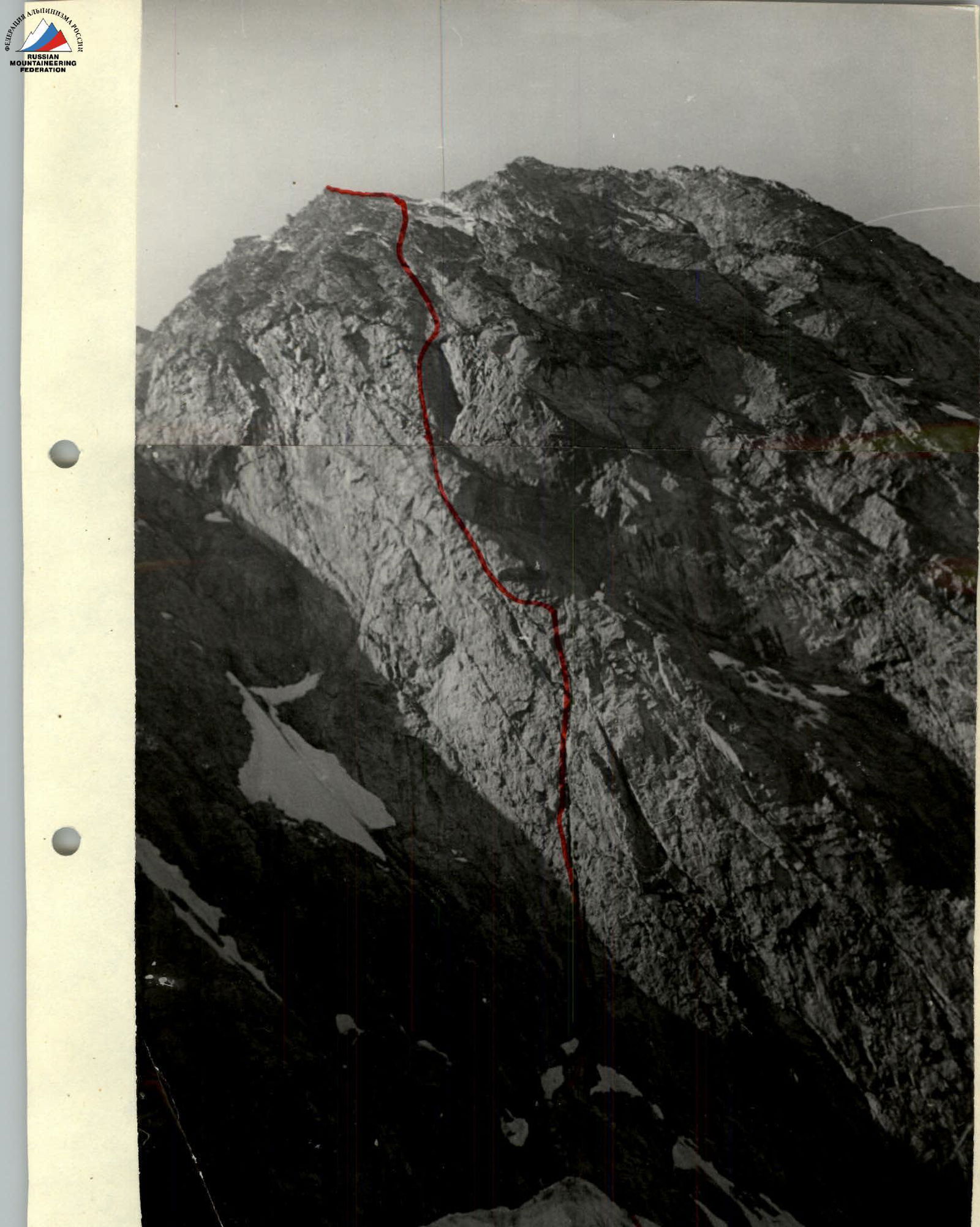
Northwest wall of Bolshoi Nakhara peak
Koralbin's route, 6B category.
Team composition
All four team members conducted regular joint training and completed one or two 5B category ascents in the current season.
Assault group composition
Route passage order
On July 23, 1980, the team departed from the Uzunkol alpine camp to the Nakhara gorge and approached the walls of Bolshoi Nakhara peak on the moraine via steep slopes. July 24–25 were spent observing the passage of the Uzunkol alpine camp team led by Tuitsin A. on the 6B category route to Bolshoi Nakhara peak via the northwest wall. On July 26, the processing of the 1st bastion began.
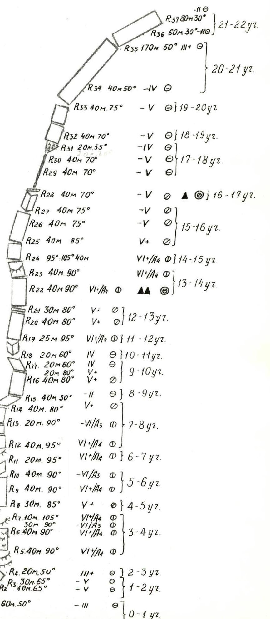
R0–R1. Snow slope, 50° steepness, 60 m length, traversed simultaneously.
R1–R2. Rock wall, 65°, 40 m, few cracks, difficult climbing, 6 rock pitons hammered in, 1 chock used. Traversed with free climbing.
R2–R3. Rock wall, 65° steepness, 30 m length, 5 rock pitons hammered in, 1 chock used. Traversed with free climbing.
R3–R4. Rock wall, 50° steepness, 20 m length. Traversed with free climbing. 4 pitons hammered in.
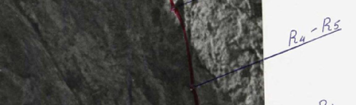


 R4–R5. Monolithic sheer wall with overhangs and cornices. Difficult climbing. 90° steepness, 40 m length. 13 pitons hammered in. Ladders and artificial holds used.
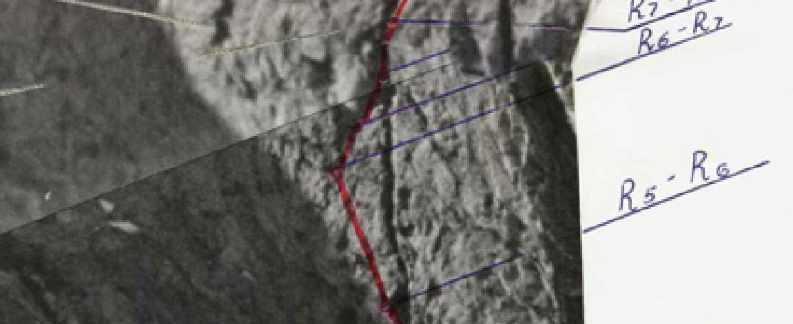
R5–R6. Section of iced-over rock, 90°, 40 m, few holds, few cracks. 12 pitons hammered in, ladders and artificial holds used.
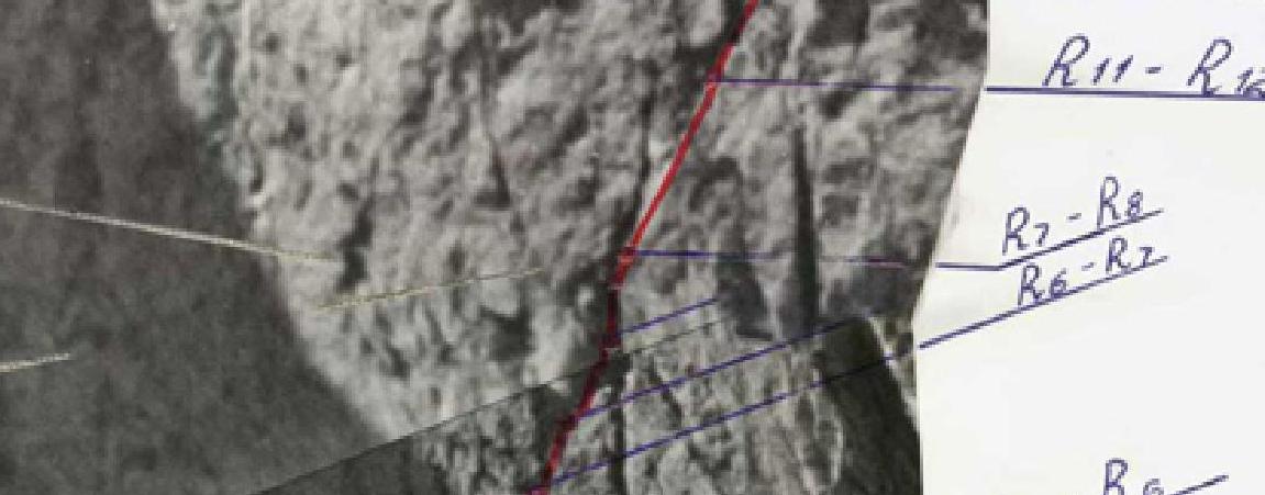
R6–R7. Monolithic wall, 90°, 30 m length, and another 10 m overhang, 105°. Ladders and artificial holds used. 20 pitons hammered in.
R7–R8. Traverse right along a slope, 85°, 30 m to a crevice. 6 pitons hammered in, 1 chock used. Traversed with free climbing. Bivouac site.
R8–R9. Sheer wall with water flows, 90° steepness, 40 m length. Ladders and artificial holds used. 20 pitons hammered in.
R9–R10. Sheer wall with water flows, 90°, 40 m. Difficult and tense climbing. 18 pitons hammered in.
R10–R11. Negative inner corner, 95°, 20 m length, with water flows. Ladders and artificial holds used. 14 pitons hammered in.
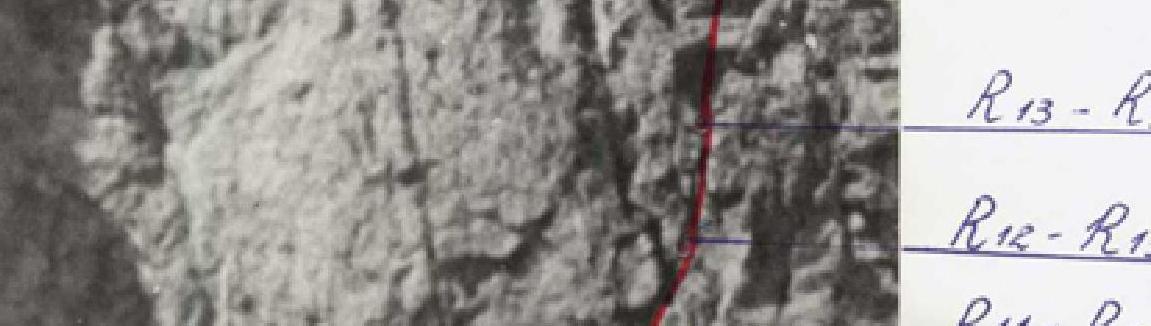
R11–R12. Monolithic smooth wall, 90° steepness, 40 m length. Water flows, holds are smoothed. Cornice, 105°, 3 m length. Few cracks. Artificial holds used. 22 pitons hammered in.
R12–R13. Monolithic smooth wall, 90° steepness, 20 m length. Few cracks, holds are smoothed, water flows. Ladders used. 11 pitons hammered in, 1 chock used.
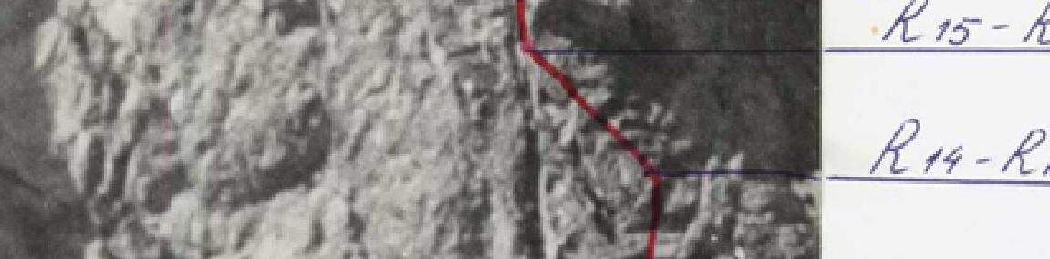
R13–R14. Smooth wet wall, holds are smoothed, 80° steepness, 40 m length, traversed with free climbing. 9 pitons hammered in, 3 chocks used.
R14–R15. Ledge, easy rocks, 30°, 40 m. Bivouac platform. Control cairn, 2 pitons hammered in. Rope team returned to the bivouac on the moraine.
R4–R5. Monolithic sheer wall with overhangs and cornices. Difficult climbing. 90° steepness, 40 m length. 13 pitons hammered in. Ladders and artificial holds used.
R5–R6. Section of iced-over rock, 90°, 40 m, few holds, few cracks. 12 pitons hammered in, ladders and artificial holds used.
R6–R7. Monolithic wall, 90°, 30 m length, and another 10 m overhang, 105°. Ladders and artificial holds used. 20 pitons hammered in.
R7–R8. Traverse right along a slope, 85°, 30 m to a crevice. 6 pitons hammered in, 1 chock used. Traversed with free climbing. Bivouac site.
R8–R9. Sheer wall with water flows, 90° steepness, 40 m length. Ladders and artificial holds used. 20 pitons hammered in.
R9–R10. Sheer wall with water flows, 90°, 40 m. Difficult and tense climbing. 18 pitons hammered in.
R10–R11. Negative inner corner, 95°, 20 m length, with water flows. Ladders and artificial holds used. 14 pitons hammered in.
R11–R12. Monolithic smooth wall, 90° steepness, 40 m length. Water flows, holds are smoothed. Cornice, 105°, 3 m length. Few cracks. Artificial holds used. 22 pitons hammered in.
R12–R13. Monolithic smooth wall, 90° steepness, 20 m length. Few cracks, holds are smoothed, water flows. Ladders used. 11 pitons hammered in, 1 chock used.
R13–R14. Smooth wet wall, holds are smoothed, 80° steepness, 40 m length, traversed with free climbing. 9 pitons hammered in, 3 chocks used.
R14–R15. Ledge, easy rocks, 30°, 40 m. Bivouac platform. Control cairn, 2 pitons hammered in. Rope team returned to the bivouac on the moraine.
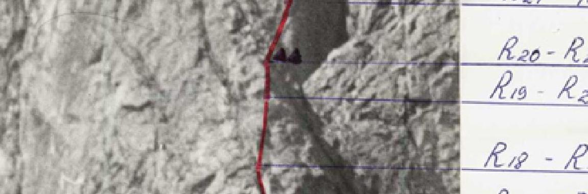
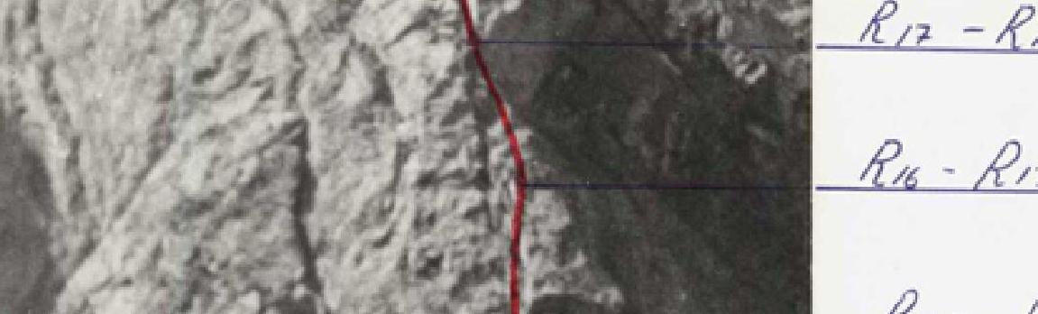
July 27 Traversed the processed part of the route and continued climbed further. R15–R16. Wall, 80° steepness, 40 m length. Wet rocks with tile-like structure, holds are smoothed. Traversed with free climbing. 8 pitons hammered in. R16–R17. Wet rocks with tile-like structure, 80°, 20 m, transitioning into a smooth, strongly inclined ledge to the left of the wall, 60°, 20 m. Traversed with free climbing. 7 pitons hammered in, 1 chock used. R17–R18. Continuation of the strongly inclined ledge to the left of the wall, 60°, 20 m, leading to a negative inner corner. Traversed with free climbing. 4 pitons hammered in. Rocks are wet, water flows. R18–R19. Not clearly defined inner corner — negative, few holds, ladders and artificial holds, 95°, 25 m, walls are smoothed, wet. 14 pitons hammered in, 1 chock used. Water flows. R19–R20. Monolithic smooth wall, 80° steepness, 40 m length. Holds are small, traversed with free climbing. 11 pitons hammered in, 2 chocks used. R20–R21. Monolithic smooth wall, 80° steepness, 30 m length. Traversed with free climbing. 7 pitons hammered in. Bivouac platform. Control cairn.
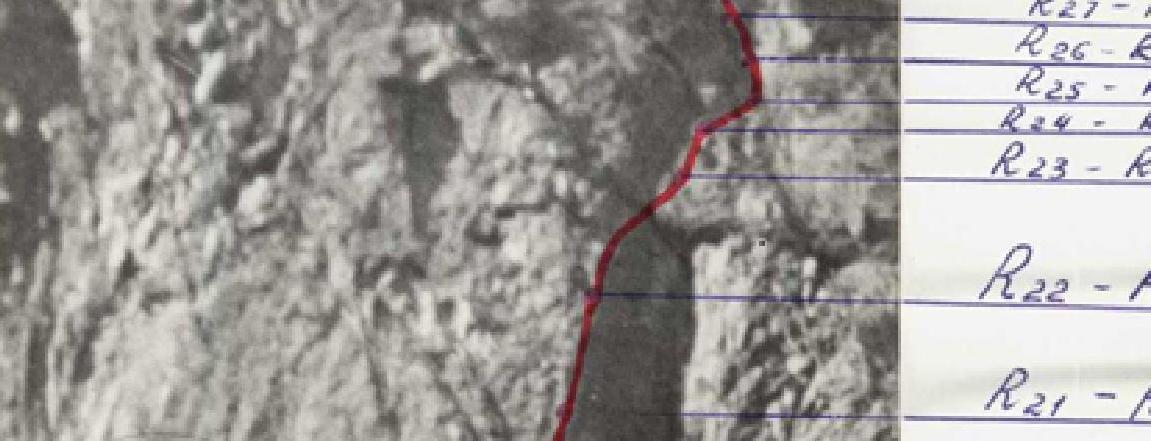
July 28 — bad weather, overnight stay on the platform. July 29 — continue traversing the route. R21–R22. Monolithic sheer wall, few holds, few cracks: 90° steepness, 40 m length. Very difficult climbing. Ladders and artificial holds used. 11 pitons hammered in. R22–R23. Monolithic smooth wall. Few holds, few cracks. 90° steepness, 40 m length. Ladders and artificial holds used. 9 pitons hammered in. R23–R24. Monolithic smooth wall, 90° steepness, transitioning into a cornice, 105°. Difficult and tense climbing, ladders and artificial holds used, 40 m length. 16 pitons hammered in. R24–R25. Rock wall, 85° steepness, many holds, diverse cracks, 40 m length. Traversed with free climbing. 8 pitons hammered in, 2 chocks used. R25–R26. Wall, 75° steepness, 40 m length. Many cracks, holds are small. Water flows. Tense free climbing. 7 pitons hammered in, 4 chocks used. R26–R27. Wall, 75° steepness, 40 m length, many cracks, holds are small, water flows. Traversed with free climbing. 6 pitons hammered in, 1 chock used. R27–R28. Inner corner, stream, exit to dry rocks. 70° steepness, 40 m length. Platform. Bivouac, overnight stay. 12 pitons hammered in.
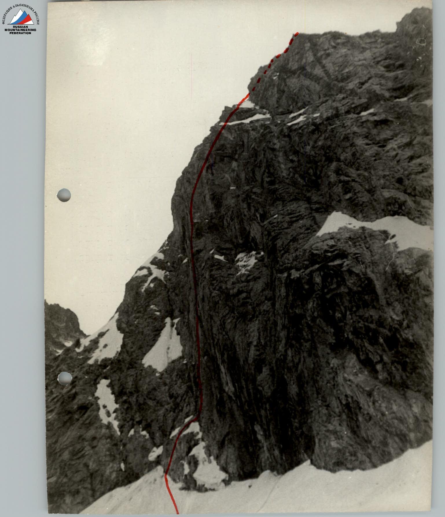
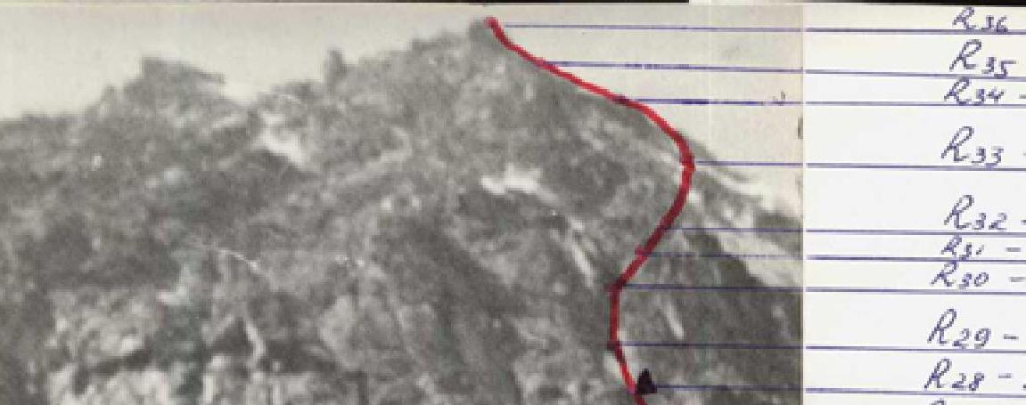
July 30, continue traversing the route. R28–R29. Dry rocks, 70° steepness, 40 m length. Traversed with free climbing. 6 pitons hammered in, 1 chock used. R29–R30. Dry rocks, 70° steepness, 40 m length. Traversed with free climbing. 4 pitons hammered in, 3 chocks used. R30–R31. Dry rocks, 70° steepness, 20 m length, good holds, traversed with free climbing. Crossing through a couloir with snow to the right, 55° steepness, 20 m length, 5 pitons hammered in. R31–R32. Slab-like rocks, 70° steepness, 40 m length. Traversed with free climbing. 4 pitons hammered in. R32–R33. Smoothed rocks, 75° steepness, 40 m length, many holds. Traversed with free climbing, 5 pitons hammered in, 1 chock used. R33–R34. Rocks are dry. Gradual incline, 40 m, 50°, traversed simultaneously. 1 piton hammered in. R34–R35. Rocks are dry, 50° steepness, 170 m length, traversed simultaneously. R35–R36. Rocks are dry, 30° steepness, 60 m length, traversed simultaneously, exit to a saddle before the peak. R36–R37. Ascent to the peak via easy rocks, 80 m, 30° steepness.
Overall assessment of team members' activities
Before undertaking this ascent, the team conducted preliminary work. Regular joint training in the rock quarry of Zuevka, Donetsk Oblast, positively influenced the ascent. Each team member knew the characteristics of all participants, so mutual understanding and interaction on the route were complete. The most complex sections of the route were traversed first by Zagirnyak M.V. and Yarovoi L.Ya. They oriented well on the route and correctly chose belay positions. The load of going first was distributed among the other team members. Felix Gutsalenko reliably traversed the middle part of the route. Lenya Yarovoi successfully traversed the difficult part of the second bastion.
Felix Gutsalenko performed a significant amount of work organizing the retrieval of backpacks.
Timely and delicious breakfasts and dinners were crucial for the successful ascent.
The ascent to Bolshoi Nakhara peak via the northwest wall was the result of the team's coordinated work.
Team captain N. Krasnoshchyokov
Data on auxiliary groups
The ascent organization is remote from alpine camps and settlements.
To reach the wall of Nakhara, transporting about 200 kg of cargo was required.
- Participants of the Severodonetsk gathering helped deliver the cargo to the base camp site.
Observers during the ascent maintained contact with the Uzunkol alpine camp via radios stationed at the "Globus" tourist base, coordinated movement, and photographed the wall.
Route characteristics
The route to Bolshoi Nakhara peak via the northwest wall, traversed by the group, is assessed by me as 6B category difficulty. It is technically complex, more challenging than Chatyn-Tau, reminiscent of the northern bastions of South Ushba, and the northern walls of Zamok peak.