Ascent Passport
- Ascent category — rock climbing.
- Ascent area — Uzunkol alpine camp.
- Ascent route with indication of peaks, their heights, route complexity (and other approximate data) — Bolshoy Nakhar peak (3780 m), complexity approximately 6th category of difficulty — via the right part of the northwest wall.
- Ascent characteristics:
- Route length — 1310 m.
- Height difference — 1000 m.
- Average steepness — 78°.
- Length of complex sections — 805 m.
- Pitons hammered: rock — 195, ice — 20 into rocks, wooden wedges — 23, placement elements — 6.
- Number of travel hours — 77 hours.
- Number of travel days — 8 days.
- Number of overnight stays and their characteristics: total 6 overnight stays, 4 on good platforms and 2 sitting.
- Team name: Combined team of CS DSO "Spartak".
- Full name of the team leader; participants and their qualifications:
- Team leader Kotov Eduard Vasilyevich — CMS.
- Participants:
- Prusakov Sergey Mikhailovich — MS USSR.
- Yanov Vitaly Fedorovich — MS USSR.
- Bazarov Vladimir Nikolaevich — MS USSR.
- Gudkov Vitaly Sergeevich — MS USSR.
- Team coach Yanov Vitaly Fedorovich — MS USSR, instructor.
- Date of departure and return: July 18–26, 1978.
ASCENT MAP TO BOLSHOY NAKHAR PEAK VIA THE RIGHT PART OF THE NW WALL
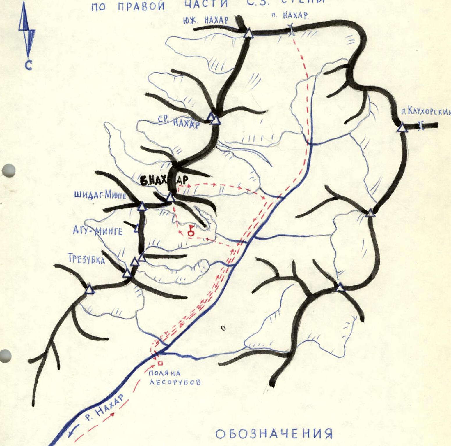
LEGEND
- LOGGING AREA
- TRAIL
- № OBSERVERS
- PATH OF THE SPARTAK CS CLIMBING TEAM
I. Brief Geographical Description and Sporting Characteristics of Bolshoy Nakhar Peak
Bolshoy Nakhar peak — 3780 m, is located in the mountain range of the northern spur of the Main Caucasian Range, between the Nakhar and Gondaray rivers. The massif is a grandiose twelve-kilometer rock ridge, resembling a castle with several towers, and has three main peaks from south to north:
- South Nakhar (3582 m).
- Middle Nakhar (3646 m).
- North or Bolshoy Nakhar (3780 m).
Nakhar translates from Svan as "bull". The peaks got their name from the pass of the same name, through which bulls were driven.
The entire area is part of the Karachay-Cherkess Autonomous Region of the Stavropol Krai, RSFSR.
The first ascents to Nakhar peak date back to 1904, when A. Fischer (Austria) with guide H. Iossi ascended to Middle Nakhar. In 1937, B. Sakovich, V. Koryakin, and others first ascended to Bolshoy Nakhar from the northeast.
In 1974, a group of climbers from the Uzunkol alpine camp led by B. Korablin made an ascent to Bolshoy Nakhar peak via the northwest wall, scoring in the USSR Climbing Championship. This route was classified as 6B category of difficulty and ranked 3rd in the championship.
In 1977, a group of climbers from the Dombay alpine camp led by V. Kovtun laid a path to the peak, classified as 5B category of difficulty.
II. Brief Description of Climbing Conditions in the Bolshoy Nakhar Gorge Area
The ascent route via the northwest wall to Bolshoy Nakhar peak had long remained out of sight for climbers. This is primarily because the wall is hidden from curious eyes: from the Nakhar gorge, only the peak of Bolshoy Nakhar is visible. Nature tried to hide it further, making it difficult to access. The nearest settlement is the village of Uchkulan to the north.
The area is generally characterized by good, stable, and consistent weather. All northern slopes of the peak stand as sheer walls, transitioning into short, rugged glaciers, huge drops, and steps descending into the gorge. The peak is composed of strong, monolithic fine-grained granites, gneisses, and basalt.
III. Organization and Tactical Plans for the Ascent
The ascent to Bolshoy Nakhar peak via the right part of the northwest wall, entered in the 1978 USSR Climbing Championship (rock climbing category), was organized by the Central Council of DSO "Spartak".
Before departing to the mountains, team members conducted joint training on the "Stolby" rocks. Immediately before the Championship, participants went through a training camp in the area of a/l "Talgar", where they made ascents of 6B category of difficulty to D. Talgar peak.
Before starting the route, a tactical plan was drawn up.
Table of Main Route Characteristics
Route steepness — 76°, including complex sections — 84°. Ascent route to Bolshoy Nakhar peak. Height difference — 1000 m, including the most complex sections — 680 m.
| Date |  | Characteristics of sections and conditions of their passage |  |  |  | Overnight conditions | |||
|---|---|---|---|---|---|---|---|---|---|
| By relief character By tech. difficulty | By method of overcoming and belaying | By weather conditions | Time | Pitons hammered | I5 | ||||
| I 2 | 3 | 4 | 5 | 6 | 7 | 8 | 9 10 11 | 12 13 14 | I5 |
| 18.07 R0–R1 | 80° | 40 | Wall with chimneys-cracks, monolithic | 5 | Complex climbing without backpacks | Good 8:00 5:00 | |||
| R1–R2 | 85–95° | 40 | Wall with crevices and cornices | 6 | Very complex climbing with artificial support points | — «» — | 18/5 2 into rocks | ||
| R2–R3 | 85–90° | 20 | Crevice with cornices | 5 | Complex climbing | 18:00 10:00 4 ч 00 мин | On moraine | ||
| 19.07 R3–R4 | 84–87° | 20 | Wall with small holds | 5 | — «» — | 11:00 3:00 1 ч 00 мин | |||
| R4–R5 | 110° | 25 | Wall with large cornice | 6 | On artificial support points | 17:00 6:00 | 23/6 3 into rocks 0/3 | On moraine |
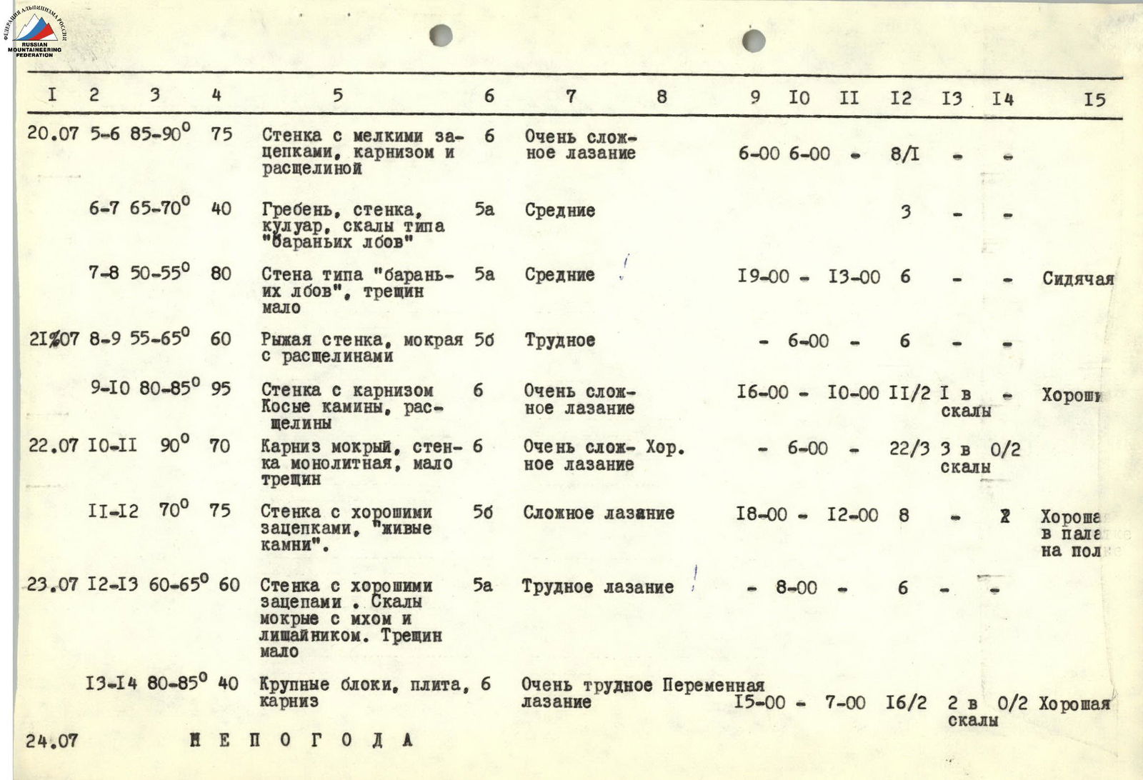
| 20.07 R5–R6 | 85–90° | 75 | Wall with small holds, cornice, and crevice | 6 | Very complex climbing | | 6:00 | 6:00 | 8 ч 00 мин | | | | | : ------------ | :------ | :-- | :--------------------------------------------------------------------------------------------------- | :------------------------------------- | :----------------------------------- | :---------------- | :--- | :---- | :--------- | :--- | :--------- | :------------------------ | | R6–R7 | 65–70° | 40 | Ridge, wall, couloir, rocks of type "ram's foreheads" | 5 | Average | | | | 3:00 | | | | | R7–R8 | 50–55° | 80 | Wall of type "ram's foreheads", few cracks | 5 | Average | | | 19:00 | 13:00 | 6 | | Sitting | | 21.07 R8–R9 | 55–65° | 60 | Red wall, wet with crevices | 5 | Difficult | | | 6:00 | | 6 | | | | R9–R10 | 80–85° | 95 | Wall with cornice. Oblique chimneys, crevices | 6 | Very complex climbing | | | 16:00 | 10:00 | 11/2 | 1 into rocks | Good | | 22.07 R10–R11 | 90° | 70 | Wet cornice, wall monolithic, few cracks | 6 | Very complex climbing | Good | | 6:00 | | 22/3 | 3 into rocks | | | R11–R12 | 70° | 75 | Wall with good holds, "live stones" | 5 | Complex climbing | | | 18:00 | 12:00 | 8 | 2 | Good in a tent on a shelf | | 23.07 R12–R13 | 60–65° | 60 | Wall with good holds. Rocks wet with moss and lichen. Few cracks | 5 | Difficult climbing | | | 8:00 | | 6 | | | | R13–R14 | 80–85° | 40 | Large blocks, slab, cornice | 6 | Very difficult variable climbing | | | 15:00 | 7:00 | 16/2 | 2 into rocks | Good | | 24.07 | | | | | BAD WEATHER | | | | | | | |
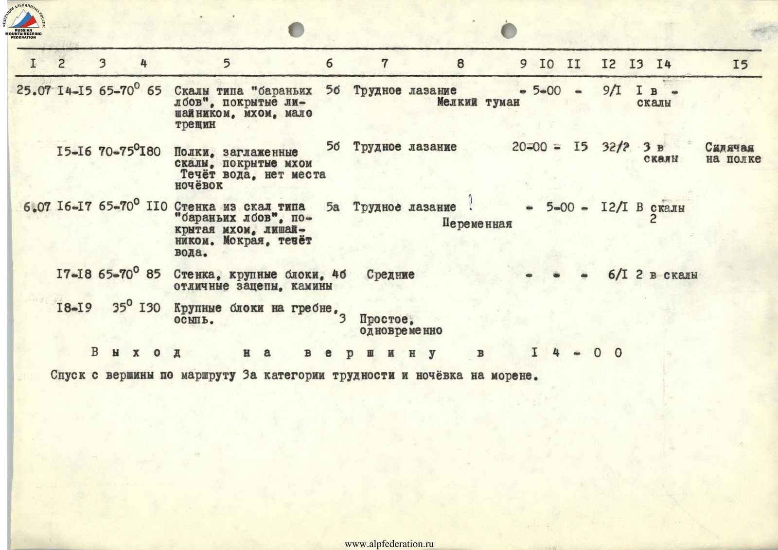
| 25.07 R14–R15 | 65–70° | 65 | Rocks of type "ram's foreheads", covered with lichen, moss, few cracks | 5 | Difficult climbing | Light fog | 5:00 | 9/1 | 1 into rocks | |||
|---|---|---|---|---|---|---|---|---|---|---|---|---|
| R15–R16 | 70–75° | 180 | Polka, smoothed rocks covered with moss. Water flowing, no overnight spots | 5 | Difficult climbing | 20:00 | 15:00 | 32/2 | 3 into rocks | Sitting on a shelf | ||
| 26.07 R16–R17 | 65–70° | 110 | Wall of rocks of type "ram's foreheads", covered with moss, lichen. Wet, water flowing. | 5 | Difficult climbing | Variable | 5:00 | 12/1 | 2 into rocks | |||
| R17–R18 | 65–70° | 85 | Wall, large blocks, excellent holds, chimneys | 4 | Average | 6/1 | 2 into rocks | |||||
| R18–R19 | 35° | 130 | Large blocks on the ridge, scree | 3 | Simple, simultaneous |
Reached the summit at 14:00.
Descent from the summit via the 3A category route and overnight stay on the moraine.
Route Passage Order
July 17, 1978. At 6:00, departure from a/l "Uzunkol" under Nakhar peak. Ascent to the moraine opposite the wall. The Prusakov—Kotov duo went under the wall to observe the route condition and choose the starting point. The rest are setting up a bivouac.
July 18, 1978. The Prusakov—Yanov duo departs for route processing. Departure at 8:00 am. After passing the initial section, they exit onto a wall with chimneys. The wall is monolithic, 40 m. 5 pitons hammered. Reception point for the second. Climbing is complex. The wall is 8 m slightly overhanging. Then 12 m to the left — exit to a 10 m cornice. Wooden wedges and ladders are used. Passage of an oblique cornice 5 m, throws to the left. Vertical crevice with small cornices 5 m. Exit to a fragment resembling a "comma". Very complex climbing with artificial support points. 25 pitons hammered, including 5 wooden wedges and 2 ice pitons into rocks. Along the crevice with cornices under "Paltsev" — another 20 m. Climbing is complex. No overnight stays. At 18:00, the duo descends from the route. A decision is made to continue processing the next day.
July 19, 1978. At 10:00, the Prusakov—Gudkov duo departs from the bivouac to continue route processing. Along the curved part of "Paltsev" 7 m, traverse to the left 5 m, along overhangs 8 m, exit to "Paltsev" under "Big Cornice" — a nail of the route in this part of the "bastion". Reception point. First control point. The cornice length is 15–16 m, and the overhang is 6 m. Processing it takes 6 hours. All types of pitons, ladders, platforms, and placement elements are used. 28 pitons hammered, 25 m passed in total. Water is flowing down the wall, creating a "shower". Working is impossible, and at 17:00, the duo descends, determining a possible overnight spot on "Paltsev" under the "Big Cornice". A decision is made to depart with the full team the next day.
July 20, 1978. Early rise. Packing, and the five of them depart under the route. Ascent via ropes to "Paltsev" and pulling up backpacks. The Yanov—Prusakov duo leads further route processing above the cornice. From a small platform, width of half a step and 0.5 m long, reception in ladders, along the wall to a sheer crevice 3 pitons, 12 m under the cornice, 2 pitons on the cornice. Movement left via a sheer wall to a ledge, from the ledge up the wall — 7 m. Climbing proceeds along a wall with small holds to a crevice. From a ladder, exit to a crevice, movement from left to right 35 m under a yellow fragment of triangular shape. Reception point, backpack pulling point.
From the fragment, exit right onto a ridge — 12 m. Traverse left along the ridge 20 m wall, crossing a couloir with flowing water, and exit to "Ram's Foreheads" — 8 m. From a platform onto a gray wet wall of type "Ram's Foreheads", steepness 50–55°, few cracks, straight up with a backpack. Climbing is average.
No overnight stays. The duo descends to the backpack reception point. Gudkov V.S. joins the duo. Backpack pulling begins.
By the time the rain starts, we fail to complete all the work, and so three of us spend the night on the upper platform, while two (Bazarov V.N. and Kotov E.V.) — on "Paltsev" under the big cornice. Everyone is equipped with down gear and food: sitting overnight.
Total 195 m passed for the day.
July 21, 1978. The morning starts with pulling up a backpack and exiting from under the cornice. On this day, Prusakov S.M. works first with Yanov V.F., processing the "red wall" with flowing water. Climbing is difficult, few cracks, only 6 pitons hammered. Reached under a three-tiered cornice. The cornice is passed with artificial support points. Further:
- 10 m up an oblique chimney,
- movement along internal corners and crevices from right to left,
- passage of a wet forehead under the "black" cornice.
Climbing is very difficult. 95 m passed. Double ropes натянуты. 14 pitons hammered. No overnight stays. From the top, a platform is spotted. The duo descends. Along shelves with snow islands from the three-tiered cornice, we move left (60 m) to find an overnight spot. A suitable spot is found. It consists of two platforms: for four and for two people. The overnight spot is very convenient. Protected from rocks. Ropes are натянуты. Backpacks are pulled up. On this day, we worked for 10 hours, were very tired, and settled in for the night at 16:00. After a sitting overnight, we can rest well. This is the 2nd control point.
July 22, 1978. At 6:00, the Kotov E.V.—Prusakov S.M. duo ascends via натянуты ropes under the "black" cornice. Water is pouring down the "black" cornice day and night. Passage of the cornice with ladders. Further movement from left to right along an oblique crack covered by a small cornice, also with flowing water. Wooden wedges, ladders, boxes, and channels are used. Very steep. Climbing is very complex — throws off. Exit to a platform 40 cm long, 10 cm wide — reception point. Then along a sheer wall with a series of yellow-orange hanging small cornices up 40 m. The wall is sheer. Climbing is very complex. All types of pitons are used: from "petals" to wooden wedges; ladders. We exit onto an inclined shelf — Prusakov's reception point. From here, the wall becomes less steep, the angle decreases to 70°. The wall is 75 m long; with good holds, there are "live stones". Climbing is complex. On these two sections (R10–R12), 36 pitons are hammered, 145 m passed. We reached the 2nd bastion. Here, a convenient overnight spot.
July 23, 1978. At 8:00, from the overnight spot, the Yanov V.F.—Bazarov V.N. duo; crossing a snowfield from left to right along a wall with good holds, rocks wet with moss, steepness 60–65° (60 m) exits under the base of the pre-summit wall, consisting of large blocks. Exit onto a 20-meter wall ending in a cornice. 5 m under the cornice from right to left and up a crack (3 m) — exit to the cornice. The weather worsened completely. 14:00. Snow started — visibility is limited. The duo descends to the tent. No improvement in weather until evening.
July 24, 1978. At 6:00, via ropes, the Bazarov V.N.—Gudkov V.S. duo made an attempt to process the further route. Only 20 m processed. Heavy snow started. Visibility — zero. At 9:00, processing had to be stopped. The whole day was spent sitting in the tent.
July 25, 1978. Departure on the route at 5:00. Fog. Light rain. Ascent via ropes. Pulling up backpacks. The Prusakov S.M.—Yanov V.F. duo leads. Along rocks of type "ram's foreheads", ascent 45 m. Then along shelves, smoothed rocks covered with water, traverse left 180 m. Climbing is difficult. Everything is wet and heavy. At 20:00, stopped on a small shelf. Can organize a sitting overnight. This is the most difficult day for us. Worked for 15 hours.
July 26, 1978. Variable cloudiness. Can determine the direction of movement to the ridge. At 5:00, Kotov E.V.—Prusakov S.M. depart. Further ascent goes along a wall (110 m) of type "ram's foreheads", covered with moss and lichen. Rocks are wet, water flowing. Steepness 65–70°. Steepness doesn't decrease, but the character of the rocks changes. Large blocks, excellent holds, crevices, and chimneys lead us to the ridge. Along the ridge 130 m, we exit to the summit. The sun is shining. Time is 14:00. We leave a note and descend via the 3A category route to the moraine.
Team Captain
 E. Kotov