Climbing Passport
- Rock climbing category.
- Region 2.3, Caucasus, from Nakhar pass to Chipperazau pass.
- Nakhar Bolshoy, 3784 m, point 90, V. Kovtun's route 1977 via the center of the NW wall, rock climbing route.
- 6B complexity category, second ascent.
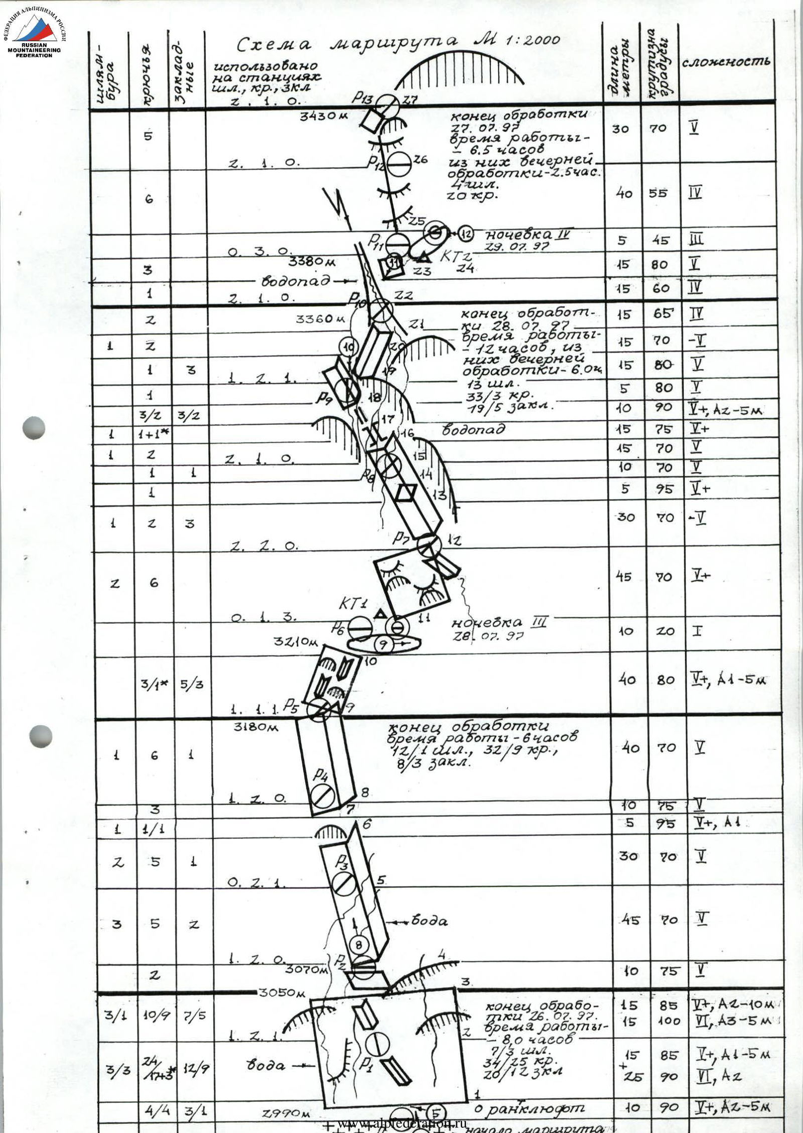
- Route characteristics: height difference – 800 m, wall height difference – 650 m (from 2990 m to 3640 m), average wall slope – 70°, route length – 1300 m, wall section length – 800 m, section lengths: 1 – 60 m, 2 – 150 m, 3 – 305 m, 4 – 110 m, 5 m, 5 – 620 m (including 25 m of artificial climbing), 6 – 55 m (including 50 m of artificial climbing), total artificial climbing – 75 m, with complexity: A1 – 15 m, A2 – 55 m, A3 – 5 m.
- Equipment used on the route:
- bolt hammers – 41/5, including 22 on stations
- rock pitons – 158/42 – 28
- chocks – 60/20 – 8
- previously left rock pitons – 6 (4 removed)
- left behind:
- rock pitons – 5
- chocks – 2
- bolt hammer holes – 41.
- Team's travel days – 5; hours – 42.5; including processing – 22.5, and evening processing – 8.5 hours.
- Night bivouacs: 1st and 2nd (2950 m) – lying in tents on the moraine under the wall in ABC after processing; 3rd (3210 m) – after the first bastion, lying, two on a "shelf" in bivouac bags, four in a tent on a prepared platform; 4th (3380 m) – after the second bastion, lying, five in a tent on a prepared platform.
- Team leader: Smotrov Sergey Ivanovich – CMS
Participants:
- Velikanov Vladimir Yuryevich – CMS
- Dorro Konstantin Eduardovich – CMS
- Leonov Petr Georgievich – CMS
- Nurbagandov Gadzhimurad Musaevich – CMS
- Shanavazov Shanavaz Eldarovich – CMS
- Coach: Murtazaliev Ziyavudin Murtazalievich
- Start of preliminary processing – July 26, 1997. Departure on the route – July 28, 1997. Summit – July 30, 1997. Return to base camp – July 31, 1997.
- Organization: Dagestan Republican Search and Rescue Service of the Ministry of Emergency Situations of Russia.
1997 Makhachkala
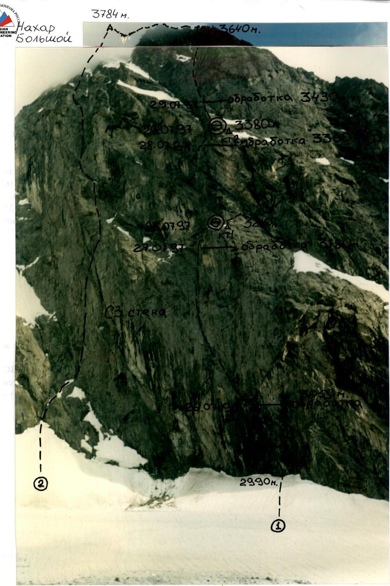
Photo 1. General view of the summit of Big Nakhar from the moraine under Dvuzubka peak, at an altitude of 2950 m.
- Team's route: via the center of the NW wall, 6B category, V. Kovtun, 1977.
- Route via the NW wall, 6A category, B. Korablin, 1974.
Photo taken on July 25, 1997, 17:00, "Smena-Simvol". The team does not have route threads: E. Kotov, 1978, Yu. Dzhaparidze, 1982.

Photo 2. Profile of the NW wall of Big Nakhar on the right. Team's route. July 31, 1997, 10:00. "Smena-Simvol".

Note: The ridge part of the route is shown conditionally.
Climbing Area Map
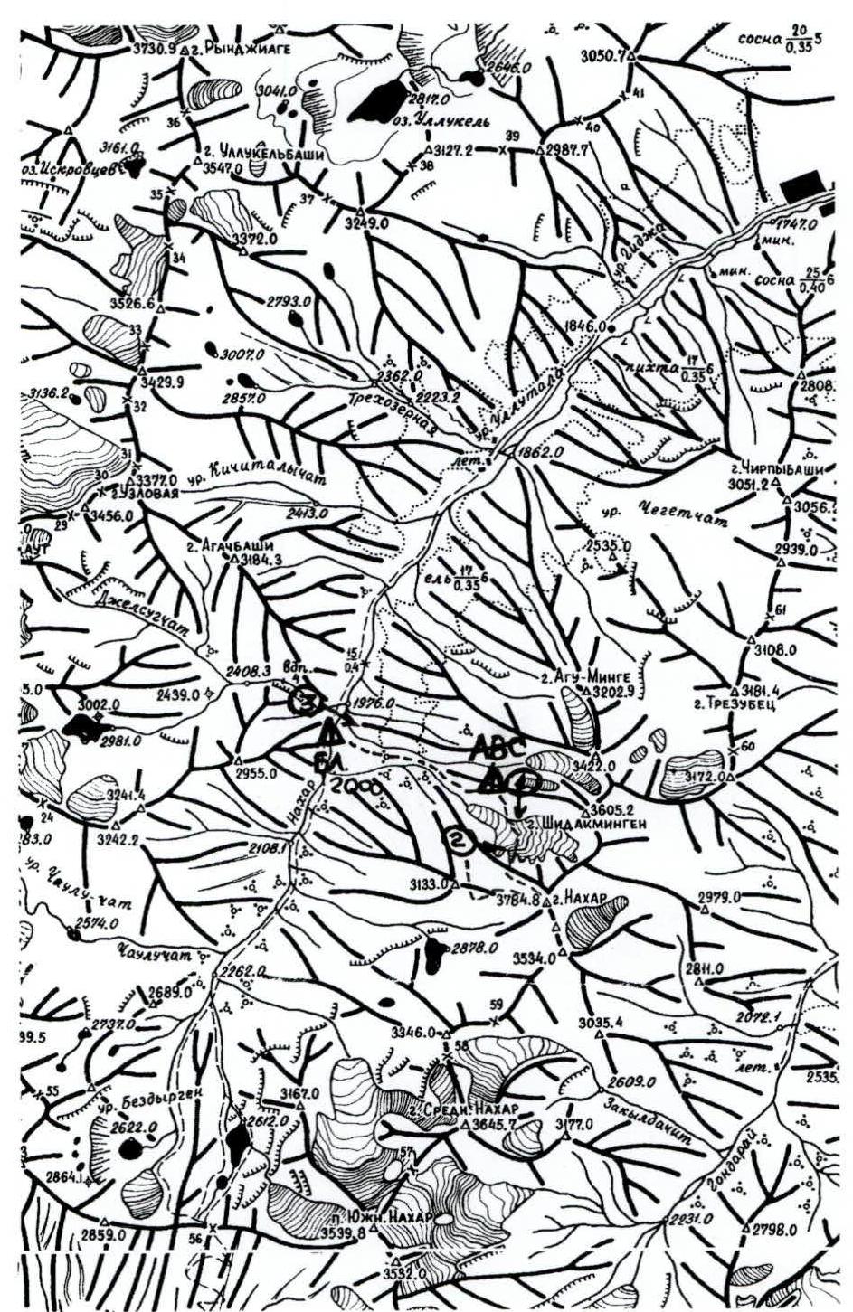
Scheme: V. Lyapin, 1989, Moscow. Scale 1:68 000
Team's Tactical Actions
When preparing for Big Nakhar, the team had only the thread of V. Kovtun's 1977 route and the locations of the bivouacs. The length of the sections and the height differences of the bastions were not known to us; neither was the tactics of the Kovtun group, the complexity of individual sections, or the convenience of the bivouac locations.
The route passes through the center of the NW wall through three bastions. Convenient places for bivouacs were visible between the bastions. The first bastion is the most complex, the second is simpler, and the third is less complex. The group decided that it was advisable to carry out preliminary processing of the route, considering the high complexity and steepness of the first ropes, as well as the easy and quick approach under the wall and the convenient forward base camp (PBL-ABC). For example, the Kovtun group camped 1.5–2 ropes from the glacier, under the second cornice, in a place irrigated by water. We considered this unacceptable with today's advanced technique of climbing on fixed ropes.
July 26
- The entire group left ABC at 9:00 and approached the wall.
- It turned out that the glacier is separated from the wall by a large randkluft, difficult to cross in this place (this is due to the water flowing down the wall and from the cornices).
- Width – 3 m, depth – 30 m (randkluft crossing on fixed ropes. Photo 5).
- The wall below the randkluft level is covered with rime ice.
- It was decided that the Dorro–Shanavazov team would work, while Leonov would stay on the glacier and coordinate the movement. The others left their equipment and returned to ABC.
- Dorro descended into the randkluft on a rope at 11:00, swung, pushed off the ice, and began working on the rock; the relief was complex, working immediately on artificial climbing.
- In some places, it was possible to climb in opposition, but it was very wet, with water flowing everywhere and algae (slime) on the rocks (Photo 6).
- At 12:30, Dorro had climbed about 20 m (including the randkluft), and then there was a fall (chock failure), flying about 8 m, and Dorro hung on a piton.
- There were no injuries, only minor bruises and scraped skin on the hand.
- During the first two ropes, the use of chocks was sometimes impossible, although there were gaps, but the rock structure was tile-like, with reverse slopes, cracks facing down, and in addition – wet rocks.
- Then there was another chock failure, but Dorro hung on a nearby piton.
- On the route, hard thin rock pitons (30 KhGSA) worked well.
- By 18:30, Dorro reached the second cornice, but it was already getting cold, he was completely wet, and his muscles began to cramp.
- The Dorro–Shanavazov team descended to the glacier by 19:00, having worked 60 m.
- By 19:30, the team returned to ABC.
July 27
- At 8:00, Smotrov, Velikanov, and Nurbagandov left ABC.
- At 10:00, the Nurbagandov–Velikanov team began working on fixed ropes (Photo 7) and by 11:00, Nurbagandov, having passed the previously processed section, began working first.
- In 1.5 hours, Nurbagandov processed the second rope (working mainly on artificial climbing and pitons), passed the second cornice.
- Smotrov was on the glacier with optics, coordinating the team's work via UHF radio.
- After the cornice, the relief became more gentle, but still complicated by wet rocks and slime on the slabs.
- By 15:00, 3.5 more ropes were processed (a total of 5 ropes were fixed).
- By 16:00, the team descended to the glacier and returned to ABC by 17:30.
July 28
- At 6:30, the entire group left ABC, and at 8:00, the Dorro–Shanavazov team began working on fixed ropes, having an additional static rope for fixed ropes and a dynamic rope for belaying (11 mm, Beal (Spain, UIAA)).
- Thus, the group took 6 ropes for fixed ropes – static and one for belaying – dynamic, UIAA (fixed rope climbing. Photo 8).
- By 11:00, the Dorro–Shanavazov team passed the fixed ropes and began working on the route.
- When passing the 6th rope of the route, Dorro encountered a ladder and rappel rings, likely left by the first ascensionists.
- At 12:30, Dorro reached a ledge – the bivouac site. He began clearing the platform; it was visible that another group had camped here.
- Velikanov worked last, belayed by Smotrov.
- As the ropes were freed, all participants received top rope belay while climbing on fixed ropes.
- By 14:00, the group gathered at the bivouac site.
- The Dorro–Nurbagandov team went up for further processing.
- After passing two ropes by 16:00, Shanavazov joined them on fixed ropes, brought equipment and two more fixed ropes.
- Shanavazov descended to the bivouac site, where the platform was being prepared for the night, and dinner was being prepared.
- Dorro began passing two ropes that went through a waterfall.
- The waterfall on the third rope had several streams (Station R9 was irrigated by water. Photo 10), and further on the 4th rope, it had one powerful stream.
- By 19:30, Dorro passed the 4th rope and began descending to the bivouac site.
- On the 4th rope (processing), there was a risk of being hit by stones and pieces of ice, as the route passed through a gully with a waterfall.
- By 20:00, the Dorro–Nurbagandov team descended to the bivouac site.
- The team was completely wet and had to undress to dry (Photo 9).
- The bivouac site was convenient but at risk of being hit by stones, and there was a possibility of stones hitting the platform.
- Velikanov and Smotrov slept on two platforms under awnings, while the others slept in a tent lying down.
- Water was flowing nearby – a stream.
- The night was warm, with a thunderstorm approaching, and lightning flashes.
July 29
- The morning was warm and foggy.
- They began working on fixed ropes at 8:00.
- At 9:00, it started raining, which turned into a downpour with hail by 10:00.
- At 11:00, the Nurbagandov–Velikanov team passed the fixed ropes and began working further.
- At 12:00, they passed a rope and reached the platform.
- Nurbagandov began working above the ledge but was forced to return due to heavy rain and hail, wet mossy slabs, and the risk of falling.
- Having climbed about 20 m, Nurbagandov returned to the ledge, leaving the ropes hanging.
- The group's presence in the gully became very dangerous – pieces of ice and stones cut the Beal rope (Spain, UIAA).
- Shanavazov left station R10 under continuous stonefall and climbed up through a powerful water flow (Photo 11).
- At 13:00, the group gathered on the ledge and set up a tent; the rain continued until 16:00.
- Everyone got completely wet (Photo 12).
- Only after the downpour ended at 17:00, the Nurbagandov–Velikanov team began processing.
- By 19:00, they finished processing two ropes, and at 19:30, the team descended to the bivouac site.
- At the bivouac site, they found notes from groups: V. Kovtun +5 dated August 4, 1977, first ascent via the center of Big Nakhar's wall, a/l "Dombay"; A. Khafizov +3 dated July 30, 1980, on Big Nakhar via 5B category route – Prusakov's route (?), a/l "Uzunkol".
- The platform was prepared in advance, relatively safe, with only a few instances of stones hitting from the left gully (during the downpour).
- The night was warm; the group slept in a tent on a convenient platform, with snow and a stream nearby.
July 30
- They began working on fixed ropes at 8:00.
- At 9:30, the Nurbagandov–Velikanov team began working further after the fixed ropes.
- At 17:00, after passing 8 ropes (from the bivouac site) (Photo 13), the group reached the ridge (the wall ended).
- Moving left into a cirque, the group left their gear and continued ascending via the 3rd ridge.
- At 18:00, the group reached the summit (Photo 14) (found a note from our own gathering – V. Sogokon +2, route 4A via the NW ridge, dated August 26, 1997).
- At 18:30, they began descending to the west:
- passed a gendarme,
- descended to their gear,
- then followed the "cairns" down.
- They reached the bivouac site on the saddle in the 3rd ridge by 20:30.
- Expanded the platform.
- Spent the night comfortably.
July 31
- Began descending to the NW at 8:00.
- By 10:00, the group traversed under Big Nakhar's walls and reached the right moraine of the glacier to the ABC site.
- Began descending to BL, arriving at 12:00.
The tactical plan for the ascent was largely fulfilled as planned: the ascent was completed with two bivouacs on the wall, after two days of processing. However:
- The group lacked information about the route.
- Could not assess the complexity of the first ropes.
- On the first day of processing, they did not complete 3 ropes as planned but only 1.5.
- On the second day of processing, they fixed a total of 5 ropes, not 6 as planned.
- After reaching the second bivouac site, during bad weather, the group processed only 2 ropes, not 5 as planned.
As a result, the group was unable to descend to the ABC site on July 30 and spent the night on the saddle in the 3rd ridge of Big Nakhar.
On the route, rock pitons and chocks ("stoppers", "hexes", "rocks", "friends") were used extensively, but their use was sometimes limited by the wall's structure. In some sections, bolt hammers (screw-in, 8 mm) were necessary for safety, especially on stations and on sections of the wall irrigated by water, and during bad weather. The team climbed the route with a reserve of physical and mental strength. The group tried to climb as much as possible using free climbing, but in some sections, artificial climbing was used, carried out with the help of regular ladders and hook footholds. The group had to wait out bad weather for about 5 hours in a tent at the second bivouac site. Communication with observers in ABC was timely. The observers included:
| Aliyev Sh.R. | CMS |
|---|---|
| Sogokon V.A. | CMS |
| Krasnopolsky Yu.V. | CMS |
| Skornyakov A.N. | CMS |
They also formed the rescue team. A support group of four 1st-class climbers was stationed in BL. BL had a ZIL-131 vehicle with a HF radio station, with communication coverage across the North Caucasus and Makhachkala three times a day. Between the group, observers, and BL, communication was carried out using UHF radios "Standard" (Japan) three times a day.
During the training camp in the Uzunkol area (July 10–22, 1997), the team completed an ascent of Dallar peak via the NE wall, 5B category (Yu. Prokhnia, 1978), and before that, a 3rd category ascent to the peaks of the Dolomit massif.
The weather conditions during the ascents in the Uzunkol area were challenging, allowing the team to adapt to the region's specifics. This helped during the passage of the Kovtun route, which is characterized by significant waterlogging. When faced with challenging weather conditions, the group was able to continue moving along the route and processing sections.
The route was unexplored, with our team making the second ascent, and 20 years had passed since the first ascent. The group believes this is due to the remoteness and inaccessibility of the area. Only with the availability of a high-cross-country army-version ZIL-131 vehicle were they able to reach BL from Uchkulan via a poor road and numerous fords, crossing the full-flowing Nakhar in 10 hours. On foot with such a load, the approach could have taken 3 days. The team worked in the area completely autonomously, with the ability to use their transport to deliver an injured person to a medical facility in case of an emergency. There was also a preliminary agreement with the Prielbrusye PSS of the Ministry of Emergency Situations of the Russian Federation (head of the service B. Tilov) about possible helicopter support in case of an emergency. The ZIL-131 vehicle carried a rescue kit from the Ministry of Emergency Situations – a first-aid kit, blood transfusion systems, droppers, "Paramedic" stretcher, vacuum splints for various body parts. There was also rescue equipment: winches and 500 m of cable (6 mm), a winch for a rope ("Petzl").
The rescue team, who were also observers, had sufficient qualification to perform their functions; all four had experience on 6B category routes, were in good physical shape, had undergone a cycle of training sessions and ascents, and before leaving for the mountains, had passed physical and technical training tests with "good" and "excellent" marks, as had the entire team.
Overall, the team climbed the route with minimal information about the area, transportation routes, and their condition, and the approach under the wall. During the ascent, several decisions were made to change tactics due to changing weather and climbing conditions. Decisions were made based on safety considerations.
The group tried not to leave pitons and chocks on the wall, and what was left behind was necessary for the last person to descend on numerous diagonal fixed ropes and pendulum sections. The group maintained cleanliness at the bivouacs and on the wall; trash and cans were buried in a pit in ABC, and items from the wall were flattened and carried down to BL.
The speed of climbing the wall section averaged 19.3 m/h, and after deducting descents from processing, climbing on fixed ropes, and downtime not related to work, the net time spent by the team on the wall was 26.3 m/h.
The team's participation in the Russian Climbing Championship was publicized in the press and on Dagestan television even before the team left for the mountains. This helped raise interest among Dagestan residents in climbing and the Championship. A major broadcast is being prepared on Dagestan television (at the end of September). Several articles and notes have already been published in the press about the team's trip to Karachay-Cherkessia. Now, we are waiting for the Championship results. The coverage includes photo and video materials from the route; the group has video materials from the processing and the team's life in BL and ABC, as well as during the descent and on the way.
| 5 | 3430 m | ||||||||
| 6 | |||||||||
| 2 | |||||||||
| 3 | 1. 2. 1. | ||||||||
| 3/2 | |||||||||
| 1 | 1 | ||||||||
| 3 | 2 |
Scale 1:1500 S → E 10
Route Description
The ascent route to Big Nakhar passes through the center of the NW wall via three bastions, with lengths of 6, 5, and 8 ropes, respectively (the group used safety and fixed ropes, each 50 m long). The route is logical, although not very straight. Once work began on this route, deviations and detours were illogical, complex, long, and even dangerous; one directly follows the path of the first ascensionists.
The wall is illuminated in late July:
- in the morning – from 8:00 to 11:00,
- in the evening – from 18:00 to 20:00.
The lower two ropes are illuminated in the morning and evening for an hour.
The route begins 20 m to the right of a curved oblique cornice at the bottom of the wall. In this place, the randkluft is particularly large due to the water flowing from above: width – 3 m, depth – 30 m.
After descending into the randkluft (Photo 5), you need to push off and grab an outcropping, and climb up a complex, wet, icy relief, partly on artificial climbing in opposition, to reach the level of the firn (Photo 6).
Next, two ropes of very complex relief go left-upward at an angle of about 30° from the vertical (section R1–R4) (Photo 6, 7). The relief features unclearly defined corners and gaps, everything is irrigated with water, streams flow, and there is slime (algae) and moss on the rocks, with overhangs on the left and right.
You need to cross two cornices:
- the first has an overhang of 0.5 m,
- the second – 1.5 m.
The second is passed at a large angle to the vertical, with very uncomfortable diagonal fixed ropes (you need to give more slack). Climbing is very complex, with a lot of work on artificial climbing. The relief is tile-like, with diagonal slopes, cracks opening downward. Chocks do not go in very well.
After passing the cornice, the relief becomes more gentle, but climbing remains tense. There is a system of long internal corners, climbing along the left side, with the right side sometimes overhanging (section R4–R9). Water seeps and streams flow everywhere (Photo 10). The general direction is left-upward.
From R5, move right-upward along large-block rocks, a system of internal corners, sometimes rockfall-prone, with unstable blocks.
Reach the summit of the first bastion. There are convenient platforms for two tents. From the bivouac site, move right-upward along uncomfortable tile-like rocks (section R11–R12) (the first 10 m are traversed), enter an oblique internal corner. From R7, along the left side of the corner (the right side overhangs) (section R12–R16), approach a waterfall that falls directly onto the corner; follow under the streams for about 10 m, but water drips and seeps everywhere. The right side of the corner increasingly overhangs the wall and turns into a chimney (section R16–R17), then narrows into a crevice (section R17–R18). In the crevice, there is an unstable block; artificial climbing is necessary to exit onto the wall. Then, along the corner, approach R9. Movement along sections R12–R13 is generally at an angle of 30° to the vertical, but the wall itself is steep.
From R9 (Photo 10) (an uncomfortable station, irrigated by water), move right-upward through a system of crevices and corners to enter a gully with a waterfall (Photo 11) (section R21–R23). It is advisable to exit this gully to the right, as it is dangerous (hit by stones and ice!). Along the right wall of the gully (section R23–R24), exit onto a shoulder to the right. Here, the second bastion ends (Photo 12). There is a ledge and a platform for a tent. To the right, there is snow and water.
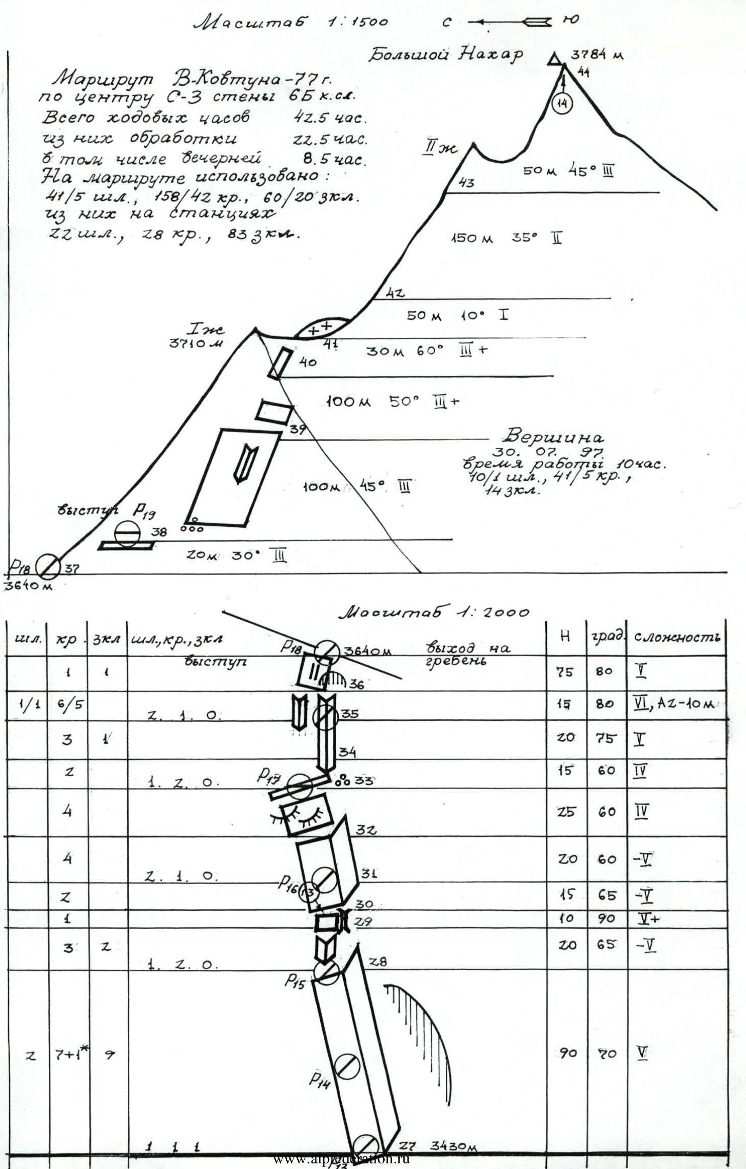
From the bivouac site upward (section R25–R27), follow a rocky ridge (not steep, with moss on the rocks, wet, slabs), exiting left – a small cornice, approach a large cornice, with station R13 to the left of it. Here begins a long internal corner (section R27–R32), complicated by flowing water, wet rocks, and moss. In the upper part, there is a steep wall (Photo 13).
Then, along slabs and tile-like rocks (section R32–R34), approach the next internal corner (do not deviate left or right). Climb the corner upward; it is blocked by an overhang, then deviate left and use artificial climbing, following an unclear relief corner and crevice, to exit onto the NW ridge of Big Nakhar (section R34–R37). Along it, move left (section R37–R38) into a rocky- talus cirque between the NW and 3rd ridges of Big Nakhar.
Then, along not steep rocks and a ridge, exit onto a gendarme (here the ridges connect) (section R38–R40). Traverse the gendarme to the right along slabs and descend onto a saddle (section R40–42). There is a platform. Then, along large talus and destroyed rocks through a small gendarme, ascend to the summit (Photo 14).
Descent follows the ascent route to the cirque (point R38) and then westward along simple rocks ("ram's foreheads", with stones). Move down following the cairns, keeping to the 3rd ridge, and avoid going right towards the stream and snowfields. After descending 300 m (about 3600 m), traverse left onto the 3rd ridge for about 100 m. Then, continue down the right side of the 3rd ridge (left wall) to an altitude of 3450 m. Here, in the ridge, there is a vaguely defined saddle (easy to miss, and further down, the cirque drops off on three walls):
- From it, rappel 30 m (down a corner into a gully, towards the lake).
- Down the gully (steep, with stones!) to the right, through a blockage – a boulder, exit to a drop-off.
- From it, rappel 20 m into the continuation of the gully.
- Then, down the gully, exit onto a rocky-talus slope and follow it right-downward for about 400 m to a saddle in the 3rd ridge (do not go left). On the saddle, there is a platform.
From the summit – 3 hours. From the saddle, traverse the ridge onto the talus cone of point 3133, then right (northward) and further right downward onto the snow in the gully (stones in the morning!). Follow the snowfield to its end (height difference about 200 m). From the snowfield, rappel down the moraine and talus slightly right-downward, and traverse a rocky bastion of the NW ridge. Then, moving northward with a gain in height, bypass a rocky remnant, exit onto the glacier, and follow it to the right-bank moraine (below ABC); from the saddle – 1.5–2 hours.
Further descent follows the ascent route to BL – 1.5–2 hours.
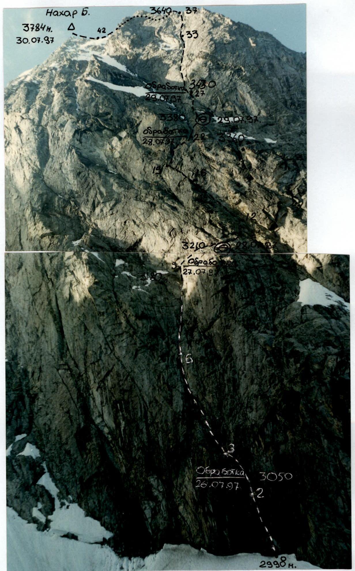
Photo 4. Technical photograph of the route from the moraine under Dvuzubka peak, at an altitude of 2850 m. July 26, 1997, 9:00, "Zenit-E".
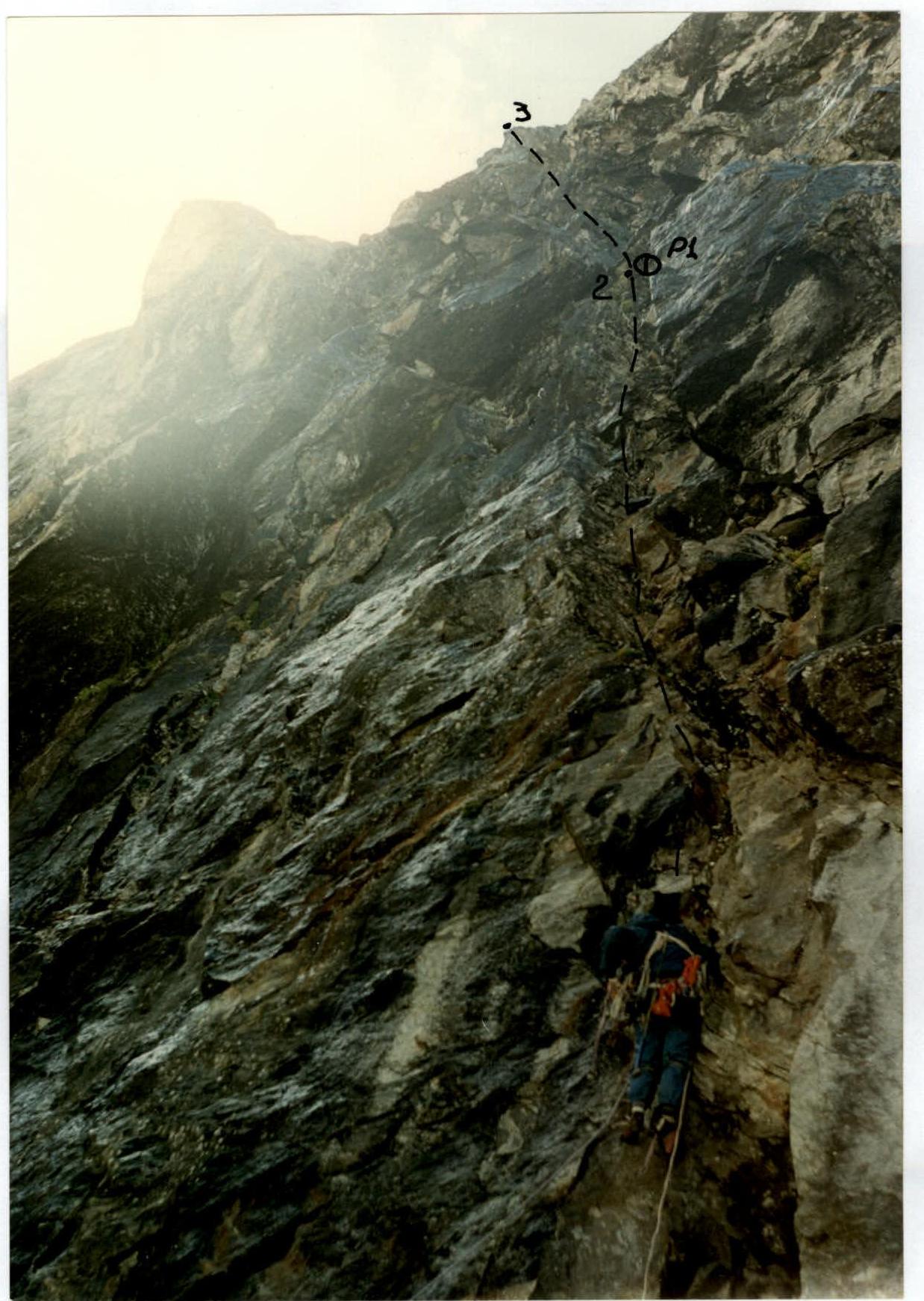
Photo 6. Dorro leads (section R1–R2) at the beginning of the route; taken from the edge of the bergschrund. Processing. First rope. July 26, 1997, 12:00, "Smena-Simvol".
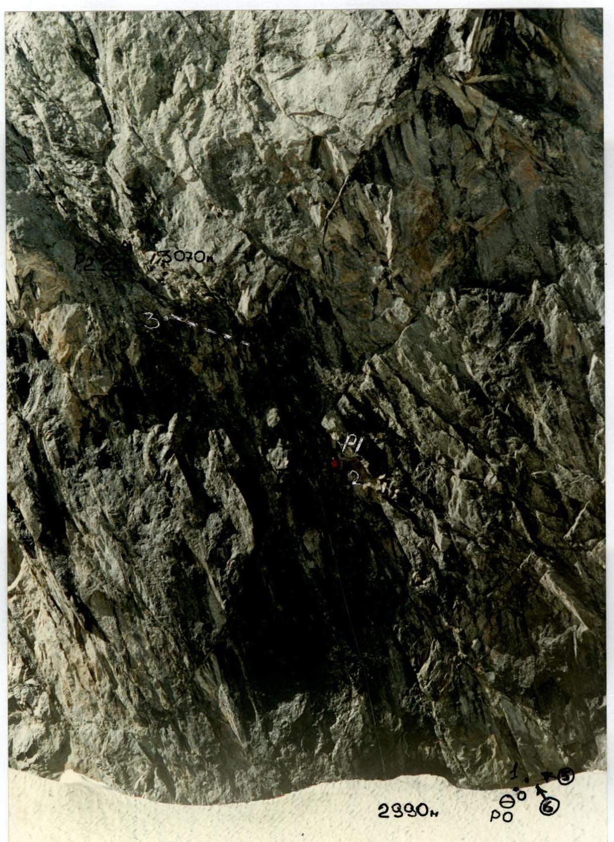
Photo 7. Lower part of the route. First two ropes. Nurbagandov–Velikanov team begins processing. Taken from the glacier. (section R0–R4) July 27, 1997, 11:00, "Zenit-E".
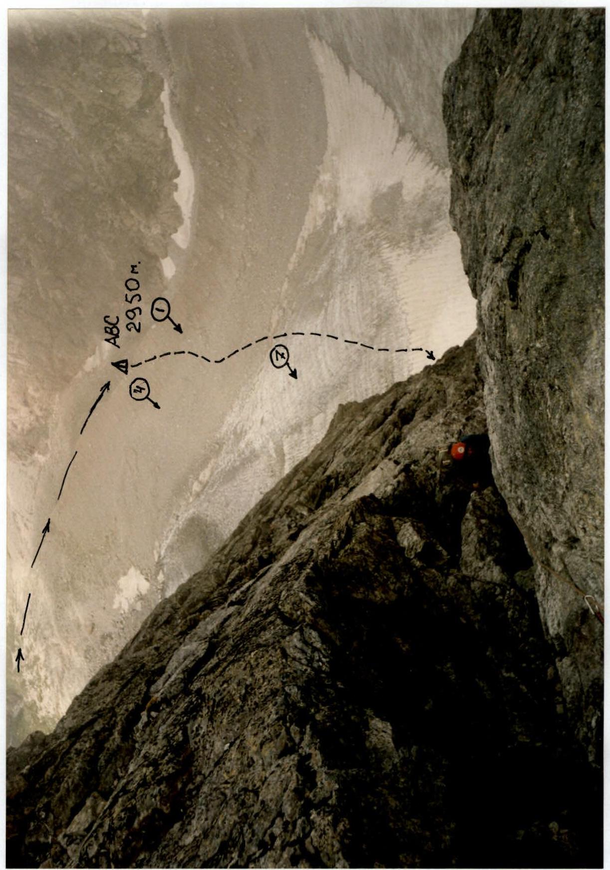
Photo 13. Climbing on fixed ropes on section R29–R31 (Dorro). Taken downward from station R16. July 30, 1997, 14:00, "Smena-Simvol".