- Climbing category — rock climbing
- Climbing area — Caucasus, 2.3. From Nakhar Pass to Chipperazau Pass
- Peak, its height, and climbing route — Nakhara Bolshoy, 3780 m via the center of the northwest wall
- Estimated difficulty category — 6th cat. diff.
- Route characteristics: height difference — 1130 m, including 1010 m of wall section; average steepness 73°, including 83° for the wall section. Section lengths: I cat. diff. — absent, II cat. diff. — 320 m, III cat. diff. — absent, IV cat. diff. — 15 m, V cat. diff. — 460 m, VI cat. diff. — 605 m.
- Pitons hammered: for belay and for creating I.T.O.
| Rock Pitons | Bolts | |
|---|---|---|
| for belay | 271 | 4 |
| for creating I.T.O. | 20 | - |
-
Total climbing hours — 57 hours.
-
Number of nights and their characteristics — 5 nights:
1st night: 2 people in hammocks, 4 people — sitting on shelves; 2nd and 3rd nights: 2 people semi-reclining in a "zdarka", 4 people — semi-reclining in a tent on platforms 4th night: 2 people — sitting in a "zdarka", 4 people — semi-reclining in a tent on inclined slabs 5th night: 2 people — sitting in a "zdarka", 4 people — semi-reclining in a tent on shelves.
-
Surname, name, patronymic of the team leader and participants, their two sports qualification:
- Kovtun Vasily Grigorievich MS — team leader
- Fomin Alexander Sergeevich MS
- Ushakov Vladimir Alekseevich MS
- Bodnik Vitaly Nikolaevich CMS
- Bychek Alexander Mikhailovich CMS
- Verba Alexander Andreevich CMS
-
Team coach — Magomedov Khadzhi Kurmanovich
-
Date of departure on the route and return — July 26 — processing; from July 31 to August 5 — ascent.
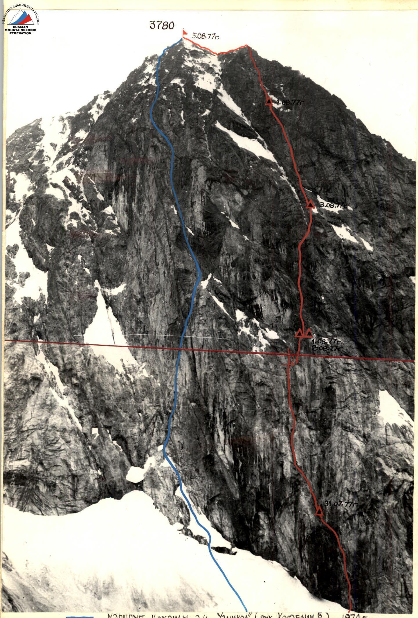
Route of the team a/l "Uznkol" (leader Korablin B.), 1974
Route of the team a/l "Domбай" (leader Kovtun V.), 1977
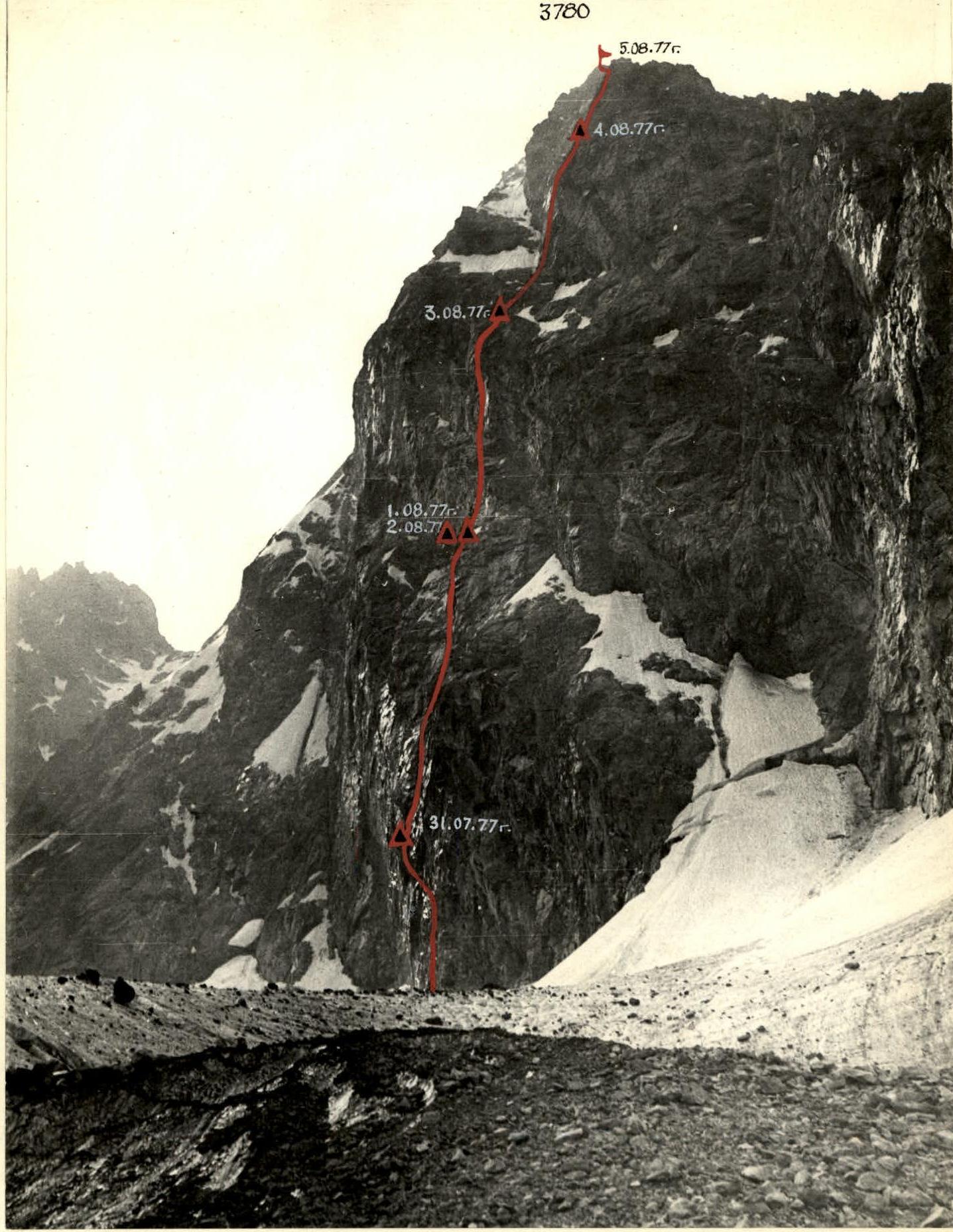
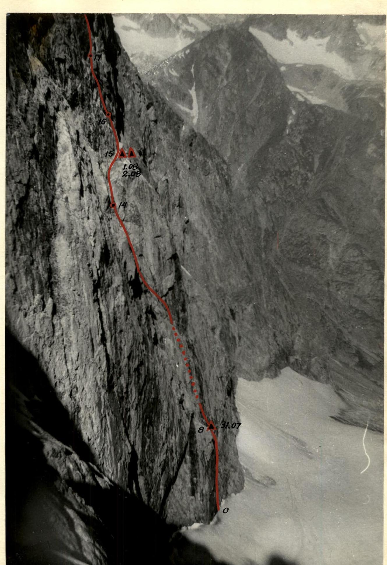
Photo of the route profile
July 26
At 6:00, the pair Bodnik-Verba left to process the route.
From the base camp, the path under the wall goes along a simple glacier and then along a gentle snowy ascent, leading to the randkluft under the northwest wall. There are no bridges or other crossings under the wall. The width of the randkluft is about 5 m. One has to descend into the randkluft. The descent into the randkluft is done via a rope fixed on ice axes to a depth of 10 m. There is a bridge here, which is used to cross to the wall. From here, the path is planned straight up along a vaguely expressed crack, turning into an internal corner higher up.
From the crack, we climb 10 m upwards, covered with rimed ice. The ice has to be chipped away. Then, through a minor bend, another 5 m with a slight deviation to the left (section R0–R1), we approach a hanging section. The crack turns into an internal corner, the right part of which strongly overhangs. The length of the overhanging part is about 8 m (section R1–R2). Climbing is very difficult. Behind the overhang, the steepness decreases, and, traversing about 12 m (section R2–R3) of this section, we approach the next overhang. The length of the overhanging part is 10 m (section R3–R4). Climbing is difficult; ladders have to be used. The overhang leads to a rock wall, along which we climb 10 m. Then the steepness of the wall increases, and we climb another 5 m (section R4–R5) and approach under a cornice. The length of the cornice is about 10 m. The overhang is a jagged, cracked rock face with water flowing through it. Only in this place, on the large cornice intersecting the entire lower belt of the wall, is some relief visible, and the projection of the cornice is the smallest. This is the only place on the lower bastion of the wall where it is possible to pass the cornice without using bolt pitons. We pass the cornice using ladders and a platform. Having overcome the cornice, we exit again onto a wall about 5 m long, which again leads to a cornice. The projection of the cornice is about 3.5–4 m, its length is 5 m (section R5–R6). The cornices are traversed using ladders and a platform. The cornice ends in a wall with a steepness of more than 90° and a length of 15 m. Climbing is very difficult (section R6–R7). The wall leads into a large internal corner. Water flows along the rocks of the internal corner. The rocks are smoothed, resembling "ram's foreheads". The right side of the internal corner overhangs, and movement is along its left part. We climb 25 m along the internal corner (section R7–R8) and exit onto the "Nosik". Here, as expected, there is a possibility to gather all group members. The plan outlined by the team is confirmed. Here, there is a possibility to organize a bivouac on small ledges.
From the "nosik", movement continues along the left side of the internal corner for about 20 m to the edge of the rock ascent, along which we climb another 15 m (section R8–R9). Climbing is difficult. The rocks are smoothed, resembling "ram's foreheads". Here, the ropes are fixed, and climbers descend from the wall in conditions of rapidly deteriorating weather. At 18:00, the pair descended from the wall and arrived at the base camp.
July 27–30
Severe weather. All days, snow and rain fell. Visibility is limited due to fog. The group stayed at the base camp. On July 30, in the second half of the day, signs of improving weather appeared.
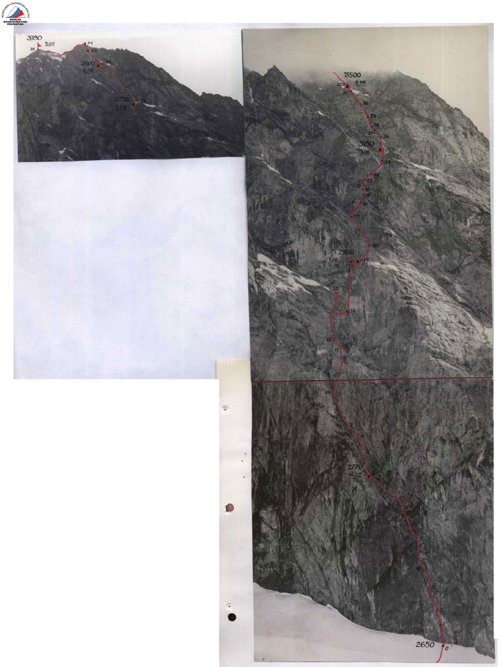
Photo of the route
July 31
The morning is fine. There are signs of stable weather.
At 13:00, the group begins the ascent in full composition. The first pair leaves, lightened, with the aim of processing another part of the route by the time the group reaches the "nosik".
When passing the processed sections, the leader has to go with abaalams, as the frozen ropes do not allow the use of jammers. The rope is like "icy threads" with a diameter of about 20 mm. Abaalams chipped away the ice, and subsequent participants could use jammers. The presence of abaalams in the group significantly facilitated passage on this section. While the foursome passed the processed section, hammered out pitons, and pulled up backpacks, the pair continued moving along the route.
The further route went along the internal corner. Having climbed 50 m along the internal corner (section R9–R10) along wet, smoothed, and partly icy rocks, the pair descended to the "nosik". By the time the pair descended, the foursome also reached the "nosik". Here, a bivouac:
- Two participants spent the night in hammocks.
- Four sat on small ledges.
For safety, double railings were натянуты. Here, the first control point is a small ledge on the left side of the "nosik". When passing this section, there was one rucksack extraction.
August 1
Rise at 5:30 AM. Ideal weather. Clear sky, cold. It is felt that the weather has stabilized. We pass the section processed the day before and continue moving along a steep rock ascent. The ascent is sheer, made of monolithic rocks. местами it is wet and there is rimed ice (section R10–R11). Having climbed 30 m, we exit into the area of a large niche on the wall. Here, the rocks are steep, smoothed, and wet. From here, we traverse left 10 m along a hanging crack (section R11–R12) to the left edge of the internal corner and vertically up about 55 m (section R12–R13). The internal corner, expanding, leads to a wide, rusty wall. The wall is monolithic, practically without relief, making free climbing impossible. Its steepness is about 115°. In the first part of the wall, about 20 m from where the group exited, a chimney with an overhang is visible. This is the only place where it is possible to pass this section without using bolt pitons.
To get to the chimney, we have to make a pendulum swing to the right about 20 m along smoothed rocks. For reliable belay during the pendulum swing, two bolt pitons are hammered into the rusty wall. The pendulum, like all movement, is done on a double rope. The first 20 m of the chimney have a steepness of about 85°. There are handholds. Further, the steepness increases to about 95°, and the next 30 m present significant difficulty. Climbing is very difficult. At the top of the chimney, there is a rock plug. It is bypassed on the right (section R14–R15). Immediately behind the plug, there is a small platform where we planned to bivouac. Indeed, here it is possible to organize a fairly comfortable bivouac. At 18:00, all participants climbed onto the ledge. After "construction" work, a small platform is prepared, on which a tent is set up. Four people can semi-lie in the tent. The other two spent the night in a "zdarka" on a small ledge near the tent. Here is the second control point. On this day, there were 2 rucksack extractions.
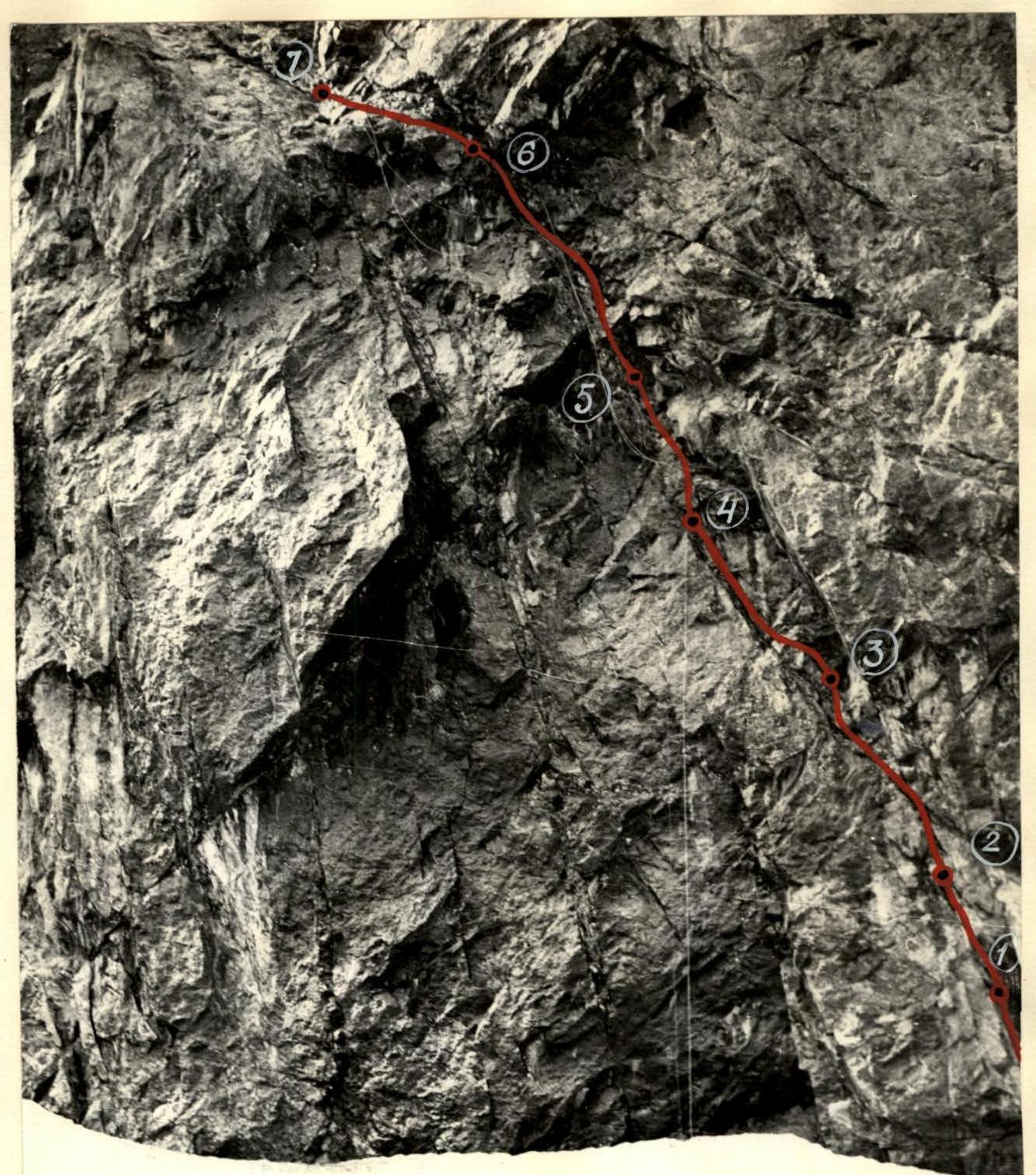
Beginning of the route (sections R0–R7)
Profile of the lower part of the route
August 2
Rise at 6:00. Excellent weather. At 8:00, the trio Bodnik–Bychek–Verba left to process the second belt of the wall.
From the platform, vertically up about 12 m, overcoming 2 small hanging sections. Further, left-up 15 m along wet slabs, leading under the wall. The rocks on the wall are also wet. Along them, about 15 m further, we approach a small ledge. Along it, about 3 m (section R15–R16) with a slight deviation to the left, we approach under the second wall. The steepness of the first section on this wall is not more than 90°. Along the wall, we climb 30 m and exit onto a small ledge where 2 people can stand. From the ledge, 5 m up along a hanging crack and further 20 m of very difficult climbing along the wall. The rocks are monolithic, smoothed, and rusty. The steepness of the wall decreases slightly, and, having climbed another 15 m (section R16–R17), we approach under one of the most complex sections of the route — a mirror-smooth wall.
The wall is black, with microscopic handholds, monolithic. In the upper part, the entire belt is intersected by a cornice. Movement goes up with a slight deviation to the right along a narrow crack. The length of the section is 30 m (section R17–R18). Climbing is very difficult:
- In some places, pitons have to be used as supports.
- In many places, one has to climb on friction.
The crack goes along the entire wall and leads to the cornice. The projection of the cornice is the smallest here. The cornice is cut by a crack, along which movement is planned.
The already difficult climbing is complicated by the fact that water flows through the cornice at this point. But there is no other path. In other places, the projection of the cornice is much larger. Here, the projection of the cornice is about 3.5–4 m, the length of the cornice is about 10 m (section R18–R19).
When passing the cornice, the following are used:
- platforms
- ladders
For reliable belay, 2 bolt pitons are hammered in. Having passed the cornice, we continue movement along a narrow crack straight up 20 m (section R19–R20).
The crack leads to another small cornice. Its length is about 5 m (section R20–R21). The rocks are monolithic. The cornice is passed using:
- a platform
- ladders
After the cornice, we find ourselves on a narrow ledge about 3 m long. Here is a convenient place for rucksack extraction. A rucksack extraction point is organized, ropes are fixed, and climbers descend to bivouac at 16:00. We spend the night at the same place.
August 3
Rise at 6:00. The morning is transparent, cold. The weather is fine. At 8:00, the entire group leaves to continue the ascent. The pair goes up to further progress along the path, and the foursome follows the laid path, pulling up rucksacks, removing pitons, and taking down ropes.
From the end of the ledge, we move up to the right 10 m (section R21–R22) in the direction of a narrow vertical crack on the wall. Further, right-up 15 m (section R22–R23) along the crack. The crack turns into a wall, and along it another 15 m to a narrow chimney. Along the chimney, about 25 m (section R23–R24). The chimney leads to the base of a wide, destroyed wall. The wall, 25 m long (section R24–R25), leads to a small ledge where, as planned, it is possible to organize a bivouac. We called this ledge the second "nosik". At 16:30, the entire group climbed onto the "nosik". Four people worked on arranging the bivouac, and the pair passed the section above and hung ropes.
To the left-up from the ledge, where the bivouac is organized, a steep ice-snow couloir goes, along which pieces of ice and stones periodically fly. Movement along it presents great danger. Therefore, as planned, we continue movement along the wall:
- From the bivouac site straight up along the rock rib, about 75 m long (section R25–R26), to the beginning of the wall of the upper rock belt.
- The rocks are monolithic, strong, dry.
- Climbing is pleasant.
Here, at the base of the wall, the ropes are fixed, and the pair descends to bivouac.
We spent the night:
- Four — in a semi-reclining position in a tent.
- Two — in a "zdarka" on ledges.
On this day, there were 2 rucksack extractions.
August 4
We leave at 9:00. The weather is fine. It's cold. We pass the rock rib and approach the wall. The wall is cut by a wide and deep internal corner. Along the left part of the internal corner, we climb 35 m (section R26–R27) and exit under a cornice, which ends the internal corner. The cornice is bypassed along a crack on the left. The crack is about 20 cm wide and goes vertically up. About 17 m later, the crack turns into a rock ascent with an overhang. The length of the ascent is about 8 m (section R27–R28). Both the crack and the ascent are wet. Climbing is difficult. For belay, channels and wedges are used well in the crack. Passing the ascent, we exit to a rock wall with very poor relief. Along the wall, we climb about 45 m (section R28–R29). A narrow crack goes along the wall, and movement is organized through pitons hammered into this crack. Further, again along the internal corner, about 35 m (section R29–R30). In the lower part, the internal corner has a steepness of more than 90° and is wet, as water flows along its left side. Further, the steepness decreases, and movement continues along the internal corner for another 40 m (section R30–R31) and we exit onto the edge of a ledge going to the left. The ledge is snow-covered and almost horizontal. We traverse along the ledge about 15 m (section R31–R32), organize a bivouac on small ledges. All participants reached this place by 17:00. Here is the third control point.
While the other participants were catching up with the bivouac site, the pair processed the further path. The internal corner ends in the area of the ledge, and the further path goes along a steep, dissected wall with couloirs. The wall is steep. There are fragile handholds, so movement goes very cautiously. Along the wall, about 120 m (section R32–R33) is passed, ropes are fixed, and the pair descends to the ledge where the bivouac was organized. Four people lay in the tent, and two — in a "zdarka".
On this day, there was one rucksack extraction.
August 5
Despite the cold, windy morning, we leave at 6:30. We pass the section processed the day before and approach the pre-crest ascent. Here, the steepness of the wall increases slightly, but varied relief and abundance of handholds and cracks allow moving up fairly quickly. We climb along the wall about 50 m (section R33–R34) and exit onto the ridge. Finally, the wall is behind. Along the несложному гребню simultaneously climb to the top. At 10:20, we were on the summit.
Along the known path, we begin the descent from the summit. The weather starts to deteriorate. The group descended to the base camp at 15:00 on the same day.
 Ascent on section R17–R18 ("Mirror")
Table № I
Main characteristics of the ascent route to v. Nakhara Bolshoy via the center of the northwest wall

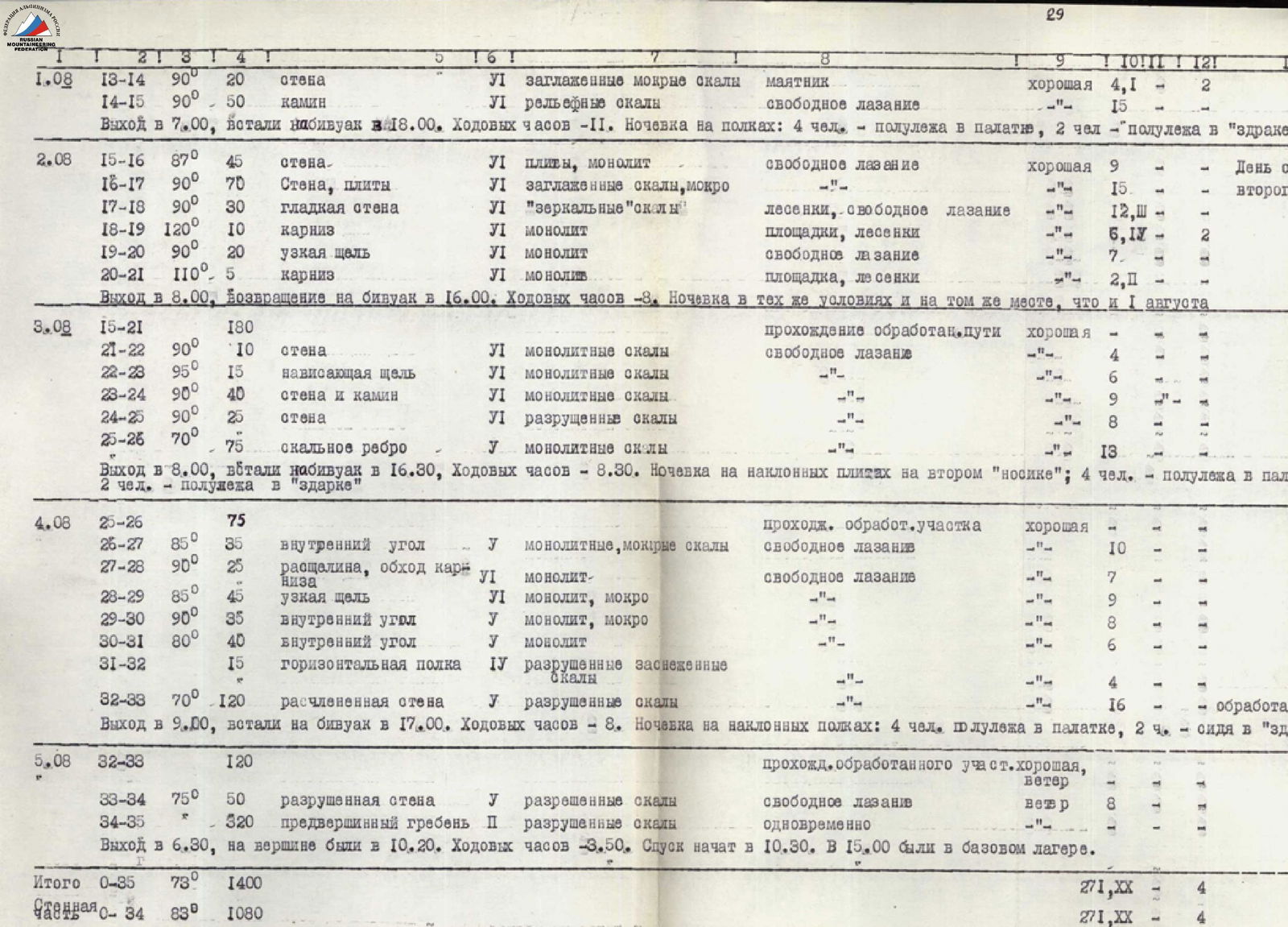
| Date | Section | Average steepness in degrees | Length in m | Character of relief | I difficulty | Method of overcoming | Weather conditions | Rock Pitons | Ice Pitons | Bolt Pitons | Note |
|---|---|---|---|---|---|---|---|---|---|---|---|
| 26.07 | R0–R1 | 90° | 15 | Crack | VI | Free climbing | Overcast | 8,1 | — | — | Processing day |
| R1–R2 | 100° | 8 | Cornice | VI | Free climbing | — | 2,1 | — | — | ||
| R2–R3 | 80° | 12 | Internal corner | VI | Free climbing | — | 4 | — | — | ||
| R3–R4 | 105° | 10 | Cornice | VI | Ladders and free climbing | — | 5,1 | — | — | ||
| R4–R5 | 87° | 15 | Wall | VI | Free climbing | — | 7 | — | — | ||
| R5–R6 | 110° | 20 | Cornice and wall | VI | Ladders, platform | — | 8 | VI | — | ||
| R6–R7 | 92° | 15 | Wall | VI | Free climbing and ladders | — | 5,1 | — | — | ||
| R7–R8 | 80° | 25 | Internal corner | VI | Free climbing | — | 8 | — | — | ||
| R8–R9 | 90° | 35 | Internal corner | VI | Free climbing | Rain | 9 | — | — | ||
| Departure at 6:00, return to base camp at 18:00. Climbing hours –12. Overnight in base camp in tents | |||||||||||
| 27–30.07 | Bad weather | Rain, snow, fog. | Stayed at base camp. Did not approach the wall | ||||||||
| 31.07 | R0–R8 | 120 | Icy rocks and ropes | Passage of processed section | Fine | — | — | — | Entire group reaches "nosik" | ||
| R9–R10 | 80° | 50 | Internal corner | V | Free climbing | — | 12 | — | — | Processed section | |
| Departure at 13:00, bivouac at 19:00. Climbing hours – 6. Overnight on "nosik" ledges: 4 people – sitting on ledges, 2 people – in hammocks | |||||||||||
| 01.08 | R8–R10 | 85 | Wet rocks | Passage of processed section | Fine | — | — | — | |||
| R10–R11 | 90° | 30 | Internal corner, right side | VI | Free climbing | — | 12 | — | — | ||
| R11–R12 | 95° | 10 | Hanging crack | VI | Free climbing | — | 3 | — | 1 | ||
| R12–R13 | 80° | 55 | Internal corner | V | Free climbing | — | 10 | — | — | ||
| R13–R14 | 90° | 20 | Wall | VI | Pendulum | Fine | 4,1 | — | 2 | ||
| R14–R15 | 90° | 50 | Chimney | VI | Free climbing | — | 15 | — | — | ||
| Departure at 7:00, bivouac at 18:00. Climbing hours – 11. Overnight on shelves: 4 people – semi-reclining in tent, 2 people – semi-reclining in "zdarka" | |||||||||||
| 02.08 | R15–R16 | 87° | 45 | Wall | VI | Free climbing | Fine | 9 | — | — | Processing day of second belt |
| R16–R17 | 90° | 70 | Wall, slabs | VI | — | — | 15 | — | — | ||
| R17–R18 | 90° | 30 | Smooth wall | VI | Ladders, free climbing | — | 12,III | — | — | ||
| R18–R19 | 120° | 10 | Cornice | VI | Platforms, ladders | — | 6,1 | — | 1 | ||
| R19–R20 | 90° | 20 | Narrow crack | VI | Free climbing | — | 7 | — | — | ||
| R20–R21 | 110° | 5 | Cornice | VI | Platform, ladders | — | 2,1 | — | — | ||
| Departure at 8:00, return to bivouac at 16:00. Climbing hours – 8. Overnight in same conditions and place as on August 1 | |||||||||||
| 03.08 | R15–R21 | 180 | Passage of processed path | Fine | — | — | — | ||||
| R21–R22 | 90° | 10 | Wall | VI | Free climbing | — | 4 | — | — | ||
| R22–R23 | 95° | 15 | Hanging crack | VI | — | — | 6 | — | — | ||
| R23–R24 | 90° | 40 | Wall and chimney | VI | — | — | 9 | — | — | ||
| R24–R25 | 90° | 25 | Wall | VI | — | — | 8 | — | — | ||
| R25–R26 | 70° | 75 | Rock rib | V | — | — | 13 | — | — | ||
| Departure at 8:00, bivouac at 16:30. Climbing hours – 8.30. Overnight on inclined slabs on second "nosik"; 4 people – semi-reclining in tent, 2 people – semi-reclining in "zdarka" | |||||||||||
| 04.08 | R25–R26 | 75 | Passage of processed section | Fine | — | — | — | ||||
| R26–R27 | 85° | 35 | Internal corner | V | Free climbing | — | 10 | — | — | ||
| R27–R28 | 90° | 25 | Crack, cornice bypass | VI | Free climbing | — | 7 | — | — | ||
| R28–R29 | 85° | 45 | Narrow crack | VI | — | — | 9 | — | — | ||
| R29–R30 | 90° | 35 | Internal corner | V | — | — | 8 | — | — | ||
| R30–R31 | 80° | 40 | Internal corner | V | — | — | 6 | — | — | ||
| R31–R32 | 15 | Horizontal ledge | IV | — | — | 4 | — | — | Processed section | ||
| R32–R33 | 70° | 120 | Dissected wall | V | — | — | 16 | — | — | ||
| Departure at 9:00, bivouac at 17:00. Climbing hours – 8. Overnight on inclined shelves: 4 people semi-reclining in tent, 2 people sitting in "zdarka" | |||||||||||
| 05.08 | R32–R33 | 120 | Passage of processed section | Fine, wind | — | — | — | ||||
| R33–R34 | 75° | 50 | Destroyed wall | V | Free climbing | Wind | 8 | — | — | ||
| R34–R35 | 320 | Pre-summit ridge | II | Simultaneously | — | — | — | — | |||
| Departure at 6:30, on summit at 10:20. Climbing hours – 3:50. Descent started at 10:30. At 15:00, we were at base camp. |
| Total | R0–R35 | 73° | 1400 | Rock | 271, XX |
| Bolts | 4 | ||||
| Wall section | R0–R34 | 83° | 1080 | Rock | 271, XX |
| Bolts | 4 | ||||
| Total climbing hours to summit — 57. Nights on wall — 5 | |||||
| TEAM CAPTAIN V. KOVTUN | |||||
| TEAM COACH KH. MAGOMEDOV |