To the championship of Moscow 1973
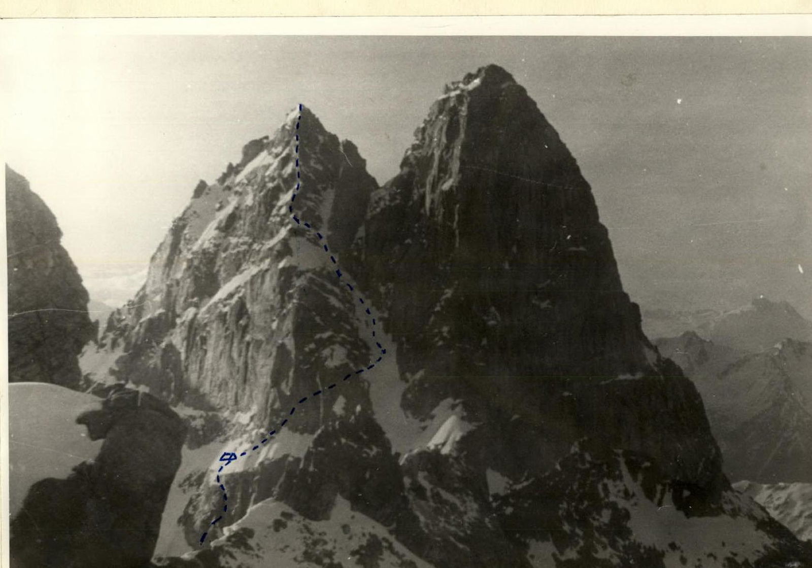
TWIN PEAKS VIA NORTH-NORTH-WEST FACE 5B cat. dif. (Western Caucasus)
Dedicated to the 50th anniversary of Soviet mountaineering
Team of Moscow City Council of Spartak Volunteer Sports Society
Kavunenko V.D. — Master of Sports of the USSR — team leader Parfenov V.P. — Candidate for Master of Sports Pozdnyakov A.A. — 1st sports category Ivanov N.V. — 1st sports category
July 18–24, 1973
Characteristics of the Uzunkol area
The area is dominated by purely rocky peaks and routes. Glaciers in the area are short and strongly pulled up, with large bergschrunds and icefalls. Rock routes on peaks located in the Main Caucasian Range are characterized by strong monolithic rocks. Peaks located in the spurs are heavily destroyed and practically snowless. From the southern side, all peaks are cut off by walls up to 1200 m high. The gorges have a characteristic feature for this area — they are mostly flat and even, with calm river flows (Myrd, Kichkinokol, Western Kichkinokol, etc.).
The climate of the Uzunkol area is largely similar to the weather conditions in Dombay. At the same time, the immediate proximity of Elbrus in combination with local factors:
- significant height above sea level (Uzunkol shelf 2100 m, Glade Gondaray 2200 m),
- enclosed position among mountain massifs,
- a wide variety of local winds
— leaves its characteristic mark on the weather conditions of the area.
In winter, snow falls earlier here and remains in most gorges until the end of May. The summer period is characterized by stable sunny weather. Good sunny days are established from June 15–20 and continue until July 7–10, then approximately a week of rainy and cloudy weather — and again the sun shines until August 12–15. The air temperature during this period rises to 28–30° above zero.
Then follows:
- Until August 20 — a slight decline in heat;
- From August 20 to September 7–12 — a period of even clear weather;
- From approximately September 12–15 — a sharp deterioration in weather.
History of the conquest of Twin Peaks
The strict sheer walls of Twin Peaks have long attracted the attention of mountaineers. The first ascent to the peak was made in 1937 by a group led by V. A. Budanova. In the same year, the south wall of the Eastern peak was climbed (4B cat. dif.).
In 1968, a group led by Artsishevsky climbed the "edge" to the Western peak, and a group from the Krasnoyarsk Spartak sports club made an ascent to the Western peak of Twin Peaks via the south wall (5B cat. dif.).
The north-west wall of Twin Peaks remained unconquered. Several attempts were made to climb this route, but they all ended in failure.
In 1972, a team from Moscow Spartak spent seven days under the wall waiting for good weather. On the eighth day, the group started the route. In one day, they climbed the lower rocky belt, but by evening, the weather worsened again, and two days later, without waiting for an improvement in the weather, the group descended.
In 1973, the Moscow Spartak team again planned the same route via the north-west wall to Twin Peaks. Upon arrival at the camp, we learned that a team from Poland was preparing to climb the same route. Three days later, they returned, having overcome about 80 m of the lower part of the wall. The Poles informed us that:
- the wall was covered with ice;
- every day from 12:00, a real waterfall appeared on the rocks.
They also "delighted" us with the news that they had removed all our previous year's pitons, but left two loops for rappelling.
And again, we are under the wall. And again, as last year, the weather did not allow us to start the route. Leaving all the equipment, the group returned to the camp. For the third time, we approached the wall on July 18. The weather was not ideal, but we had no more time to wait.
Description of the ascent to Twin Peaks via the N-N-W face
R0–R1
On July 19, at dawn, we started the route. We overcame the bergschrund and traversed to the right (70 m) along a snowy slope (40°). We approached the second bergschrund.
R1–R2
A very dubious bridge led to a sheer 3-meter ice wall. With the help of ice screws and ladders, we climbed the wall and reached a steep ice slope.
Along the ice slope, we traversed to the right and upwards (30 m, 50°) to the beginning of the wall.
Along destroyed steep rocks (60 m), we climbed to a small ledge. Here, we found a loop left by Polish mountaineers.
R2–R3
30 m — a difficult traverse to the right with piton belays. 4 m of sheer rocks and a complex traverse to the right (10 m) along a hanging crack.
R3–R4
In front of us was a smooth, overhanging section (5 m). In the middle part, a piton hammered by us last year was visible. (It's good that the Poles didn't reach here). The wall led to a steep internal corner. 40 m of difficult climbing on rocks covered with ice.
R4–R5
6 m — a difficult traverse to the right and directly upwards along difficult rocks for 50 m.
R5–R6
Further ascent went along strongly destroyed rocks of medium difficulty (40 m). Above, there was a belt of completely destroyed rocks. Movement required maximum caution. After 20 m, we reached a ledge where all participants could gather. (Total length of the section is 60 m)
R6–R7
A short traverse to the right (3 m) and along an inclined, thrown-out crack 12 m upwards. A convenient large ledge. Here, on a bolt hanger, we secured a can and left a note.
R7–R8
40 m of very difficult climbing without backpacks along strong rocks, and we approached the base of a steep snowy ledge.
- We pulled out our backpacks.
R8–R9
A 15-meter ascent along a steep (50°) snowy ridge to the rocks. Here, we dug out a site for a tent and spent the night.
R9–R10
July 20. Along wet rocks with ice, we reached a narrow ledge. The ice was covered with a thin layer of snow. Further movement along the ledge to the right (60 m). Sections with overhanging rocks were climbed by crawling. Then 20 m to the right and upwards along strongly destroyed rocks covered with ice.
R10–R11
Another 40 m of complex traverse, and we reached an internal corner covered with a thin layer of ice.
R11–R12
30 m of difficult climbing upwards along wet rocks (80°), covered with ice. Then 2 m of a sheer wall were climbed using ladders, and we reached a smooth, inclined slab covered with ice — very difficult (7 m). 5 m upwards along a sheer internal corner covered with ice. Traverse to the left along ice to rocks to a rocky ledge, on which two people could stand. We pulled our backpacks up to this ledge.
R12–R13
Directly upwards, there was a narrow, vertical crack (45 m). The lower part was climbed using artificial aids. Further, there was difficult climbing along the crack.
In the middle of the crack:
- two large, jammed stones, which were very dangerous to use;
- we had to bypass them along a sheer wall with very small holds.
Further, 10–15 m upwards along the crack to a small ledge, where we could organize the pulling of backpacks.
R13–R14
10 m to the right and upwards along smooth rocks like "ram's foreheads", on which many loose stones were lying, covered with snow. We reached a steep snowy ledge. The weather was deteriorating. In 2 hours, we dug out a site. Wet snow was falling.
July 21. Wet snow was falling. Visibility was zero. We spent the whole day in the tent.
R14–R15
July 22. The weather was average. The exit to the pre-summit ridge did not present particular difficulties, but the rocks were so clogged with wet snow that it was very difficult to organize reliable belays during movement. We went a complex traverse 60 m to the right and entered a snow-ice couloir.
R15–R16
250 m along the couloir with piton belays on rocks. In the place where the couloir turned sharply to the right, we climbed upwards to the rocks. Further, there was a traverse to the left and upwards along destroyed rocks covered with snow and ice (20 m) to the ridge. Here, there was a ledge on which the whole group could gather.
R16–R17
Further upwards along the steep, destroyed ridge (30 m). It was difficult to organize reliable belays. Wet snow covering the rocks greatly hindered movement.
R17–R18
5 m ascent along a steep (80°) monolithic wall with good holds. Then, using a pendulum, we moved to the right to a steep ledge covered with snow. We traversed the ledge diagonally to the right and upwards, after which 20 m of easy climbing along destroyed rocks led to the pre-summit. (Total length of the section is 35 m)
R18–R19
A 10-meter sporty descent to a snowy saddle. Then we traversed 20 m to the right along the boundary between snow and rocks. We climbed onto rocks and traversed to the right and upwards for 20 m to a large rocky ledge. Climbing was not difficult, with many cracks where pitons could be hammered.
R19–R20
15 m of easy climbing along a rocky groove. Further ascent to the summit along a flattening ridge did not present difficulties.
July 23. The weather was good.
We descended from the Eastern peak via the 4B cat. dif. route. At 18:00, we stopped for the night under the Dakar pass.
July 24. Return to the Uzunkol tourist camp.
Conclusion on the route
The route via the N-N-W face to Twin Peaks is logical, with a wide variety of rock relief forms. Climbing this route requires participants to have good physical and tactical preparation. Some sections were climbed without backpacks using artificial aids.
Attention should be paid to:
- the rockfall danger of this route.
Experience of climbing:
- In 1972, due to strong snowmelt, the route was extremely dangerous.
- In 1973, there were few randomly falling stones, but movement along sections of destroyed rocks required maximum caution.
This route can be recommended for groups with experience in wall climbing.
The group believes that this route should be classified as a 5B cat. dif. route.
Evaluation of participants' actions
For most participants, this was one of the most challenging ascents.
In terms of physical and technical preparation, the participants were ready for such an ascent.
Nikolai Ivanov — well-prepared, accurate. Can participate in ascents of higher categories of difficulty.
Alexander Pozdnyakov — excellent on rocks and ice, but does not always correctly assess the difficulty of the route. Can be a participant in ascents of the highest category of difficulty under certain conditions.
Total time spent climbing: 32.5 hours
Total pitons hammered: rock 74 pcs. ice 6 pcs.
East, West
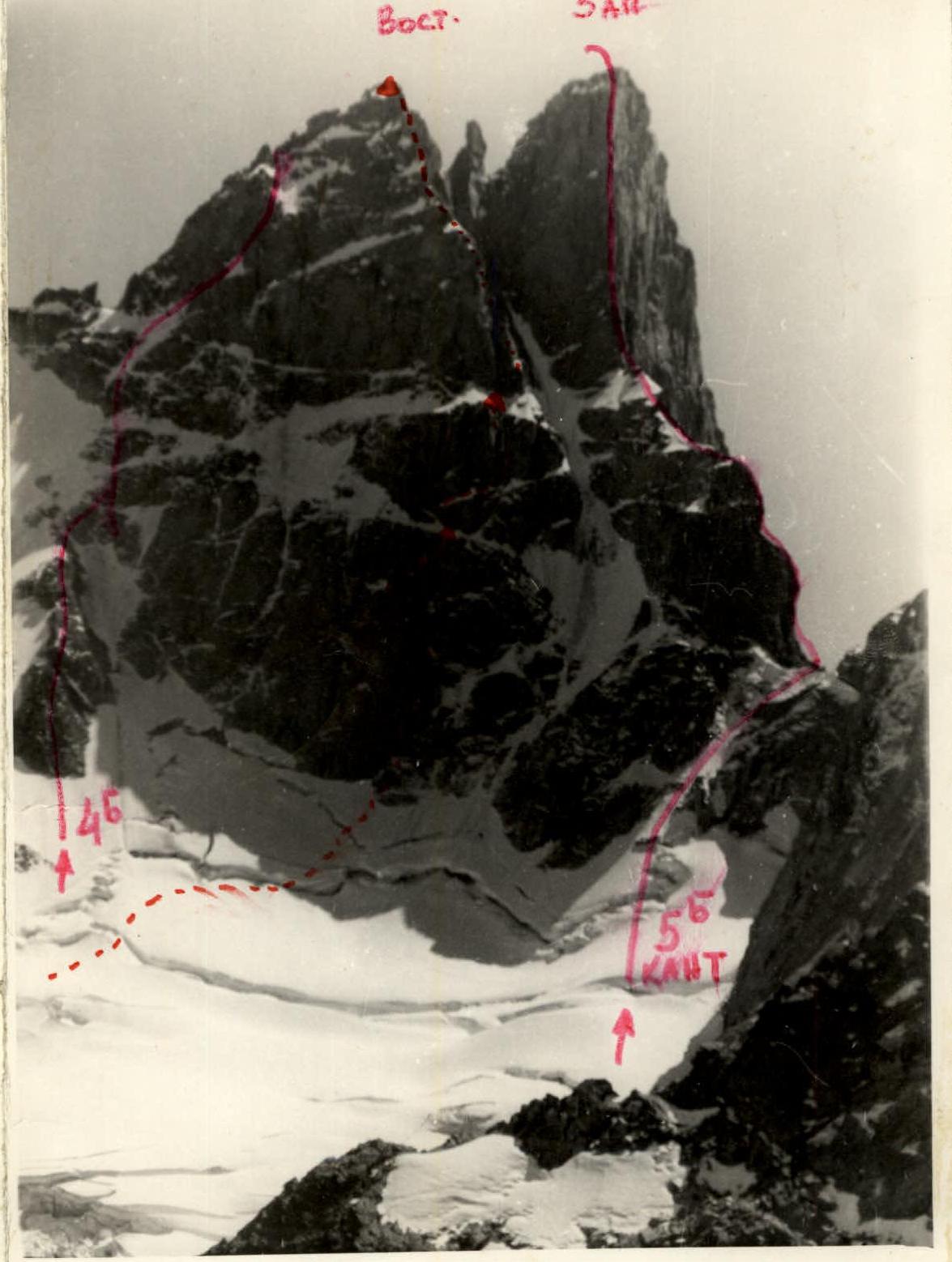
Ascent to the peaks