Ascent Passport
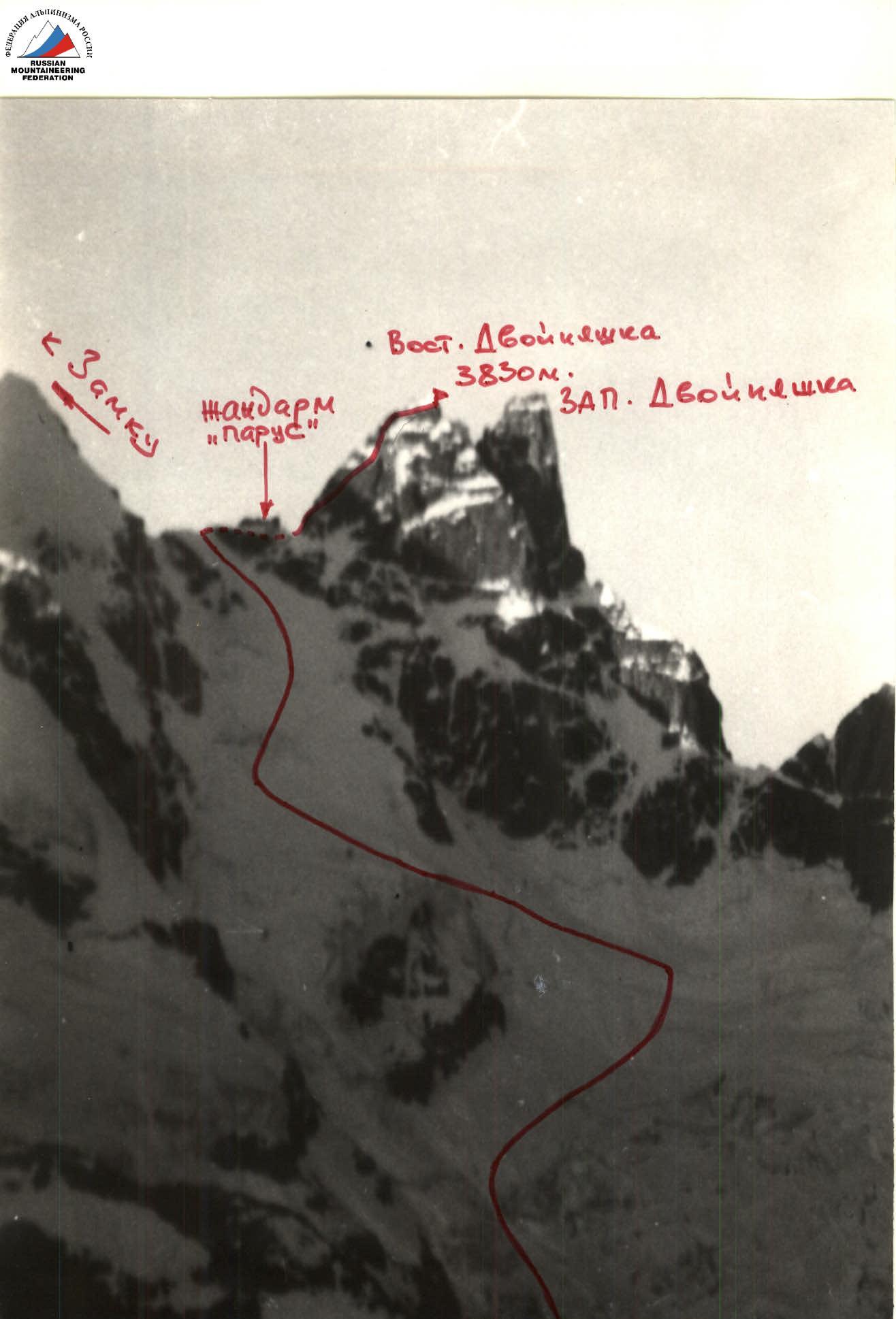
I. Ascent class - rock II. Ascent area - W. Caucasus from Klukhor Pass to Azau Pass. III. Peak - Dvoynyshka 3830 m. East peak. IV. Proposed difficulty category - 5A V. Route character - combined. VI. Route characteristics:
- height difference - 940 m.
- route length - 1490 m.
- incl. snow-ice sections - 1150 m.
- average steepness of snow-ice sections - 43°
- average steepness of rock ridge section - 75°
- length of sections 5 cat. diff. on rock section - 265 m. VII. Pitons hammered for belay:
- rock: 38, for ITO - 4, total - 42
- ice: 32, for ITO - 2, total - 34
- chocks: 11, for ITO - 3, total - 14 VIII. Number of travel days - 2 IX. Number of travel hours - 19 X. Overnight stays - one, on a saddle, in a tent. XI. Group composition, qualification of participants and leader: GULA Anatoly Vasilievich - 1st sports category, leader RYBAKOV Alexander Vasilievich - Candidate for Master of Sports, participant (2nd category instructor) SENETSKY Vitaly Petrovich - Candidate for Master of Sports, participant (1st category instructor) VOLOVIK Yuri Georgievich - 1st sports category, participant XII. Group coach - Senetsky V.P. - Candidate for Master of Sports. XIII. Date of departure on the route - July 9, 1983. XIV. Date of return - July 11, 1983.
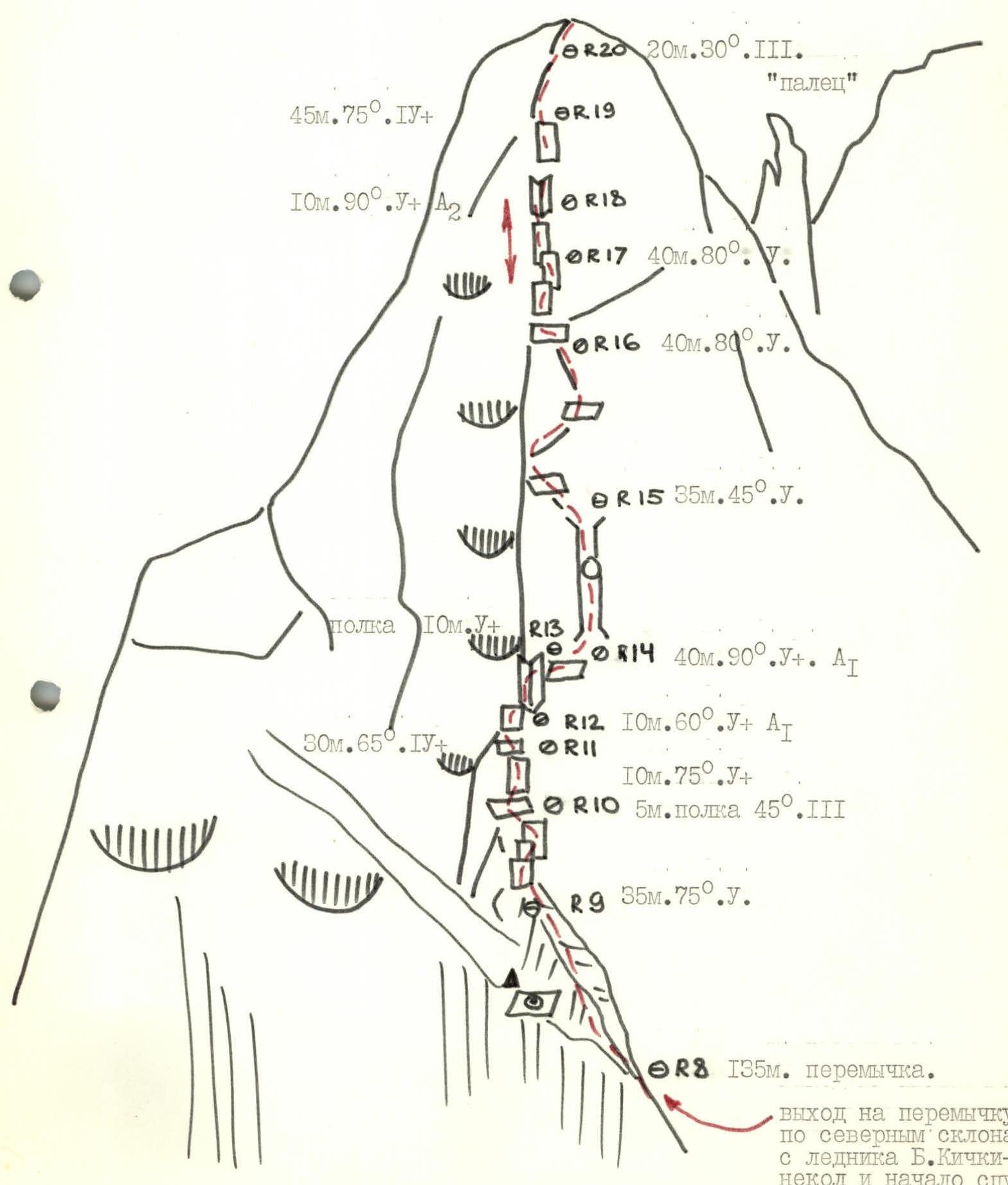
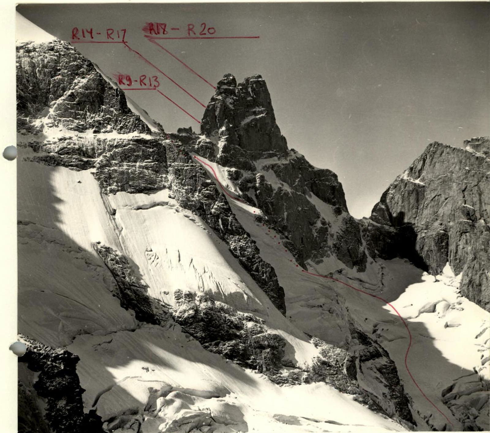
R14–R17 R18–R20 R9–R13
"General view of the peak and route to the saddle from B. Kichkinekol glacier".
"Profile of the upper part of the route - exit to the saddle on snow-ice slopes".
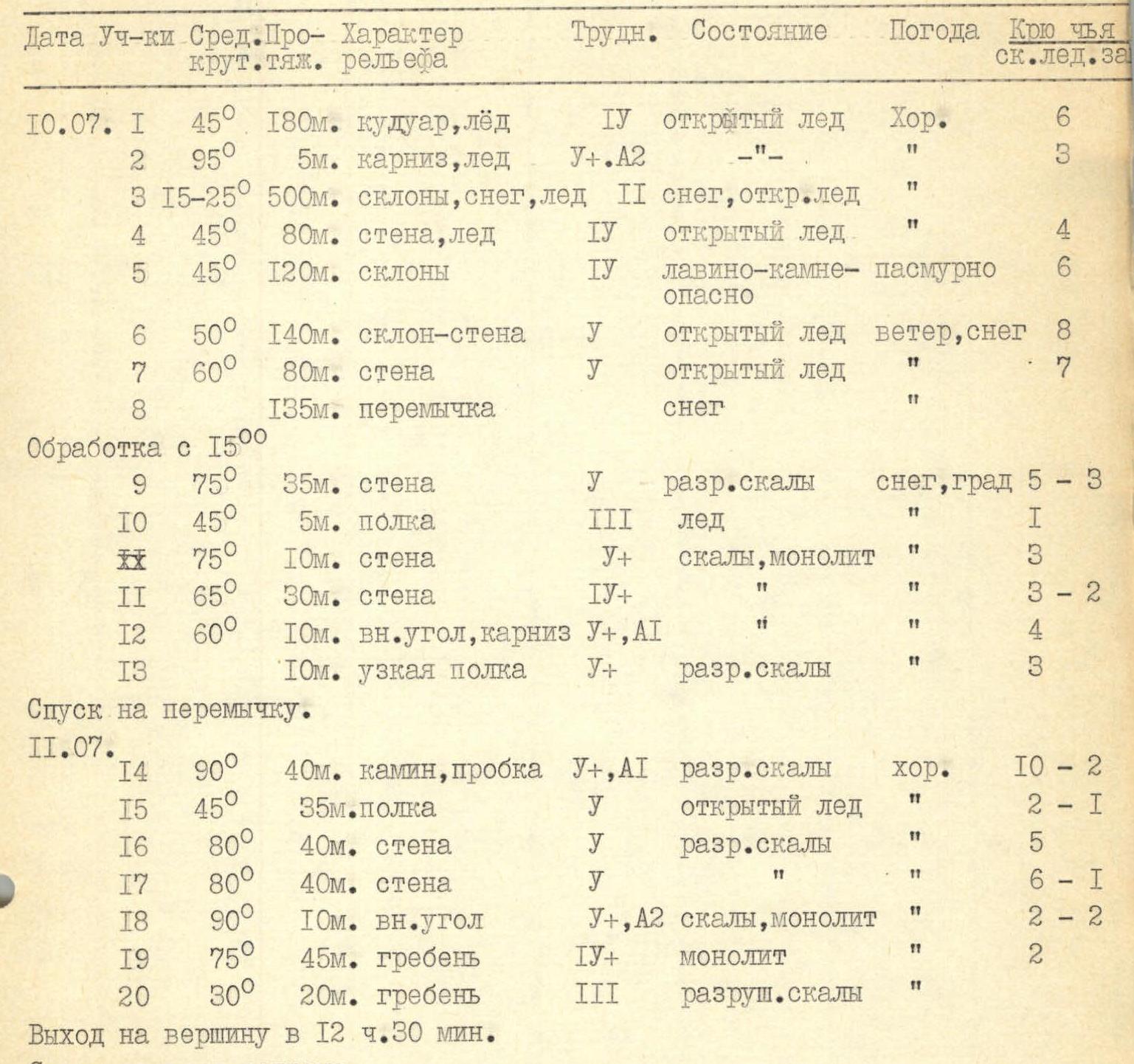
"Table of main characteristics of the ascent route"

| Date | Section | Average steepness | Length | Terrain character | Difficulty cat. | Condition | Weather | Travel time | Ice screw cat. |
|---|---|---|---|---|---|---|---|---|---|
| July 10 | R1 | 45° | 180 m | couloir, ice | IV | exposed ice | Good | 6 | – |
| R2 | 95° | 5 m | cornice, ice | V+, A2 | «–» | «–» | 3 | – | |
| R3 | 15–25° | 500 m | slopes, snow, ice | II | snow, exposed ice | «–» | – | – | |
| R4 | 45° | 80 m | wall, ice | IV | exposed ice | «–» | 4 | – | |
| R5 | 45° | 120 m | slopes | IV | avalanche-rock hazard | cloudy | 6 | – | |
| R6 | 50° | 140 m | slope-wall | V | exposed ice | wind, snow | 8 | – | |
| R7 | 60° | 80 m | wall | V | exposed ice | «–» | 7 | – | |
| R8 | – | 135 m | saddle | – | snow | «–» | – | – | |
| Processing from 15:00 | |||||||||
| R9 | 75° | 35 m | wall | V | loose rocks | snow, hail | 5 | 3 | |
| R10 | 45° | 5 m | ledge | III | ice | «–» | 1 | – | |
| R11 | 75° | 10 m | wall | V+ | rocks, monolith | «–» | 3 | – | |
| R12 | 65° | 30 m | wall | IV+ | «–» | «–» | 3 | 2 | |
| R13 | 60° | 10 m | inner corner, cornice | V+, A1 | «–» | «–» | 4 | – | |
| – | 10 m | narrow ledge | V+ | loose rocks | «–» | 3 | – | ||
| Descent to the saddle. | |||||||||
| July 11 | R14 | 90° | 40 m | chimney, plug | V+, A1 | loose rocks | Good | 10 | 2 |
| R15 | 45° | 35 m | ledge | V | exposed ice | «–» | 2 | 1 | |
| R16 | 80° | 40 m | wall | V | loose rocks | «–» | 5 | – | |
| R17 | 80° | 40 m | wall | V | «–» | «–» | 6 | 1 | |
| R18 | 90° | 10 m | inner corner | V+, A2 | rocks, monolith | «–» | 2 | 2 | |
| R19 | 75° | 45 m | ridge | IV+ | monolith | «–» | 2 | – | |
| R20 | 30° | 20 m | ridge | III | destroyed rocks | «–» | 2 | – | |
| Reach the peak at 12:30. | |||||||||
| Descent via the ascent route. |
"Route scheme to East Dvoynyshka peak via the east ridge 5A (glacier section, exit to the saddle)".
"Route scheme to Dvoynyshka peak via the east ridge - section from the saddle".
"View of the summit tower of East Dvoynyshka".


