Passport
-
Rock climbing category.
-
Western Caucasus, Kichkinekol gorge.
-
Peak "Dalar", via the northern wall, Snesarev's route.
-
Third ascent — Category 5B difficulty.
-
Elevation gain — 895 m, length — 1050 m.
Length of sections: Category 6 difficulty — 570 m. Average steepness of the route is 75°.
-
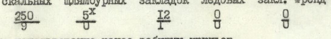
Pitons driven:
- rock — 250
- bolted — 5 (x)
- chocks — 12
- ice — 0
- Friends — 0
x — use of previously driven pitons
-
Team's total climbing hours — 40, days — 4.
-
Overnight stops:
- at the first control point
- on the summit of the "finger"
- at the exit from the wall
-
Team leader — Mikhail Anatolyevich Selivanov — CMS.
Team members:
- L.N. Selivanova — CMS
- V.K. Stupalov — CMS
- A.G. Nabokikh — CMS
-
Coach: Vladimir Nikolayevich Kaltsin — MS.
-
Summit reached on July 19, 1984.
Started the route on July 16, 1984. Returned on July 19, 1984.

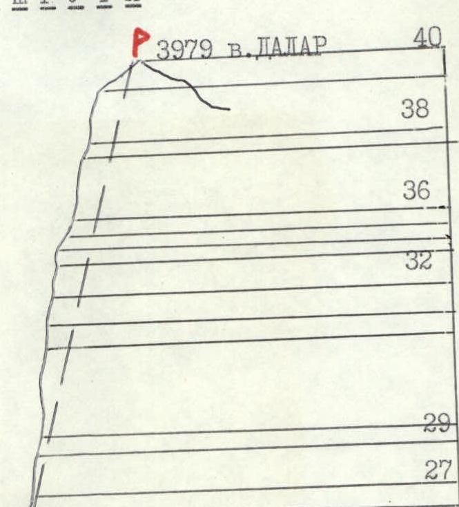
General photo of the summit
- Snesarev's route, completed by the team.
Route profile
The average steepness of the route profile is 75°.
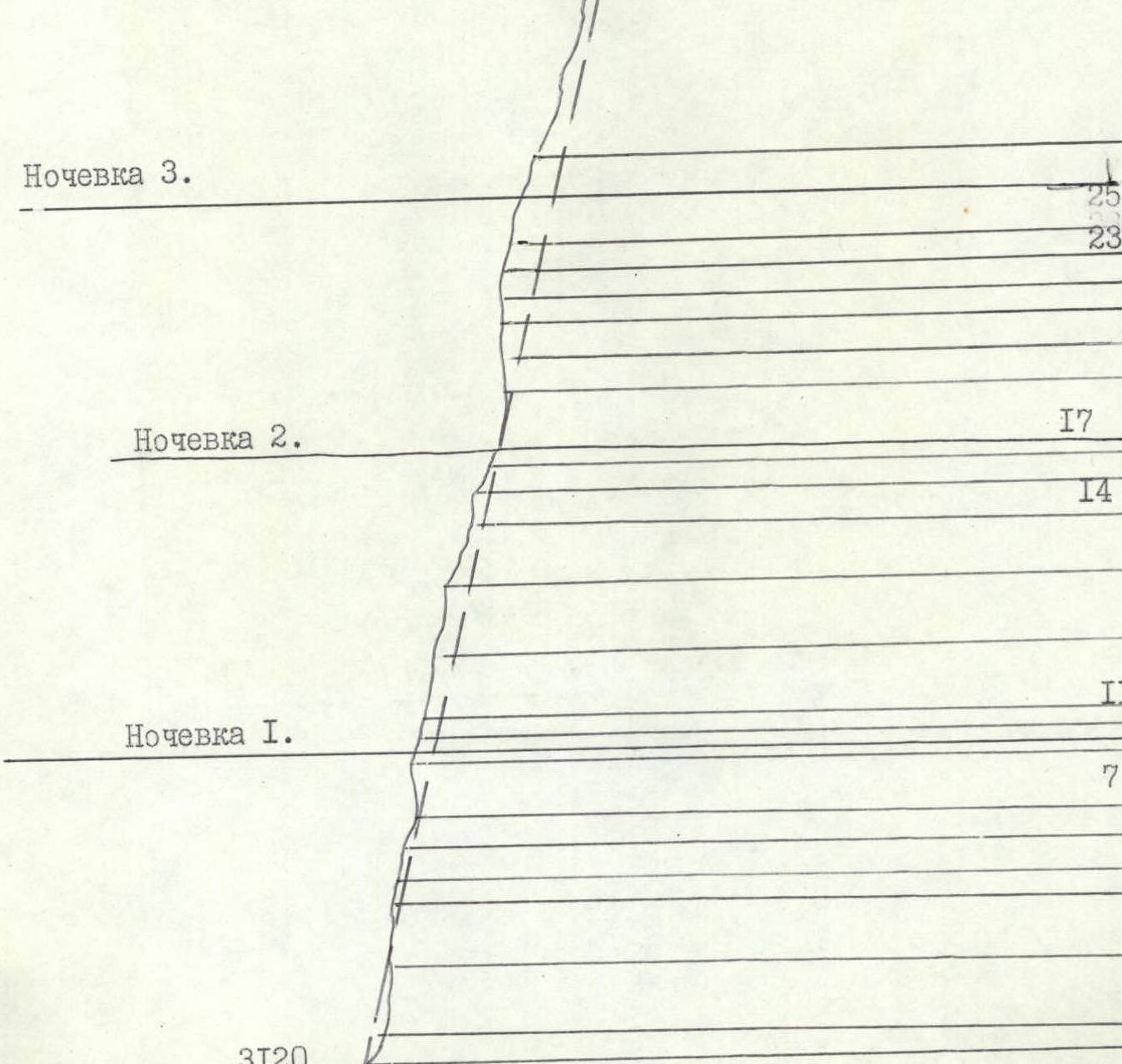
Overnight stop 3.
Preparation for the ascent
Snesarev's route on peak Dalar via the northern wall was chosen by the team for the following reasons:
- Only two teams had completed the route in 22 years since its first ascent.
- The route was entered into the USSR championship in 1983.
- To test the team's preparation level and capabilities on rock routes of greater steepness and length.
Before heading to the RSFSR championship in rock climbing, all team members participated in competitions on rock climbing and rescue operations in the Perm and Sverdlovsk regions.
Before starting the route entered into the championship, the team members completed several ascents of Category 4–5 difficulty in the same area.
- M.A. Selivanov, L.N. Selivanova, V.K. Stupalov — Sogrin's route, Category 5A, peak Kirpich, in challenging weather conditions.
- A.G. Nabokikh — peak Zamok via the north ridge, Category 5A.
- M.A. Selivanov, L.N. Selivanova — peak Kirpich, Category 5B, Ruzhevsky's route.
This allowed the team to better understand the area's characteristics, the structure of the rock relief, and the nature of the peaks, as well as the descent from peak Dalar (ascent via Category 4B, traverse of peak Shokoladny-Dalar).
In preparation for the ascent, the team conducted joint training sessions with B.L. Koshevnok's group (Safety Commission of the Alpine Federation of the USSR) on the training rocks at the "Uzunkol" alpine camp. They practiced belay techniques in case of a fall on complex rock terrain, tested new clamp and descender designs, and safety braking systems. The group simulated emergency situations.
Having carefully studied Snesarev's and Turkevich's reports, and by observing the route, the team planned to bypass the section R25–R26 on the left in case of bad weather, as it is the most hazardous due to falling rocks, as described in Turkevich's report.
To ensure safety, the team used new and high-quality equipment: 10 mm and 12 mm ropes, titanium pitons, extension slings, and chocks. All equipment was thoroughly tested. Anticipating unstable weather and water flows on the route, the team prepared polyethylene capes. Several rest days were planned before the ascent.
Tactical actions of the team
According to the competition regulations, preliminary route processing was not allowed.
On June 16 at 7:00 AM, the team started moving along the route. The lead climber used a double rope and wore caloshes. The lead was rotated every 3–4 rope lengths.
Mostly, belaying was done through pitons. Team members moved along fixed ropes with backpacks; on sections R3, R20, R21, the backpacks were pulled up. The average weight of the backpacks was about 10 kg. The lead climber went without a backpack. In the second half of the day, the weather steadily deteriorated throughout the route: sleet or rain. The temperature dropped sharply.
Within 4 hours, due to water flows on the route, the rope became significantly heavier and much harder to pass through carabiners, despite the use of extensions. The polyethylene capes provided little help as water poured in through the sleeves. The lead climber's progress slowed, and pitons had to be driven more frequently.
It became difficult and dangerous for the lead to pull up the 40-meter rope. They had to go 30 meters at a time. The lead was belayed using a "Sticht" belay device.
On section R5–R6, a thunderstorm hit, bringing heavy rain with hail. The weather forced the team to wait for 2 hours. The capes proved useful here as the group huddled in mini-tents.
On section R9, they set up a bivouac and spent the night. The overnight stay in a semi-reclined position in a tent was satisfactory.
July 17, 1984.
- Morning radio communication indicated that no improvement in the weather was expected.
- The team started moving at 7:00 AM.
- They continued along the route, having processed the previous day's rope.
On section R11–R12 — an internal corner, wall. Water was flowing abundantly, the rocks were slimy, and free climbing was impossible. The lead climber proceeded with caution. The further path to the summit of the "finger" went through wet, slippery rocks.
The weather worsened, clouds gathered, and visibility reduced to 30–50 meters. Fog disrupted communication between the climbers. An overnight stay was planned on the "finger" at section R17 due to a massive wall ahead, stretching up to 400 meters.
The summit of the "finger" turned out to be a sharp ridge. The team had to clear a large amount of snow and level a platform for the tent using rocks on the slope of the ridge. It took 3 hours to prepare, but they managed to set up a comfortable lying-down bivouac.
In the remaining daylight:
- They processed two rope lengths.
Thick snow started falling, followed by another thunderstorm. The timely set-up tent proved to be a lifesaver. The night passed without incident, although the sound of falling rocks was heard from time to time.
July 18, 1984.
- Started moving at 6:30 AM.
- The wall was firing rocks; they proceeded with maximum caution along the fixed ropes.
- Then, again, water on the wall, slippery rocks; the lead went with caution.
On section R24, as Turkevich had warned in his report:
- Many fallen rocks.
- Rocks were coming down the internal corner.
- It was dangerous to move.
The weather deteriorated. They set up a bivouac under the protection of an overhanging wall.
The pair Selivanov-Selivanova moved left to process the wall:
- The wall was clean and safe from falling rocks.
- The exit to the snowy belt was visible.
- They processed two rope lengths.
And again, as if on schedule, a thunderstorm hit. A squally wind struck the mountain, but the well-placed tent under the overhanging wall allowed for a relatively safe overnight stay.
The sound of falling rocks was heard from the couloir, confirming Turkevich's report.
July 19, 1984.
- Started moving at 6:30 AM.
- After the night's thunderstorm, the rocks were wet, местами covered with ice.
- With the help of fixed ropes, they climbed upwards.
The further ascent to the summit alternated between snow and rock.
- The snow was hard, requiring step-kicking.
- Belaying was done through an ice axe.
They reached the summit in fog, but since they had previously traversed the descent route, they safely descended under the southern walls of "Dalar" despite the rain that started.
Throughout the route:
- Team members were always connected by two ropes.
- Movement along the fixed ropes was done with top-rope belay only.
- The fixed rope was secured at 3–4 points.
- When passing rockfall-prone sections, the lead climber was belayed through a "Sticht" device.
- Team members took cover under natural wall shelters during such sections.
- A support group remained under the route, visually monitoring the climbers and maintaining radio contact according to the area's KSP schedule.
- Not a single radio communication session was missed during the ascent.
The team adhered to the planned overnight stays as per the tactical plan, given the weather conditions and the state of the route. There were no deviations from the route. Total climbing hours — 40.

Route diagram in UIAA symbols
Total climbing hours — 40
| Section # | Rock pitons | Bolted pitons | Ice pitons | Chocks "Friend" | Difficulty category | Length (m) | Steepness (°) |
|---|---|---|---|---|---|---|---|
| 0 | 0 | 0 | 0 | 0 | 4 | 15 | 65 |
| 1 | 0 | 0 | 0 | 0 | 3 | 15 | 50 |
| 2 | 0 | 0 | 1 | 0 | 5 | 40 | 80 |
| 3 | 0 | 1 | 0 | 0 | 6 | 35 | 90 |
| 4 | 0 | 1 | 0 | 0 | 6 | 15 | 90 |
| 5 | 0 | 0 | 0 | 0 | 5 | 20 | 90 |
| 6 | 2 | 0 | 0 | 0 | 4 | 20 | 65 |
| 7 | 0 | 0 | 0 | 0 | 6 | 40 | 90 |
| 8 | 0 | 0 | 0 | 0 | 4 | 10 | 65 |
| 9 | 0 | 0 | 0 | 0 | 5 | 10 | 75 |
| 10 | 0 | 1 | 0 | 0 | 4 | 15 | 65 |
| 11 | 0 | 0 | 0 | 0 | 6 | 40 | 80 |
| 12 | 0 | 0 | 0 | 0 | 6 | 40 | 75 |
| 13 | 0 | 0 | 0 | 0 | 5 | 35 | 70 |
| 14 | 2 | 0 | 0 | 0 | 5 | 20 | 75 |
| 15 | 1 | 0 | 0 | 0 | 5 | 15 | 75 |
| 16 | 0 | 0 | 0 | 0 | 3 | 10 | 45 |
| 17 | 0 | 0 | 0 | 0 | 5 | 40 | 80 |
| 18 | 0 | 0 | 0 | 0 | 6 | 20 | 95 |
| 19 | 4 | 0 | 0 | 0 | 6 | 20 | 90 |
| 20 | 0 | 0 | 0 | 0 | 5 | 15 | 85 |
| 21 | 0 | 0 | 0 | 0 | 6 | 15 | 85 |
| 22 | 0 | 0 | 0 | 0 | 5 | 15 | 80 |
| 23 | 0 | 0 | 0 | 0 | 5 | 25 | 75 |
| 24 | 0 | 0 | 0 | 0 | 5 | 30 | 65 |
| 25 | 0 | 0 | 0 | 0 | 6 | 20 | 95 |
| 26 | 0 | 1 | 0 | 0 | 4 | 10 | 60 |
| 27 | 0 | 0 | 0 | 0 | 4 | 30 | 60 |
| 28 | 0 | 0 | 0 | 0 | 5 | 60 | 50 |
| 29 | 0 | 0 | 0 | 0 | 4 | 28 | 60 |
| 30 | 0 | 0 | 0 | 0 | 5 | 30 | 80 |
| 31 | 0 | 0 | 0 | 0 | 5 | 10 | 70 |
| 32 | 1 | 0 | 0 | 0 | 5 | 75 | 60 |
| 33 | 1 | 0 | 0 | 0 | 6 | 20 | 50 |
| 34 | 1 | 0 | 0 | 0 | 4 | 20 | 50 |
| 35 | 0 | 0 | 0 | 0 | 6 | 20 | 85 |
| 36 | 0 | 0 | 0 | 0 | 5 | 25 | 75 |
| 37 | 5 | 2 | 0 | 0 | 5 | 8 | 90 |
| 38 | 6 | 0 | 2 | 0 | 4 | 10 | 65 |
| 39 | 15 | 0 | 0 | 1 | 5 | 15 | 65 |
| 40 | 8 | 0 | 0 | 1 | 5 | 45 | 80 |
| 41 | 10 | 0 | 0 | 0 | 4 | 7 | 70 |
| 42 | 4 | 2 | 0 | 1 | 5 | 40 | 80 |
| 43 | 0 | 0 | 0 | 0 | 3 | 40 | 30 |
Route description by sections
Section R0–R3: Bergrschrund, bypassed on the left of the rock island. The lower part and the approach to the route should be done early in the morning: there is a risk of avalanches and rocks falling from the large couloir on the right, which was observed during the team's movement along the route.
Section R3–R4: Wet, heavily fragmented internal corner. Challenging climbing.
Section R4–R9: Lots of water. Convenient belay points. Slippery rocks.
Section R9 — overnight stay in a semi-reclined position in a tent under the protection of the wall.
Section R9–R17: Slabs, internal corners, monolithic rocks. There are platforms for bivouac.
Section R17 — overnight stay on the summit of the "finger" — lying down.
Section R17–R25: starts with heavily fragmented rocks; climbing is extremely cautious and challenging. One previously driven bolted piton was encountered.
Section R25–R30: Monolithic rocks, pleasant climbing. Slots allow for the use of various pitons and chocks.
Section R30–R42: Small vertical walls alternate with snowy ledges. Requires heightened attention, reliable belaying, and many loose rocks.
Section R42–R47: The summit tower consists of vertical internal corners. Monolith, large blocks. Convenient belay points. The exit to the summit is via simple rocks.
The descent is straightforward: down the southern slope of peak "Dalar" to the saddle between "Dvoynashka" and "Dalar".


