71
1983 USSR Alpine Climbing Championship
Rock climbing category
Report
Report on the ascent of Dalar peak (3979 m): second ascent of Snesarev's route on the north face.
Team of the Ukrainian Sports Committee.
Leader: Turkevich M.M. Senior coach: Sivtsov B.G. Coach: Spesivtsev A.E.
Addresses:
- 340003 Donetsk, Illicha Ave. 91, alpcamp “Donbass”, ph. 90-17-90.
- 340003 Donetsk, Captain Ratnikov st. 18, apt. 12, ph. 95-01-55. Turkevich Mikhail Mikhailovich
- 340003 Donetsk, Captain Ratnikov st. 18, apt. 94, ph. 95-89-46. Sivtsov Boris Grigorievich.
Elevations in the report were determined by:
- Peak elevations were taken from the catalog "Classification table of routes to mountain peaks of the USSR";
- Section elevations were determined on-site visually and based on data from the USSR Sports Committee group, which determined elevations in the area using a theodolite.

Photo of the face profile on the right. 1976, "Zorki" camera.
Preparation for the ascent
Snesarev's route on Dalar peak via the north face was chosen by the team for the following reasons:
- For more than twenty years, it had not been repeated, although attempts were made.
- The route is well-defined on the face, logical.
- Significant length and north orientation.
- Rock sections of the route are very steep.
Before heading to the USSR Alpine Climbing Championship in the rock climbing category, all team members participated in a winter training camp in the Caucasus, and in the spring, they took part in several rock climbing competitions in Crimea. Before starting the routes entered for the championship, they completed several ascents of 4th-5th difficulty category in the same area. This helped to better understand the area's characteristics, particularly the structure of the mountains and the nature of the peaks, as almost all participants were climbing in this area for the first time. Vareikis V. and Belousov S. ascended Dalar via the northeast ridge, the beginning of which coincides with Snesarev's route. Before ascending Dalar, the team had already completed a route on Kirpich peak via the diamond-shaped west face, 5B difficulty category, as part of the championship.
Considering the potential presence of water flows and ice on the route, as well as unstable weather in the area, a tactical plan included an overnight stay under the summit tower.
The full team approached the route for visual observations and to assess the feasibility of processing the route in the evening. The primary plan was to ascend without an overnight stay, processing the lower part according to the championship conditions, which allowed processing no more than 100 m.
To ensure safety, the group used new and high-quality equipment:
- Ropes — 12 mm
- Pitons — titanium and VTSSPS
- Slings, extenders — nylon, etc.
Before the ascent, several days of rest were planned.
Ascent schedule
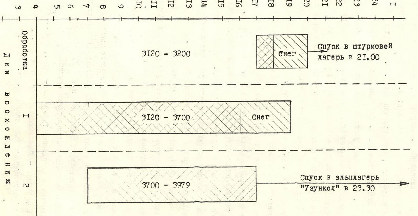
Tactical actions of the team
According to the tactical plan for ascending Dalar peak via Snesarev's route, the team planned preliminary processing of the route the day before the ascent. On July 2, Pilipenko, Vareikis, and Bondarenko went out for processing. Within two hours, they fixed a rope across the bergschrund and processed and fixed another two ropes. During this section, they encountered old pitons, and the rocks were wet. Observations during the processing confirmed the presence of water flows and waterfalls on the route.
On July 3 at 5:00, the team was at the base of the route. They passed the fixed ropes and continued with a change of lead every 2-3 ropes. Using 12 mm UIAA-certified ropes, the lead climber was belayed on a single rope. Belaying was done through a "Sticht" plate. Pitons were hammered, and chocks and spring-loaded camming devices ("friends") were used for belaying. Chocks and "friends" allowed for reduced time spent on organizing belays. Nylon slings were used for better rope management. Other team members moved along the fixed ropes with backpacks. Rucksack hauling was not used, as the average backpack weight was 7-8 kg. The lead climber went without a backpack. Due to water flows on the wall, ropes and clothing got immediately wet, doubling the rope weight and making it harder to pull through carabiners. The condition of the route worsened due to the abundance of water and ice.
In the afternoon, the weather deteriorated, with a thunderstorm and hail. At that moment, the team was exiting the wall towards the bastion. Waterfalls of snow gravel prevented further movement for about an hour. A bivouac was set up on section R4. A cave was dug for this purpose, where the team spent the night. The further path from the bivouac to the summit went through icy rocks and, in places, ice. These sections were traversed in crampons, with belaying through ice screws. Throughout the route, ropes were fixed at two to three anchor points. Communication with observers was stable, and no radio sessions were missed.
The team followed the planned tactical plan, including an overnight stay at the designated location. The entire route was traversed in Vibram boots; rock shoes were not used due to the poor condition of the route.
Pitons used:
- Rock — 132/20
- Bolt — 2, used from previous groups
- Ice — 12
- Chocks — 99/3
- "Friends" — 22
Total climbing hours — 27 h 00 min.
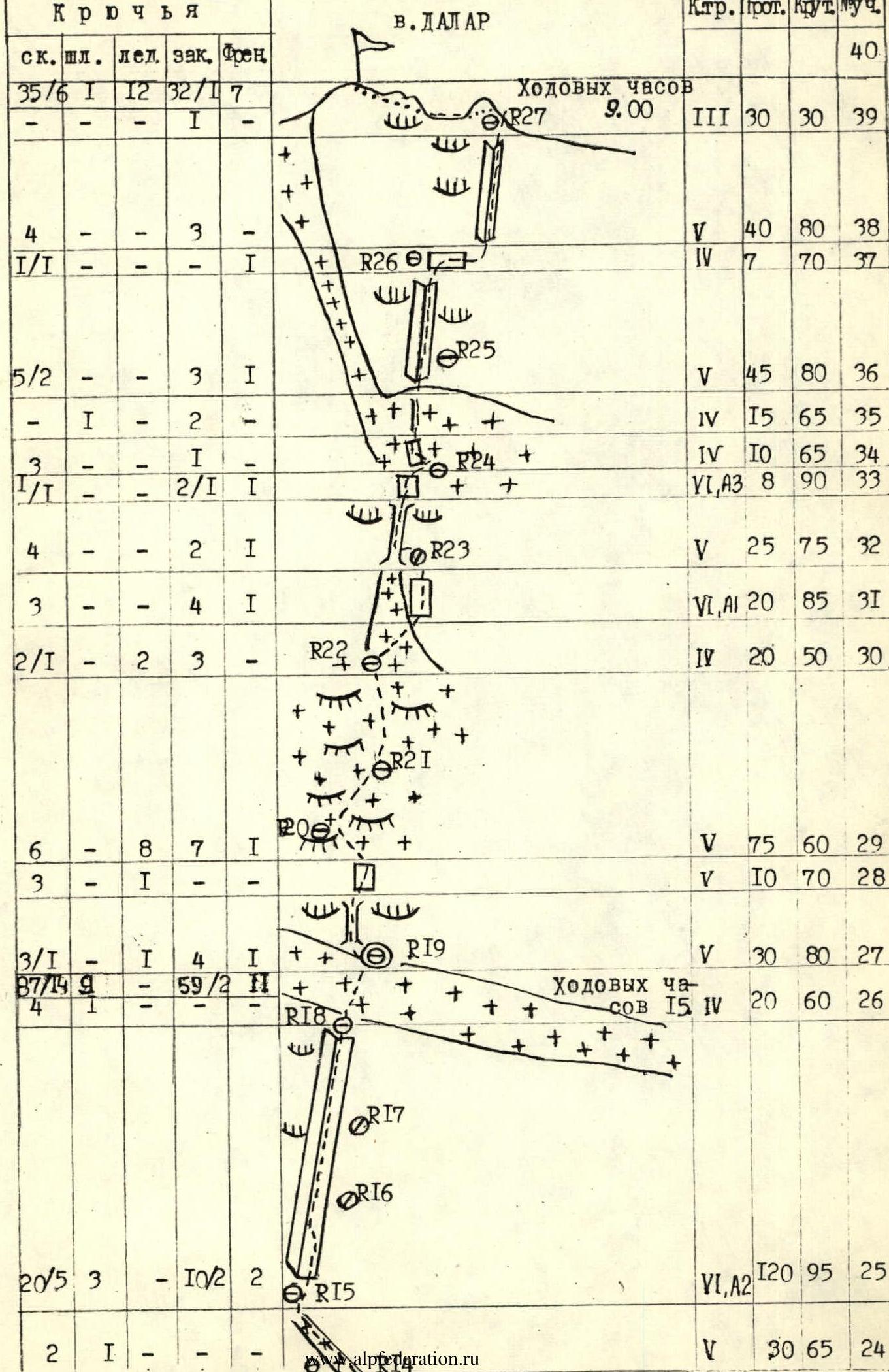
Route diagram in UIAA symbols
| Rock | Bolt | Ice | Chock | Friend | Control | Prot. | Steep | Sect. |
|---|---|---|---|---|---|---|---|---|
| 35/6 | 1 | 12 | 32/17 | — | 40 | |||
| — | — | 1 | — | — | 3 | 30 m | 30 | 39 |
| 4 | — | — | 3 | — | 5 | 40 m | 80 | 38 |
| 1/1 | — | — | — | 1 | 4 | 7 m | 70 | 37 |
| 5/2 | — | — | 3 | 1 | 5 | 45 m | 80 | 36 |
| — | 1 | — | 2 | — | 4 | 15 m | 65 | 35 |
| 3 | — | — | 2/1 | 1 | 4 | 10 m | 65 | 34 |
| 4 | — | — | 2 | 1 | 6, A3 | 8 m | 90 | 33 |
| 3 | — | — | 4 | 1 | 5 | 25 m | 75 | 32 |
| 2/1 | — | 2 | 3 | — | 6, A1 | 20 m | 85 | 31 |
| 6 | — | 8 | 7 | 1 | 4 | 20 m | 50 | 30 |
| 3 | — | 1 | — | — | 5 | 75 m | 60 | 29 |
| 3/1 | — | 1 | 4 | 1 | 5 | 10 m | 70 | 28 |
| 8/1 | — | 4 | 5/2 | 1 | 5 | 30 m | 80 | 27 |
| 20/5 | — | 3 | 10/2 | 2 | 4 | 20 m | 60 | 26 |
| 2 | 1 | — | — | — | 6, A2 | 120 m | 95 | 25 |
| 2 | — | — | — | 1 | 5 | 30 m | 65 | 24 |
| 2 | — | — | 4 | — | 5 | 25 m | 75 | 23 |
| 2 | — | — | 3 | — | 5 | 15 m | 80 | 22 |
| 3/1 | — | — | 2 | — | 6, A1 | 15 m | 85 | 21 |
| 4 | — | — | 2 | — | 5 | 15 m | 85 | 20 |
| 4 | — | — | 6 | 2 | 6 | 20 m | 90 | 19 |
| 6/2 | — | — | 1 | — | 6, A1 | 20 m | 95 | 18 |
| 4/1 | — | — | 2 | — | 5 | 40 m | 80 | 17 |
| 2 | — | — | 1 | — | 3 | 10 m | 45 | 16 |
| 2 | — | — | 1 | — | 5 | 15 m | 75 | 15 |
| 3/1 | — | — | 2 | 1 | 5 | 20 m | 75 | 14 |
| 3 | — | — | 4 | 1 | 5 | 35 m | 70 | 13 |
| 4/1 | — | — | 4 | — | 6, A1 | 40 m | 75 | 12 |
| 4/2 | — | — | 8 | 1 | 6, A1 | 40 m | 80 | 11 |
| — | 1 | — | 1 | — | 4 | 15 m | 65 | 10 |
| 2 | — | — | — | 1 | 5 | 10 m | 75 | 9 |
| 2 | 2 | — | — | — | 4 | 10 m | 65 | 8 |
| 4/1 | — | — | 4 | 2 | 6, A1 | 40 m | 90 | 7 |
| 2 | — | — | 3 | — | 4 | 20 m | 65 | 6 |
| 3 | — | — | 2 | 1 | 5 | 20 m | 80 | 5 |
| 5 | — | — | 1 | — | 6 | 15 m | 90 | 4 |
| 10/2 | 1 | — | 8 | 3 | 6, A1 | 35 m | 90 | 3 |
| 5 | — | — | 3 | — | 5 | 40 m | 80 | 2 |
| 4/2 | — | — | 3 | 1 | 3 | 15 m | 50 | 1 |
| — | — | — | 1 | 1 | 4 | 15 m | 65 | 0 |
| 1 | 1 | — | 1 | 1 |
Route description by sections
Section R0-R4: processed on July 3, 1983, in the afternoon. Processing aimed to confirm the route's starting point and assess its condition. Fixed ropes were left in place. The bergschrund is traversed along a rock island without significant difficulties. In the morning, there is ice on this section. The lower part of the route should be traversed quickly to avoid falling rocks.
Section R4-R5: wet and heavily fractured internal corner; possible rockfall hazard to lower climbers.
Section R5-R11: abundant water, ice in cracks, and snow-covered ledges during the ascent. There are convenient belay stances.
Section R11-R17: pleasant climbing on slabs along internal corners filled with snow. The rock is monolithic. At the end of the section, Snesarev's and Shopin's routes converge (as indicated by pitons). There are suitable areas for a bivouac.
Section R17-R25: begins with heavily fractured rock. Climbing is cautious and challenging. Some bolt pitons are encountered.
Section R25-R26: overhanging internal corner, weakened by moisture. Movement is possible along the corner and rightward on slabs. Many good crack placements for chocks. The upper part has very soft rock (dolomite), requiring long pitons for belaying.
At the end of this section, there's an exit onto a roof via a couloir, which is hazardous during bad weather due to falling rocks and gravel; this section should be traversed quickly.
Under the overhanging rock, there's a convenient bivouac site on a wide snowy ledge.
Section R26-R38: vertical small walls alternating with ice and snow sections. Ice screws were used here, and the lead climber wore crampons. The section is relatively straightforward but demands significant attention to belaying.
Section R38-R39: the pre-summit bastion. A system of steep internal corners. Pleasant climbing on dry rock. The upper part has a section of heavily fractured rock. There are convenient belay stances and many crack placements for chocks. The summit is reached via simple rock.
Throughout the route, the lead climber used a single 12 mm "Schuster" rope. Others moved on fixed ropes. The lead changed every 2-3 ropes.
At belay stances:
- Ropes were fixed at a minimum of two points.
- Belays were interconnected.
- Rucksacks were not hauled.
- The lead climber carried a light backpack.
Belaying of the lead climber was done through a "Sticht" plate. Rock shoes were not worn due to the poor condition of the route.
The entire route, up to the roof exit, was very wet, likely due to poor weather conditions in the area at the time. A team of 2-4 people can realistically complete the route in one day if its condition is good.
In case of prolonged bad weather, it is possible to deviate left from this route to a simpler route — Stepanov's route.


