Passport
- Rock class.
- Western Caucasus, Uzukol region.
- Peak "Dalar", center of the northern wall of the bastion.
- Proposed - 6B category of difficulty, first ascent.
- Height difference: 1200 m, length - 1825 m (1935 m).
Length of sections with 5-6 category of difficulty - 695 m. Average steepness of the main sections 85° (2900-3560 m): including sections with 6 category of difficulty - 415 m (2900-3080 m, 3110-3170 m, 3245-3270 m, 3300-3350 m, 3420-3525 m); 87° (2900-3080 m, 3300-3350 m, 3420-3525 m); 90° (3110-3170 m); 92° (3245-3270 m).
- Pitons hammered:
| rock | bolt | chocks | ice |
|---|---|---|---|
| 228 | 10 | 41 | 0 |
| 44 | 10 | 11 | 0 |
- Team's working hours: 62 hours and 7 days.
- Overnights:
- 1st-2nd platform cut out on a snowy slope;
- 3rd - two people in hammocks, four separately on shelves;
- 4th-5th - separately on shelves;
- 6th - on a rock platform for 6 people.
- Leader: Alexey Sergeyevich Ivashchenko, Candidate Master of Sports
Team members:
- Yuri Borisovich Meshkov, Candidate Master of Sports
- Yuri Dmitriyevich Retyunsky, Master of Sports
- Vitaly Pavlovich Stukhin, Candidate Master of Sports
- Nikolai Vasilyevich Sulimovsky, Candidate Master of Sports
- Vladimir Ivanovich Shchukin, Master of Sports
- Coach: Yuri Dmitriyevich Retyunsky
- Departure on the route: July 8, 1982.
Summit: July 14, 1982.
Return: July 14, 1982.
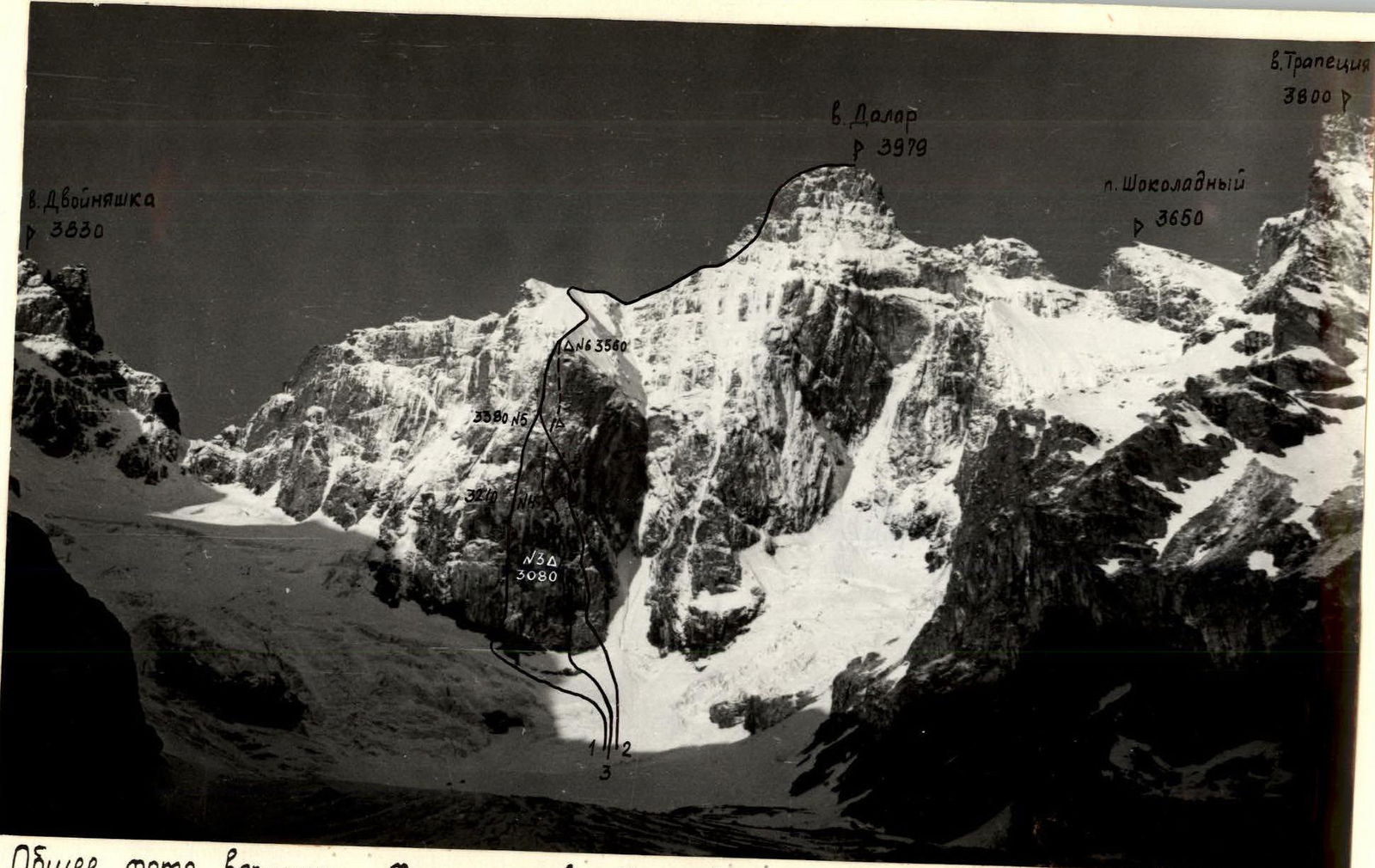
General photo of the summit. Photo taken from the "Karman" overnight stay (2700 m), July 8, 1982. Distance - 2.5 km. T22 (40 mm).
1 - B. Korablin's route; 2 - "Druzhba" route; 3 - team's route.
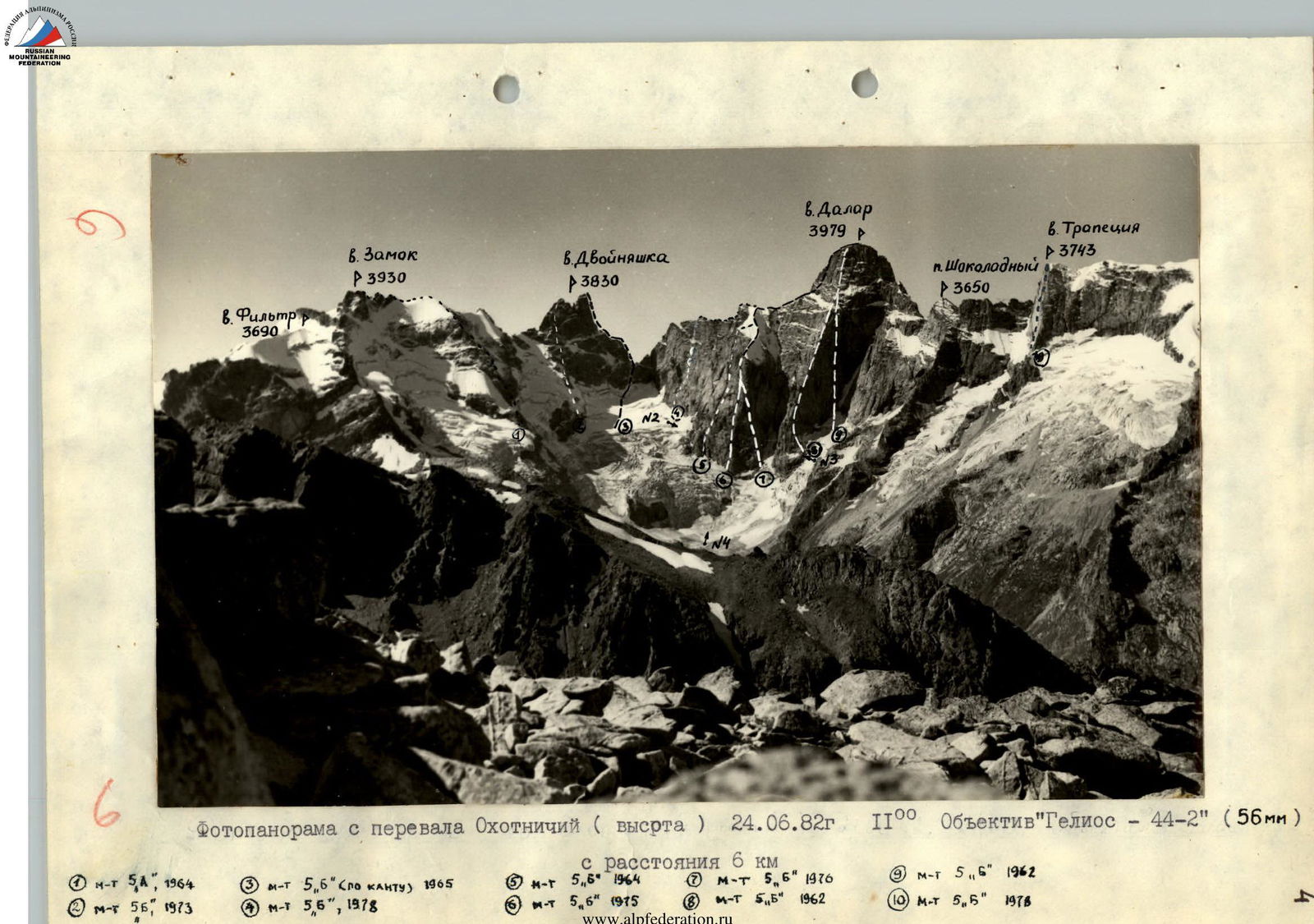
Photopanorama from Ohotnichiy pass (height), June 24, 1982, 11:00. "Helios-44-2" lens (56 mm), from a distance of 6 km.
- 5A category route, 1964;
- 5B category route, 1973;
- 6 category route (along the edge), 1965;
- 6 category route, 1978;
- 6 category route, 1964;
- 6 category route, 1975;
- 6 category route, 1976;
- 5 category route, 1962;
- 6 category route, 1962;
- 5 category route, 1978.
Tactical actions of the team
As expected, the most difficult part of the ascent was the passage of the northern wall of the bastion. Given the wall's great steepness and the fact that its passage would require significant physical and moral strength, a change of lead and last climber was planned for the second half of the day to maintain a high pace.
Due to the limited number of overnight stays on the wall, great attention was paid to:
- route preparation;
- subsequent descent to the overnight stay.
The team, having experience in climbing routes prone to rockfall in the Fann Mountains (peak "Maria"), used the principle of maximum safety when organizing belay stations. Mainly, these were locations under cornices, overhangs, and as far as possible from the direction of movement of the preceding participants. All ropes were secured with high reliability; when organizing them, a blockage of 2-3 pitons was used. The movement of participants was built on the following system: the first climbed on a double rope (one of which was necessarily 11 mm in diameter); the second climbed on a fixed rope with top belay, carrying two ropes and the maximum amount of free equipment; the third moved on two fixed ropes; the fifth and sixth climbed with top belay. (The fourth also climbed with top belay). This allowed the first to move without stopping. The first always climbed without a backpack. The rest of the participants climbed with backpacks without pulling them out. For this, the team took n+1 ropes on the route (where n is the number of participants). This movement scheme was tested by the team on joint ascents in the 1976-1981 seasons and ensures maximum safety during wall climbs. All participants moved on ropes with two ascenders, using the "chest-leg" system; the third additionally secured himself with a prusik knot on the second rope. On previously hung ropes, the first always climbed with bottom belay. Given the small number of overnight stays, all participants took hammocks on the route. They started determining the overnight stay location from 14:00. There were no falls or injuries on the route. The main criterion for choosing overnight stays was safety. All overnight stays were organized in places protected from rockfall. Four team members participated in organizing overnight stays, while the other two continued route preparation. Preparation lasted until 20:00-21:00.
When passing problematic sections of the route, the team used "skyhooks" for the first time. Their application exceeded our expectations. The speed of passing steep, smooth walls without cracks was twice as fast as when using conventional means ("bolt pitons"). It's a pity that the modern "skyhooks" variants, long ago conceived by Vitaly Abalakov (from the stories of the team's judge, V. M. Kopylov), had not found their application earlier.
In case of bad weather, team members took raincoats or polyethylene cloaks on the route. During rain, the team continued to move, and only a prolonged heavy rain on July 9 forced the team to descend to the previous overnight stay. Communication with observers was carried out using a "Vitalka" radio station according to a previously agreed schedule. In case of necessity, they agreed on additional communication. In case of radio station failure, rockets with a flare gun were taken on the route.
The team basically fulfilled the tactical plan. The only deviation from the tactical plan was the slow passage of the first section - the wall. Here, the structure of the rock relief let us down. The cracks that we saw during reconnaissance and through which we planned our path turned out to be dark veins in fine-grained granite, and therefore the path had to be laid through more complex rock relief. The preceding prolonged bad weather also complicated the route (constantly wet rocks). Streams constantly flowed from above from previously fallen snow. There were no problems with water. In good weather, this problem will arise for the next climbers because there is no water along the entire wall of the bastion. Not for nothing did the pair Grakovich - Warburton compare this wall to the El Capitan wall.
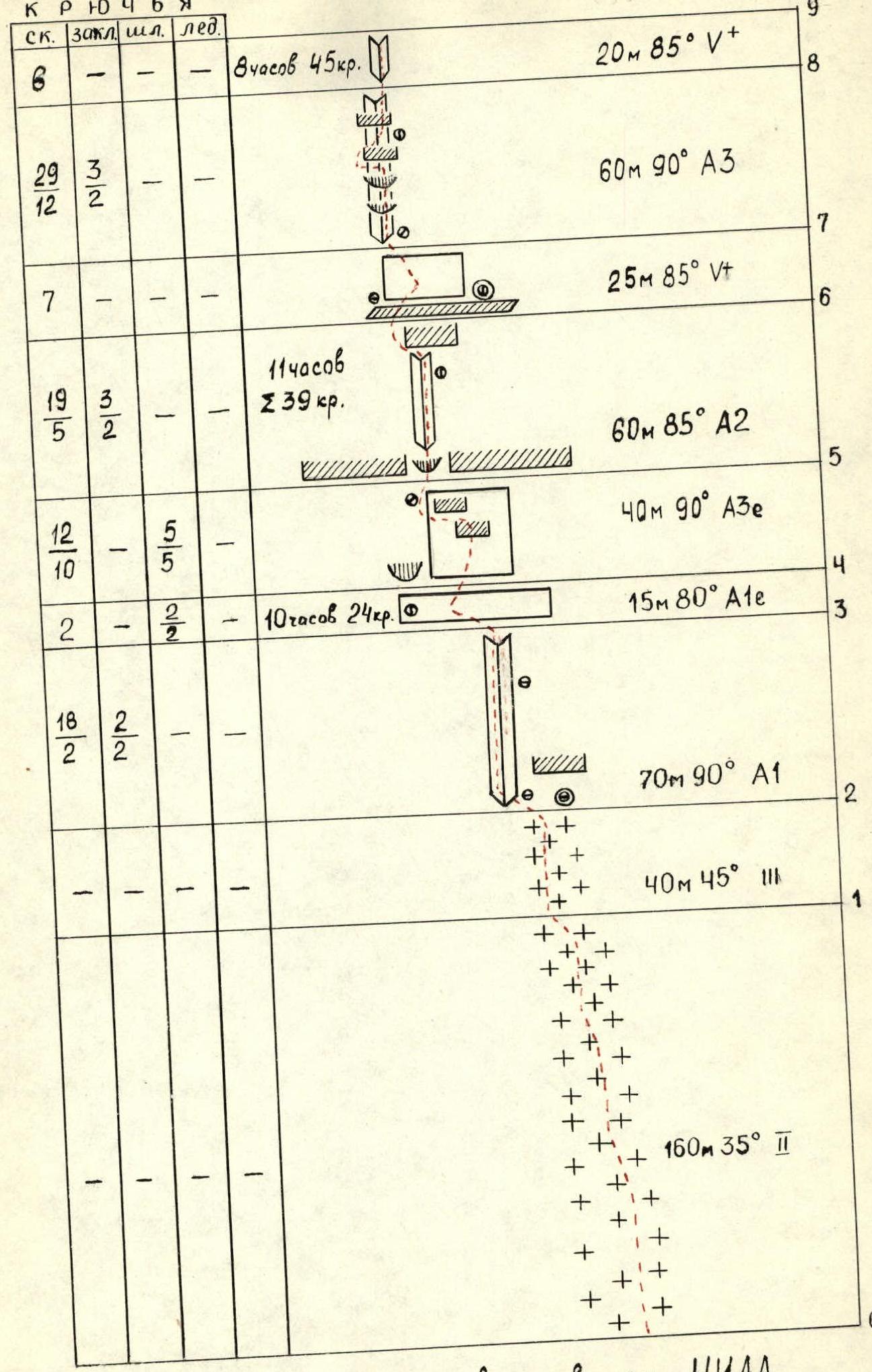
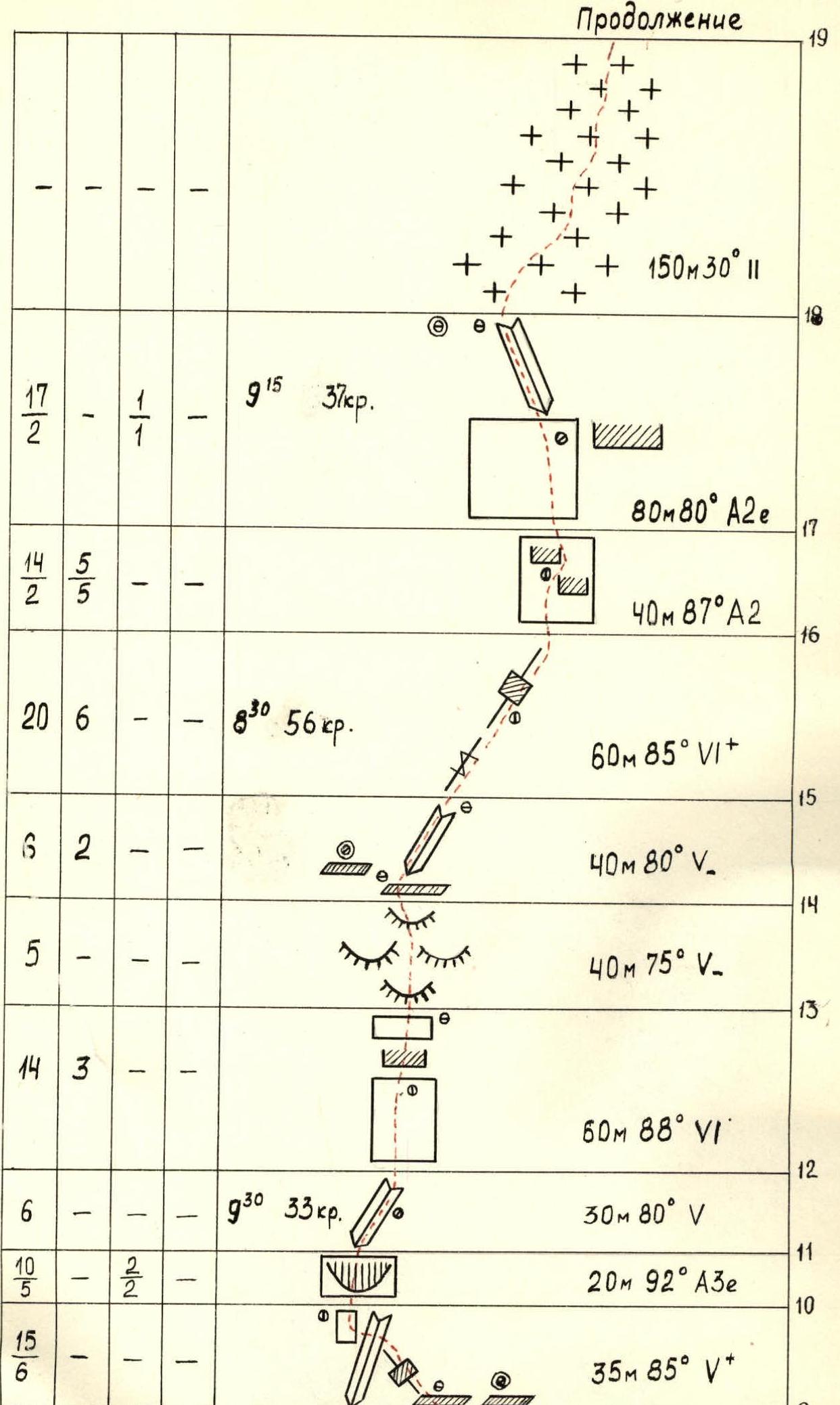
Route scheme in UIAA symbols.
Route description by sections
The approach to the route passes through the plateau of the Big Kichkinekol glacier. In the second half of summer, crevasses may open on the glacier. Therefore, its passage requires special attention, caution, and mandatory roping.
Section R0-R1. Snow slope 160 m, 35°. Does not present particular difficulties. Simultaneous movement. At the top, a bergschrund. Passed via a snow bridge with belay through an ice axe. In the second half of summer, snow bridges may be absent. Then the bergschrund is passed with descent and ascent along the ice wall using ice equipment. It is advisable to pass early in the morning, as rockfall is possible from the couloir separating the walls of the bastion and the Eastern ridge.
Section R1-R2. Steep snow slope (possibly ice!) 40 m, 45°. Approach to the wall in the area of a sheer inner corner, to the right of which is a large cornice. Under the cornice, after clearing the snow, a platform for an overnight stay can be organized.
Section R2-R3. Sheer inner corner 70 m, 90°. In the lower and upper parts of the corner, there are overhangs. Passed using artificial aids. Belay station on small ledges.
Section R3-R4. Smooth inclined slab with a limited number of holds and cracks. Use of bolt pitons is necessary 15 m, 80°. In the left part of the slab, under an overhang, a belay station.
Section R4-R5. Sheer wall with a small number of holds and cracks ("bolt pitons"!) 40 m, 90°. At the top of the wall, a series of small cornices. Rocks are destroyed. Maximum attention. Passage through a cornice and around the next cornice on the left. Belay station is very inconvenient.
Section R5-R6. Inner corner with a large cornice above 60 m, 85°. Entrance to the inner corner through destroyed overhangs. There are enough cracks and holds. The cornice is bypassed on the left along a sheer wall (using artificial aids). Control cairn. Exit to inclined ledges. Overnight stay is possible.
Section R6-R7. Wall 25 m, 85°. Along the wall first to the right 15 m, then to the left 10 m under the base of the inner corner. There are enough cracks and holds.
Section R7-R8. Sheer inner corner 60 m, 90°. Narrow cracks. Up the inner corner and through two overhangs, exit to a cornice. The cornice is bypassed on the left. Then again along the inner corner to the next cornice. The cornice is passed in the right part. There are no convenient places for belay stations. All belay stations are only on overhangs.
Section R8-R9. Implicitly expressed inner corner 20 m, 85°. Pleasant climbing. Sufficient number of holds and cracks. Exit to small ledges. Overnight stay is possible.
Section R9-R10. Wall with an oblique crack 35 m, 85°. Up the crack to the left to the inner corner (using artificial aids) and through the inner corner, approach under an overhanging wall. Belay station is very inconvenient.
Section R10-R11. Overhanging wall 20 m, 92°. Very complex climbing on artificial holds. Limited number of cracks and holds.
Section R11-R12. Inner corner 30 m, 80°. Pleasant climbing. Many cracks and holds. Control cairn.
Section R12-R13. Wall 60 m, 88°. Straight up the wall and through a cornice, exit to smoothed slopes overgrown with lichen.
Section R13-R14. Smoothed rocks like "ram's foreheads" 40 m, 75°. Many cracks. Control cairn of Grakovich's route. Overnight stay is possible.
Section R14-R15. Inner corner leading to the center of the bastion's tower, towards a light-brown overhanging wall 40 m, 80°.
Section R15-R16. Oblique crack 60 m, 85°. The light-brown wall is bypassed on the right. Climbing is very tense. There are no convenient belay stations. Control cairn.
Section R16-R17. Wall with two cornices 40 m, 87°. The first cornice is bypassed on the left (using artificial aids). Belay station is very inconvenient. Exit under a large cornice.
Section R17-R18. Slab ending with an inner corner with an overhang 80 m, 80°. The slab has a small number of holds and cracks ("bolt pitons"!). The cornice is bypassed on the left and along the inner corner, exit to the bastion.
Section R18-R19. Lower part of a U-shaped snow ascent 150 m, 30°. Simultaneous movement.
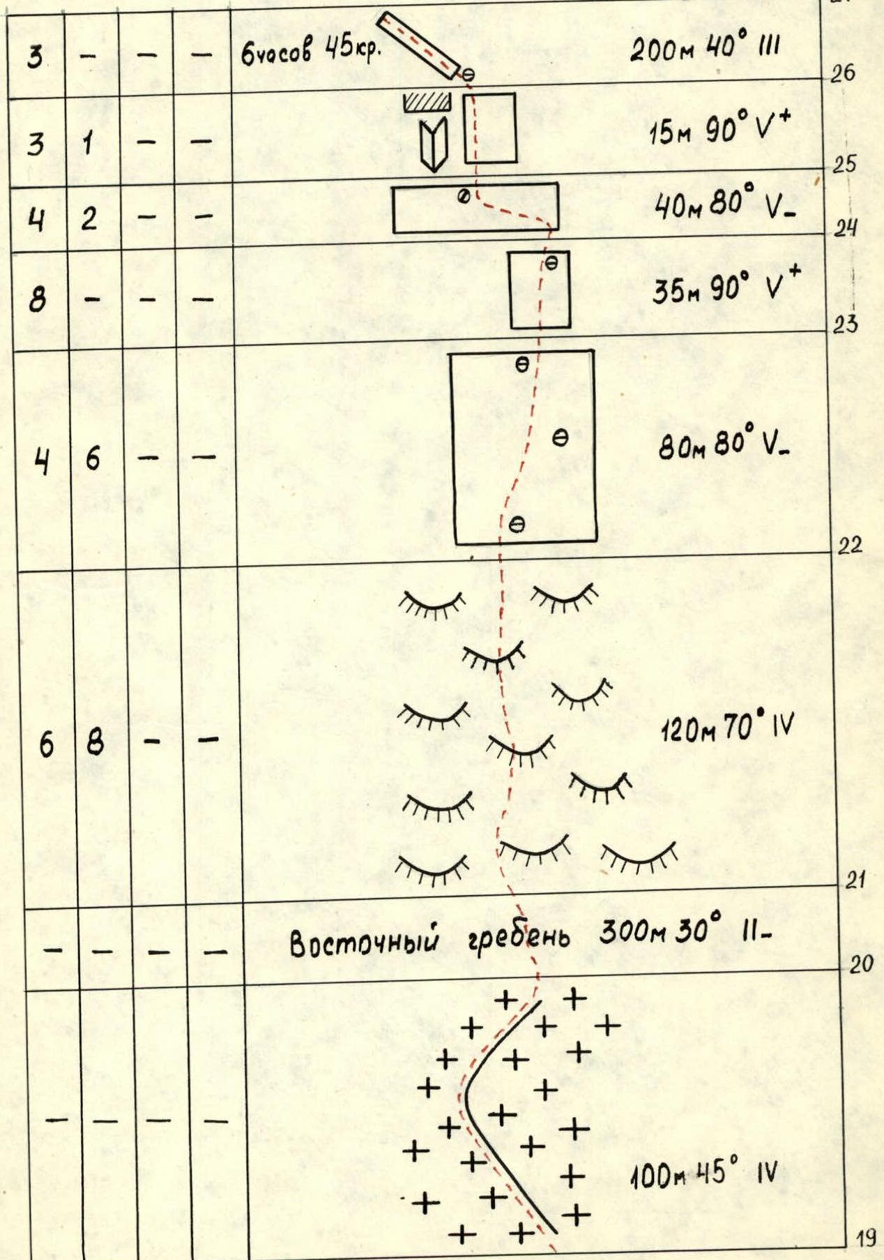
Section R19-R20. Upper part of a U-shaped snow ascent 100 m, 45°. Steepness reaches 50° in places. Alternating movement with belay through an ice axe. It is advisable to pass early in the morning on a crust. In good weather, ice may be exposed, then it is passed using ice equipment.
Section R20-R21. Eastern ridge. The simplest part of the route. Passed simultaneously 300 m, 30°.
Section R21-R22. Rocks like "ram's foreheads". Many cracks and holds. 120 m, 70°. Alternating movement.
Section R22-R23. Smoothed rocks with a sufficient number of holds and cracks 80 m, 80°. Pleasant climbing. Exit again to the Eastern ridge. Control cairn. There is a place for an overnight stay.
Section R23-R24. Sheer wall 35 m, 90°. Limited number of cracks and holds. Passed with free climbing. At the top of the wall, a good place for a belay station.
Section R24-R25. Traverse to the left with a small gain in height along a wall with smoothed relief. 40 m, 80°. Exit to an inner corner at the top with a large cornice.
Section R25-R26. Right wall of the inner corner 15 m, 90°. Bypass of the cornice. There are enough cracks and holds.
Section R26-R27. Inclined ledge leading to the summit 200 m, 40°, alternating with rocks up to 60° steep.
Descent from the summit along the 3B category route to the south.


