Ascent Passport
I. Rock climbing category 2. Caucasus. From Nakhar pass to Chipperazau pass. 3. Dalar peak (3979 m) via the North-Eastern wall of the Eastern shoulder. 4. Difficulty category - 5B (third ascent of the route) 5. Route characteristics: height difference R0–R15 - 700 m, length of sections with 5-6 difficulty category - 610 m, including 400 m on the shoulder wall R0–R12, average steepness of the shoulder wall R0–R12 - 81°. 6. Pitons hammered: for rock protection (including chocks) 99(35), for creating artificial support points 10(4), ice screws (on descent) - (4), bolt pitons - - 7. Total climbing hours - 23 hours 8. Number of bivouacs and their characteristics: two good bivouacs in a tent. 9. Climbing leader: Severnyuk Alexander Petrovich, 1st sports category.
Team members:
- Zagirnyak Mikhail Vasilyevich, Candidate Master of Sports, instructor
- Silenko Alexey Leonidovich, 1st sports category
- Sorokin Nikolai Evgenievich, Candidate Master of Sports Team coaches: Zakharov Pavel Pavlovich Krasnoshchekov Nikolai Alekseyevich
- Date of departure on the route - August 1, 1981
- Date of return - August 5, 1981
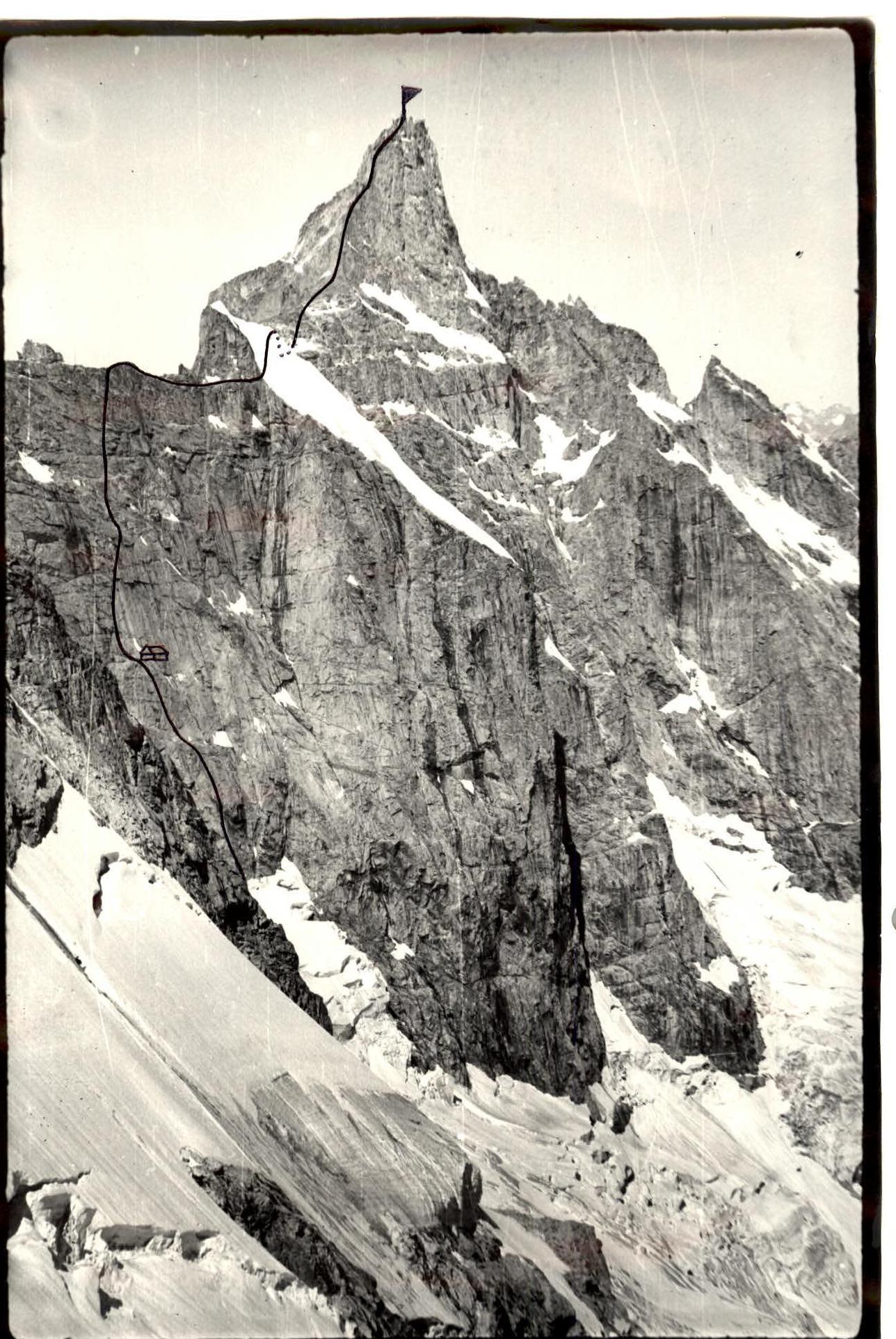
Table of main characteristics of the route to Dalar peak via the NE wall of the Eastern shoulder 5B cat. sl. (third ascent of Yu. Porokhnya's route)
| Date | Sections traversed | Average steepness | Length along the route | Characteristics of sections and conditions of their passage by terrain | Technical difficulty | Insurance method | Exit time | End time | Total climbing hours | Rock pitons hammered | Bolt pitons hammered | Ice pitons hammered | Bivouac conditions |
|---|---|---|---|---|---|---|---|---|---|---|---|---|---|
| August 8, 1984 | R0–R1 | 85° | 40 m | wide internal corner | tense climbing, few holds, 5B cat. sl. | pitons, ladder use | 6:30 from bivouac | 14:00 on wall | Passage of icefall 4.5 hours | 8/I | - | - | Bivouac on a ledge |
| R1–R2 | 85–90° | 40 m | overhang, wall, internal corner | tense climbing, 5B cat. sl. | pitons, ladder use | 11:00 on wall | 18:00 | 7 hours | 9/II | - | - | ||
| R2–R3 | 85° | 40 m | vertical internal corner, ledge | tense climbing, few holds, 5B cat. sl. | pitons, ladder use | - | 8/II | - | - | ||||
| R3–R6 | 75° | 120 m | wall, ledge | complex climbing, good holds, 4A–5A cat. sl. | pitons | 17 hours | - | - | - | ||||
| August 4, 1984 | R6–R7 | 85–90° | 40 m | wall, internal corner | tense climbing, 5B cat. sl. | pitons, ladder use | 7:00 | 18:00 | 11 hours | 7/I | - | - | Bivouac near Dalar p. |
| R7–R8 | 85–90° | 40 m | wall, chimney with overhang | tense climbing, small holds, 5B cat. sl. | pitons, ladder use | - | 6/I | - | - | ||||
| R8–R9 | 85–90° | 40 m | walls, scree ledge | tense climbing, 5B cat. sl. | pitons, ladder use | - | 5/II | - | - | ||||
| R9–R10 | 50–60° | 40 m | rocks like "sheep's foreheads" | medium difficulty rocks, 4A cat. sl. | pitons | 7 hours | - | - | - | ||||
| R10–R12 | 85–90° | 80 m | wall with crack, overhang | tense climbing, few holds, 5B cat. sl. | pitons, ladder use | - | 9/II | - | - | ||||
| R12–R15 | - | along the route | 5A cat. sl. | - | 23 hours | - | - | - |
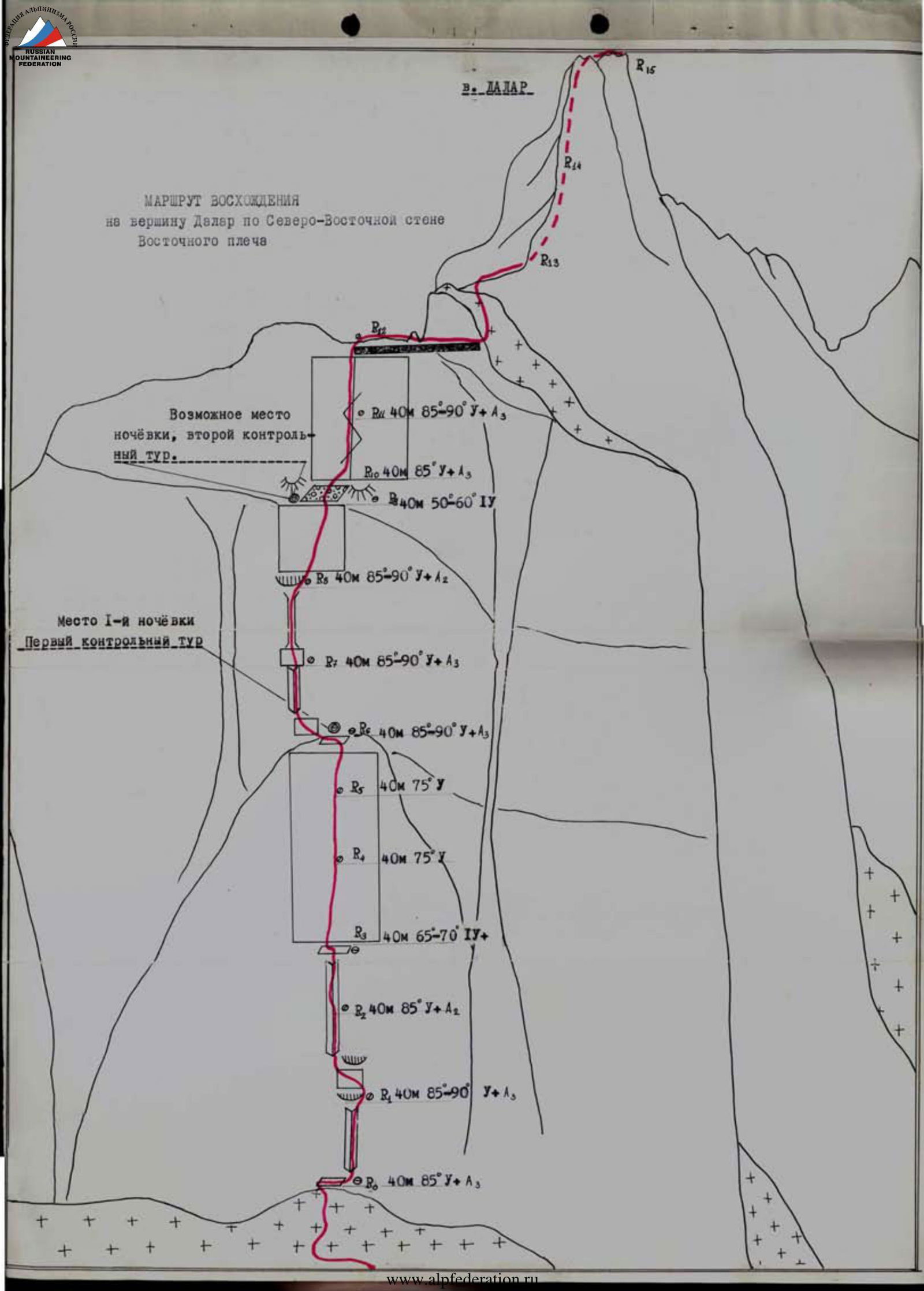
From the glacier plateau, approach the wall. Through a 1.5 m wide bergschrund to a ledge at the base of the wall (in the first half of summer, the ledge may be under snow).
Along the ledge to the right 15 m to the base of a wide internal corner, at the end of the ledge is a convenient place for belaying the first climber.
R0–R1. From the ledge, transition to the right side of the internal corner, then up 10 m along the right side and further 20 m along the corner under the first overhang to the R1 belay point. Climbing is extremely tense, with few holds and using ladders, piton belay. Section steepness is 85°.
R1–R2. From the R1 belay point, to the right, bypassing the first overhang (ladders!) and exit to a 10 m wall under the second overhang. Along the wall, left-up to the base of the internal corner and further up the corner to the R2 belay point. Climbing is tense with ladder use, piton belay. Section steepness is 85–90°.
R2–R3. From the R2 belay point, transition to the left side of the internal corner and straight up 30 m. Then transition to the right side and after 10 m, exit to a ledge to the R3 belay point. The Handling is with ladder use, piton belay, climbing is tense with few holds. Section steepness is 85°.
R3–R6. Along the ledge to the left 5 m and straight up the wall to an internal corner. This 120 m section with an exit to a ledge under the base of the internal corner. In the lower part of the wall (first 40 m), steepness is 65–70°, then to the ledge - 75°. Climbing is complex but with reliable holds, piton belay.
On the ledge, together with the R6 belay point, the first control point is laid out, a good platform for a tent.
R6–R7
- From the ledge along an 8 m wall to the left-up to the base of the internal corner
- Along the corner 30 m to the R7 belay point under a vertical 5 m wall
- The section is passed with thorough piton belay, using ladders
- Section steepness is 85–90°
R7–R8
- From the belay point straight up the wall and after 5 m, enter the chimney
- Along the chimney 35 m under the overhang at its top
- Here is the R8 belay point
- The section is passed with thorough piton belay and ladder use
- Holds are small, climbing is tense, sometimes in compression
- Section steepness is 85–90°
R8–R9
- From the belay point to the right under the overhang and exit to the wall
- Along the wall to the right-up 40 m of tense climbing with piton belay and ladder use
- After 40 m, exit to a wide scree ledge
- Here is a convenient belay point, a good platform for a tent is laid out, the second control point
- Section steepness is 85–90°
R9–R10
- From the wide scree ledge straight up along rocks like "sheep's foreheads" with a steepness of 50–60° to the base of the wall, a place where it is crossed by a vaguely expressed vertical corner with a crack. Climbing is not complex, piton belay.
R10–R12
- Along the crack straight up 80 m with an exit to the ridge of the Eastern shoulder. Climbing is tense, with few holds, using ladders. Section steepness is 85–90°.
- After passing the first 30 m, overcome a 3 m overhang.
R12–R15
- From the R12 belay point to the summit, the route follows category 5A.
The presented route was first climbed as part of the USSR Championship in 1978 by a team from the "Ullutau" alpine camp led by Yu. Porokhnya. The North-Eastern wall of the Eastern shoulder of Dalar peak is rated higher than typical routes of 5B category and is one of the most complex routes in the area.
TRAINER OF THE TEAM N. Krasnoshchekov LEADER A. Severnyuk
Ascent Passport
- Class of technical ascents.
- Area 2.3, Caucasus, from Nakhar pass to Chipperazau pass.
- Dalar, 3979 m, point 30, Yu. Porokhnya's route, 1978, via the NE wall of the E shoulder, combined route.
- 5B category.
- Route characteristics: height difference - 630 m, wall part height difference - 400 m (from 3350 m to 3750 m), average wall steepness 62°, route length - 1880 m, wall part length - 555 m, summit tower length - 390 m, section lengths: 2nd category - 395 m, 3rd category - 455 m, 4th category - 370 m, 5th category - 575 m, including 15 m on artificial support, 6th category - 25 m, including 10 m on artificial support, total climbing on artificial support - 25 m, complexity A1.
- Used on the route: rock pitons 102/7, chocks 63/3, bolt pitons 7/3, including previously left rock pitons 4 (1 was removed), bolt pitons 7. Own equipment was not left.
- Team climbing days - 3; hours - 28, including preliminary processing - 6.
- Bivouacs: first (2700 m) in a "green pocket" on the lateral moraine (right) of the Big Kichkenekol glacier after preliminary processing, lying in tents; second (3750 m) on the ridge of the E shoulder - lying in a tent on a laid-out platform.
- Leader: Smotrov Sergei Ivanovich - Candidate Master of Sports
Team members:
- Aliyev Shankhal Ramazanovich - 1st sports category
- Velikanov Vladimir Yurievich - Candidate Master of Sports
- Dorro Konstantin Eduardovich - Candidate Master of Sports
- Nurbagandov Gadzhimurad Musaevich - Candidate Master of Sports
- Shanavazov Shanavaz Eldarovich - Candidate Master of Sports
- Coach: Murtazaliev Ziyavudin Murtazalievich
- Departure from Uzunkol base - July 18, 1997 Preliminary processing - July 19, 1997 Departure from "green pocket" - July 20, 1997 Summit - July 21, 1997 Return to Uzunkol base - July 22, 1997
- Organization: Dagestan Republican Search and Rescue Service of the Russian Ministry of Emergency Situations.
Technical and Tactical Actions of the Team
The team knew the climbing area from ascents in 1990, when they climbed V. Stepanov's 1962 route - 5B and B. Korablin's 1975 route - 6A. The area is very interesting in sports terms with very beautiful and logical routes, some of which are benchmark. Yu. Porokhnya's 1978 route belongs to such classic routes. The variety of terrain: alternation of ice and rock, wall sections and ridge sections, "dyulfers" on the route make it technically complex. Unstable weather in the area, especially in the summer of 1997, also complicates the ascent.
Arriving in the climbing area on July 15, the team, assistants, and other training participants conducted acclimatization climbs on the Dolomites on July 16 and 17, from where they studied the condition of the approaches along the Big Kichkenekol glacier under the wall, the condition of the ridge part of the route, and the snow-ice nose.
On July 18, the team departed from the base camp located above the Uzunkol base. At the Russian border post, after a 3-hour approach, at 17:00, the team set up a camp in the "green pocket" of the right moraine of the Big Kichkenekol glacier. They observed the wall (through optics), prepared for work the next day.
On July 19, the team departed for processing at 6:00, Aliyev and Dorro remained in the camp. The rest went under the wall. After passing the glacier crevices, the group approached the bergschrund at 10:00. They unpacked equipment, changed, and at 11:00, Shanavazov began working on the rocks. Nurbagandov belayed. They used a UIAA rope (Beal, Spain, 11 mm). The first climber pulled a static rope 10 mm (Russia), clipped it into places of bend and change in direction. The team took 5 static ropes and one dynamic rope (50 m each) to the route. Shanavazov passed 5 ropes by 17:00, the rest left equipment at the stations, and by 18:00, everyone descended to the glacier. At 20:00, they returned to the camp in the "green pocket". Passing these ropes was complicated by wet rocks after rain and melting snowfields in the upper part of the wall; in some places, artificial support was used.
On July 20, the team departed from the moraine bivouac at 5:00, passed the glacier by 8:00, approached the wall, and began moving along the fixed ropes, which they passed by 11:30. At 12:00, when they brought the fixed rope, the Nurbagandov-Dorro rope team began working further. At 17:00, it started raining, then hailing. The first climber was passing section 11–12 at this time. By 20:00, having passed 8 ropes (after the processed ones), the group reached the ridge of the Eastern shoulder. They cleared a platform and set up a tent. The bivouac was relatively comfortable. The bad weather continued until 1:00 am (sleet, sharp gusty wind).
On July 21, the group departed from the bivouac on the shoulder at 7:00, passed a simple ridge, bypassing climbs to the right, approached a large climb along blocks and ledges to the stop on the right of the climb. Then "dyulfer" into the groove between the climb and the slope of the snow nose. The snow on the nose was bad, it crunched underfoot like "board", and the first rope team, Dorro-Shanavazov, had to hang three ropes. When they organized a station on the ridge and all ropes were tied together, the rest began moving along the "nose".
At 12:00, the team reached the foot of the summit tower, passed complex ropes, and the so-called "Warburton wall". At 17:00, the group reached the summit, where they found a note in a cairn, burned by lightning (the paper crumbled).
The team began descending along the 3B route to the south, on the descent, they fixed ropes in the couloir, everyone worked in crampons, but had to belay: snow was sticking. At 20:30, the team reached the Dalar pass, where they bivouacked on a platform.
On July 22, 1997, at 13:00, the team returned to the base camp at the border post.
The tactical plan of the ascent was fully implemented according to the days and hours of the ascent, according to the bivouac locations. On the route, various rock pitons and chocks (stoppers, hexes, rock rucks) were used to the fullest extent. In some places, bolt pitons hammered by previous groups were used. They had to use artificial support, although the team tried to pass the route with free climbing as much as possible. Sections passed on artificial support were complicated by wet rocks.
During the ascent, a rescue team was located in the base camp:
- Krasnopolsky Yu.V. - Candidate Master of Sports
- Leonov P.G. - Candidate Master of Sports
- Sogokon V.A. - Candidate Master of Sports
- Skornyakov A.N. - Candidate Master of Sports, as well as assistants (4 people - 1st sports category).
A ZIL-131 vehicle with a K.V. radio station was located in the base camp; communication with the North Caucasus and Makhachkala was conducted 3 times a day. Between the team and the base camp, communication was conducted on a UKV radio station "Standard" (Japan) three times a day.
In the rescue kit:
- first-aid kit
- blood transfusion system
- dropper
- "Paramedic" stretcher
- vacuum splints
Also, rescue equipment:
- winch and 500 m of cable (6 mm)
- rope winch "Petzl"
The rescue team had sufficient training and sports form to perform their functions.
The team passed the route with a reserve of physical and moral strength.
Route scheme according to Yu. Porokhnya - 78, 5B cat. sl. Dalar via the NE wall of the E shoulder, in UIAA symbols. Scale 1:2000.
Legend: Pit. Ch. Bolt (Pitons, Chocks, Bolt pitons), Section length, m, Steepness, °.
Points marked on the scheme:
- 3750 m, ridge of E. shoulder. Bivouac on July 20, 1997.
- Large oblique ledge.
- "Water!".
- "End of processing on July 19, 1997".
- "Bergschrund of Big Kichkenekol glacier".

Scheme of Yu. Porokhnya's route - 78, 5B cat. sl. via the NE wall of the E shoulder, in UIAA symbols. Ridge part and summit tower.
Main points on the scheme:
- V. Dalar 3979 m. Summit on July 21, 1997.
- V. shoulder 3750 m. Bivouac on July 20, 1997.
- L. B. Kichkenekol.
- NE wall. NE edge. Bastion. Double.
- Dyulfer 40 m, 80°, 3 pitches.
- Descent 20 m, 80°.

Route description
From the "green pocket" of the right moraine of the Big Kichkenekol glacier, cross the river fed by the Middle Kichkenekol glacier and exit to the Big Kichkenekol glacier along the moraine and scree slope. Further - to the left of the ice fall in the center of the glacier, beware of falling ice from the hanging glacier in the area of g. Zamok. Exit to the plateau and move to the right under the second (from the left) triangular slab-wall leaning against the wall of the Eastern shoulder. Bergschrund. Under the wall is a ledge with ice. Along a complex wall (sect. R0–R1) under the overhang and left-up along the corner-slab (sect. R1–R2) enter a wide internal corner (sect. R2–R3), move traverse under the base of the chimney (uncomfortable fixed ropes). Further along a system of corners and chimneys, exit to the top of the triangle (sect. R3–R5). Bivouac possible, cairn.
Further left-up under the chimney - the entrance to it is blocked by a complex steep wall (sect. R5–R7). Steepness increases: the top of section R7–R8 (internal corner) is blocked by overhangs, very complex climbing, wet rocks. Along the corner and wall (sect. R8–R10) with rocks like "sheep's foreheads", exit to an oblique ledge and along it to the left (sect. R10–R12) under the overhang. Bivouac possible, cairn.
Further almost vertically up to the ridge of the E shoulder, in some places very complex climbing, but everything is logical (sect. R12–R15). On the ridge is a place for a tent.
From the bivouac along the ridge, a rock climb is bypassed to the right along a narrow ledge (sect. R17–R18), reaching a sharp turn around the corner (left), gain height along large-block rocks (sect. R18–R19) and pass along a narrow ledge (sect. R19–R20) to a descent loop. Descent to the slope of the "nose". Along the slope of the "nose" to the ridge and again exit to the E shoulder (sect. R21–R23). Attention! Avalanches and "board" are possible down to the right. Be careful with belay.
Then along the ridge with small climbs and descents of medium complexity (sect. R23–R28), approach under the summit tower; the ridge is blocked by a triangular yellow wall. Traverse to the right of the ridge and along corners and walls, exit to the summit ridge, along it - to the summit. On the tower are large-block rocks, in some places destroyed (sect. R28–R34). On the summit - a cairn (3979 m). Descent along route 3B to the south and through the Dalar pass to the Myrdry gorge.
Ascent Passport
- Western Caucasus, Uzunkol gorge, route 2.3.28
- V. Dalar via the NE wall of the E shoulder
- Complexity category - 5B
- Route character - combined
- Route height difference - 850 m Route length - 1730 m. Length of sections with 5-6 cat. sl. - 500 m Average steepness: main part of the route - 68°, total route - 45°
- Pitons left on the route: total 0
Pitons used on the route:
- stationary bolt pitons - 2, including artificial support - 0
- removable bolt pitons - 0. Total artificial support used - 2
- Team climbing hours: 24 hours, 3 days
- Leader: Puchnin Vyacheslav Evgenievich, Master of Sports
Team members:
- Zaitsev Yury Anatolievich, 1st sports category
- Solovyov Andrey Vasilyevich, Candidate Master of Sports
- Coach: Puchnin Vyacheslav Evgenievich, Master of Sports
- Departure on the route: 10:00, July 28, 2001 Summit: 11:30, July 30, 2001 Return to Uzunkol VSC - 21:00, July 30, 2001
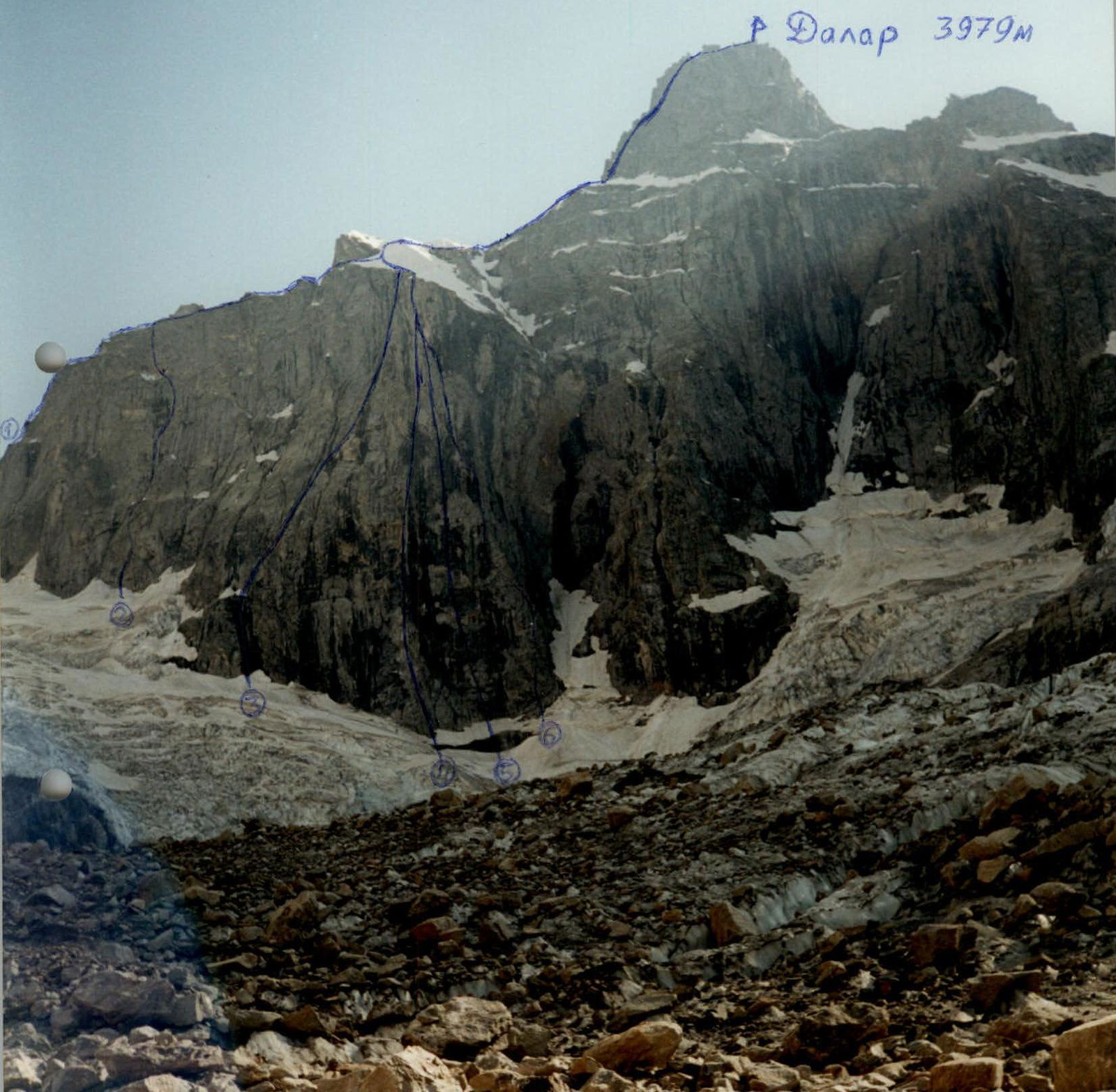
Routes to Dalar peak
- Kavunenko's route, 5A cat. sl.;
- Porokhnya's route, 5B cat. sl., climbed by the Perm OSK team on July 28-30, 2001;
- Kavunenko's route, 5B cat. sl.;
- Korablin's route, 6A cat. sl.;
- Ivashchenko's route, 5B cat. sl.;
- Warburton's route, 6A cat. sl.
Website: www.alp-federation.ru↗

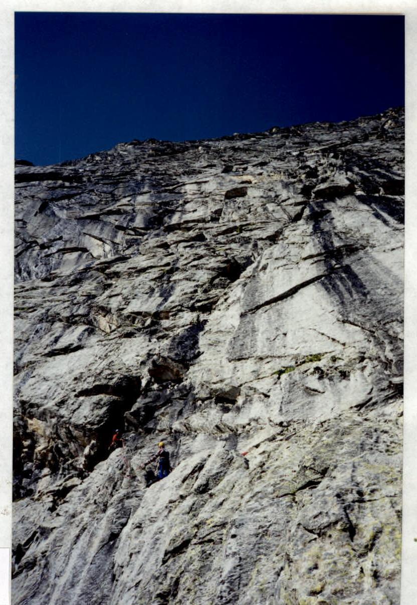
Technical photograph of the wall part of Porokhnya's route via the NE wall of the E shoulder
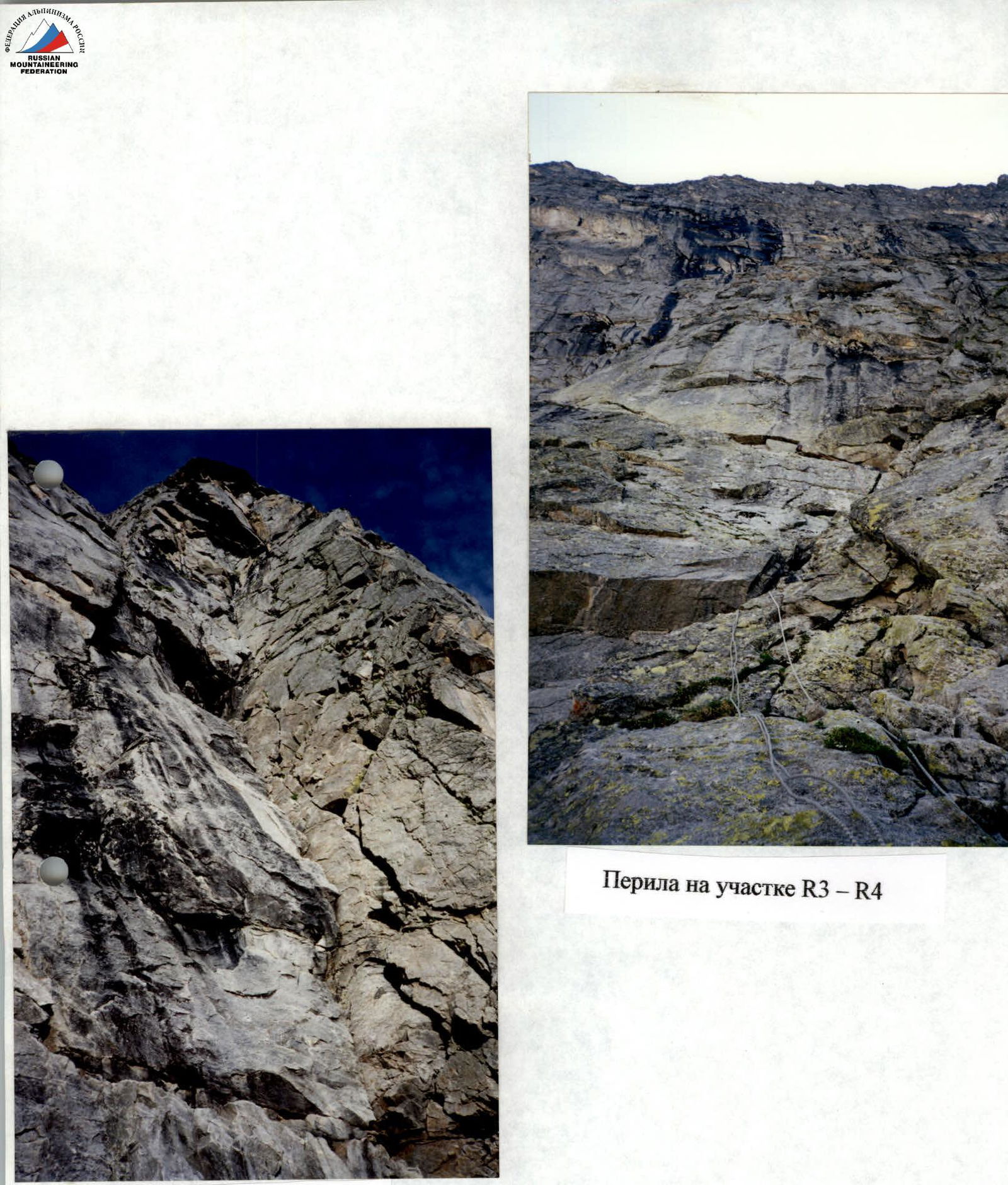
Fixed ropes on section R3–R4
Section R0–R3
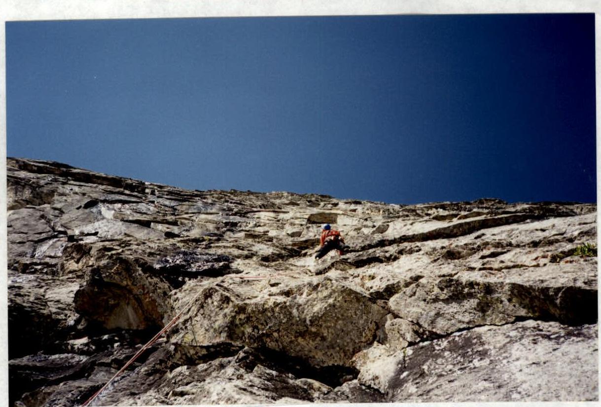
Passage of section R10–R11
Start of passage of chimney R8–R10