
St. Petersburg Alpinism Championship. Category — High-Altitude Technical 2024
Report on the Ascent to Dalar Peak (3988 m) via the Northeast Ridge (V. Stepanov Route, 1962), 5B Category of Difficulty, Combined Terrain
The route was completed by the team from the Alpine Club of St. Petersburg, "OGK" association. Team Captain: A.V. Kichurchak.
Ascent Passport
| 1. General Information | ||
|---|---|---|
| 1.1 | Leader's Full Name, Sports Rank | Andrey Vladimirovich Kichurchak, 1st sports rank |
| 1.2 | Participants' Full Names, Sports Ranks | Elena Vadimovna Aleksandrova, 1st sports rank |
| 1.3 | Coach's Full Name, Sports Rank | D.M. Kiselev, Candidate Master of Sports |
| 1.4 | Organization | St. Petersburg Alpinism Federation, "OGK" association |
| 2. Characteristics of the Ascent Object | ||
| 2.1 | Region | Western Caucasus, Kichkinokol Valley |
| 2.2 | Route Number according to the Russian Electronic Classifier of Routes to Mountain Peaks / Route Number | From Nakhar Pass to Chipperazau Pass / 24A |
| 2.3 | Name and Height of the Peak | Dalar, 3988 m |
| 2.4 | Geographical Coordinates of the Peak | 43°13′27″ N, 42°9′53″ E (43.224060, 42.16467) |
| 3. Route Characteristics | ||
| 3.1 | Route Name | via Northeast Ridge (V. Stepanov, 1962) |
| 3.2 | Category of Difficulty | 5B |
| 3.3 | Relief Characteristics of the Route | combined terrain |
| 3.4 | Height Difference of the Route from R0 | 1000 m |
| 3.5 | Length of the Rock Section of the Route | 1350 m |
| 3.6 | Technical Elements of the Route | IV category of difficulty – 320 m, V category of difficulty – 380 m, VI category of difficulty – 250 m |
| 3.7 | Average Steepness of the Entire Route | 60° |
| 3.8 | Descent from the Summit | From the summit, 5 rappels of 30–55 m down the SW couloir of Dalar's tower, then — simultaneous descent down to the snow knife, followed by 18 rappels of 40–55 m along pre-drilled stations |
| 3.9 | Additional Route Characteristics | 1. Water is mostly found in the form of snow: snow knife and small snow patches along the ridge part of the route. 2. The exit to the large platform (R4) at the base of the ridge and the entire R4–R5 section are exposed to rockfall from the couloir between this route and the 6A category route on the N wall of the bastion (M. Warburton's route, 1976). |
| 4. Characteristics of the Team's Actions | ||
| 4.1 | Time of Movement (team's walking hours, indicated in hours and days) | 25.5 hours, 3 days |
| 4.2 | Overnights | Two overnights, lying down: 1st — July 25, on the R14 ledge; 2nd — July 26, on the summit tower in the ridge gap R28 |
| 4.3 | Time Spent on Route Processing | Without processing |
| 4.4 | Exit onto the Route | July 25, 2024, 3:30 |
| 4.5 | Reach the Summit | July 27, 2024, 8:30 |
| 4.6 | Return to the "Green Pocket" Campsite | July 27, 2024, 22:30 |
| 5. Weather Conditions Characteristics | ||
| 5.1 | Temperature | –1°C – +10°C |
| 5.2 | Wind Force | July 25 — calm; July 26 — gusty stormy after 17:00; July 27 — 1–4 m/s, occasionally gusty |
| 5.3 | Precipitation | July 25 — no precipitation; July 26 — no precipitation until 17:00, then unstable weather, thunderstorm, lightning, wet snow, rain (shower/drizzle), hail; July 27 — unstable weather, rain (shower/drizzle), wet snow in some places — throughout the day |
| 5.4 | Visibility | July 25 — clear, good visibility; July 26 — clear until 17:00, then cloudy, fog; July 27 — cloudy throughout the day, fog |
| 6. Responsible for the Report | ||
| 6.1 | Full Name, e-mail | Elena Aleksandrova, alpinizm78@mail.ru |
Description of the Ascent Area
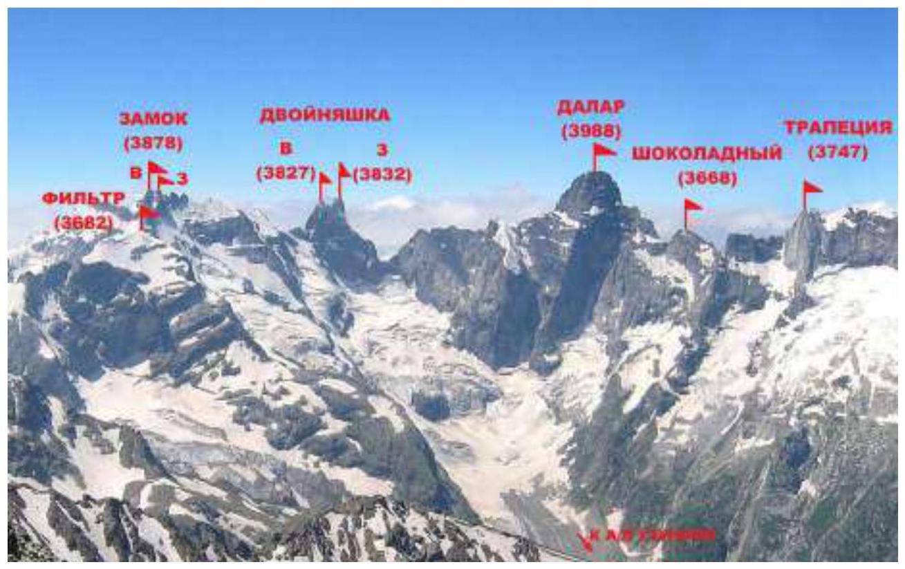
Dalar (3988 m) is one of the most beautiful peaks in the Caucasus. Dalar is located in the Gvandrinsky region of the Western Caucasus within the Central Uplift of the Main Caucasian Range, 25 km southwest of Elbrus. The peaks of this region are mainly composed of strong granitic-gneiss rocks with minimal cracks and smoothed microrelief.
The main peaks of the Gvandrinsky region: Kirpich (3751 m), Dalar (3988 m), Dvoynashka (3832 m), Zamok (3878 m), and Trapeция (3747 m) generally do not have easy paths; their walls are among the most challenging in the Caucasus.
List of peaks:
- Kirpich (3751 m)
- Dalar (3988 m)
- Dvoynashka (3832 m)
- Zamok (3878 m)
- Trapeция (3747 m)
The chain of peaks Filter — Zamok — Dvoynashka — Dalar — Shokoladny Peak, located in the upper reaches of the Kichkinokol Valley, bounds the Big Kichkinokol glacier cirque from the east, west, and south, giving rise to the eponymous river that flows into the Uzunkol River.
List of peaks:
- Filter
- Zamok
- Dvoynashka
- Dalar
- Shokoladny Peak
The first ascent to Dalar was made in 1937 by a group led by Kizel and Budanov via the 4A category route from Dalar Pass. According to the Russian Electronic Classifier of Routes to Mountain Peaks, there are currently 21 mountaineering routes to Dalar's summit, including:
- Five routes with a 6A category of difficulty;
- Eight routes with a 5B category.
Routes to Dalar are classic examples of technically complex mountaineering and have repeatedly won prizes in championships.
To date, the sporting potential of the peak is far from exhausted. Due to the significant extent of its northern, northeastern, and eastern walls, Dalar continues to attract mountaineers:
- North wall,
- Northeast ridge,
- East wall.
Panorama of the Ascent Area
Approach to the Campsite
From the Uzunkol tourist base, move towards the Dolomite campsite. Before reaching the turn that begins the steep ascent to the Dolomite campsite, cross to the left (orographically) bank of the Kichkinokol River and follow the trail along the river. The trail leads to the lateral moraine of the glacier and continues along its sharp ridge.
At the "green pocket" campsite, there are:
- 3 platforms for tents
- Water (waterfall)
From the Uzunkol tourist base — 2–3 hours.
Map-scheme of the area with the approach to the "green pocket" campsite

Ascent Description
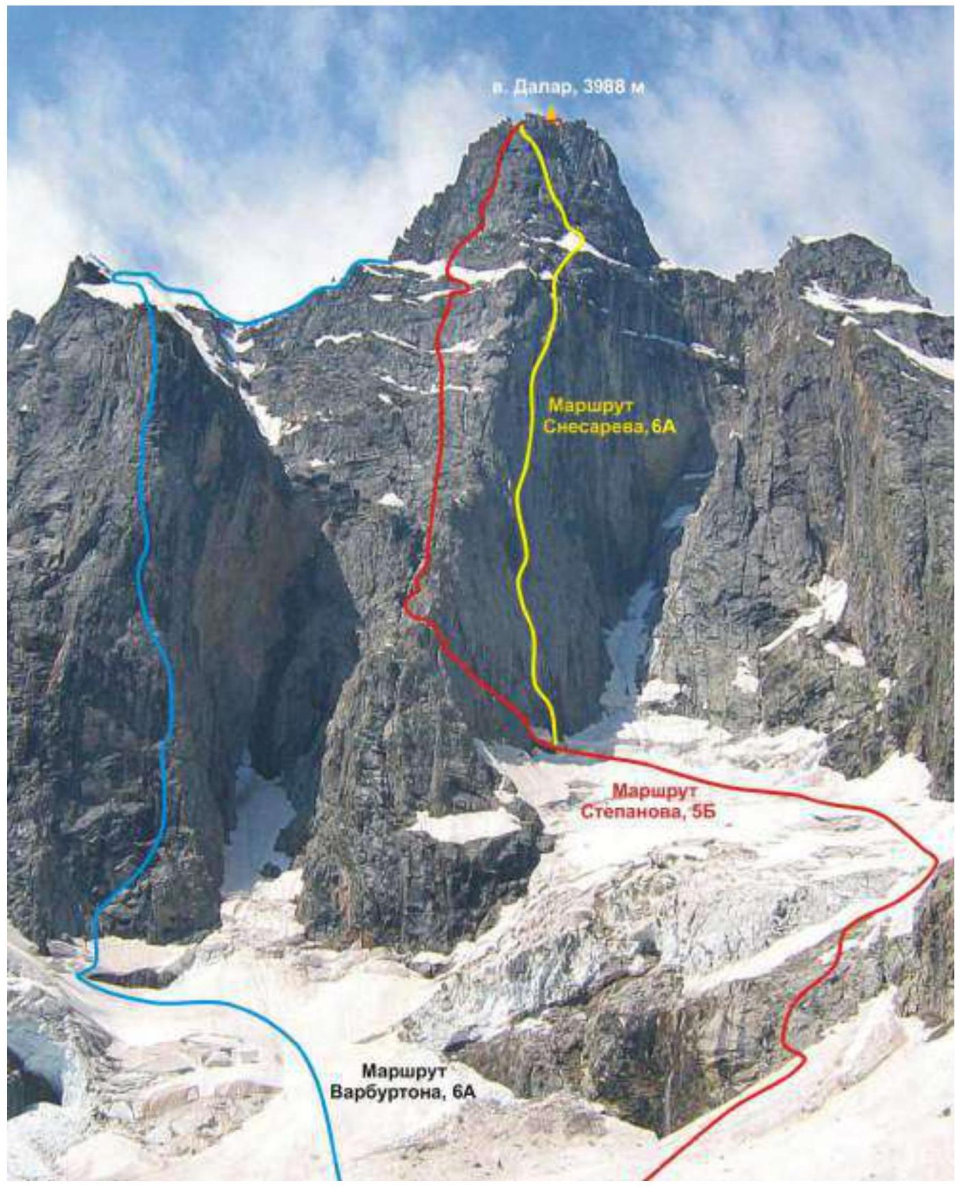
General photo of the route with nearby routes indicated
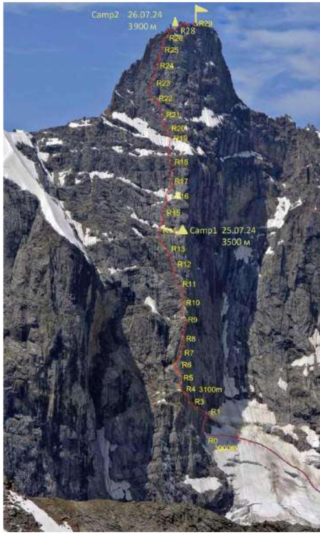
 Technical photo of the route
Route Description by Sections
The route to Dalar via the NE ridge is characterized by free climbing and a logical path. Each rock belt, of which there are three, is more challenging than the previous one. One of the difficult areas is the 120-meter upper internal corner-chimney.
Approach to the route:
- From the campsite on the moraine of the Big Kichkinokol glacier, descend to the glacier and move to the right towards the North Dalar glacier.
- Ascend the snow slope and then via the "goat's foreheads" to the left of the waterfall flowing from the glacier to the base of the glacier under Dalar's north wall.
- Along the glacier, approach the base of the ice couloir between the North wall and the NE ridge.
From here, the route begins: it is necessary to reach a rocky scree ledge 120 m long, leading left onto the NE ridge crest. Between the start of the route and the glacier, there is a fairly wide randkluft. Upon approaching the route, the team found that all the rocks were wet with ice in the crevices. Thus, initially, it was necessary to:
- Descend into the randkluft,
- Then climb up the wet rocks.
It will take a considerable amount of time to start the route in such conditions. The team decided it was целесообразно to search for a more convenient ascent to the rocks where they could climb without using IT.
Such an approach was found slightly to the left of the start of the route from the classic description:
- Traversing left about 70 m along the ice slope (steepness 60°), the team found a place to set up a station R0.
- The width of the randkluft in this location allowed them to step over it, holding onto the rocks (see the "Route Photos" section).
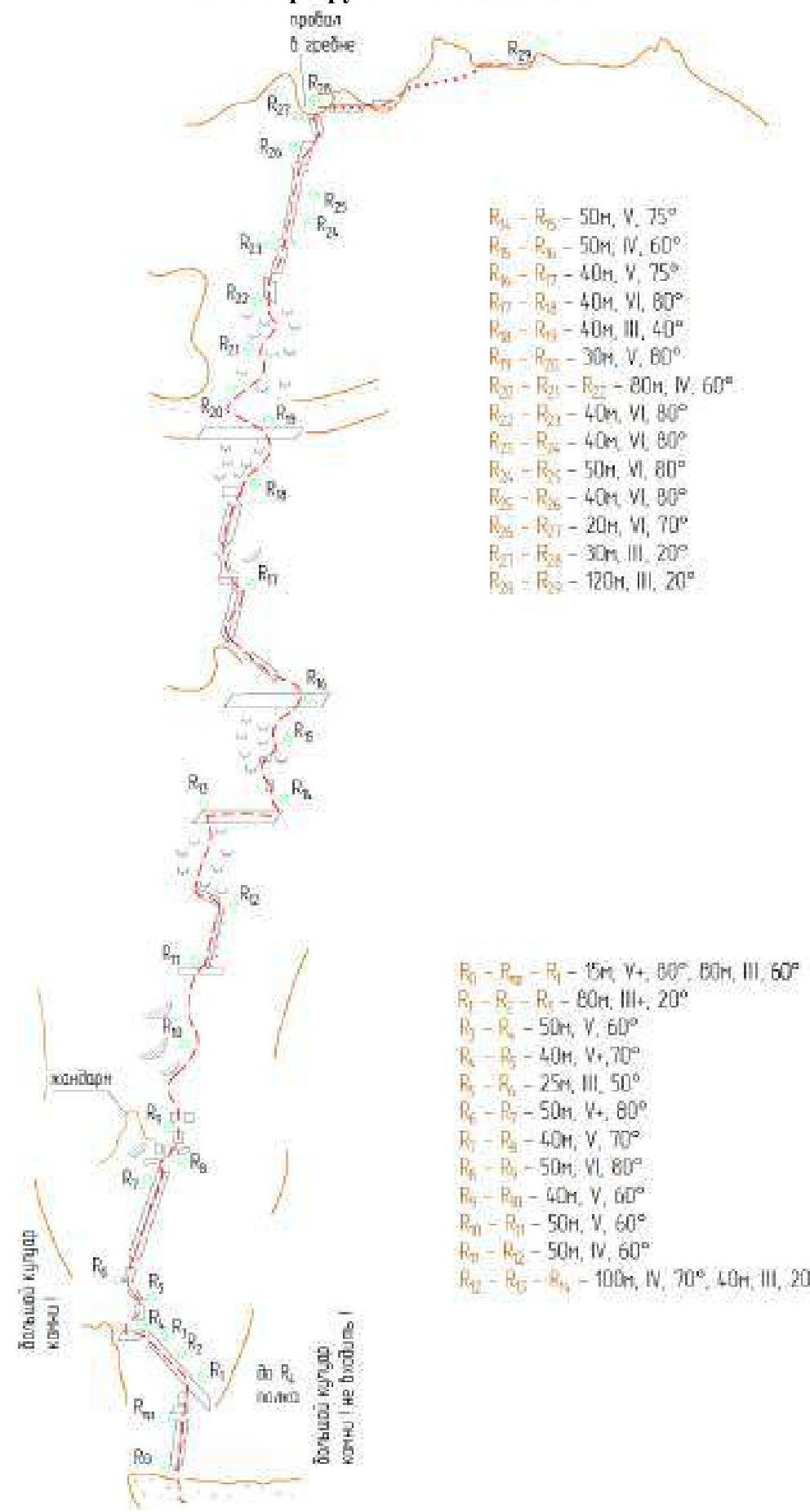
R0–R1 (15 m, V+, 80°, 80 m, III, 60°)
After crossing the randkluft, ascend steep wet rocks to a rock ledge with remnants of a glacier on top (15 m, V+, 80°). Continue up a series of ledge-wall (made an intermediate station Rпр.) to a large scree ledge (80 m, III, 60°).
- R1–R2–R3 (80 m, III+, 20°): left along the scree ledge 70 m. Reach steep semi-destoyed rocks under the base of the NE ridge.
- R3–R4 (50 m, V, 60°): up and left along semi-destroyed rocks of medium difficulty, exit to the NE ridge crest. Large platform at the base of the ridge, exposed to rockfall!!
- R4–R5 (40 m, V+, 70°): up along a monolithic wall to a ledge and then overcome a second steep wall with a fissure, exit to a wide terrace. Exposed to rockfall!! It is advisable to set up a station as far right as possible, protected by a rock from potential rockfall.
- R5–R6 (25 m, III, 50°): left along a wide ledge transitioning into a wide internal corner, crawl under an overhang. Semi-hanging station, well-protected from rocks. Orientation — a grotto. Do not go into the couloir; it's rocky.
- R6–R7 (50 m, V+, 80°): up and right along a rock wall transitioning into an internal corner with red rocks and bushes. Exit onto rock slabs on the NE ridge crest. There are two bolts on the path.
- R7–R8 (40 m, V, 70°): along rock slabs, approach the base of a belay post from the right. Whitish rocks at the base of the belay post.
- R8–R9 (50 m, VI, 80°): right of the belay post, ascend a rock slab and an internal corner with an overhang, exit to a saddle between the belay post and the NE ridge. There are pitons. Small ledge.
- R9–R10 (40 m, V, 60°): from the ledge, overcome a steep wall and continue up more gentle rocks.
- R10–R11 (50 m, V, 60°): up and left, exit to a 50 m ledge.
- R11–R12 (50 m, IV, 60°): up along rock slabs and "goat's foreheads." Orientation — a large fissure remains to the right.
- R12–R14 (100 m, IV, 70°; 40 m, III, 20°): 100 m up a wall and rock slabs, exit to a scree ledge. Traverse right 40 m along the ledge to set up an overnight camp in a good location under two large overhangs. The team's first overnight camp. 680 m from the start of the route.
- R14–R15 (50 m, V, 75°): up a steep wall to the right 15 m and then up a more gentle slab.
- R15–R16 (50 m, IV, 60°): up and right, exit to a second large scree ledge.
- R16–R17 (40 m, V, 75°): up and right along a monolithic slab, exit into a left narrow internal corner. Ascend the internal corner under an overhang.
- R17–R18 (40 m, VI, 80°): overcome the overhang on the left via a chimney-fissure. Exit to a small ledge. From the ledge, ascend vertically, using bolts.
- R18–R19 (40 m, III, 40°): along a scree ledge (snow patch in the upper part) ascend to the base of a rock wall.
- R19–R20 (30 m, V, 80°): left along a ledge and snow patch, exit to rocks, overcome a small overhang.
- R20–R21–R22 (80 m, IV, 60°): ascend left along rocks resembling "goat's foreheads" at an angle of about 40–45° to the base of the chimney. Exit to a flat platform under steep rocks, a loop on a stone. A wide internal corner remains to the right. From this point, the challenging section of the route to the summit tower begins.
- R22–R23 (40 m, VI, 80°): left along steep rocks and up a fissure, overcoming an overhang, exit right into the base of the 120 m internal corner-chimney. Station.
- R23–R24 (40 m, VI, 80°): ascend the right wall of the chimney. Good relief. Exit to a station.
- R24–R25 (50 m, VI, 85°): ascend the chimney in a stem and along the right wall, overcoming overhangs.
- R25–R26 (40 m, VI, 80°): up the chimney and then along a rock slab, exit to an inclined ledge leading right.
- R26–R27 (20 m, VI, 70°): overcome a steep wall with a fissure head-on and then complex climbing along a slab, exit to a belay post-slab visible against the sky.
- R27–R28 (30 m, III, 20°): along destroyed rocks, traverse into a gap in the ridge. Exit to the south side of the summit tower. On the summit tower, in the ridge gap, there is a small horizontal ledge that can accommodate a compact two-person tent. The team's second overnight camp.
- R28–R29 (120 m, III, 20°): right along the ridge and simple rocks, bypass a belay post on the left, and then continue along the ridge to the summit.
Descent
- From the summit, descend to the south side of the summit tower and then move to pre-drilled rappels from the lower part of the snow knife.
- Directly from the summit, descend slightly along the ridge via the ascent path to a cairn, then follow 5 pre-drilled rappels.
- After the first rappel (20 m), there is a good horizontal platform protected by overhanging rocks. There's a place for a tent for an overnight stay. Opposite the platform, the bolts of the second rappel are visible.
- After the rappels, descend climbing one rope down to the base of the summit tower onto a ledge running along the entire tower.
- Traverse along the ledge left 200 m.
- Exit to the shoulder of the East ridge. A good place for an overnight stay (several platforms for tents are equipped).
- Continue along simple rocks towards the snow-ice ridge.
- Overcome a descent-ascent of 10–15 m (the team descended via rappel).
- Reach the upper part of the snow knife, where there is a rappel loop and a station on bolts a few meters away.
- Two rappels of 60 m and 40 m, and then exit onto rocks.
- At the end of the rock ridge, exit to a rappel station (bolts marked with green paint).
- Complete 18 rappels (length 40–55 m).
- Exit onto the glacier from the last rappel is complicated by overcoming a large randkluft. The first participant had to descend into the randkluft and then climb out in crampons on firm snow.
- Descend the glacier in pairs. In the middle part of the glacier, there are two large crevices. During this section, the team avoided all crevices; there were no bridges.
- Continue descending the glacier to the moraine and the "green pocket" campsite.
- Descend to the Uzunkol tourist base along the trail.
Safety Assessment of the Route. Recommendations for Climbers
- It is advisable to start the route no later than 3:30. The approach to the route is exposed to rockfall. The team approached the start of the route at 5:40, and after that, the ascent path began to be hit by rocks. Throughout the day until R14, the team observed falling rocks onto the glacier. Therefore, it is recommended to approach the route only early in the morning.
- The exit to the large platform (R4) at the base of the ridge after the scree inclined ledge, as well as the entire R4–R5 section, is exposed to rockfall from the couloir between this route and the 6A category route on the N wall of the bastion (M. Warburton's route, 1976).
- During the passage of this section, a rockfall occurred. Large rocks fell in the couloir, hit the rocks, and broke into smaller stones. By ricochet, they flew onto the R4 ledge (R4), hitting the entire R4–R5 section. The station on the ledge (R4) was set up at the base of the rock behind a turn. Therefore, the belayer was hit with a few blows to the helmet. The leader, being on the organized station above (R5), received stronger blows to the helmet and arms. After waiting for the rockfall to cease, the leader moved right, crawled higher under the overhanging rocks, and set up a station under a fissure. It is recommended not to linger on this section and to set up station R5 under the overhanging rocks, under a fissure that is located slightly to the right of the previous descriptions.
- The entire scree ledge R1–R4 is covered in loose rocks. Handholds are unreliable; rocks crumble in hands.
- The start of the next rappel should be found based on the logic that the rappel station should be set up in a safe location: under overhanging rocks or slightly to the side of the upper station, not directly under it. This year, red reepschnur were added to the stations, making them easier to spot. On the diagonal rappel, at the end of which a waterfall begins, it is necessary to traverse along a horizontal ledge to the right without descending further down along the waterfall. Then, look for a rappel station on the right wall.
Route Diagram in UIAA Symbols
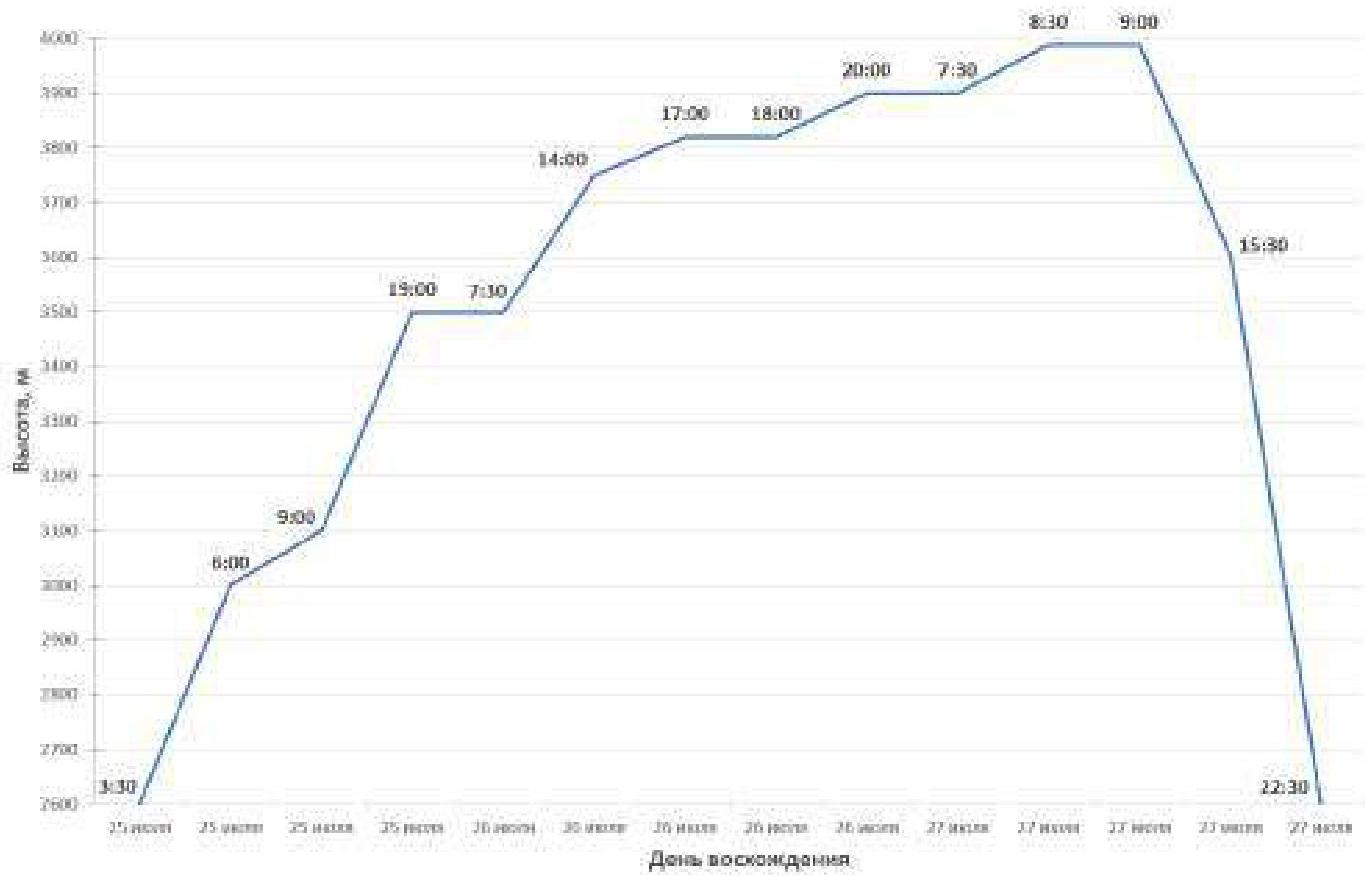
Ascent Schedule and Weather Conditions
The total length of the rock section is 1350 m.
On the first day, July 25, 680 m were covered from R0 (3000 m) to R14 (3500 m).
On the second day, July 26, 550 m were covered from R14 (3500 m) to R28 (3900 m).
On the third day, July 27, 120 m were covered from R28 (3900 m) to R29 (3988 m).
On the third day, July 27 — descent from the route.
Weather conditions in the ascent area in July were challenging. Unstable weather, frequent thunderstorms and rains contrary to weather forecasts, as well as abnormally high temperatures in the mountains led to a reduction in the duration of weather windows and their unpredictable shift by several days.
For July 25, 26, 27, the forecast promised a weather window, with only a slight deterioration expected in the second half of July 27. In fact, an unexpected thunderstorm front caught the team on July 26 while working on the summit tower in the corner-chimney at 17:00 (R24–R25 section). Further passage of the route and descent to the tourist base occurred in cloudy weather with precipitation.
Weather conditions by day:
- July 25 — good weather, clear, no precipitation.
- July 26 — good weather until 17:00, then shower, thunderstorm, wet snow, gusty wind, fog.
- July 27 — drizzle throughout the day, wet snow in some places, cloudy.
The unexpected thunderstorm front caught the team on July 26 at 17:00 while working on the summit tower in the corner-chimney (R24–R25 section). Further passage of the route and descent to the tourist base occurred in cloudy weather with precipitation.
July 24, 2024 (approach 2 hours)
Departure from the Uzunkol tourist base to the "green pocket" campsite: 10:00 Arrival at the "green pocket" campsite: 12:00
July 25, 2024 (13 working hours)
Departure onto the route from the campsite: 3:30 Start working on the rock section (R0): 6:00 Start working under the base of the NE ridge (platform R4): 9:00 1st overnight camp (ledge R14): 19:00
July 26, 2024 (11.5 working hours)
Start working on the route: 7:30 Reach the chimney of the pre-summit tower (R22): 14:00 Weathering bad weather (R24–R25): 17:00–18:00 2nd overnight camp in the ridge gap of the tower (R28): 20:00
July 27, 2024 (1 working hour)
Start working on the route: 7:30 Reach the summit: 8:30 Start descending from the tower: 9:00 Descend to the start of 18 rappels: 15:30 Descend onto the glacier: 20:30 Return to the moraine campsite: 22:30
Tactical Actions of the Team and Free Description of the Team's Actions
Team Preparation
The "OGK" alpine club team, before ascending Dalar with a 5B category of difficulty, conducted acclimatization hikes in the Uzunkol tourist base and completed two sports ascents: Uzunkol Peak 2B, Dalar 5A (Kavunenko's route, 1964). The level of rock climbing preparation of all team members allowed them to pass complex sections with free climbing. In bad weather conditions, perils were also used. For Elena Aleksandrova, the route completed was the second 5B category route, for Andrey Kichurchak — the third.
Route Passage
The team completed the route according to the tactical plan in three days with two overnights without prior processing. Both participants climbed with backpacks. The leader's insurance was carried out with two dynamic ropes. All sections were led by the leader with free climbing, with the second participant being belayed with a heavier backpack via top-rope. Some sections were climbed simultaneously with intermediate protection between participants. The rock section of the route is monolithic not everywhere; there are areas with semi-destroyed rocks and loose stones. When exiting onto ledges after each rock belt, there are many loose stones. The first overnight camp was set up on a large ledge R14. When approaching the summit tower, it is necessary to stay to the left, choosing the simplest and most reliable path for passage. The 120-meter vertical internal corner-chimney on the summit tower (R23–R28) is the most complex and interesting section of the route.
The group worked on the tower with full backpacks. Initially, it was planned to reach the summit on the second day and set up an overnight camp on the descent on the south side of the tower. However, unexpected weather deterioration made adjustments to the plan. Being on a station two ropes from the top of the tower, at 17:00, the group was caught by an unexpected thunderstorm and subsequent weather deterioration contrary to the forecast. They waited out the thunderstorm and heavy rain under a tent and sleeping pads. As the thunderstorm was ending, they decided to climb the remaining two ropes to the summit. The option of rappelling down to the base of the tower was considered. But they decided that:
- Everyone was already soaked,
- The next day, they would have to climb the tower again, wet, with wet ropes,
- It was uncertain whether the weather would allow them to exit the tent,
- Descending to the base of the tower would also take time, and it was unclear if it would be faster than climbing the two remaining ropes to the summit.
They waited for the thunderstorm to pass and for the rain to turn into drizzle. They carefully climbed the two ropes: the leader with free climbing, the second with a heavy backpack on perils. The second overnight camp was set up at 20:00 in the ridge gap of the summit tower on a good horizontal platform surrounded by rocks. The next morning, the weather was still unstable, with drizzle, fog, and no thunderstorms. Soaked through since the previous day, without the ability to dry out in cloudy weather, with wet camping gear, at 7:30 they continued movement: covered 120 m along the ridge, reached the summit at 8:30. Then — descent from the summit. The group's cohesion, as well as the reconnaissance of the descent during the previous ascent, allowed participants to safely descend from the route according to the tactical plan.
List of Equipment Used
- Main rope — 2 pcs.
- Reepschnur 5 m — 3 pcs.
- Nuts — 5 pcs.
- Friends — 7 pcs.
- Tricams — 4 pcs.
- Pitons — 6 pcs.
- Rock hammer — 2 pcs.
- Piton extractor — 2 pcs.
- Quickdraws 60 cm — 12 pcs.
- Station loops — 2 pcs.
- Non-locking carabiners — 26 pcs.
- Locking carabiners — 10 pcs.
- Jumar — 2 pcs.
- Block-pulley — 1 pc.
- Belay device type ATC — 2 pcs.
- Ice axe — 2 pcs.
- Crampons — 2 pcs.
- Backpack — 2 pcs.
- Assault tent — 1 pc.
- Helmet — 2 pcs.
- Headlamp — 2 pcs.
- Sleeping bag — 2 pcs.
- Sleeping pad — 2 pcs.
- Gas stove — 1 pc.
- Gas canisters 100 g — 2 pcs.
- First aid kit — 1 pc.
- Radio station — 2 pcs.
Photos from the Route
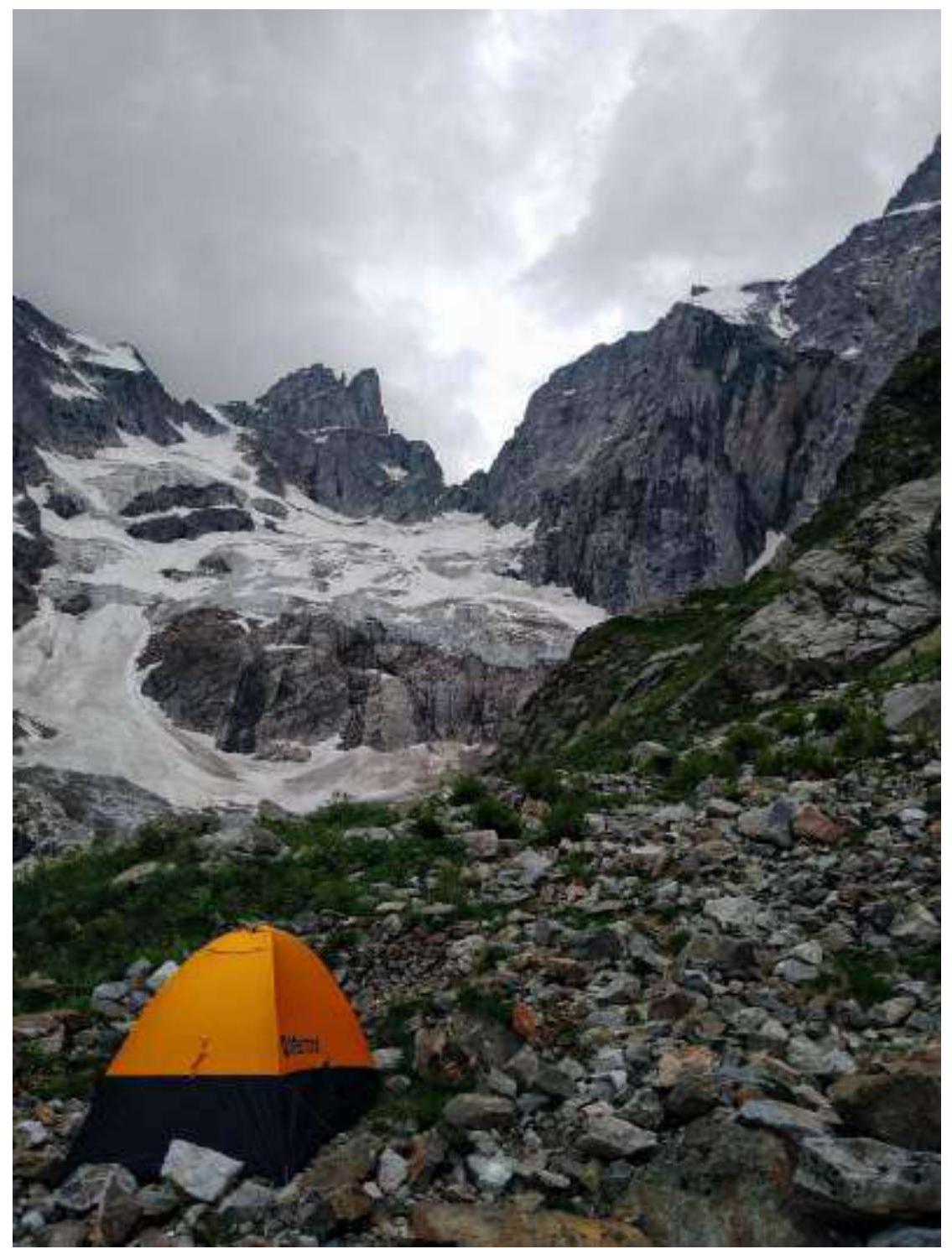
Photo #1 — Overnight stay in the "green pocket"
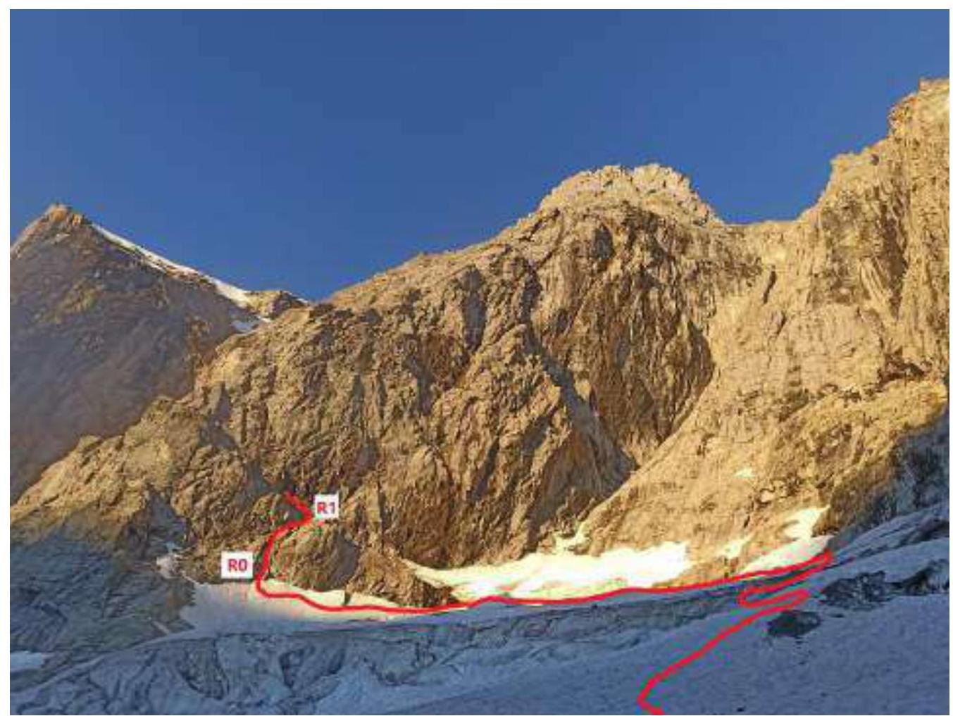
Photo #2 — Approach along the glacier and start of the route R0–R1
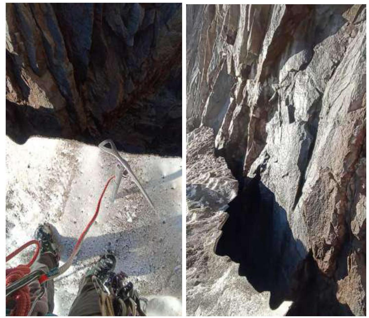
Photo #3 — Randkluft at the start of the route. From this point, we moved left and set up R0.
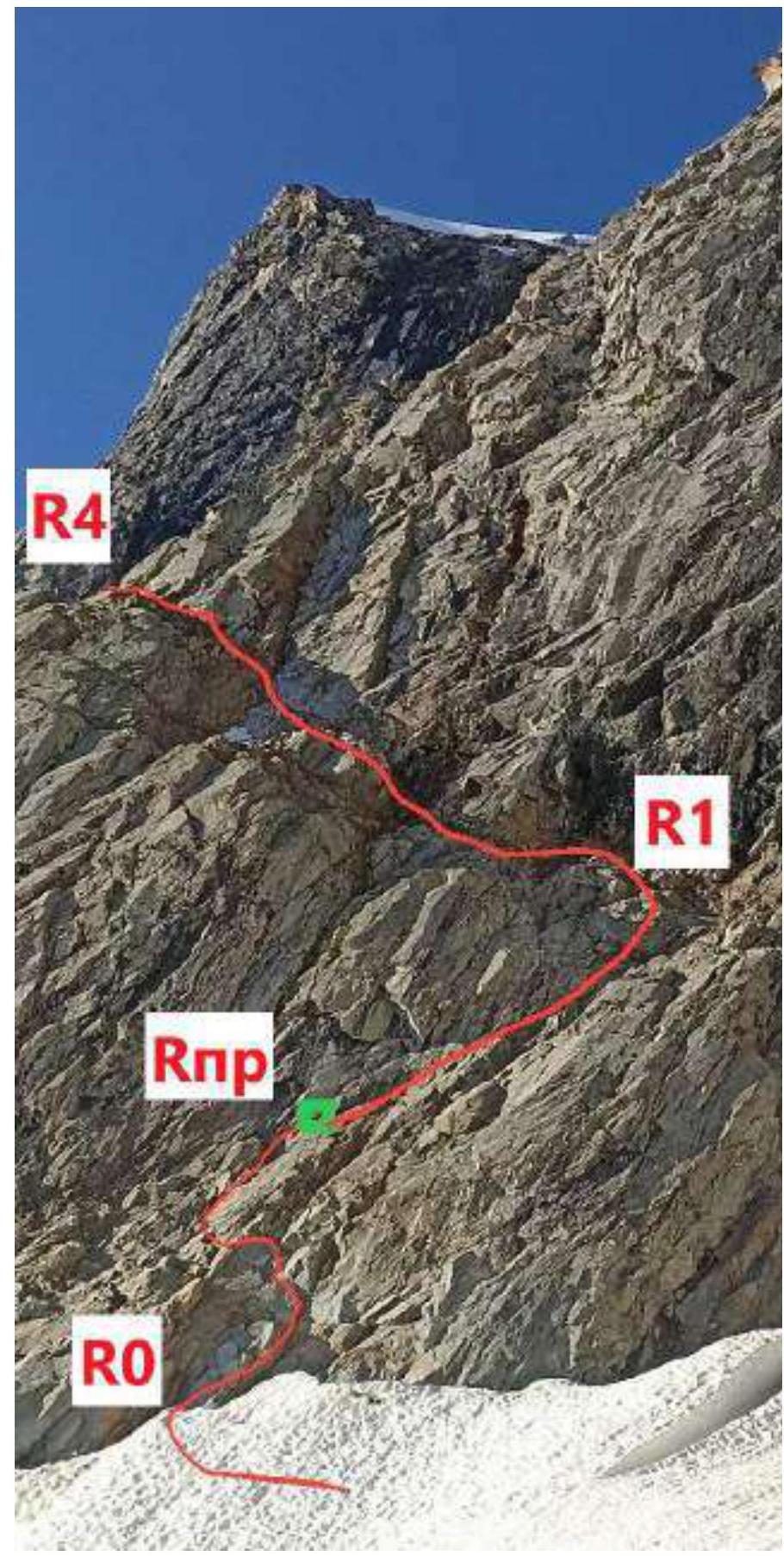
Photo #4 — R0–R1 section. Location where we set up an intermediate station Rпр.
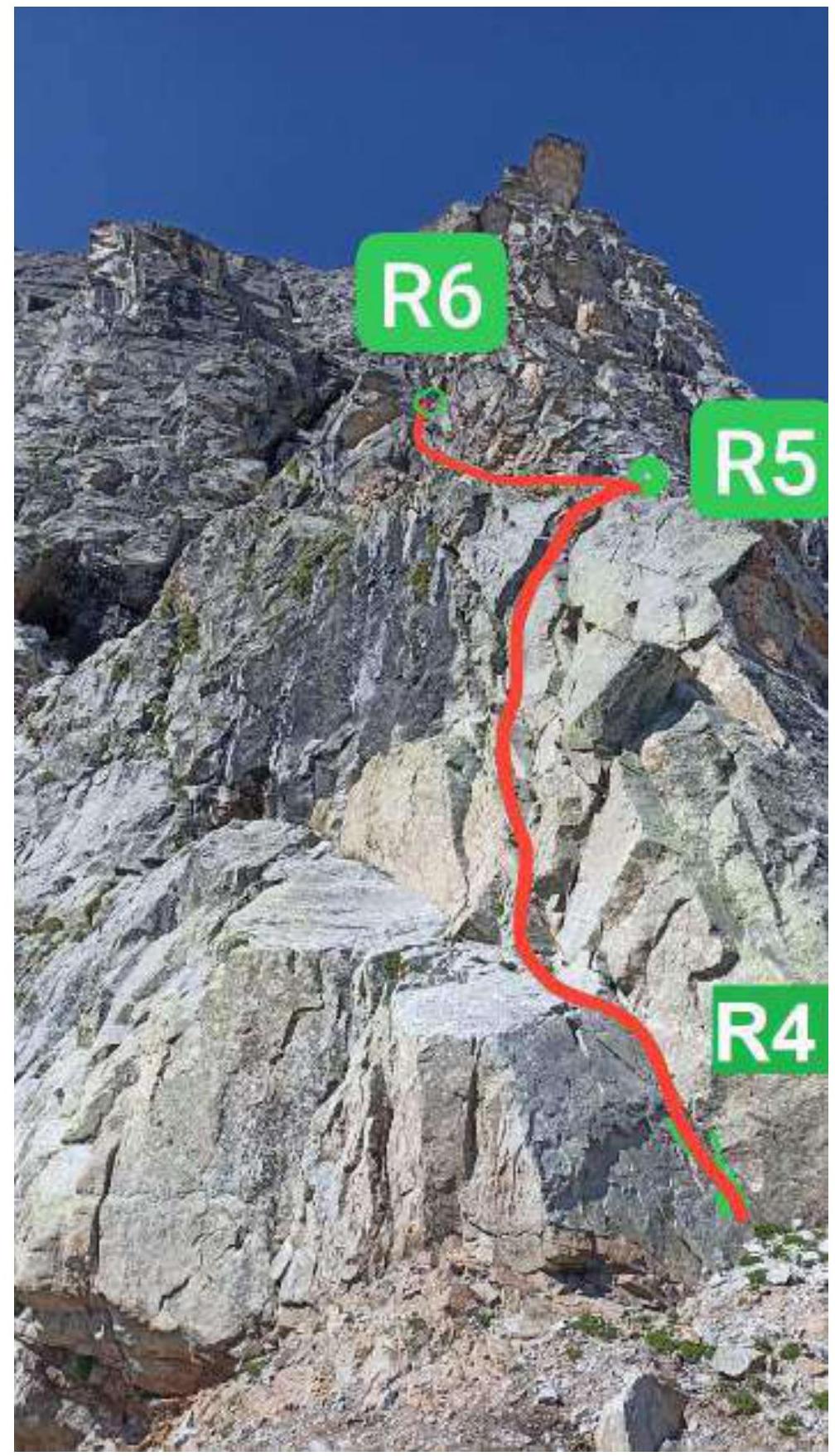
Photo #5 — R4–R5–R6 section. The belay post is visible against the sky.
Photo #6 — R6–R7. Long green internal corner

Photo #7 — R7–R8. Ahead is the bypass of the belay post upwards to the right.
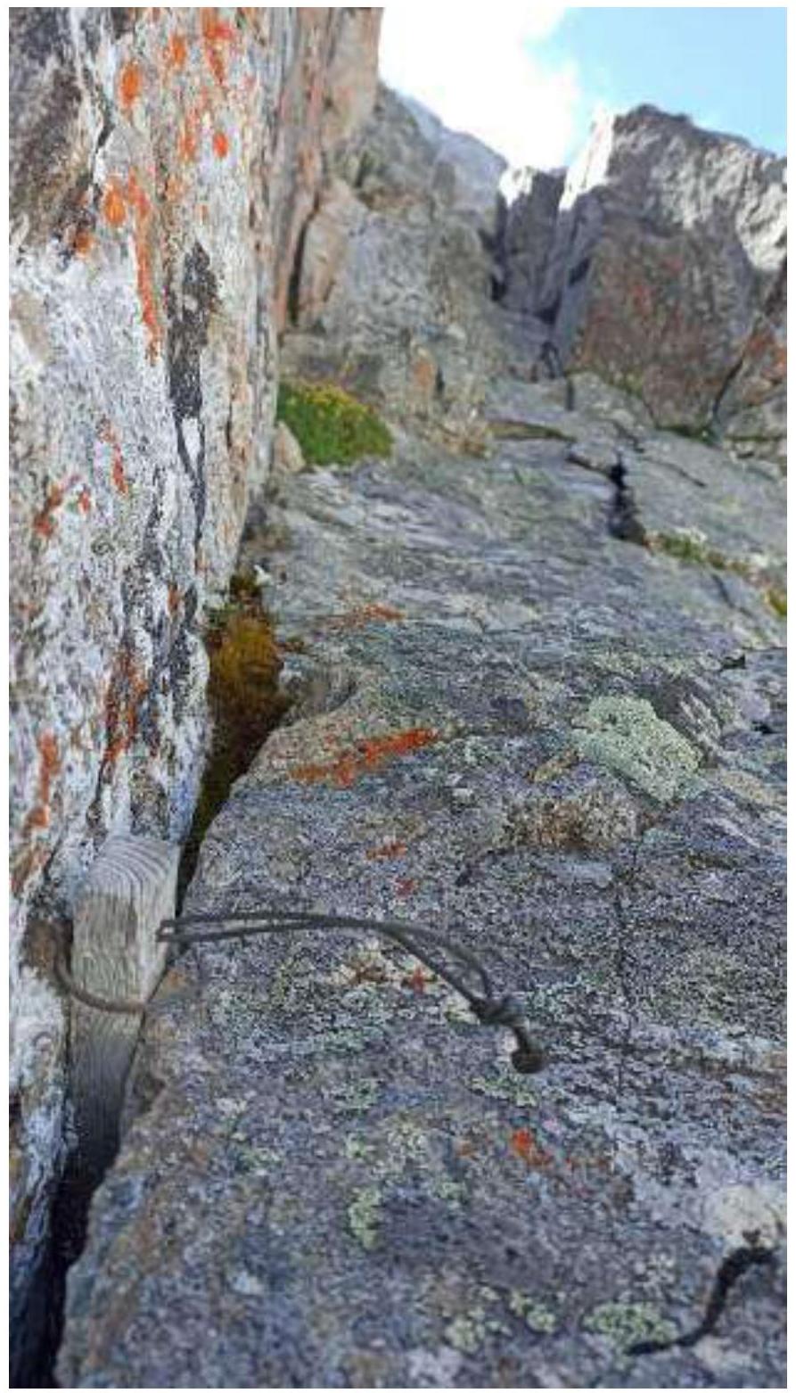
Photo #8 — R8–R9. Bypass of the belay post along inclined slabs. Straight up.
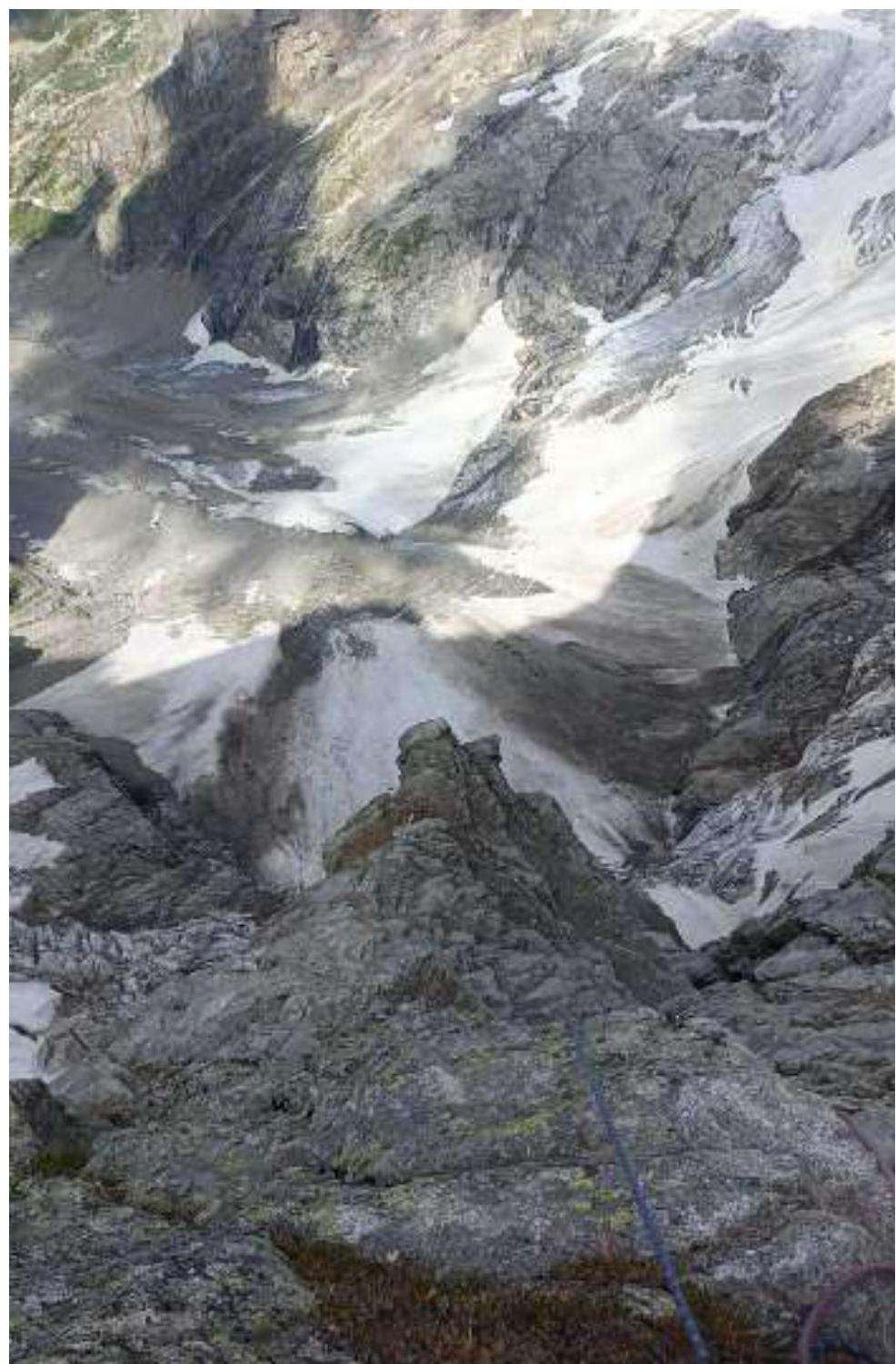
Photo #9 — R9–R10, view from above. Below is the saddle between the belay post and the NE ridge.
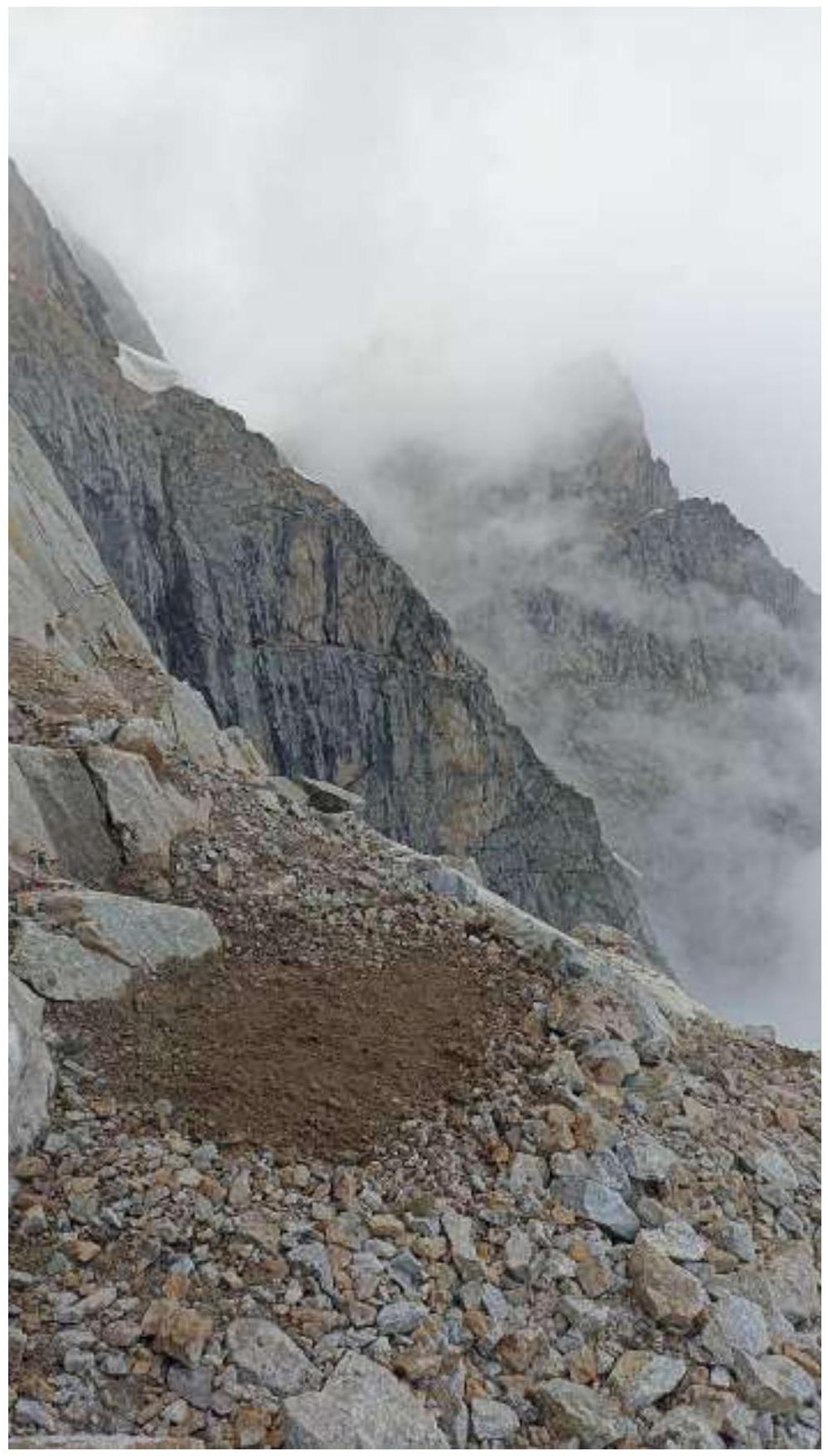
Photo #10 — R14. We leveled the platform. There is a snow patch nearby.
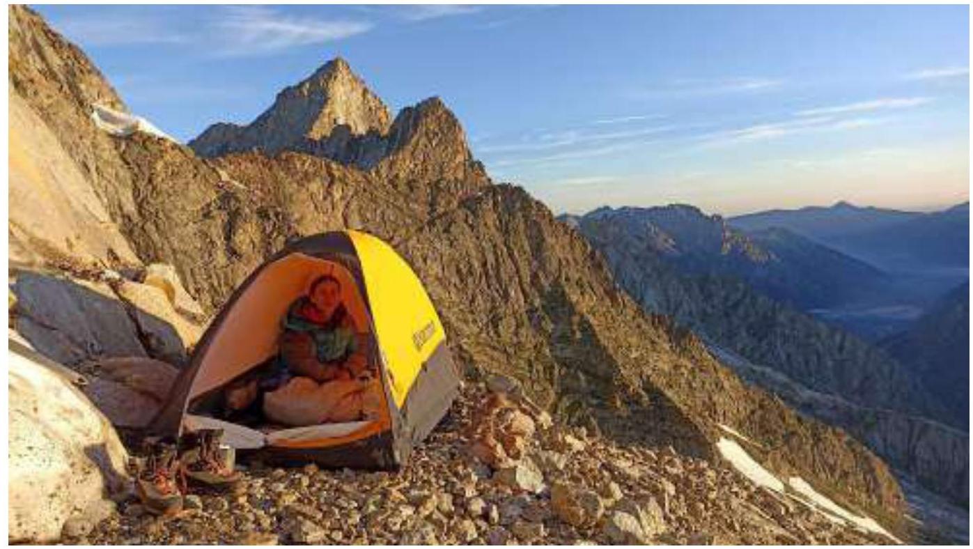
Photo #11 — Overnight camp of the team on R14
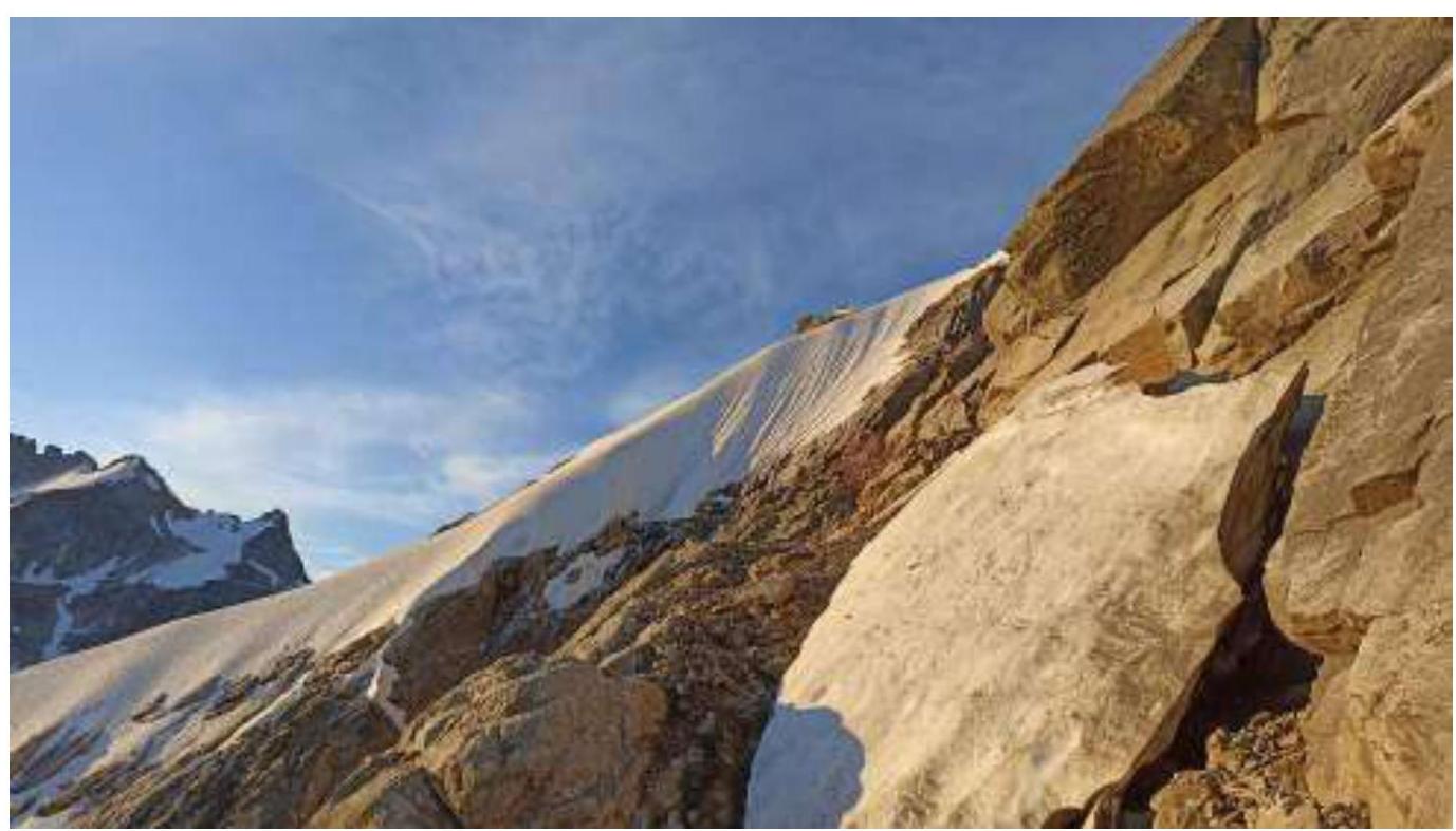
Photo #12 — R14. Snow patch opposite the tent. Behind it, the snow knife is visible.
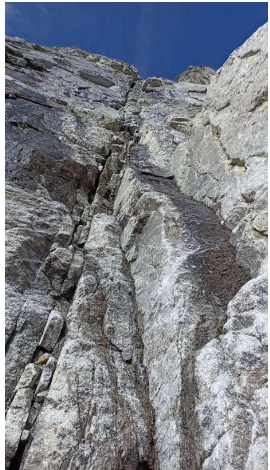
Photo #13 — R16–R17
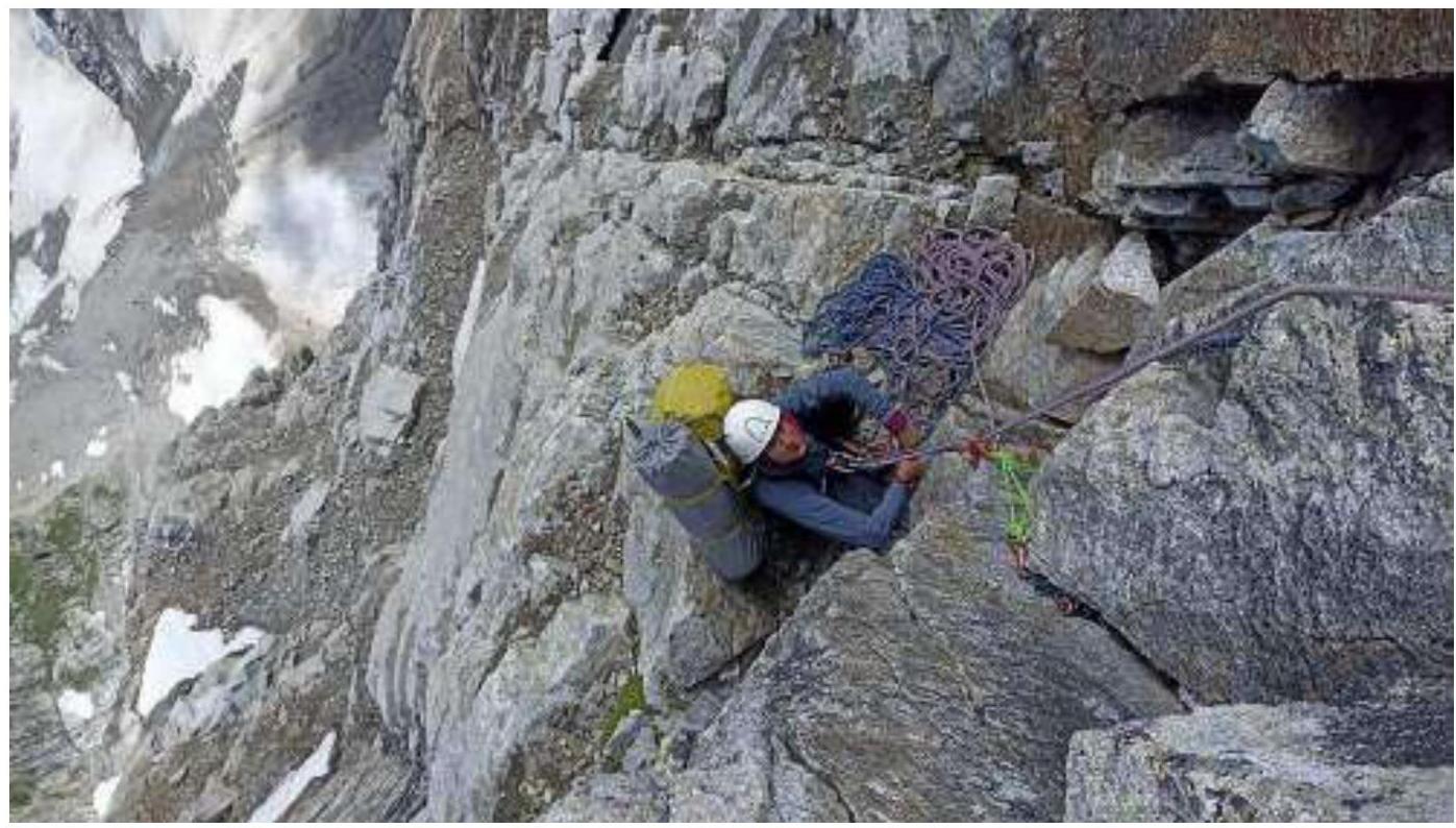
Photo #14 — Station R17
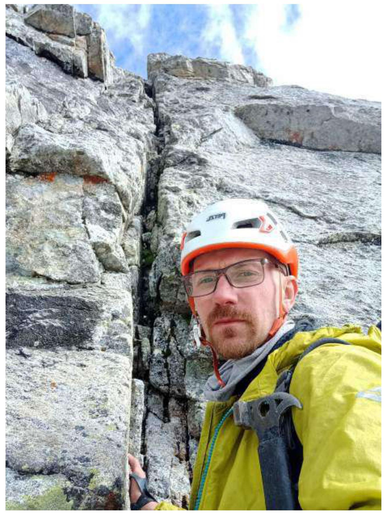
Photo #15 — Leader on R17–R18
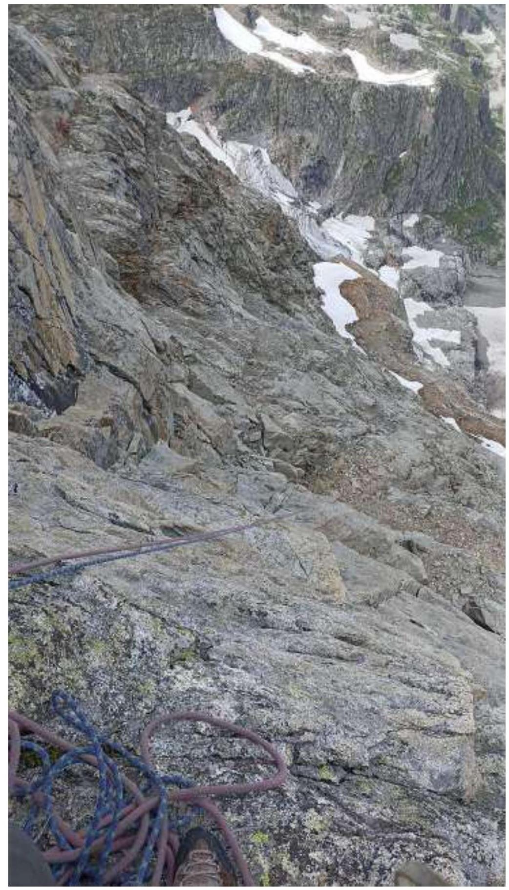
Photo #16 — View from R22. Further begins a complex approach to the base of the corner-chimney. ![img-
Comments
Sign in to leave a comment