For the championship of the Central Council of the Spartak Voluntary Sports Society in the category of technically complex ascents.
DALAR PEAK
via the western wall
Team of the Spartak CS DSS Alpine Camp "Uzunkol"
| Korablin B. N. | — team leader |
|---|---|
| Belyaev Yu. S. | — deputy team leader |
| Korshunov D. M. | — team member |
| Paunksnis R. A. | — team member |
1968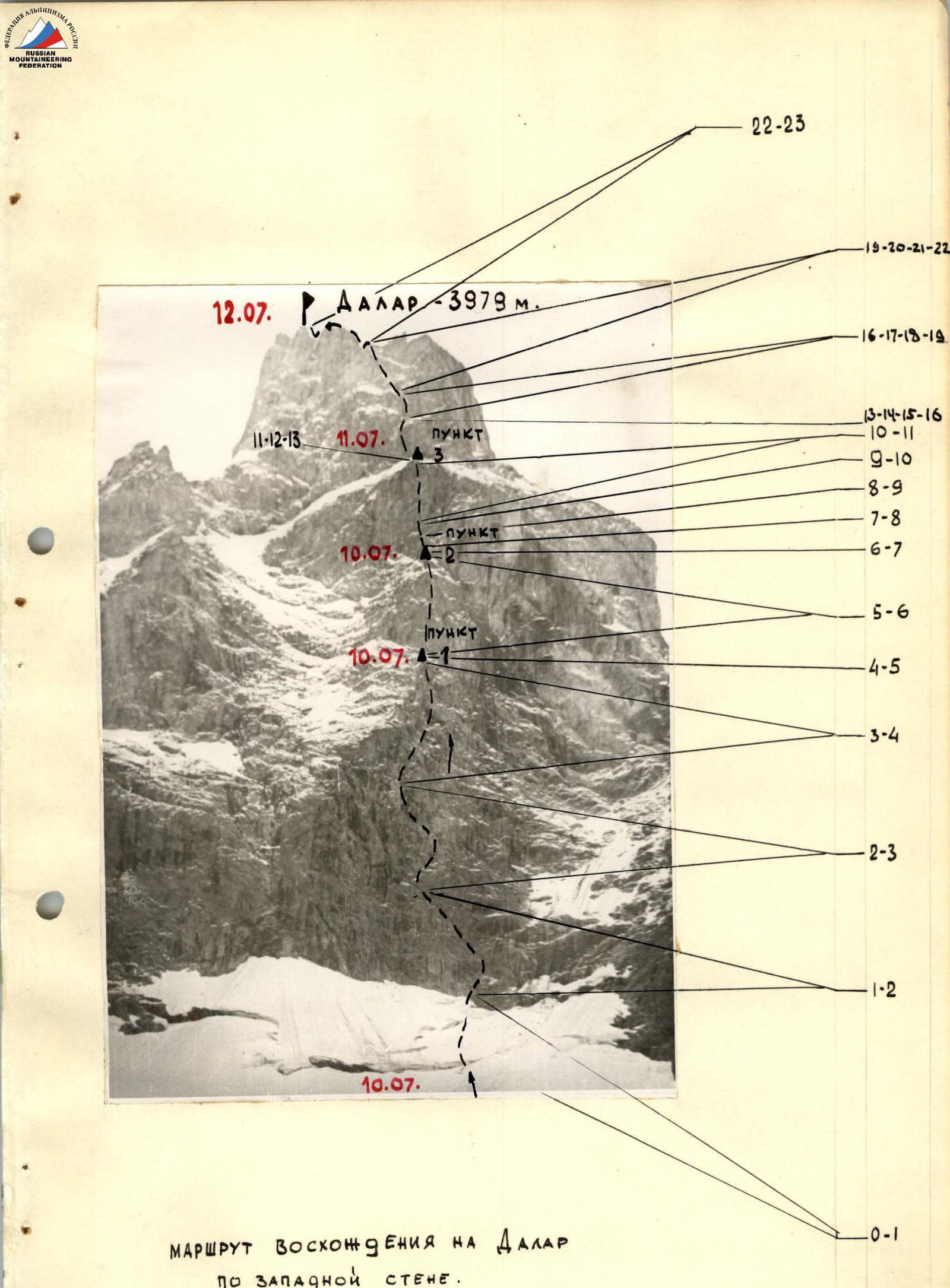
- The composition of the assault group is as per the application.
According to the application, the initial group composition was as follows:
Main roster:
Korablin B. N. — team captain and ascent leader Belyaev Yu. S. — deputy leader and coach Grakovich V. F. — team member Zakharov P. P. — team member
Reserve roster:
Korshunov D. M. Paunksnis R. A.
As a result of route reconnaissance and assessment of its feasibility, it was decided to proceed with the entire declared team rather than just four members.
Immediately before departing for the route, unforeseen circumstances not only prevented the entire team from starting the ascent but also necessitated changes to the main roster by including reserve members.
Grakovich V. F. was unable to participate due to a leg injury sustained during a training session on the rocks with the team.
Zakharov P. P. had to leave the camp to meet a Czechoslovakian alpine delegation arriving outside the previously agreed-upon dates.
6. Route progression.
On July 15, 1968, the team departed from the "Uzunkol" alpine camp and followed the Myrd valley to reach 1500 m on the Dalar glacier plateau, where pre-deposited equipment, tents, and supplies were hidden.
Upon setting up camp, the team began:
- sorting and preparing equipment,
- packing backpacks.
In the fading light, the entire wall was clearly visible, allowing for a visual assessment of the route.
By evening, cumulus clouds had appeared from behind Dalar. However, there were no immediate signs of drastic weather changes.
At 20:30, the last lights on the bivouac of the dischargees on the opposite side of the Myrd valley went out — they were set to begin their own ascents in the same area the next day.
July 10, 1968. Early rise. The Korshunov-Paunksnis rope team began navigating the bergschrund at 4:00 and processing the exit from it. By 4:40, the Korablin-Belyaev rope team joined in. The group reunited at the base of the wall. After a brief rest, the first rope team led the ascent.
The initial ledge appeared to divert from the wall and the direct ascent line. However, this was deceptive, as it eventually rejoined the wall. The ledge's terrain occasionally allowed for protection through rock outcrops — more accurately described as slabs or flakes. Pitons were used from the start. Soon, they reached the end of the ledge and constructed a control cairn.
From there, the route traversed diagonally to the right and upwards onto the "axial" line of the route.
The rope teams proceeded independently, with Korshunov and Paunksnis still leading.
The rock structure was intriguing, resembling a mix between "ram's foreheads," boulders, and wavy slabs, all at a steep angle of not less than 60°. Few cracks were present, necessitating the use of wedges. Wider cracks and fissures were more common.
The path across the "waves" led to an internal corner with an overhanging cork. Here, the difficulty level increased significantly, requiring the rope teams to work in alternation. Thin pitons were employed due to the scarcity of cracks. Overcoming the cork required constructing a "living ladder." Korablin, being the heavier, provided a base for the others, allowing them to reach the top of the cork.
The rope teams continued in alternation towards the designated "point No. 1." The weather began to deteriorate, with snow expected. Despite the desire to push on, the conditions were not favorable.
Upon traversing a 45-meter inclined slab, it became clear that the hopes for better weather were premature — wet snow began to fall, and water streamed down the rocks. The rocks above were covered in ice, presenting an unpleasant prospect.
Following the traverse, another interesting rock formation appeared — a wall with a steepness of over 75°, composed of slabs with reverse slopes. All pitons were hammered under the slabs, as other cracks were virtually nonexistent. The climbing was strenuous, and ladders were eventually used. On certain sections of this 150-meter wall, backpacks were pulled up using ropes. The intensity of the work indicated that more serious challenges lay ahead.
In the upper part of this wall, the relief of slabs and blocks became more pronounced, with the steepness remaining unchanged. The first overhanging sections appeared, although they were not significant. Climbing such rocks in good weather would be enjoyable, but the conditions were far from ideal, with a thin ice crust covering the rocks. Those below faced even worse conditions, with snow, water, and ice fragments falling from above.
The tempo of movement slowed noticeably.
The upper edge of this wall was still not visible, but the elapsed time indicated that the predetermined "point No. 2" should be nearing.
Gusts of wind and wet snow took their toll: wet clothing restricted movement, and fingers frequently needed to be warmed in the mouth, as woolen gloves were too slippery on icy rocks.
Despite the challenges, the group progressed steadily, rope team by rope team. The terrain suggested that the initial hopes for a ledge at "point No. 2" were unlikely to be fulfilled.
The passage of time was not immediately apparent due to the intense work, but fatigue and dwindling personal rations indicated that the ascent had been ongoing for a considerable and strenuous period.
It was not until dusk that the group realized the first ledge they encountered would serve as their bivouac site. Equipment was hung on pitons, and a tent was stretched downwards, resembling a large sack. The first team to settle in for the night lit a primus stove to prepare dinner.
Each member took turns holding the primus, warming themselves and drying some of their wet gear and clothing.
Attempts to spot the lights of dischargees' bivouacs through breaks in the clouds were unsuccessful — the clouds densely filled the valley.
The night was marked by attempts to find a more comfortable spot to lie down. The weather remained poor throughout the night, with wind, snow, and more wind.
July 11, 1968. The first rope team, Korablin and Belyaev, departed upwards in the morning. The remaining team members were tasked with dismantling the bivouac, removing all pitons that had held various equipment, safety lines, and tent attachments.
Once they had fully extended the rope, they too moved upwards.
The first significant obstacle of the day was a steep snow-ice gully. Ice fragments were dislodged, necessitating the cutting of steps. The sound of hammering echoed as shlammbur pitons were used. The gully's walls had few cracks, requiring the use of shlammbur pitons for protection in the middle section. This was a very tense section. The second rope team followed the first on the rope and began advancing along an inclined, ice-covered ledge towards a massive internal corner formed by a virtually vertical monolithic slab.
This section of the route confirmed that the overall difficulty had not been overestimated. It was clear that the ascent would be much calmer in dry, good weather, but the complexity would remain.
The corner appeared to be overhanging, and the subsequent path was not visible, making it seem very long.
They traversed 15 meters of the corner using ladders and pitons spaced 2.5–3 meters apart, with backpacks being pulled up. Immediately after the corner, a 45-meter equally smooth and vertical wall began without transition or easing. The entire section was traversed using ladders, with backpacks being pulled up on ropes.
Water continued to flow down the rocks, snow fell, and ice fragments were dislodged from the rocks.
Upon completing this section, a new complex section awaited — an inclined, diagonal traverse to the right across an 85° slab with micro-cracks under a massive 60-meter monolithic wall. Of these 60 meters, 35 required the use of ladders. The numerous training sessions on complex rocks and "races" with ladders were recalled with appreciation.
By 18:00, they reached "point No. 3." A heavy snowfall from wet snow accompanied them throughout the day, and attempts to dry their thoroughly wet clothes were unsuccessful. The wind and snow added more water to their already soaked boots, down jackets, and other gear.
They set up a tent on the ledge, hoping that a good rest would refresh them. However, the night brought no relief, with strong gusts of wind and cold preventing sleep.
July 12, 1968. At 6.00, they packed up the bivouac and departed along monolithic, large-blocky rocks under a steep wall. The conditions remained unchanged — wind, snow, and rocks covered in a thin film of ice, with ledges and holds covered in ice nodules and snow.
The sight of the negative wall did not inspire optimism. Bypassing it was too harsh and unpleasant, especially under the current weather conditions. The search for a bypass was brief. The only viable option was to traverse the wall and move rightward along a slab that had broken off.
The enormous slab, held by its lower edge to a ledge or fissure, stood along the wall. Climbing onto its upper edge initiated a tense moment — traversing along the narrow edge of the slab, which was only 5–7 cm wide and stood 70 cm away from the wall.
Korshunov's attempt to traverse "on top" of the slab's edge was unsuccessful. Everyone proceeded directly along the top, balancing on the narrow edge.
However, this traverse did not significantly alter their situation — they still needed to navigate a corniche, followed by another steep wall. The corniche was passed using ladders. Beyond the corniche, another 10 meters of wall remained, followed by a traverse to the left and upwards, although significantly gentler at 70°.
In the middle of this traverse, a small challenge arose — transitioning from one outcrop to another, requiring the use of ladders again. The relief of this section indicated that there would be no easing of the climbing difficulty. Indeed, beyond the traverse, they encountered an inclined ledge with a 65° angle. The rocks were covered in ice, and the wall above the ledge had almost no cracks or holds. Three shlammbur pitons were hammered in, followed by the discovery of a few cracks for regular pitons. Climbing on ladders resumed, with legs sometimes not having a secure foothold on the "ledge," necessitating the hanging of ladders.
This traverse led to another нависающие скалы (overhanging rocks) composed of massive blocks. However, a fissure ran through the center of this нависание, providing a passage. The 15-meter overhang required meticulous protection — 5 regular and 3 shlammbur pitons.
A subsequent ledge provided a brief respite before an almost vertical internal corner.
Beyond this corner, the rocks of the summit ridge became visible, instilling confidence that they could reach the summit and begin their descent that day. By this point, it was around 1 pm. The large gaps in the clouds added to their optimism. The snowfall had ceased earlier.
The final wall before the summit ridge presented a significant challenge. A 60-meter wall stood before them like a single slab, with bypass options on either side appearing untrustworthy. They spent over two hours on these final 60 meters.
The rocks beyond the slab seemed almost easy by comparison, and the last 15 meters, although steep, were traversed relatively simply. Upon reaching the ridge, they quickly organized a rappel and continued towards the summit.
This section was familiar to each of them, as several routes led to the summit ridge.
On the summit, they left a note and consumed some food — the cold, piercing wind from the south was relentless. They then began their descent via the 3B category of difficulty route.
The descent revealed the true nature of the route, with various loops of reepschnur marking sections where they had never been hung before. All rocks, ledges, and gullies were filled with snow.
After descending to a large ledge — roughly halfway down the descent route — they unanimously decided to continue down to the plateau, where a dry tent and warm rest awaited. They executed this plan. The final descent from the pass was made in darkness, but with headlamps, it posed no practical issue. They arrived at their original bivouac site at 22:00, completing the cycle. The desire was solely to sleep.
July 13, 1968. The morning brought good weather and sunshine, prompting the question of whether the previous day's weather had truly occurred.
Without haste, they dismantled the bivouac and began their descent to the camp. The dischargees had departed for the camp the previous day after their own ascents and responded to the team's final signal, confirming everyone's safety.
The "official" conclusion to their ascent was marked by a formation in the lineup at their home camp, "Uzunkol."
Table of main ascent characteristics for Dalar Peak
via the western wall
Route length — 979 m, including the most complex sections — 420 m. Average steepness — 70°, including the most complex sections — 105°.
| Date | Section | Steepness, ° | Length, m | Section characteristics and method of overcoming | Protection | Weather conditions | Bivouac stops | Time taken, h | Pitons (rock/shl.) |
|---|---|---|---|---|---|---|---|---|---|
| 10.07 | R0–R1 | 50 | 90 | Snow slope with bergschrund. Simultaneous. | Through ice axe | good | 1:30 | — | |
| 10.07 | R1–R2 | 45–65 | — | Inclined ledge with overhangs, step-like rocks with reverse slope. Alternating, medium-difficulty rocks. | Pitons, outcrops | — | 5:50 | 1:00 | 6/— |
| 10.07 | R2–R3 | 60 | 100 | Zigzag internal corner composed of slab-like rocks, "ram's foreheads" — with overhangs. Difficult rocks, minimal or no cracks and holds. | Pitons | — | 6:30 | 3:00 | 12/— |
| 10.07 | R3–R4 | 60 | 60 | Rocks resembling "ram's foreheads" — wavy. Cracks like short, blunt splits. Difficult climbing, minimal cracks for attachment and protection through outcrops. (Point No. 1) | Pitons, outcrops | Weather starts to deteriorate by 8:00 | 9:30 | 1:30 | 12/— |
| 10.07 | R4–R5 | — | 45 | Traverse along an inclined step-like ledge along the edge of snow and rocks. Alternating, rocks covered in ice. | Pitons | Snowing | 10:30 | 0:30 | 2/— |
| 10.07 | R5–R6 | 75 | 150 | Slabs with reverse slope. Ascent of rounded rock blocks. Movement towards a large fissure. Very difficult climbing. Icy rocks. 45 m traversed on ladders. (Point No. 2) | Pitons | Snowing, gusty wind | 11:00 | 9:00 | 32/— |
| 11.07 | R6–R7 | — | 20 | Traverse rightwards towards a gully. Medium-difficulty rocks. | Pitons, outcrops | Very cold, snowing, strong wind. | 7:00 | 0:15 | 2/— |
| 11.07 | R7–R8 | 45 | 30 | Snow-ice gully. Cutting steps, pitons into the gully walls. | Pitons | — | 7:15 | 1:30 | 5/2 |
| 11.07 | R8–R9 | — | 30 | Traverse leftwards along an inclined ledge (45°) along the edge of snow and rocks towards an internal corner. Medium-difficulty rocks. | Pitons | — | 8:45 | 0:30 | 3/— |
| 11.07 | R9–R10 | 80 | 60 | Internal corner — 15 m and smooth wall 45 m. Very difficult climbing. Entire section on ladders. | Pitons | — | 9:15 | 5:00 | 20/— |
| 12.07 | R10–R11 | 85 | 10 | Traverse along a smooth wall under a corniche towards a massive vertical slab. Very difficult climbing. | Pitons | Very cold, snowing. | 14:15 | 0:30 | 3/— |
| 12.07 | R11–R12 | 85 | 60 | Direct ascent up a massive slab resembling a wall. Very difficult climbing, micro-holds. 35 m traversed on ladders. | Pitons | Wind, snow, icy rocks. | 14:45 | 2:15 | 18/— |
| 12.07 | R12–R13 | 85 | 30 | Upper part of the slab — rightwards to a narrow ice gully and upwards onto a wide snow ledge. Very difficult and tense climbing. Backpacks pulled up. (Point No. 3) | Pitons | Fog, wind. Rocks thawing. | 17:00 | 1:30 | 12/— |
| 12.07 | R13–R14 | 70 | 40 | Large-blocky rocks, traversing towards a detached slab under a corniche. Medium climbing. | Pitons, outcrops | Fog, cold wind, icy rocks. | 6:00 | 0:30 | 3/— |
| 12.07 | R14–R15 | 105 | 12 | Traverse along a detached slab under a corniche, the slab being a large outcrop from the wall, 0.5–0.7 m wide at the base and 5–7 cm at the top. Height over 30 m — movement towards the corniche. Very difficult climbing, ladders, support. | Pitons | — | 6:30 | 1:00 | 8/— |
| 12.07 | R15–R16 | 105–90 | 15 | Overcoming the corniche. Ascent up the wall. Entire section on ladders. Backpacks pulled up. | Pitons | Cold wind, icy rocks, clearing. | 7:30 | 1:30 | 10/— |
| 12.07 | R16–R17 | 70 | 30 | Steep traverse rightwards and upwards along a 60° inclined ledge. Slick rocks. Very difficult climbing. | Pitons | — | 9:00 | 1:00 | 4/— |
| 12.07 | R17–R18 | 60 | 30 | Section of wall with steeply inclined, narrow ledges filled with snow. Tense climbing. | Pitons | — | 10:00 | 1:30 | 4/3 |
| 12.07 | R18–R19 | 95 | 12 | Overhanging rocks. Fissure leading to a snow-ice ledge. Difficult climbing. One ladder. | Pitons | — | 11:30 | 1:30 | 5/8 |
| 12.07 | R19–R20 | 80 | 10 | 10-meter internal corner and 10 meters straight up the wall under an overhanging block. Very difficult, strenuous climbing. | Pitons | — | 13:00 | 0:45 | 6/— |
| 12.07 | R20–R21 | 65 | 60 | Slab under an overhang and upwards-left at 45° along a smooth wall to its upper edge. Difficult climbing. Small cracks. Ladders. | Pitons | — | 13:45 | 2:00 | 12/— |
| 12.07 | R21–R22 | 60 | 15 | Straight up along broken rocks onto the main ridge of the peak. Medium difficulty. | Outcrops | Cold wind, clear. | 15:45 | 0:30 | — |
| 12.07 | R22–R23 | 15 | 45 | Summit ridge and through a pass to the summit at 17:15. Easy climbing. | Outcrops | Cold wind, clear. | 16:15 | 0:30 | — |
Footnotes
-
DALAR ASCENT ROUTE VIA THE WESTERN WALL. ↩
