
Route Passport
-
Western Caucasus, Dombay, section number according to KMGV 2.2.
-
Dombay Western 4036 m via the counterfort of the South wall.
-
6A category of difficulty, first ascent.
-
The route is rock.
-
The height difference of the route is 1036 m (by altimeter).
Route length 1715 m. Length of sections with V category of difficulty 255 m. Length of sections with VI category of difficulty 75 m. Average steepness: main part of the route 80°, total route 55°.
-
Hooks left on the route: total 4; bolted 0.
Used in total on the route:
- rock hooks 69 (6)
- protection elements 142 (3)
- bolted hooks 0 (0) (free climbing / ITO)
-
Team's working hours: 42; 5 days.
-
Team leader: Gubanov R.Yu., CMS.
Participants:
- Eliseev A.A., 1st sports category
- Aliev R.Kh., 1st sports category
- Foigel M.R., 1st sports category
-
Coach: Shipilov V.A.
-
Departure to the route: June 13, 2004.
Summit reached: June 18, 2004. Return to base camp: June 20, 2004.
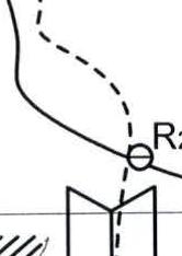
Route Photograph

The upper part of the routes is not visible in the photograph.
- O. Kosmachev's route, 1960, 5B
- M. Zagirnyak's route, 2000, 6A (N. Khubieva 1975)
- R. Gubanov's route, 2004, 6A (completed by our team)
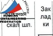
Area map
Team's Tactical Actions
The tactical plan was built based on the consultations received about the object of ascent and visual assessment of the route's nature and complexity. Provision with equipment and food was calculated for worsening weather conditions. Equipment was also selected taking into account a sharp deterioration in weather, including the need for the first climber to work on icy sections with crampons. The set of technical means included: rock hooks, various protection elements, "sky hooks", and hook-nuts. In case of unforeseen situations, there was a drill with a set of bolted hooks. Throughout the entire route, the first climber worked with a minimally possible weight backpack. The rest moved along the fixed ropes, carrying their backpacks or attaching them to their harnesses.
To increase the reliability of belays, movement along the route was carried out on a double rope. All participants, except the first, moved along the fixed ropes with top-rope belay. The first climber went on a double rope, one of which meets all UIAA requirements. Although any team member can be the first climber, it was decided not to change the leader during the working day. This saves time and increases safety. During the ascent, the leaders were: Eliseev A., Gubanov R., Aliev R., Foigel M.
Radio communication with Dombay's EMERCOM rescue team was maintained using a "MOTOROLA" radio station.
The group left Dombay settlement on June 13, 2004, at 10:00. The first bivouac was set up at the "Through" night camps. The next day, they approached the route, spent several hours on the final choice of the path, and observed the ascent path. On the same day, they worked for 4 hours and set up a night camp on a snowy ridge. On June 15, at 12:00, they approached the first key section, the pair Gubanov - Eliseev continued working on the route, while the rest set up a bivouac. Not much was accomplished that day, as it rained in the second half of the day.
June 16:
- Passed the first bastion.
- Spent the night on the ridge of the counterfort.
June 17:
- Weather deteriorated.
- Started working late, only approached the second key section by 17:00.
- Set up a night camp under the wall.
June 18:
- Passed the second bastion.
- By 16:00, reached the main ridge of the Dombay massif.
- On the same day, climbed to the summit.
- Spent the night on the ridge.
June 19:
- Weather deteriorated.
- By 19:00, the group descended to the "Through" night camps.
The next day, they descended to Dombay settlement.
A sufficiently complex first ascent in all respects was completed by the team safely and with a sufficient margin of safety.


| Section # | Length, m | Steepness, ° | Difficulty | Note |
|---|---|---|---|---|
| 1 | 25 | 65 | IV | |
| 2 | 25 | 80 | V | |
| 3 | 45 | 80 | V | |
| 4 | 150 | 50 | III | |
| 5 | 200 | 60 | IV | |
| 6 | 20 | 85 | VI | |
| 7 | 10 | 90 | VI A1 | |
| 8 | 15 | 90 | VI | |
| 9 | 45 | 80 | V+ | Uncomfortable station in a crack under an overhang. Move down to the right from it behind the corner. |
| 10 | 50 | 65 | IV | |
| 11 | 45 | 70 | IV+ | |
| 12 | 45 | 60 | IV | |
| 13 | 25 | 90 | VI | |
| 14 | 20 | 90 | V | |
| 15 | 35 | 45 | III | |
| 16 | 45 | 70 | IV+ | |
| 17 | 350 | 50 | III | |
| 18 | 35 | 70 | V | |
| 19 | 10 | 70 | IV | |
| 20 | 35 | 70 | V | |
| 21 | 10 | 60 | IV | |
| 22 | 5 | 90 | VI A1 | |
| 23 | 25 | 80 | V | |
| 24 | 5 | 80 | V | |
| 25 | 30 | 50 | III | |
| 26 | 30 | 80 | V | |
| 27 | 15 | 80 | V | |
| 28 | 400 | 40 | III |
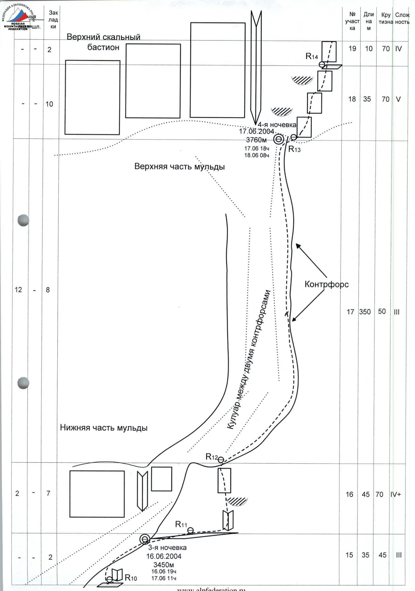
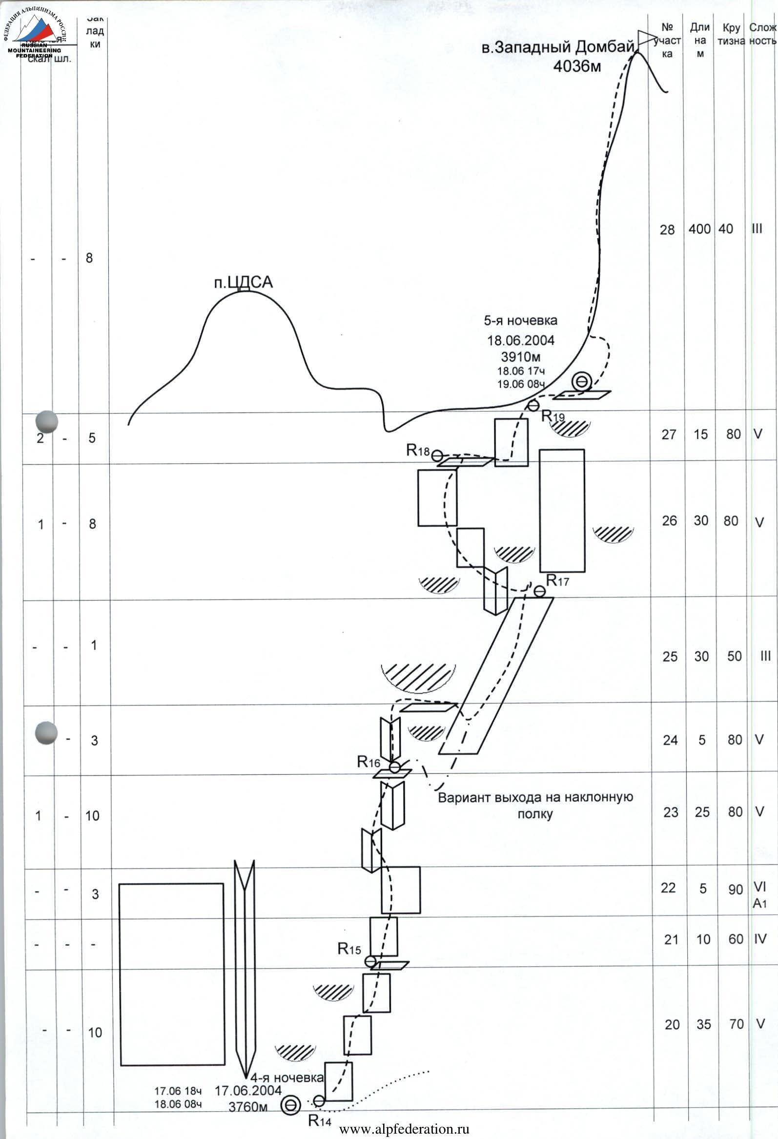
Route Description by Sections
The route approximately starts along internal corners, slightly to the right of where the gentle "paw" of the counterfort turns into the rock massif. This is the simplest way to reach the ridge of the "paw"; the path is limited on the left by the overhangs of the massif and on the right by the complex walls of the "paw".
R0–R1. Along a small wall, cut by a vertical crack, exit to an inclined shelf 25 m IV category of difficulty, from it - to an internal corner that starts from the shelf. Move along the right part of the corner, then along the rocks to the right of the corner 25 m V category of difficulty (50 m, 65–80°, IV–V).
R1–R2. Up along small walls to an internal corner and along its right part, exit to a small depression in the ridge of the "paw" 45 m V category of difficulty (45 m, 80°, V).
R2–R3. Further along simple rocks of the lower part of the counterfort approximately 150 m III category of difficulty to a slight flattening. There's a place for a night camp. From here, the steepness of the counterfort and its complexity increase slightly (150 m, 50°, III).
R3–R4. From the night camp 200 m IV category of difficulty up along the rocks of the counterfort of medium complexity to a large inclined shelf, from which the first rocky bastion begins. There's a place for a night camp (200 m, 60°, IV).
R4–R5. Along the light-brown wall, which is located slightly to the left of the previous direction of movement, complex climbing 20 m up VI category of difficulty, then 10 m VI category of difficulty A1 up and to the right towards the beginning of a small internal corner with a vertical crack. The relief is monolithic, there are few footholds. Then along the rocks to the right of the corner up 15 m VI category of difficulty to a small niche-crack under an overhang. Along this niche 2–3 m down and to the right behind the bend of the relief to a comfortable ledge at the base of the internal corner (45 m, 85–90°, VI A1).
R5–R6. Along the wet internal corner to a small ledge, then again along the internal corner. Climbing is tense, rocks are washed with water. Exit from the corner through a small cornice (passed in the left part) to a wide internal corner and from it a simple exit to the left onto a shelf (45 m, 80°, V+).
R6–R7. Along shelves and a simple internal corner up and to the right 50 m IV category of difficulty (50 m, 65°, IV).
R7–R8. Along shelves and slabs, bypassing small overhangs and vertical sections to the right, to a wide internal corner under an overhang 45 m IV+ category of difficulty (45 m, 70°, IV+).
R8–R9. From the internal corner along an inclined shelf up and to the left, and then up and to the right, bypassing the overhang 45 m IV category of difficulty (45 m, 60°, IV).
R9–R10. Along the wall up and to the right under overhangs towards a vertical crack and along it through the overhang 25 m VI category of difficulty. Then along walls with vertical cracks 20 m V category of difficulty up to a niche with a ledge (45 m, 90°, V–VI).
R10–R11. From the niche to a simple ridge and along it to the rise of the counterfort 35 m III category of difficulty. There's a place for a night camp (35 m, 45°, III).
R11–R12. The rise is overcome in the right part, along internal corners and small walls 45 m IV category of difficulty, exit to a gentle section of the counterfort. The relief is destroyed. In the absence of snow, a more straightforward path will be bypassing the rise along the slabs on the left, from the side of the couloir between the counterforts (45 m, 70°, IV).
R12–R13. Along a simple counterfort 350 m III category of difficulty to the upper bastion of the wall. There's a place for a night camp (350 m, 50°, III).
R14–R15. From the place where the right edge of the depression leads under the wall, descend slightly to the right behind the bend and along the system of walls up and to the right (35 m, 70°, V).
R15–R16. From the station along a ledge to the right, then up to a small wall with a crack (the crack is wide, forms a crack), climbing is very difficult using ITO (5 m, 90°, VI A1). Further difficult climbing along the system of internal corners and cracks to a small ledge (25 m, 80°, V).
R16–R17. Along a 5-meter internal corner to a shelf (5 m, 80°, V), along the shelf to the right and then a difficult descent to an inclined shelf. Along the shelf up to a small shoulder-step (30 m, 50°, III).
R17–R18. From the shoulder to the right up along a slab, the exit to the slab is difficult, then along the wall up. The wall is composed of large-block rocks, forming cornices and shelves. Climbing is tense, water flows along the rocks (30 m, 80°, V).
R18–R19. From the station along a ledge to the right under a wall with a crack leading to a passage in the ridge of the summit, difficult climbing (15 m, 80°, V).
R19–R20. Along the ridge, climb to the summit (400 m, 40°, III).
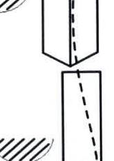
Photographs from the Route
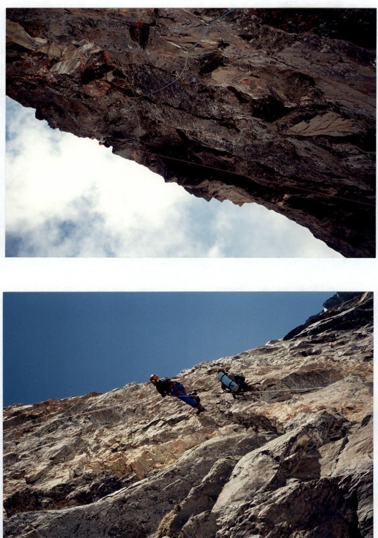
Below — 1st night camp, section R3. Above — passage of section R4–R5, Gubanov R. is leading.
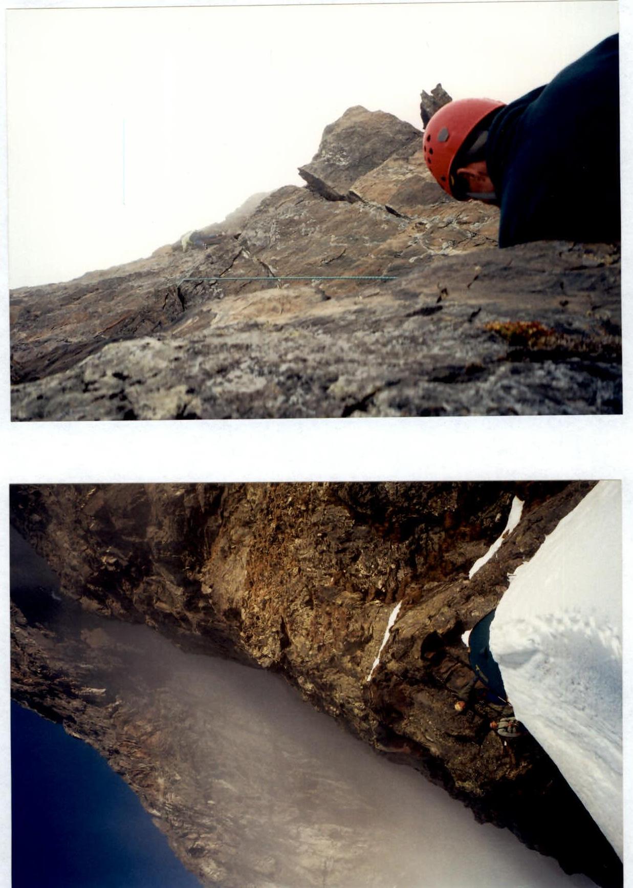
Photographs from the Route
Below — section R4–R5, Aliev R. is climbing along the fixed ropes. Above — passage of section R9–R10, Eliseev A. is leading.
Photographs from the Route
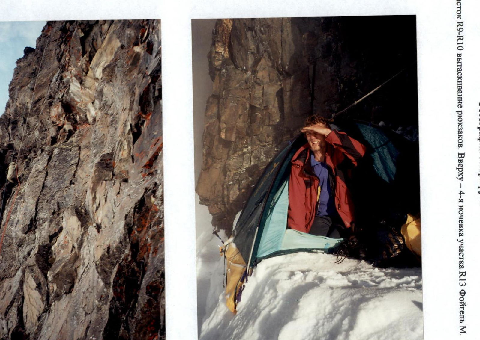
Below — section R9–R10: pulling up backpacks. Above — 4th night camp, section R13 (Foigel M.).
Photographs from the Route
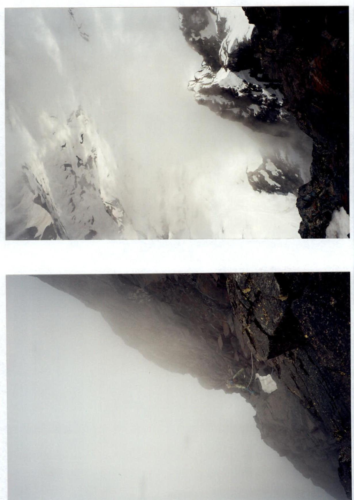
Below — section R16–R17: Gubanov R. is climbing along the fixed ropes. Above — view of our route from the wall of the 2nd bastion.
Comments
Sign in to leave a comment