ASCENT LOG
- Ascent category — technical.
- Region of ascent — Caucasus, Dombay.
- Ascent to the summit Amanauz (Dvuzubka) via the east wall 3600 m, category 6A. Kavunenko Route.
- Height difference of the wall section is 695 m. Total route length is 804 m. Length of sections with category 6 difficulty is 135 m.
- Average steepness of the wall section is 62°.
- Number of pitons driven:
| Rock | Ice | Bolt | Chocks |
|---|---|---|---|
| 21+7 | 0 | 25 | 120 |
| 20 | 2 | 0 | 30 |
- Number of climbing hours — 22, days — 2.
- Number of bivouacs — 1. Comfortable, lying on a ledge.
- Water and snow are available in the lower part of the wall.
- Team leader: Alexandrov A.A. Master Candidate.
Team members:
- Rispolozhensky I.Yu. 1st category
- Kapustin A.E. 1st category
- Kravchenko O.V. Master Candidate
- Team coach: Gorbachevsky Alexander Dmitrievich.
- Approach to the route on July 23, 1994.
Reached the summit Amanauz (Dvuzubka) on July 24, 1994. Returned to base camp on July 26, 1994.
- Ascent organized by the Krasnodar Club of Mountaineers and Climbers "Krokus".
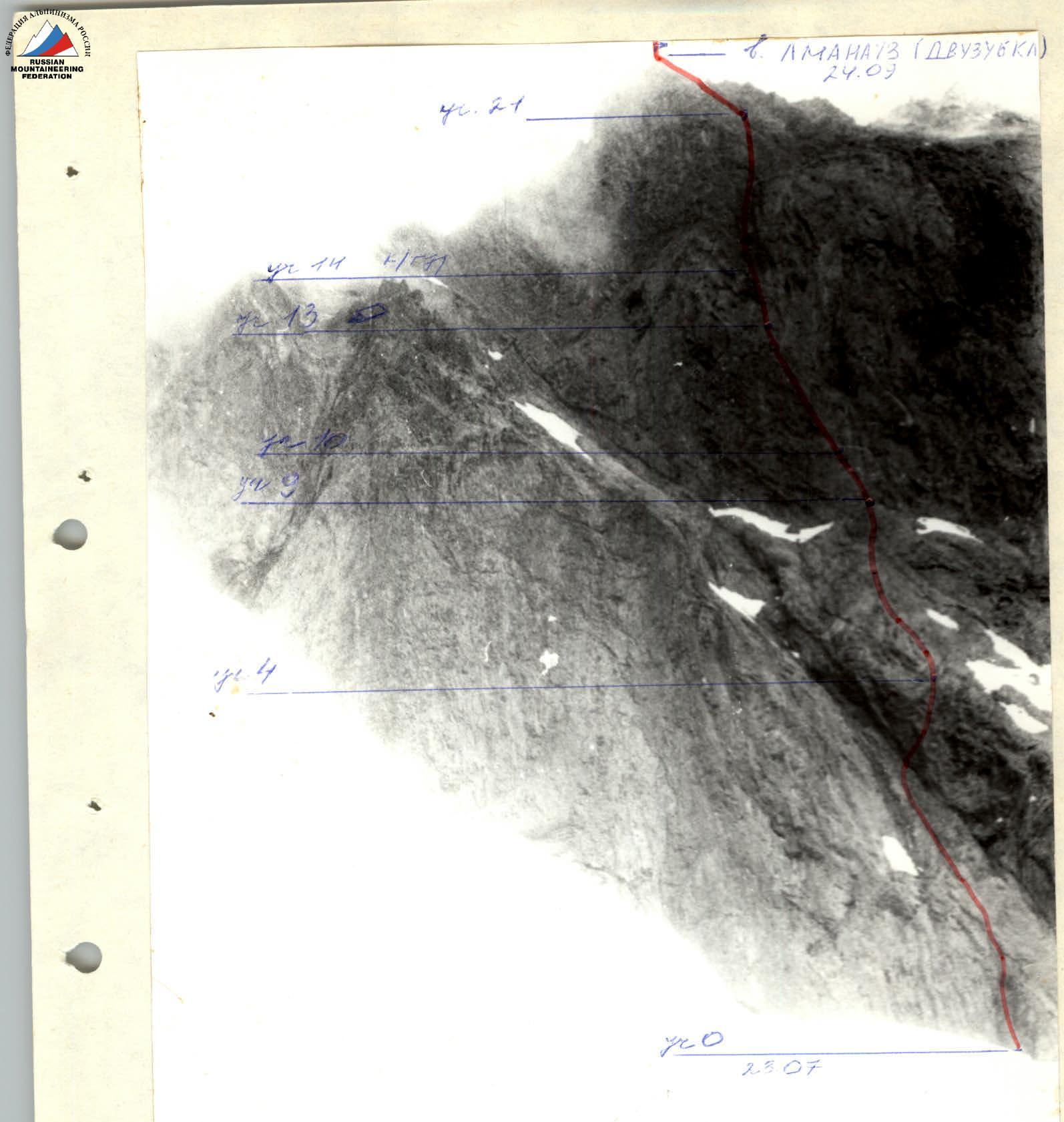
Photo #2. Technical photograph of the route.
Route description by sections
A distinctive feature of this route is that it is impossible to unintentionally deviate from it, as the start of the route is the only logical path up the rock. To the left and right, the wall is very difficult and is washed by water. In the middle part, it is a clearly defined buttress. On the second bastion, the route follows the only possible sections that can be climbed by free climbing. In the middle part of the wall, there are two ledges where a comfortable bivouac can be set up, and the tactical plan was built with this in mind. Water and snow are available only in the lower part of the route.
Section 0–1
- Vertical chimney with an exit to a ledge.
Section 1–2
- Vertical wall turning into an internal corner with a small number of holds.
- Intermediate protection on chocks in a vertical crack.
- On the right side of the corner — exit through an overhang, passable by free climbing on steep rocks like "ram's foreheads".
Section 2–3
- Straight up the "ram's foreheads" of a wide groove.
- Intermediate protection is impossible — there are no cracks for pitons or chocks.
Section 3–4
- Up steep, broken rocks on the right side of the groove — exit to the buttress.
Section 4–9
- Along moderately difficult rocks of the buttress — approach to the second bastion.
- The section is objectively rockfall-prone.
Section 9–10
- Last place on the wall where water can be collected.
- Up a 10-meter steep internal corner and a steep wall — straight up.
Section 10–11
- Up difficult, vertical, and in places overhanging rocks — up-left to a small overhang.
- Then — right-up along a difficult vertical wall.
- Difficulties with organizing intermediate protection — there are no cracks.
Section 11–12
- Up-left along a steep internal corner.
- Protection via chocks in vertical cracks.
Section 12–13 Left-up along large blocks of moderate difficulty, broken rocks to a ledge. A comfortable lying bivouac is organized.
Section 13–14 Left-up along an inclined internal corner with an exit to a large ledge. Traditional overnight spot. Currently, organizing a comfortable bivouac is impossible, as the ledge is littered with blocks.
Section 14–15 Steep internal corner with smooth walls. Climbed by free climbing. Exit to a wall with many holds.
Section 15–16 Descent left-down to the base of a vertical internal corner. Up the corner through an overhang to a vertical, broken wall. Protection via bolt pitons.
Section 16–17 Steep, broken wall, ending in a narrow ledge.
Section 17–18 Right-up along steep, broken, large-block rocks to the base of an internal corner.
Section 18–19 Steep, smooth internal corner with a small number of holds. Protection via chocks. Exit to a difficult vertical wall.
Section 19–20 Difficult wall, exit to the top point of a pendulum. Pendulum to the right. Up steep, very broken rocks to a ledge.
Section 20–21 Steep, broken wall, leading to the base of the pre-summit buttress.
Section 21–26 Above moderate difficulty, in places difficult, broken rocks of the buttress. Exit to the summit.
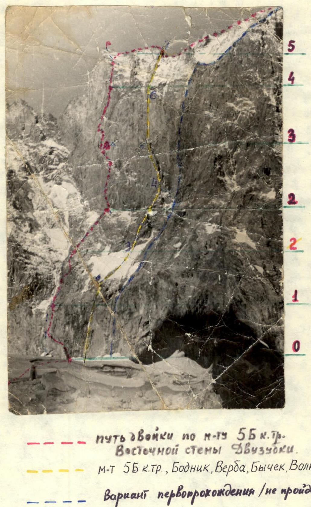
East wall of Dvuzubka

Table
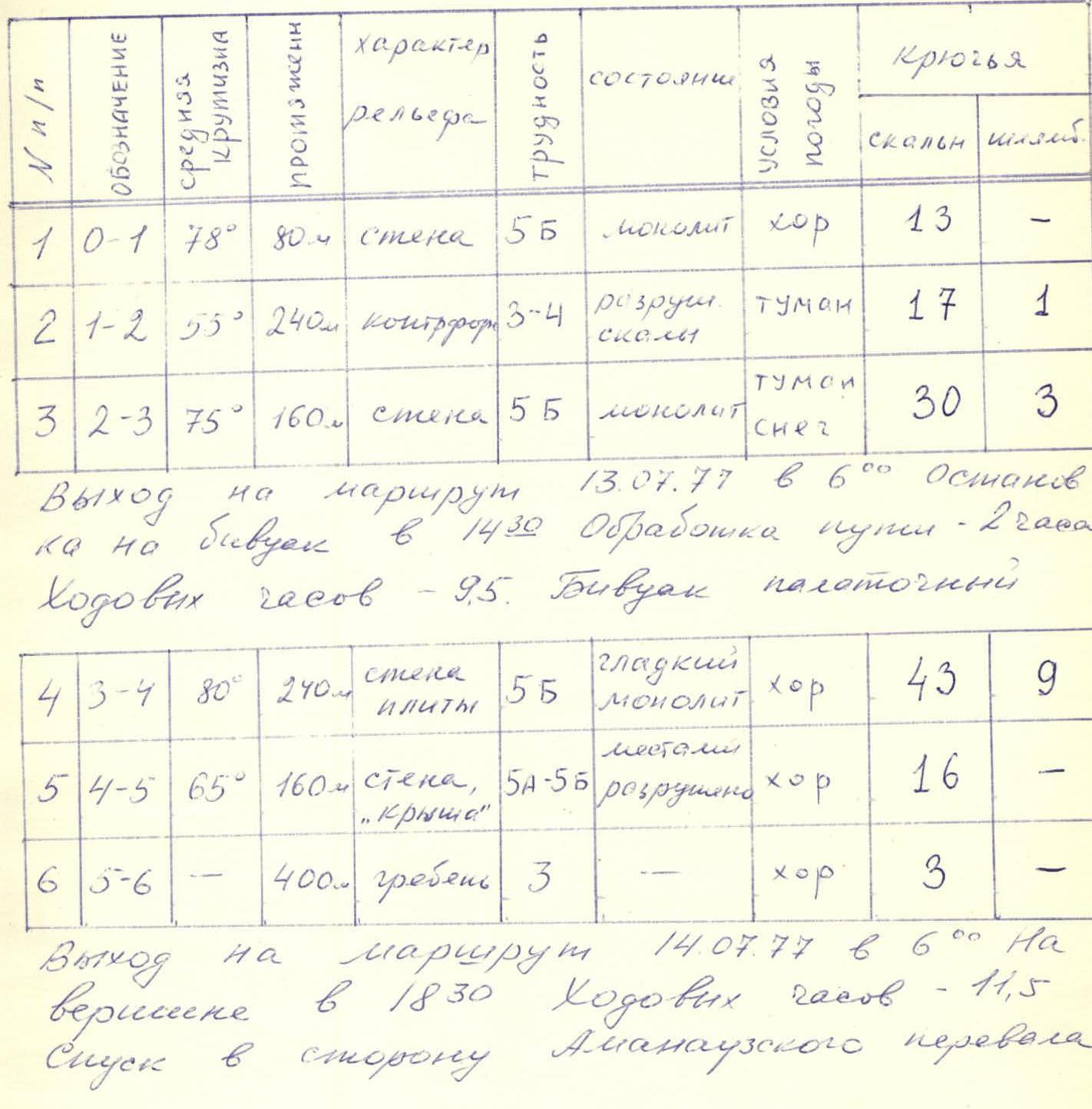
| № | Designation | Average steepness | Length | Terrain characteristics | Difficulty | Condition | Weather conditions | Rock pitons | Bolt pitons |
|---|---|---|---|---|---|---|---|---|---|
| 1 | 0–1 | 78° | 80 m | Wall | 5 | Monolithic | Good | 13 | — |
| 2 | 1–2 | 55° | 240 m | Buttress | 3–4 | Loose | Fog | 17 | 1 |
| 3 | 2–3 | 75° | 160 m | Wall | 5 | Monolithic | Fog, snow | 30 | 3 |
Approach to the route on July 13, 1977, at 6:00. Stop for bivouac at 14:30. Route reconnaissance — 2 hours. Climbing hours — 9.5. Tent bivouac.
| № | Designation | Average steepness | Length | Terrain characteristics | Difficulty | Condition | Weather conditions | Rock pitons | Bolt pitons |
|---|---|---|---|---|---|---|---|---|---|
| 4 | 3–4 | 80° | 240 m | Wall, slabs | 5 | Smooth, monolithic | Good | 43 | 9 |
| 5 | 4–5 | 65° | 160 m | Wall, "Roof" | 5–5 | Broken | Good | 16 | — |
| 6 | 5–6 | — | 400 m | Ridge | 3 | — | Good | 3 | — |
Approach to the route on July 14, 1977, at 6:00. On the summit at 18:30. Climbing hours — 11.5. Descent towards Amanauz Pass.
Climbing diary
July 12, 1977. Departure from camp at 10:00 and approach to the wall (7 hours). Setting up a bivouac. Route reconnaissance to a ledge on section 0–1 (2 hours).
July 13, 1977. Approach to the route at 6:00. Rest before section 2–3 (0.5 hours). Weather deteriorated: drizzle, then snow. Visibility 20–30 m. Reached the bivouac site at 14:30. Organized bivouac, lunch. Further route reconnaissance — 2 hours.
July 14, 1977. Approach to the route at 6:00. Weather not good, but visibility better. On the summit at 18:30. Descent via route category 3B. Overnight under the "black" gendarme.
July 15, 1977. Return to Dombay tourist camp.