All-Union Council of the DSO Trade Unions Department of Mountaineering Alplager "Dombay"
Caucasus
(2.2. from Marukh pass to Nakhar pass)
Amanauz Main (Dvuzubka)
3757 m
via north-eastern wall through the "mirror"
| BODNIK V.N. | CMS | "Burevestnik" | team leader |
|---|---|---|---|
| BYCHEK A.M. | CMS | "Burevestnik" | participants |
| VERBA A.A. | CMS | "Burevestnik" | participant |
| VOLKOV L.B. | CMS | "Burevestnik" | participant |
1977
Climbing Description
The route via the north-eastern wall of the Main Amanauz (Dvuzubka) is combined, featuring two steep rock bastions separated by a wide, steep snow shelf. After the second bastion, the path leads to the "roof" of the wall with significant steepness and then follows the ridge to the summit of Dvuzubka.
The beginning of the route is to the right of the right (far) avalanche cone, along slabs leading upwards to the right.
July 6
At 9:00, the pair Bodnik - Verba started processing the route. Along the slabs to the right and upwards 20 m, then upwards 20 m through an internal corner. The rocks are smoothed, wet in several places, making climbing very difficult. From here, a five-meter cornice (105°), continuing upwards, overcoming another 10 m of difficult rocks on a steep wall. The wall transitions into another internal corner. Along this corner, after 25 m, we reach rocks of medium difficulty. At this point, an anchor is set up, and the pair descends from the wall to the base camp. Processing took 4 hours.
July 7
The entire group departed at 4:00. They quickly traversed the first bastion of the wall along the processed path. Then, 20 m to the left and upwards, crossing a stream, and reaching a rocky ridge, which after 30 m leads to a steep snow ascent. 100 m along the snow to a weakly expressed counterfort of the north-eastern wall. The ascent onto the counterfort is in its central part, then along a shelf upwards to the right (10 m) and up an internal corner (80°, 40 m). Further, directly upwards 90 m to the steep wall of the second bastion. From this point begins a steep, and in the upper part, overhanging wall with a minimal number of holds and a minimal number of cracks for piton placement and belay organization during movement. The most logical path up the wall starts from a narrow shelf, which is the end of the counterfort, and lies directly upwards.
As planned, a sitting bivouac was organized here, under the wall. The rope team Bychek - Volkov continued the ascent, processed 60 m of the wall on the same day, and descended to the bivouac site by 18:00.
July 8
The ascent resumed at 6:00. From the overnight spot directly upwards, 60 m of climbing on monolithic rocks with a steepness of 90° and individual overhanging sections (processed section). Then, transition into a large internal corner. The rocks are wet, icy in some areas, making climbing very difficult (100 m). The transition into the internal corner below is objectively dangerous due to the risk of rockfall from the right, along the path, shaft of the north-eastern wall.
Throughout the 160 m, there are no ledges or platforms where at least one person could stand comfortably.
This section of the wall ends with two shelves, one above the other, 7 m apart. After careful preparation of these shelves, a sitting bivouac was organized. The location is not dangerous; the lower shelf can accommodate three people, and the upper one can accommodate one.
On the same day, the rope team Bodnik - Verba processed 110 m of the "mirror". The further path through the most complex part of the wall, the "mirror", begins from the upper shelf. The "mirror" crosses from right to left a rock belt in the form of a cornice. Its height is ten meters, and it protrudes about two and a half meters above the "mirror". The height of the "mirror" is 160 m.
The first 120 m have a negative steepness, reaching 105° when overcoming the protruding belt. The overall steepness of the 120 m "mirror" is 95°, and the upper 40 m is 90°.
Surface characteristics:
- Very few cracks.
- Extremely few holds.
- Holds are in the form of vaguely expressed protrusions, depressions, and surface roughness.
To traverse, it was necessary to use a platform and ladders, but the main part of the "mirror" was climbed using free climbing.
The path across the "mirror" proceeded as follows:
- From the upper shelf, 12 m to the left and upwards, and then 55 m straight up to a chimney, through which water flows. The chimney walls are absolutely smooth, almost without cracks, overhanging, and extremely difficult to pass. However, this is the safest and most logical path. From the chimney, in its middle part (after 20 m), we move to the right onto the wall, and along it, after 25 m, turn into an internal corner, where many loose rocks are present, further complicating the passage. Here, the pair secured the rope and began descending to the bivouac site at 18:30.
July 9
Departure at 6:00. Initially, movement along the processed path, and then:
- 20 m along the internal corner;
- further upwards to the left, 30 m to the largest platform, where the entire group can gather.
From this point begins the "roof" of the summit. Its steepness is 50°, and it is entirely covered with deep, loose snow. From a minor rock that detaches in the upper part of the "roof", a large avalanche of snow with rocks forms towards its lower part, and this entire mass rushes down, washing around both sides of the "mirror" of the north-eastern wall and the entire route traversed by the group. The simplest path to overcome the "roof" is to move upwards to the right along the snow to the saddle between Dvuzubka and the Main Amanauz. However, due to the high avalanche danger on this path, the group chose another, more technically complex but safe route, i.e., from the exit point to the "roof", seven meters to the left and straight up to the ridge leading to the right peak of Dvuzubka, and after 200 m, exit to the summit. Further descent onto the saddle between Dvuzubka and the Main Amanauz, where another bivouac was organized at 16:00.
July 10
Departure at 7:00. The further path lies along a relatively simple ridge to the summit of the Main Amanauz. The group reached the summit at 8:30.
The descent was carried out via the route of category 3B difficulty to the Amanauz pass and further to the "Dombay" alpine camp, which the group arrived at by 17:00.
TABLE I of the main characteristics of the ascent route to v. Main Amanauz (Dvuzubka) via the north-eastern wall through the "mirror"
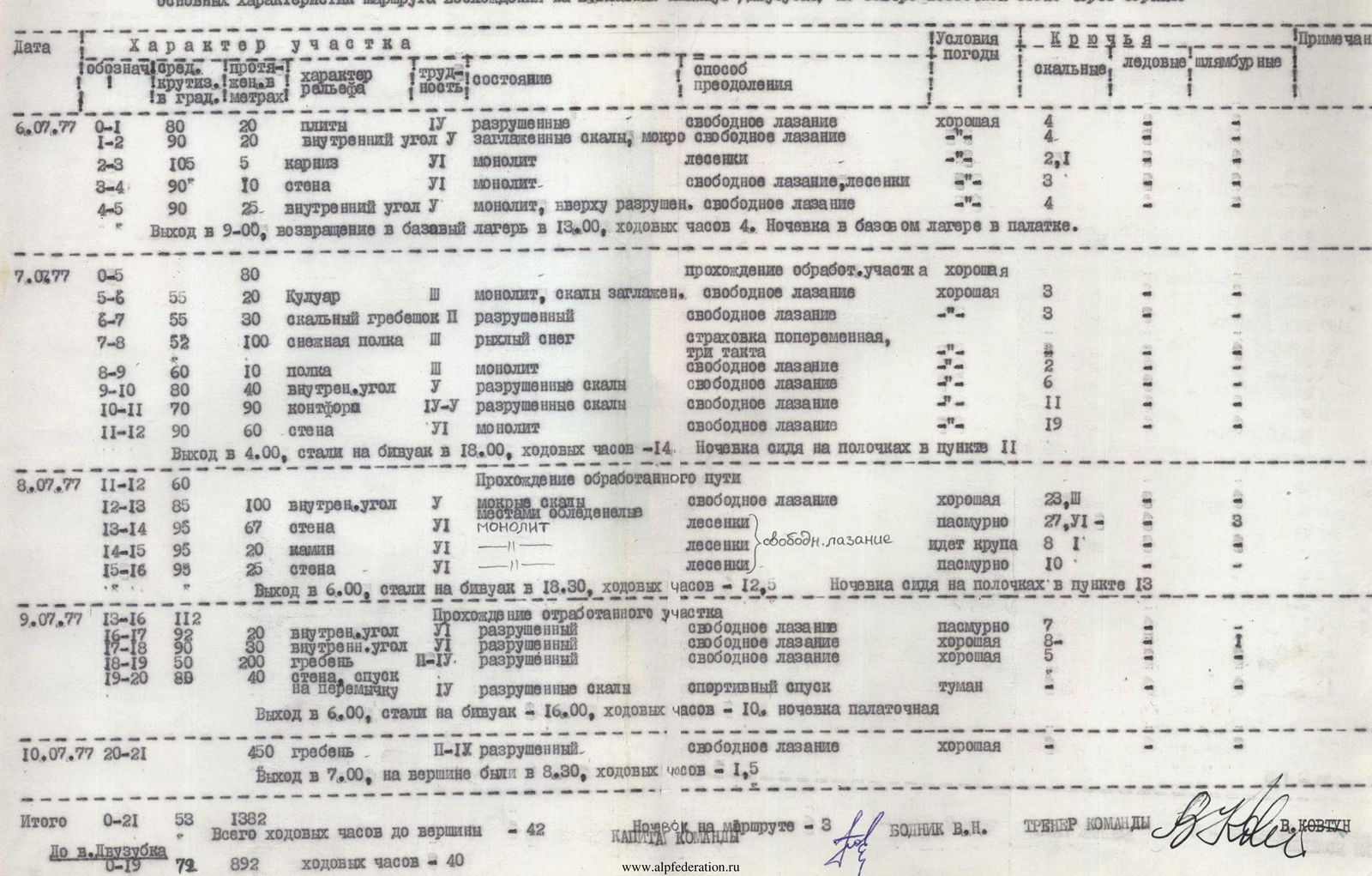
| Date | Section | Length, in m | Steepness, in degrees | Relief | Difficulty | Condition | Method of overcoming | Weather conditions | Rock pitons | Ice pitons | Bolt pitons | Notes |
|---|---|---|---|---|---|---|---|---|---|---|---|---|
| 06.07.1977 | R0–R1 | 20 | 80 | slabs | 4 | destroyed | free climbing | good | 4 | |||
| R1–R2 | 20 | 90 | internal corner | 5 | smoothed rocks, wet | free climbing | 4 | |||||
| R2–R3 | 5 | 105 | cornice | 5 | monolith | ladders | 2 | 1 | ||||
| R3–R4 | 10 | 90 | wall | 6 | monolith | free climbing, ladders | 3 | |||||
| R4–R5 | 25 | 90 | internal corner | 5 | monolith, destroyed at the top | free climbing | 4 | |||||
| Departure at 9:00, return to base camp at 13:00, 4 hours of climbing. Overnight in base camp in a tent. | ||||||||||||
| 07.07.1977 | R0–R5 | 80 | passage of processed section | good | ||||||||
| R5–R6 | 20 | 55 | couloir | 2 | monolith, smoothed rocks | free climbing | good | 3 | ||||
| R6–R7 | 30 | 55 | rocky ridge | 2 | destroyed | free climbing | 3 | |||||
| R7–R8 | 100 | 52 | snow shelf | 3 | loose snow | alternate belay, three moves | ||||||
| R8–R9 | 10 | 60 | shelf | 2 | monolith | free climbing | 2 | |||||
| R9–R10 | 40 | 80 | internal corner | 5 | destroyed rocks | free climbing | 6 | |||||
| R10–R11 | 90 | 70 | counterfort | 4–5 | destroyed rocks | free climbing | 11 | |||||
| R11–R12 | 60 | 90 | wall | 6 | monolith | free climbing | 19 | |||||
| Departure at 4:00, reached bivouac at 18:00, 14 hours of climbing. Sitting bivouac on ledges at R11. | ||||||||||||
| 08.07.1977 | R11–R12 | 60 | passage of processed path | |||||||||
| R12–R13 | 100 | 85 | internal corner | 5 | wet rocks, icy in places | free climbing | good | 23 | 5 | |||
| R13–R14 | 67 | 95 | wall | 6 | monolith | ladders | overcast | 27 | 5 | 3 | ||
| R14–R15 | 20 | 95 | – | 6 | – | ladders, free climbing | sleet | 8 | 1 | |||
| R15–R16 | 25 | 95 | wall | 6 | – | ladders | overcast | 10 | ||||
| Departure at 6:00, reached bivouac at 18:30, 12.5 hours of climbing. Sitting bivouac on ledges at R13. | ||||||||||||
| 09.07.1977 | R13–R16 | 112 | passage of processed section | |||||||||
| R16–R17 | 20 | 92 | internal corner | 6 | destroyed | free climbing | overcast | 7 | ||||
| R17–R18 | 30 | 90 | internal corner | 6 | destroyed | free climbing | good | 8 | ||||
| R18–R19 | 200 | 50 | ridge | 2–4 | destroyed | free climbing | good | 5 | ||||
| R19–R20 | 40 | 80 | wall, descent to saddle | 4 | destroyed rocks | sport descent | fog | |||||
| Departure at 6:00, reached bivouac at 16:00, 10 hours of climbing. Tent bivouac. | ||||||||||||
| 10.07.1977 | R20–R21 | 450 | ridge | 2–6 | destroyed | free climbing | good | |||||
| Departure at 7:00, reached summit at 8:30, 1.5 hours of climbing. | ||||||||||||
| Total | R0–R21 | 1382 | 53 | Total climbing hours to the summit 42 hours. | ||||||||
| To summit | R0–R19 | 892 | 72 | Climbing hours 40 hours. |
Number of bivouacs on the route — 3. TEAM CAPTAIN BODNIK V.N. TEAM COACH V. KOVTUN