Ascent Log
I. Ascent category: rock climbing 2. Ascent area: CAUCASUS, from Marukh pass to Nakhar pass. 3. Peak, its height, and ascent route:
AKSAUT NORTH-EAST (3760 m) via the South-East wall.
- Proposed category of difficulty: 5B
- Route characteristics: height difference 950 m, average steepness 65°, total length of sections: 1300 m.
| including I | none |
|---|---|
| II | none |
| III | 360 m |
| IV | 350 m |
| V | 540 m |
| VI | 50 m |
- Pitons hammered:
| for belaying | for creating artificial holds | |
|---|---|---|
| rock | 123 | — |
| ice | — | 26 |
| bolt | — | — |
- Total climbing hours: 38 hours
- Number of overnight stays and their characteristics: 2 nights I — lying down, on a comfortable platform II — sitting
- Surname, first name, patronymic of the leader and participants, and their sports qualification:
- Senchina Svyatoslav Vladimirovich, Candidate Master of Sports, leader
- Bolizhevsky Valery Konstantinovich, Master of Sports of the USSR, coach
- Labzhinsky Sergey Ivanovich, Candidate Master of Sports
- Onysko Orest Stepanovich, 1st sports category
- Team coach:
- Bolizhevsky Valery Konstantinovich, Master of Sports of the USSR
- Date of departure and return: from July 15 to July 19, 1977
TABLE OF MAIN CHARACTERISTICS of the ascent route via the South-East wall of AKS AUT NORTH-EAST peak (3760 m)
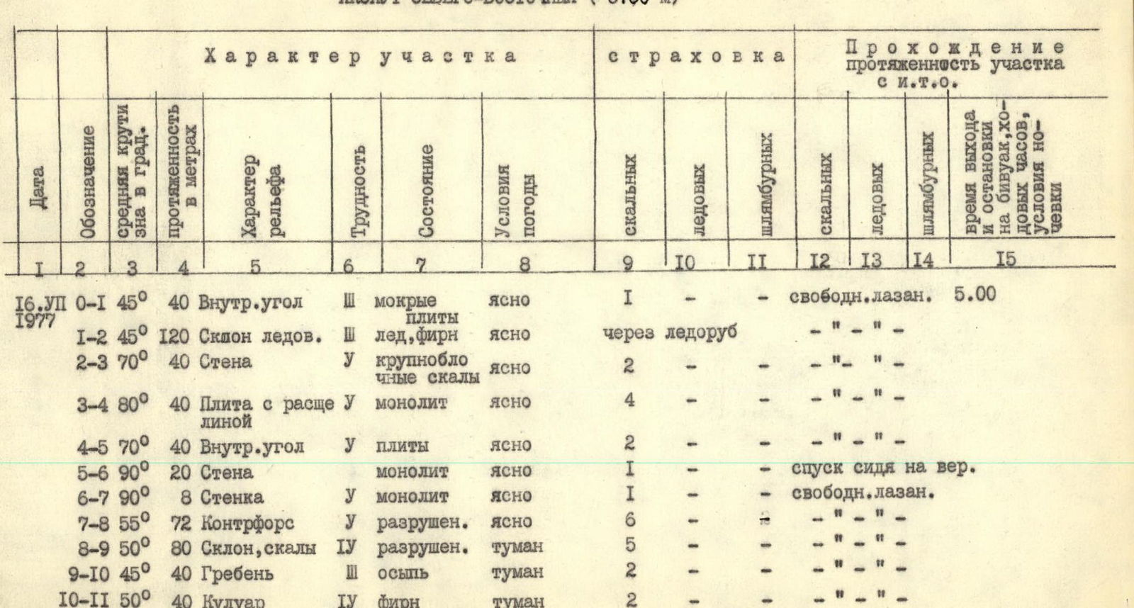
| Date | Designation | Average steepness in degrees | Length in meters | Terrain characteristics | Difficulty | Condition | Weather conditions | Belaying: rock | Belaying: ice | Belaying: bolt | Climbing: rock | Climbing: ice | Climbing: bolt | Time to bivouac, climbing hours, overnight stays |
|---|---|---|---|---|---|---|---|---|---|---|---|---|---|---|
| 16.07.77 | R0–R1 | 45° | 40 | Internal angle | 3 | wet slabs | clear | 1 | — | — | — | — | — | free climbing. 5:00 |
| R1–R2 | 45° | 120 | Ice slope | 3 | ice, firn | clear | via ice axe | — | — | — | — | — | — | |
| R2–R3 | 70° | 40 | Wall | 5 | large-block rocks | clear | 2 | — | — | — | — | — | — | |
| R3–R4 | 80° | 40 | Slab with a cleft | 5 | monolith | clear | 4 | — | — | — | — | — | — | |
| R4–R5 | 70° | 40 | Internal angle | 5 | slabs | clear | 2 | — | — | — | — | — | — | |
| R5–R6 | 90° | 20 | Wall | (none) | monolith | clear | 1 | — | — | — | — | — | rappel descent | |
| R6–R7 | 90° | 8 | Wall | 5 | monolith | clear | 1 | — | — | — | — | — | free climbing | |
| R7–R8 | 55° | 72 | Buttress | 5 | destroyed | clear | 6 | — | — | — | — | — | — | |
| R8–R9 | 50° | 80 | Slope, rocks | 4 | destroyed | fog | 5 | — | — | — | — | — | — | |
| R9–R10 | 45° | 40 | Ridge | 3 | scree | fog | 2 | — | — | — | — | — | — | |
| R10–R11 | 50° | 40 | Couloir | 4 | firn | fog | 2 | — | — | — | — | — | — | |
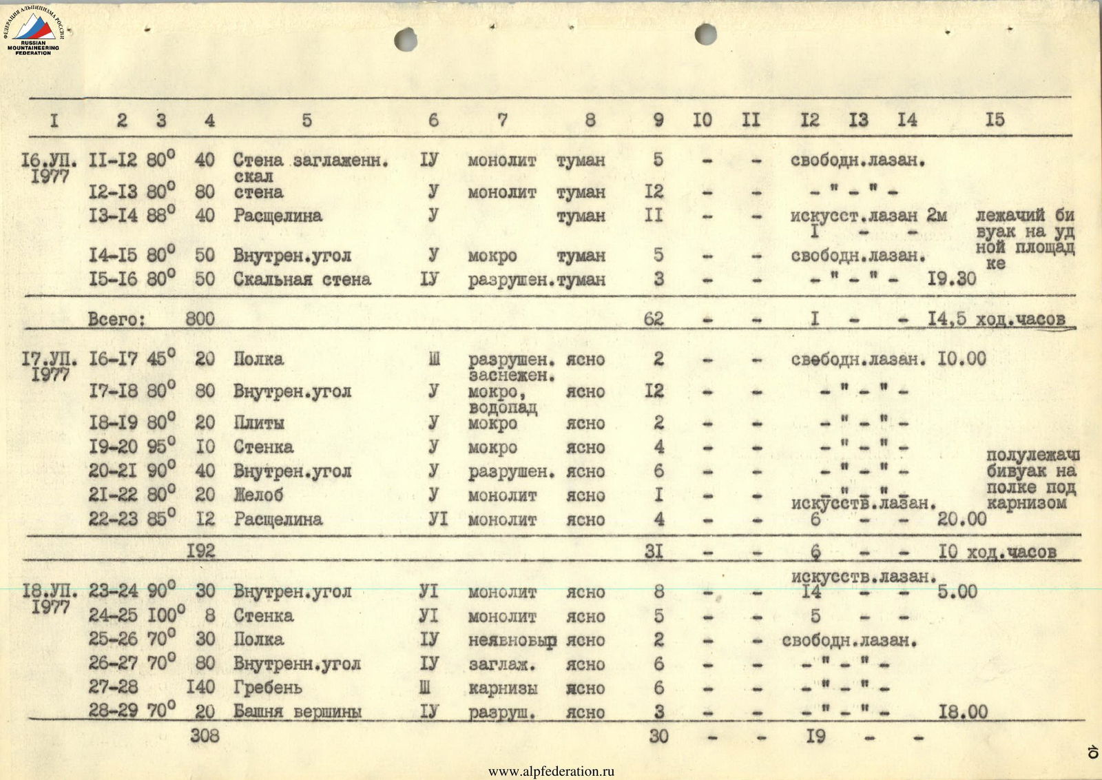
| 16.07.77 | R11–R12 | 80° | 40 | Wall, smooth rock | 4 | monolith | fog | 5 | — | — | — | — | — | free climbing |
| R12–R13 | 80° | 80 | Wall | 5 | monolith | fog | 12 | — | — | — | — | — | — | |
| R13–R14 | 88° | 40 | Cleft | 5 | (none) | fog | 11 | — | 1 | artificial climbing 2 m | — | — | lying bivouac on a comfortable platform | |
| R14–R15 | 80° | 50 | Internal angle | 5 | wet | fog | 5 | — | — | — | — | — | free climbing | |
| R15–R16 | 80° | 50 | Rock wall | 4 | destroyed | fog | 3 | — | — | — | — | — | 19:30 | |
| Total: | 800 | 62 | — | 1 | — | — | — | 14.5 climbing hours | ||||||
| 17.07.77 | R16–R17 | 45° | 20 | Shelf | 3 | destroyed, snow-covered | clear | 2 | — | — | — | — | — | free climbing. 10:00 |
| R17–R18 | 80° | 80 | Internal angle | 5 | wet, waterfall | clear | 12 | — | — | — | — | — | — | |
| R18–R19 | 80° | 20 | Slabs | 5 | wet | clear | 2 | — | — | — | — | — | — | |
| R19–R20 | 95° | 10 | Wall | 5 | wet | clear | 4 | — | — | — | — | — | — | |
| R20–R21 | 90° | 40 | Internal angle | 5 | destroyed | clear | 6 | — | — | — | — | — | — | |
| R21–R22 | 80° | 20 | Gutter | 5 | monolith | clear | 1 | — | — | — | — | — | artificial climbing. sitting bivouac on a shelf under a cornice | |
| R22–R23 | 85° | 12 | Cleft | 6 | monolith | clear | 4 | — | — | — | — | — | 20:00 | |
| Total: | 192 | 31 | — | — | — | — | 6 | 10 climbing hours | ||||||
| 18.07.77 | R23–R24 | 90° | 30 | Internal angle | 6 | monolith | clear | 8 | — | — | — | — | 14 | artificial climbing. 5:00 |
| R24–R25 | 100° | 8 | Wall | 6 | monolith | clear | 5 | — | — | — | — | 5 | — | |
| R25–R26 | 70° | 30 | Shelf | 4 | vaguely defined | clear | 2 | — | — | — | — | — | free climbing | |
| R26–R27 | 70° | 80 | Internal angle | 4 | smooth | clear | 6 | — | — | — | — | — | — | |
| R27–R28 | (none) | 140 | Ridge | 3 | cornices | clear | 6 | — | — | — | — | — | — | |
| R28–R29 | 70° | 20 | Summit tower | 4 | destroyed | clear | 3 | — | — | — | — | — | 18:00 | |
| Total: | 308 | 30 | — | — | — | — | 19 | — |
Description of the ascent route
July 16, 1977. Departure at 2:00 AM. With headlamps, we quickly descend from the "ram's foreheads" along a familiar path, cross the horizontal section of the Dzhalovchatsky glacier, and ascend via the icefall. Twelve-toothed crampons of the "Tirol" model greatly facilitate the ascent. By 5:00 AM, we reach the beginning of the route.
We climb in pairs: Senchina — Bolizhevsky, Onysko — Labzhinsky. Backpacks are light, making the ascent pleasant. Initially, we traverse approximately one rope length of slab-like rocks (R0–R1), followed by two rope lengths of steep snow on the right "spur." The terrain becomes steeper, and ice appears. The path crosses a wide crevasse, the upper edge of which overhangs. We traverse a steep, wet shelf to the left onto the "spur" (R2–R3). The "spur" comprises a series of gendarmes. Climbing is very challenging, and bypassing steep walls is impossible. We establish a belay for the second pair.
By 1:00 PM, we complete the "spur" and, after traversing a narrow, steep ice gully in a couloir (between avalanches), we reach the main wall. Here, the climbing difficulty remains at least 5B category. The terrain is consistently steep. There are no platforms, and the ledges are narrow and sloping. The rocks are smooth, resembling "ram's foreheads," with thin, shallow cracks for piton placement. Thanks to our good physical condition, we climb independently in pairs. Only on the section R13–R15, where approximately 5 meters require very difficult, strenuous climbing on an overhanging section, do we use a rope.
By 7:30 PM, we reach the planned bivouac site, where a wide ledge crosses the left part of the wall. On a rock outcrop at the end of this ledge, we prepare a platform for a lying-down overnight stay.
July 17. At night, there was a thunderstorm with heavy snowfall. We had to shake off the snow from the tent several times to prevent it from being buried. In the morning, the weather cleared up again, and the sun appeared. However, climbing was impossible due to water flowing down the wall. Only at 10:00 AM did Senchina decide to continue the ascent.
Climbing was significantly complicated by snow and water streaming down the rocks. Initially, we worked on two rope lengths upward along a steep internal angle with separate vertical steps, and then, ensuring we could reach a comfortable ledge for the night, we descended to our backpacks and quickly traversed the processed section. Another half rope length on smooth, but less steep rocks, and we reached an inclined ledge under a cornice.
While one pair worked on the wall above the ledge, the other two prepared a platform for a sitting bivouac. On this day, we managed to process another two rope lengths of the complex wall section above the ledge (R19–R23). The first 10 meters overhang, followed by an ascent via a steep gutter, and then a shallow internal angle with completely smooth, vertical walls.
July 18. We quickly traverse the processed section. Considering the high difficulty of the section ahead, the first climber goes with a significantly lightened backpack (no more than 5 kg).
In the internal angle (R23–R24), we frequently use ladders and chocks. Climbing is hindered by numerous "live" slabs literally stuck to the angle's walls. The angle's middle section is covered by a small cornice, and after 50 meters, it transitions into a large overhang, from which we exit leftward along an inclined slab. The ascent continues through a monolithic, overhanging wall topped with a small cornice (0.4 m). Only by 2:00 PM do we manage to ascend to a small platform (R25).
A 20-meter traverse to the right from the platform along a vaguely defined ledge leads to the base of a wide rock gully composed of wet, smooth, but less complex rocks. We ascend the gully to the pre-summit ridge.
The ridge is steeply cliffed on both sides and crowned with enormous cornices inclined to the south. We climb with careful belaying, using pitons hammered into the gaps between snow cornices.
We reach the summit around 6:00 PM. On the summit itself lies a large snowdrift; the cairn is not visible. Slightly below the summit, at the beginning of the descent, we construct our own cairn.
Descent: — 40-meter rappel to the saddle between the North-East and 2nd North peaks; — From here, along a steep snowy slope, we bypass the summit tower of the North-East peak to the left and exit onto the north ridge; — Here, we prepare a comfortable platform and settle in for the night.
July 19. We continue descending along the north ridge toward North Aksaut. Then, via the rocks on the eastern slope of the peak, we descend to the glacier and, through the icefall (in crampons), descend to the Dzhalovchatsky glacier. We reach the initial bivouac site by 8:00 PM. Observers had previously informed us that the control deadline had been extended by one day at our request, i.e., until July 21.
July 20. We return to the camp via the Dzhalovchat pass.
,{"width":1321,"height":1832,"format":"Jpeg","uri":"https://summitx.info/media/1/ToT8K63QVHEArSaj4sj6TioRW9PP4Nhj/img-2.jpeg","id":64810726}↗)]
Photo 4. Passage of a difficult wall with a cleft (R13–R14)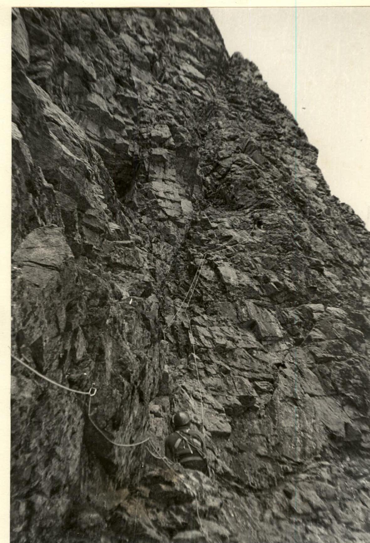
Photo 5. Ascent via wet rocks on section R17–R18.